

Friday 21/9/01
The last time I tried to visit this site was in the middle of summer- a bad idea. The whole well house was covered in vegetation, most of it consisting of brambles and nettles. The only thing which was visible was the finial on the roof known as the cardinals hat. I didn’t get very far before being scratched to bits! So a return visit in the autumn on the way back to Edinburgh after a visit to Traprain Law. This time you can actually see most of the well house which sits in a ditch below road-level. Most of the offending plant life has been cut back too so I can actually get round the outer wall. I shuffle round it on me arse and jump down to the well house. The well house is relatively modern and there’s a metal plaque above the door with a thistle motif which reads ‘16th century historic building’. For such a small well-house the walls are still 25 cm thick, and the building (excluding the roof) is 1.25 m high. An old iron gate, which seems to be permanently open, is attached on the left. Inside the well is almost filled in, though there is still water in the base.
Look under ‘Archaeologies’ and ‘East Lothian’ for more pics and description.
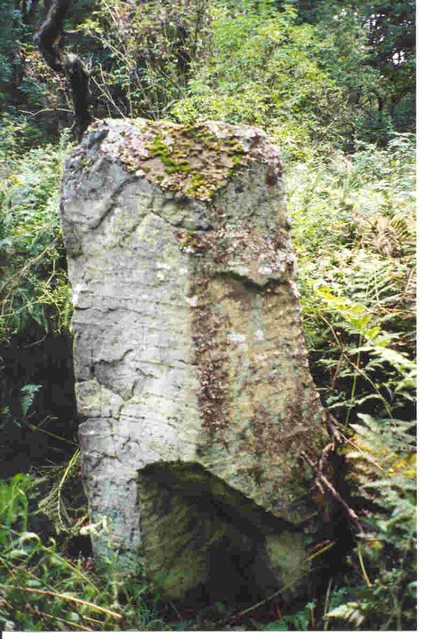
28/8/02- with the section missing from the bottom of the north face


21/9/01 the quiet country road with the stone in the hedgerow
This site is where the last witch in Scotland was burnt according to local legend. The nearby village of Spott was notorious for its witches in the 17th and early 18th centuries and this stone is placed near the spot where Marion Lillie, the Ringwoodie Witch, was burnt about 1698.
Friday 21/9/01
In the hedgerow next to a quiet and lonely road stands this small megalith only about 50 cm high and almost hidden in the hedge and undergrowth were it not for the iron railings which surround it. Why on earth surround this small stone with tall spiked iron railings? Was it to protect the stone? From what? It’s a little used country road. Or was it to try and stop folk performing rituals and lighting candles here as could be seen from all the wax on top. A lonely and unsettling place.

21/7/04- St. Triduana atop the wellhouse with her thorn stick for plucking out her eyes!

Legend has it that St. Triduana was one of a group of holy nuns who accompanied St. Regulas to Scotland from Constantinople as early as 337 AD. They brought with them relics of St. Andrew. Her beauty, and especially her exquisite eyes attracted the attention of the Pictish King Nectan. Triduana wasn’t keen on the attention and asked Nectan what is was about her that he loved. On being told it was her eyes she gouged them out and presented them to Nectan on a thorn. Nice!
Wednesday 21/7/04
I collect the keys from St. Margaret’s House in Lochend and drive up here. Restalrig has changed a lot since I were a lad! This part of the city has been beautifully renovated with lovely steel benches and some great masonry work. I make my way in to the churchyard and round to the wellhouse. From a wooden door steps descend down to an old wood and iron door. As I turn the key in the lock it echoes round the wellhouse behind it. The door opens and the air is damp and musty. A vaulted ceiling greets me and I descend the stone steps to the wellhouse floor which is slippy and slimy! The central pillar holds the five sections of the vaulted ceiling and high above on the left hand side there is a statue of St. Truduana. This wellhouse is actually below both ground level and the water table and therefore floods regularly. On the right hand side there is a large (and very heavy) stone slab which can be lifted to reveal the well/water table where one can bathe ones eyes.
From the THES 9/7/04;
It’s Brit Art, but not as we know it
Steve Farrar
Published: 09 July 2004
The cave engravings emerged first, then shadowy bas-reliefs. Steve Farrar reports
The finest collection of Ice Age bas-relief sculpture found on a cave ceiling is as elusive as it is beautiful. Indeed, the experts who will soon officially announce the discovery overlooked its existence during a preliminary survey.
A search of Church Hole, a cave in Creswell Crags, near Worksop, Nottinghamshire, last year first revealed engraved – as opposed to bas-relief – images of horses, bison, red deer and possibly a wolf that are probably more than 13,000 years old.
Until then, the Ice Age residents of Britain were widely considered impoverished cousins of continental Europeans who produced rich cave paintings and carvings.
But even as that image crumbles, the team admits that the most astonishing achievements of the Creswellian artists initially evaded detection.
“We’d seen no bas-relief before,” says Paul Bahn, an independent scholar and leading Ice Age art expert. “When we first saw the horse’s head, we thought it was a trick of the light.”
The oversight is forgivable. At first glance, only the natural cracks and bumps of the limestone are evident in the cave. But with expert guidance, a menagerie of animals can be espied in the gloom.
Chaotically aligned, overlapping figures peer out from every corner. First come the engraved outlines, which reveal a sophisticated understanding of the animals’ physiology. Then comes the bas-relief, formed by chipping away rock to leave images proud of their background.
Many combine natural features suggestive of an animal with sculpted elements such as an eye, ear or muzzle. Among them is a large brown bear and the horse – a haunting image with a bas-relief mane – whose mouth is formed by a white chip of mineral in the rock.
Paul Pettitt, lecturer in human origins at Sheffield University, who organised the search for UK cave art with Dr Bahn 18 months ago, notes how a minimum of elaboration was often enough to complete the picture.
“They bring out the ghost of these animals’ form,” he says.
When the experts began the work, they dared not imagine they would enjoy such success. Dr Pettitt and Dr Bahn were joined by Sergio Ripoll, a leading Ice Age art specialist at the Spanish Open University, who is renowned for having “the eyes” to detect previously unrecognised cave art.
They started at Creswell Crags, where traces of Ice Age people had been found. Twenty minutes after entering Church Hole something caught Dr Ripoll’s eye.
“I saw a line and suddenly a head was there. I then said a very big bad word in Spanish – it was so exciting,” Dr Ripoll says. He had found the outline of what later turned out to be a red deer stag.
Since then, up to 81 possible pictures have come to light, most emerging since international experts descended on Creswell in April to discuss the discoveries.
The artists are thought to have been the first hunter-gatherers to return to Britain after the last Ice Age.
Dr Pettitt says the artwork suggests strong cultural links between the people of Creswell Crags and their counterparts elsewhere on the great plain that once linked Britain to Germany.
The experts admit they can only guess what the pictures meant to the artists, though their sheer number suggests they were intensely personal.
Dr Pettitt interprets boomerang-shaped figures found deep in the cave as highly stylised depictions of dancing women similar to those found on the continent. His colleagues are not convinced.
“We still argue for hours and bounce ideas about,” Dr Bahn says.
The evidence is still coming in. It seems likely that Church Hole was completely covered in pictures, while the handful of images identified in other Creswell caves makes it possible that the entire gorge was decorated.
The pictures might even have been brightly painted – a possibility that infra-red imaging could soon confirm.
With more discoveries possible elsewhere in Britain, it seems the original exponents of Brit Art are finally getting recognition.
From the Press and Journal- Aberdeenshire shaman builds a new recumbent circle with another one planned soon;
pressandjournal.co.uk/displayNode.jsp?nodeId=62692&command=displayContent&sourceNode=62244&contentPK=10013530
Evidence suggests that cave dwellers may have been flint mining as early as 300,000 years ago (from Nature Science);
nature.com/nsu/040517/040517-4.html
Perthshire Archaeology Week will be held this year from 29/5/04 to 6/6/04.
Details can be found at;
www.perthshire.co.uk/archaeologyweek
This page will be updated as the programme is finalised (not much on there today). Details can also be obtained from Douglas Ritchie in the Tourist Board in Perth (01738 627958) or David Strachan, Perth and Kinross Heritage Trust (01738 447855).
This years Archaeological Research in Progress conference in Aberdeen on the 29th May will examine recent and ongoing projects in the North East of Scotland. The programme looks interesting including a talk entilted ‘The moon and the bonfire: recent excavations at recumbent stone circles’.
Full details here;
britarch.ac.uk/csa/arp.html

3/5/04- even greater panorama including the skyline of the Pentland Hills

3/5/04- overview of the site (which is at the top left hand corner of the wood on the right). Note Arthurs Seat left of centre and the taps O’ Fife across the Firth of Forth.

3/5/04- cairn in the foreground with the ridge of the Moorfoot Hills running away SE.

3/5/04- one of the largest cairns with a diameter of approximately 4 m.
Monday 3/5/04
I drive past this site (well, on the road waaaaaay above it) almost every day and finally get round to a visit. It’s a long walk down from the road which climbs up the ridge of the Moorfoot Hills down to the peat moor. The views from here are stunning though- along the Moorfoot ridge, the complete skyline of the Pentland Hills, Berwick and Traprain Laws, Arthurs Seat and across the Firth of Forth to Fife- wow- what a final resting place. I follow the side of a new forest and trust my GPS to find the cemetery. At the end of the trees I start to notice circular patches of light green grass rising ever so slightly from the peat and short heather- just as well I visited at this time of the year otherwise the whole site would have been hidden in vegetation. There are apparently around 50 small cairns here, but I can only count about 30 or so- some of which I have to use my imagination! They only rise about 20 cm from the ground, but the largest is around 4 m in diameter. I guess most have sunk into the peat below. The whole site covers an area of 160 m NS by 70 m EW. Still- an impressive site with great views of some of the major archaeological and megalithic sites of the Lothians.
From the RCAHMS CANMORE site;
‘A sandstone slab, possibly indicative of the remains of a stone burial cist, or a destroyed stone circle’ was noted by GUARD in 1994 when field-walking the route to be taken by the Pathhead to Gladsmuir gas transmission pipeline. ‘The slab was lying loose within the topsoil and thus did not appear to be in its original position.

3/5/04- the stones in the foreground. Just behind the tree, the orange marker for the pipeline.

3/5/04- remains of this circle? Three large sandstone slabs and many large stones at the edge of the field.
Monday 3/5/04
Driving up a dusty and hot track I can see the orange pipeline marker sticking out of the hedge- apparently where the remains of this possible stone circle were first discovered in 1994. There’s a large tree next to the hedge and sure enough, there are three large sandstone slabs and many large stones at the base. I climb up the gate that overlooks the field and check around the pipeline marker, but all clear of stones, so I guess these must be them! The field next to the fence has been meticulously cleared of any stone remains. The large slabs are loose in the ground and lying horizontally, as are the large stones. I check all of them, but no marks apart from possible plough scrapes.
Details of the settlement from RCAHMS CANMORE;
On the S slopes of North Berwick Law are many rock-faced terraces, some of which appear walled, others scooped to form huts or enclosures. On the SW shoulder are two adjoining, stone-walled rectangular enclosures measuring 33ft by 25ft and 22ft by 15ft. Further up the hill are three roughly circular stone-walled enclosures varying from 18ft in diameter to 33ft. On the same level, to the W, is a roughly quadrilateral area 18ft to 20ft across, enclosed by a setting of seven stones, with an entrance in the E wall.
Along the S base of the Law are many stone foundations and kitchen middens. A saucer-shaped midden was found in a quarry; finds, donated to the NMAS in 1923 by Dr Richardson, included assorted bone and stone implements.
Spread over the lower southern slopes of North Berwick Law are five groups of hut circles and enclosures, totalling twenty-one individual structures. A few are oval, but most are circular, varying from 8.0m to 13.0m in diameter; all are scooped. There are indications of cultivation in the form of wasted banks forming strip fields towards the E end of the settlement.
Details of the fort from RCAHMS CANMORE (taken from Feacham 1963);
This fort occupies the summit of North Berwick Law (613ft OD). The remains are mostly scanty, much of the material of the dry-built stone walls having toppled down the steep slopes of the hill. An area measuring about 500ft by about 300ft was enclosed by a wall running on a level of some 50ft below the summit. The terrace immediately below this on the SW was likewise enclosed.
The gentler slope which intervenes between the second wall and the foot of the hill is enclosed by a third wall, several other stretches of which can be seen round the other side of the hill . In this lowest enclosure it is still possible to see the striking remains of numerous circular platforms upon which houses once stood, and several examples of the lowest courses of the stone walls of these.
Details of the cup and ring marked stone from RCAHMS CANMORE;
In 1965 a cist containing a Food Vessel (RMS, EE 156) was found (at NT 2994 6740) during the excavation of the Parkburn long cist cemetery (NT26NE 28). Aligned N and S, the cist was built of four large sandstone slabs and measured 0.8m by 0.45m and about 0.45m in depth.
The E side-slab was in re-use, for it bore part of a heavily weathered multiple ring-mark (RMS, IA 49). The Food Vessel is bipartite, with four lugs and all-over decoration.


16/4/04- looking eastward- the site is in the trees on the ridge of the small hill


From RCAHMS CANMORE;
This long cist cemetery is situated on England’s Hill, some 600m ENE of Parkburn. A large part of the cemetery has been destroyed by a sand and gravel quarry (now disused), but it probably extends into the strip of woodland immediately NW of the quarry, where cists were discovered in 1885. Excavation in advance of sand extraction in 1954 and 1956 revealed 111 cists, all of them aligned roughly ENE to WSW. Two principal groups of cists were identified, separated by a wall running from NE to SW along the crest of the hill; the S group comprised forty widely-spaced cists, most of them well-built with substantial slabs; the N group, which comprised fifty cists, the majority built of slighter stones, was more compact and there was evidence of disturbance and successive construction. The only finds from the cists were part of a jet armlet (RMS, FN 189), a small fragment of iron, possibly a knife blade (RMS, IA 49) and fragments of six rotary querns, three of them in re-use as cist slabs (RMS, BB 115-20). Since the excavations a further six long cists and a Bronze Age cist (see No. 26) have been discovered. One of the cists, which was found in 1962, was built of dressed stones of Roman date, including three arch voussoirs, probably removed from the bath-house of the Flavian fort at Elginhaugh (No. 102); the cist was aligned roughly NE-SW and there was a small sherd of Neolithic pottery (RMS, EO 983) in its fill.
Friday 16/4/04
In front of me hangs a menacing bible-black sky, to the left, the Edinburgh City Bypass and to the right a landfill site. I follow the line of the pylons until it opens to a golf course. Heading up a small hill I am soon hidden by trees and following the arrow on my trusty GPS. The hill soon becomes a tangle of trees and bushes and it’s a bit of a scramble through it all. Somewhere in here are the remains of 111 cists, at least one of which was built with a cup and ring marked stone and many contained Neolithic and Iron Age remains. The GPS tells me I’m on the site, but there is nothing on the ground I am standing on. I explore further as the site once stretched along the ridge of the hill. Unfortunately, a quarry has destroyed the SE section. It looks like the remainder has disappeared under the tree growth. I do, however, find rectangular indentations running approximately NE/SW- one of the few remaining graves? A mostly destroyed site unfortunately. Most remains have gone, no cup and ring marks and very little ground evidence.
From the BBC Scotland News site;
news.bbc.co.uk/1/hi/scotland/3503804.stm
Sparks fly over rare axe head
The axe head was found in a field last year
A Fife man who discovered a rare Neolithic axe head while out walking near his home is facing prosecution for refusing to hand it over.
Under Scots Law such finds are Crown property but until now it is not thought anyone has faced court action.
Michael Kelly discovered the 6,500-year-old axe head, one of only 30 in the UK, in a field last year.
Mr Kelly, from Leslie, has been told that court proceedings will follow if he does not hand over the artefact.
The former film stunt man said he discovered the axe head while scouting locations for a movie script he is working on.
“I didn’t know it was an axe to start with, I just thought it was a fancy stone,” he said.
“I picked it up and took it to the archaeologist and he told me it was 6,500 years old.”
‘Extremely exciting‘
Mr Kelly initially thought his discovery would help him fund his film project – but he was wrong.
Fife Council’s archaeologist Douglas Speirs said that under Scots law such finds were claimed by the Crown.
The items were usually then given to a local museum or, in the case of finds of high importance, to the national museums.
“This is a system which benefits everybody,” said Mr Speirs.
I didn’t ask to find it, I didn’t steal it from anybody
“It enables the shared cultural importance of Scotland to be shared and enjoyed by everybody.”
The axe head is known to have been made at Killin on Loch Tay.
Mr Speirs said it was an “extremely exciting” find and that its real value was in its story.
“It adds to our knowledge of the number of axes produced at that site and it adds to our knowledge of how widely these things were circulated.
“In archaeological terms this is a significant find,” he said.
The Crown has told Mr Kelly that he must hand over the axe head or face prosecution.
The deadline has now passed, but he said he would not budge.
He usually keeps the axe buried in a secret location and warned that he may even leave it there.
“At the end of the day I didn’t ask to find it, I didn’t steal it from anybody,” he said.


