
The dried up hollow at the foot of the earthwork may be a later pond. It did have a vibe though. Several large stones seemed to line its sides, maybe the remnants of something built from something else.
Image credit: Chance - June 2008

The dried up hollow at the foot of the earthwork may be a later pond. It did have a vibe though. Several large stones seemed to line its sides, maybe the remnants of something built from something else.

View showing the highest point of the earthwork at it’s furthest end. The hill side slopped away behind the picture, giving a natural defence. The area was also wooded now, but the earthwork may have once extended round the hills contours.

View looking along the rampart. The oak trees, although pretty, were undermining the earthwork and had invited badgers to build a set within their roots.

View looking along the rampart towards the valley. The two twisted ash trees mark the mid point of the earthwork, where the two sections merge. To the left of this is the dried up hollow or pond.

Wiltshire Downs
The cuckoo’s double note
Loosened like bubbles from a drowning throat
Floats through the air
In mockery of pipit, lark and stare.
The stable boys thud by
Their horses slinging divots at the sky
And with bright hooves
Printing the sodden turf with lucky grooves.
As still as a windhover
A shepherd in his napping coat leans over
His tall sheep-crook
And shearlings, tegs and yoes cons like a book.
And one tree-crowned long barrow
Stretched like a sow that has brought forth her farrow
Hides a king’s bones
Lying like broken sticks among the stones.
Wiltshire Downs – Andrew Young (1885-1971)

The “Happy Day” Stone and the Church.
One of the polystyrene stones used on the 1976 HTV Children’s drama, The Children of the Stones.
This stone was displayed during the 70th anniversary of the Alexander Keiller Museum opening in 1938.
Apparently, a local barn contains a dozen more of these fake stones which are pressed into service around the Avebury henge when required by visiting film makers. One such being the 1998 rock movie, Still Crazy

The “Happy Day” Stone and the Barn.
One of the polystyrene stones used on the 1976 HTV Children’s drama, The Children of the Stones.
This stone was displayed during the 70th anniversary of the Alexander Keiller Museum opening in 1938.
Fieldnotes – Conkwell Stone Circle – Sunday 20-01-08
O.S. Map: Bristol & Bath inc. Keynsham & Marshfield.
Sheet Number: 155 – 1:25000 – ISBN: 9780319239773
The easiest route to this site is as follows;
Leave the A4 at the Bathford roundabout and travel down the A363 towards Bradford-on-Avon. After a mile, you will come to a cross roads with a sign for Warleigh. Take the B road and travel past the Manor school, and up Warleigh Hill. When you reach the top of the hill you will cross the county line into Wiltshire. Just past this, the road comes to a tee junction. Park your car off the road, and the site is to the right.
At first sight this site looked a tip. When me and Scubi63 visited back in January, it contained the remains of an abandoned camp with two tents and much rubbish. I had a copy of Guy Underwood’s 1946 report of his excavations, which includes all the documentation I could find on the site.
The sketch made by Guy was a bit poor so I re-drew it and have posted it up here, together with a detail from the overall site plan. We didn’t have a lot of time and being January; the light would have gone by 5 o’clock in the afternoon. We uncovered enough of the stones to be certain it was the correct place, although some, like the centre stone, No.1 did seem to be missing. A detailed probing of the undergrowth would be needed to update the record.
The following comes from Guy Underwood’s notes from 1946.
No Man’s Land.
This site was illustrated in W.A.M., December. 1945, p. 231, when attention was called to the possibility that certain stones might be the remains of a Stone Circle. It is at the S.W. corner of the main site, and it was this site that called my attention to the main site, and may be associated with it.
Surface quarrying has disturbed the site. Most of the stones north of the road, are of local surface ragstone. Most of those on the south, and No. 1 and 10 to the north, are of finer material and come from lower levels. Some bear stalagmitic deposits indicating the action of water for long periods. These stones, several of which weigh over a ton must therefore have been brought to the site, which occupies the highest point for some distance round. They are printed black on the plan.
Wiltshire Archaeological Magazine Vol. 51, p447 Guy Underwood

Re-drawn map of Conkwell Stone Circle taken from from Guy Underwood’s plan of 1946.
Local ragstones are shown as hollow shapes and the imported stones as solid.

Conkwell Stone Circle – Stones lie in the hedgerow beside the road. On Guy’s map, these would be No. 23, 24 and 25.

Conkwell Stone Circle – Stone No.9. This stone had been smothered in ivy, but was exactly as shown in Guy’s map of 1946.

Conkwell Stone Circle – Stone No.35. Again, this stone had been smothered in ivy, but was also exactly as shown in Guy’s map of 1946.

Conkwell Stone Circle – Stone No.8, 7 or 6. Although not buried, this stone was smothered in moss and leaf litter. Would require a second opinion as to which No. it is on Guy’s map of 1946.

Conkwell Stone Circle – Stone No.27.
This stone was biggest of the bunch at 6 feet in length. It had a “vibe”.

Conkwell Stone Circle – General view of the circle from the centre beside where stone No.1 stood on Guy’s map of 1946, looking towards the road that bisects the site.
This abandoned camp and tents seem to had been here for some time. They probably had no idea it was an ancient site. The “No Man’s Land” status refers to it lying on the Wiltshire/Somerset county border. I was told this was an area known in the past for squatters.

The Northern or Moon Circle
Stone No.207, The Half-a-day Stone reclines in the forground while the Stone of Many Faces, No.206 looks on. The background shows Stone No.201, The Broken Hearted Stone and Stone No.50, The Horse’s Head Stone, of the outer circle.


Looking West from Kitchen Barrow, towards Furze Knoll and Morgan’s Hill.

The Kitchen Long Barrow showing the remains from the only known excavation. Not recorded.

The Eastern side ditch of the Long Barrow looking towards Tan Hill.
A hare’s des-res.

The track up to Kitchen Long Barrow looking South towards the farm

Stone 10 – The Winter Queen’s Stone
Another aspect of the Goddess Tara is shown on the face of the Winter Queen Stone, as she looks out upon the mid-winter sunset.
Also shown are stones; number 9 – the back face of the Barber Stone, number 8 – The Unmoved Stone and number 7 – The Watcher of the South.


Cromlech in Clatford Bottom; “The Devil’s Den”
From “Guide to the British and Roman Antiquities of the North Wiltshire Downs”. by Revd. A. C. Smith, M.A. – 1884
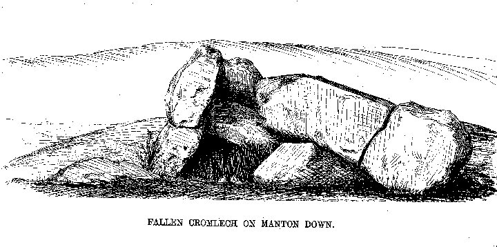
Fallen Cromlech on Manton Down
From “Guide to the British and Roman Antiquities of the North Wiltshire Downs” by Revd. A. C. Smith, M.A. – 1884

Fox Barrow looking north west towards towards Churn Knob and Churn Hill

Fox Barrow looking over the county hedge line north, towards Several Down and the Ridgeway

Fox Barrow looking south east towards the gallops and Compton Down

Fox Barrow looking along the hedge which marks the county line of Oxfordshire and Berkshire.

Looking towards Furze Knoll and the summit, from the Southern gate.

The inner enclosure of Furze Knoll. An ancient flint mine or a gateway to the underworld.

The Wansdyke with the Radio Masts.
The site was only used after Alexander Keiller brought Windmill Hill to prevent the B.B.C. building the first radio transmitter outside London in 1924.

The Wansdyke snakes down to Baltic Farm and across Bishops Cannings Down.

Furze Knoll, with it’s guardian enclosing beech trees, sits on the top of the downs. If the Avebury region is sacred, then this high point must have been marked by something special.

The Wansdyke snakes up to the summit of Morgan’s Hill between the radio masts and Furze Knoll.

This is the site of two Bronze Age Round Barrows. Now the North Wiltshire Golf Club. They might still be there somewhere.

The Bronze age round barrow NMR No. 45564 with Furze Knoll in the background.


The edge of the downs looking towards Calne showing linear features possibly strip lynchets (or trackways).

The fosse caused the Roman Road and the Wansdyke merge, looking east


Disc barrow 608 looking east towards Martinsell Hill

Disc barrow 608 looking into the Pewsey vale as seen from barrow 609

Picked hill on the left and Woodborough hill on the right as seen from the barrow 608

Disc barrow 608 stands 3ft high and is 33ft in dia.

The original disc barrow 608 looking towards Huish.

Looking east towards Martinsell Hill

Huish hamlet at the bottom of Draycott Hill and the glass pyramid which may be a modern masonic temple.
