Chance

Chance

All posts 1,801-1,850 of 2,683 posts
Image of Altar Stone (Oath Stone) by Chance

Altar Stone

Oath Stone

The Altar Stone (80) is the largest of all the ‘foreign stones’ at Stonehenge. It is a rectangular recumbent block of sandstone, 16 ft. long by 3.5 ft. wide by 1.75 ft. deep, embedded in the earth so that its top is level with the surface, about 15 ft. within the central sarsen trilithon.

Two fallen members of this trilithon now lie across it (stones 55 and 156), and their weight has probably pressed it down to its present position. Like the adjoining bluestones, it has been carefully dressed to shape, but its exposed surface is now considerably abraded by the feet of visitors.

Image credit: Chance - March 2008
Image of Altar Stone (Oath Stone) by Chance

Altar Stone

Oath Stone

Three types of stone are shown in this view.

The local sarsen from the Marlborogh Downs, 20 miles to the north, a blue stone from the Prescelly Mountains of Pembrokeshire and the Altar Stone, which is a fine-grained pale green sandstone.
This, interestingly enough, is not in the Prescelly Mountains of Pembrokeshire, the source of the rest of the blue stones, but in the Cosheston Beds (a division of the Old Red Sandstone of South Wales) which crop out on the shores of Milford Haven, further south in the same county.

No other stone composed of this rock is known at Stonehenge, though occasional fragments of it, very probably detached from the Altar Stone itself, have been found in the soil of the site.

Significantly, chips of an entirely different grey-green micaceous sandstone have also been collected on the site, and have been identified with a particular outcrop of the Cosheston Beds at Mill Bay on the south shore of Milford Haven, about 2.5 miles above the ferry at Pembroke Dock.

Image credit: Chance - March 2008

Altar Stone

The Alter stone lies just above the ground surface in the middle of Stonehenge.

The Altar Stone (80) is the largest of all the ‘foreign stones’ at Stonehenge. It is a rectangular recumbent block of sandstone, 16 ft. long by 3.5 ft. wide by 1.75 ft. deep, embedded in the earth so that its top is level with the surface, about 15 ft. within the central sarsen trilithon.

Two fallen members of this trilithon now lie across it (stones 55 and 156), and their weight has probably pressed it down to its present position. Like the adjoining bluestones, it has been carefully dressed to shape, but its exposed surface is now considerably abraded by the feet of visitors.

European Prehistoric Art: inventory, contextualisation, preservation and accessibility

EuroPreArt aims to establish a lasting data-base of European prehistoric art documentation, to launch the base of an European institutional network devoted to this domain, and to contribute to the awareness of the diversity and richness of European Prehistoric Art, as one of the oldest artistic expression of Humankind.

It will improve methodologies on techniques of inventory, storing data, interdisciplinarity, networking and accessibility/diffusion, namely using new information technologies.

The project will focus on selected clusters, from rock art to mobile art, from Palaeolithic to the Iron Age, from old stored records to modern field work studies.

The project intends to create a model, introduce textual and image data, publish a guide of good conduct and present the results to the wider public on this web-site, open to other contributions.

EuroPreArt, funded by the European Union, Education and Culture 2000 Programme

europreart.net/

TMAEds – Could not find a “slot” for this one as pan-european.....

Miscellaneous

Bushy Barrow
Round Barrow(s)

I have listed this site on the TMA as it needs to be explored.
Although a Round Barrow is clearly marked on early OS 25” maps as a Tumulus, when the site was visited by the Ordnance Survey godfather, O.G.S. Crawford in 1932, he couldn’t locate it.
It is unclear if any aerial photographs were available at the time but O.S. Record Card 001 was created on the site and the later visits by L.V. Grinsell, ensured it got a listing in Volume 1 of the Wiltshire Victoria County History in 1957.

Folklore

Pierre-aux-Dames (Musée d'art et d'histoire)
Cup and Ring Marks / Rock Art

Switzerland has very little, if any, folklore concerning megalithic sites. This is because the tribes that lived in the area adopted a scorched earth policy and destroyed all their villages before beginning their doomed mass migration in 58 B.C.. When Julius Caesar burned the bridge of Geneva, to stop the advance of the Helvetii, the area around Troinex would have been trashed too.

See – en.wikipedia.org/wiki/Helvetii

The Pierre-aux-Dames is a mystery of this period. The four sculpted figures are attributed to the Gallo-Roman period due to their dress, the use of metal tools and the craftsmanship employed. That said, the mound and the tombs were clearly placed in the late Bronze Age which could have been 1,000 years earlier. It may be possible that the stone was sculpted by Greek or Mediterranean stone masons commissioned specially for the task. Alternatively, the sculpture may have been produced after the Roman conquest of the area by descendants of the Helvetii in order to preserve the memory of their ancestors.

Whatever the truth behind the Pierre-aux-Dames, modern myths are being created about the fertility of the soil and the grapes that are grown to produce wine in the area.

Pierre-aux-Dames (Musée d'art et d'histoire)

Pierre-aux-Dames – Musée d’art et d’histoire

Visited 17 September 2008

South of Geneva lies the small municipality of Troinex. This area was absorbed into Savoy in 1754 to become Troinex Savoy, before returning to Geneva in 1815. A treaty was signed on 30 May 1817, making Troinex an independent municipality. During this period an official census of the region was conducted and 1819 finds the first recorded account of the Pierre-aux-Dames.
Several prehistoric monuments were recorded including a large mound with the Pierre-aux-Dames resting upon it’s top, accompanied by two or three other megaliths.

In 1877, the area began to be developed with roads and building plots. The mound was cut into revealing seven tombs dating from the late Bronze Age. According to the discoverers, whose excavations are poorly documented, the graves contained the bodies of a man and several women. It is unclear if the mound was completely destroyed at this point but the megalith was classified as a historic monument in 1921 and has been “maintained” at the Museum of Art and History in Geneva, since 1942.

The 2.5 meter long stone rests in the inner courtyard of the Museum and has doubled up as a water outlet for the garden. It is difficult to imagine how the stone originally rested on the mound as its base has now been levelled with concrete.

The municipality of Troinex asked for it’s return, but the Museum refused on the grounds of security, so in 1998, a high-quality copy was commissioned by the female mayor, M I Beatrice Luscher and created by sculptor, Lukas Grogg. This copy, as well as two other small megaliths, stand outside the Troinex town hall, the Place de la Mairie, on Chemin de la Grand Cour 2, 1256.

2011 Pagan calendar now available as Android app

2011 Pagan calendar now available as Android app

pagancalendar.co.uk/

This Pagan calendar shows Pagan, Witch, Druid and Heathen festivals, dates and events. Important neo-pagan festivals and religious holidays are included even if research into the origins are sketchy, as they are important in modern paganism.
Understanding festivals roots is a good idea, for the fire festivals, research the Coligny calendar and Margaret Murray.
For the Celtic tree calendar, research Robert Graves.
Sources of information on old pagan festivals and calendar dates include the Coligny calendar, Cormac’s Glossary and Bede’s writings.
Pagan carvings, pictures, artifacts and writings help validate certain events. But many events have a certain amount of guesswork added to make them useable today.

Paganism has always been evolving, and our celebrations do too. As such, both modern and old events are included on this calendar for you to enjoy as you will. The dates are stored in GMT time and adjusted to the time zone you select.

Everything on this site is free.

The calendar is available as a download PDF, ical, Outlook or Android App for your smartphone.

pagancalendar.co.uk/

Image of Switzerland (Country) by Chance

Switzerland

Country

Pendant made from a bear tooth. Lattringen, Switzerland. On display in Ashmolean museum, Oxford

Image credit: Chance - 2010 Ashmolean museum, Oxford
Image of Switzerland (Country) by Chance

Switzerland

Country

Axe head. Polished stone axe still set in an antler socket. The socket would have slotted into an axe handle. Lattringen, Switzerland. On display in Ashmolean museum, Oxford

Image credit: Chance - 2010 Ashmolean museum, Oxford
Image of Switzerland (Country) by Chance

Switzerland

Country

Hand tools. Small stone tools with surviving antler handles: Chisel and scraper from Luscherz, Switzerland; chisel from Lattringen, Switzerland. On display in Ashmolean museum, Oxford

Image credit: Chance - 2010 Ashmolean museum, Oxford
Image of Switzerland (Country) by Chance

Switzerland

Country

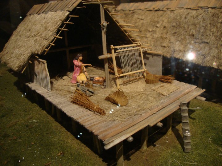
Model of a late Neolithic alpine lakeside village, based on archaeological evidence from a waterlogged settlement on the shores of Lake Constance dating to about 3200 BC.

Image credit: Chance - 2010 Model by David Provan, Ashmolean museum, Oxford
Image of Switzerland (Country) by Chance

Switzerland

Country

Model of a late Neolithic alpine lakeside village, based on archaeological evidence from a waterlogged settlement on the shores of Lake Constance dating to about 3200 BC.

Image credit: Chance - 2010 Model by David Provan, Ashmolean museum, Oxford
Image of Switzerland (Country) by Chance

Switzerland

Country

Model of a late Neolithic alpine lakeside village, based on archaeological evidence from a waterlogged settlement on the shores of Lake Constance dating to about 3200 BC.

Image credit: Chance - 2010 Model by David Provan, Ashmolean museum, Oxford
Image of Switzerland (Country) by Chance

Switzerland

Country

Model of a late Neolithic alpine lakeside village, based on archaeological evidence from a waterlogged settlement on the shores of Lake Constance dating to about 3200 BC.

Image credit: Chance - 2010 Model by David Provan, Ashmolean museum, Oxford
Image of Old Sarum (Hillfort) by Chance

Old Sarum

Hillfort

View of Old Sarum during the Neolithic period in 3000 BC showing the settled communities that had developed around the hill

Image credit: English Heritage

Three Kings Barrows

Fieldnotes – 15 September 2010

Came by this site earlier today, so stopped and had a look.

No easy way in so climbed over the hedge onto the reservoir from the road. Completely overgrown and unless you knew there was a barrow here, you would dismiss it as just a small spinney. The reservoir looks like it was built in the 1940’s and I would imagine it feeds an MOD site rather than the village of Box.
The “visible” barrow like the reservoir is very overgrown with three trees growing on top of it, a horse chestnut and two oaks, along with much elder and hazel. The mound stands about 2.5m high and about 20m in diameter. The surrounding ditch is more defined on the north east, about 5m wide and up to 0.5m deep but you cannot get a good impression of it due to the undergrowth. It would appear that this one barrow must have been twice the size of the other two, very similar to the bowl barrows found a few miles away at Colerne Park

Really needs a site visit in the depth of winter when the vegetation was died back.

Although not listed on the MAGIC website, there are a number of other round barrows within a mile of here, but the two I visited on the Kingsdown golf course were extremely reduced. Will revisit the area later in the year to get a better impression of the pre-history.