Offical record of site from the Ministry of Culture database

Chance
A group of seven carved menhirs in 8 meter diameter circle. The circle sits on top of a mound.
The stones are listed as being 2 meters tall.
The central stone is missing.
Detail listing of hundreds of sites
Offical site listing from Ministry of Culture
A traditional folklore was that girls wishing to marry should sit on the stone during the nights of full moon.
They were to do this after first noting their petticoats.
Entry for stone from the Offical Ministry of Culture database.
Interesting site from France detailing all manor of ancient sites in France, Belgium, Scotland, Ireland and Wales. (Clearly not a fan of the English).
English translation via Google.
Web site with details of the Fechain Polissor Stone, including a photo.
English translation via Google
Legend tells that if you fall asleep by the stone on a beautiful moonlit night with a gold coin tight in the palm of the right hand, you wake up rich the next day.
Web site detailing the site in the village of villers-au-Tertre. Includes photo of stone
English translation via Goggle
A polissor stone created from the local grey limestone.
Recorded as being 1.20m in height
Situated in the D132, 59234
A polissor stone created from the local grey limestone.
Recorded as being 1.10m in height by 1.70m in length.
Situated in front of the church on Rue Paul Chanteau, 59247.
A series of Bowl barrows that stretch in a line over Kingsdown ridge, over looking Box Valley.
One barrow was excavated by Shaw Mellor in 1934. Finds included calcined bone, along with the remains of more than ten human individuals, much intrusive material and a sherd from a collared urn.
Possible Iron Age sherds were also uncovered (ST 81396777)

Coate Stone Circle as seen by A.D. Passmore in 1894
Image credit: Chance after Passmore
The remaining stones of this circle, which have hitherto escaped the notice of archreologists, lie immediately in front of Day House Farm, about a quarter of a mile from the village of Coate and two miles from Swindon.They are now not at all conspicuous, as they are all lying prostrate, and at first sight they appear quite small, but on investigation with an iron bar I found that they are much larger than they appear to be, the greater portion of them being now buried under the turf, for though none of them stand more than about 18in. out of the ground, and several of them only just show above tho surface, yet stone No. 6 on the plan I found to be some 9ft. 6in. long; Nos. 3 and 5 are over 6ft.; and No. 1 is about 5ft. in length.
Stone No. 1, which lies beside the wall of the cow-shed on the western side of the road, seems to be still unbroken, though prostrate and almost buried, as are also the next three stones – 2, 3, and 4 which lie in the grass to the east of the roadway. The distance (11 ft.) between 3 and 4, I take to have been the original distance between the stones all round when the circle was complete — In which case the number of stones would have been about thirty. The circle, however, seems to have been irregular in shape, and varies in its diameter from north to south, and from east to west. As will be seen from the plan, the cow-yards and rick-yards occupy a considerable part of the site of the western side of the circle, and here only one stone is visible — No. 9, in the rick-yard—and that has been mutilated. Doubtless the others, being here more in the way, have been broken up and removed. There is a patch of old pavement of large sarsen stones and several big fragments are lying about loose. The two stones 7 and 8, in front of the house, are the smallest of all, and between-these and 6 there is a wide gap which, after hours of probing with an iron bar, I have hitherto failed to fill up. I have, however, proved that other stones once existed besides those now visible, by digging into the depression between Nos. 4
and 5, and finding in it a piece of burnt sarsen and a quantity of white ashes—probably of straw—clearly pointing to the fact that a stone standing here has been broken up.The distances between the stones are:— from 1 to 2, 75ft.; from 2 to 3, 58ft. ; from 3 to 4, 11ft. ; from 4 :o 5, 68ft.; from 5 to 6, 30ft.; from 7 to 8, 17ft.; from 8 to 9, 67ft.; and from 9 to 1, 70ft.
In the large grass field to the south west of the farm-house, which borders on the reservoir, at a distance of 18 chains from the circle already described are the three sarsen stones standing by themselves in the middle of the field, of which a plan is given. Of these the one to the eastward is a very large stone lying on its side, some 3ft. high and 7ft. long above ground. The other two are comparatively small stones, but have evidently been broken up. The distance between the stones is in each case 59ft, measuring from the outside of the stones. These stones, as they stand, have much the appearance of having formed part of a circle, but there is no sign of any other stones, or of depressions in the turf from which other stones may have been removed.
Still, an old man informs me that he remembers many large stones in this field being broken up in his early life, and he rather thinks that they stood in a circle. His evidence, however, is not sufficiently strong to build upon.
Near the stones I have found several worked flints and pottery of rude type.
By the side of the road which runs in front of Day House Farm and passes through the circle first mentioned are five stones which may possibly have formed part of an avenue. They lie in a line to the north of the circle, which, if continued, would cut through the circle and through the three stones beyond it, already described. Several of these are stones of considerable size, though only just their upper surface is now visible as they lie beside the road.
The first of these stones is near the main Swindon Road, on the east side of the Day House Road. The other four lie on the opposite side of the road, or in the ditch. The distance between the first and second is 400ft.; between the second and third, 191ft.; between the third and fourth, 65ft.; and the same distance between the fouth and fifth. I cannot find any stone nearer to the circle than this last.
It has been suggested that these stones are lying beside the road because they have been removed from the cultivated fields—
but a stone 6ft. long is such an awkward thing to move that if the only object was to get rid of them they would have been broken up rather than drawn to the roadside. The equal distances, too, between the third and fourth, and fourth and fifth stones, seem to point to their having been intentionally placed there.At the end of the reservoir, as you approach it from Broome farm, are a number of large sarsens, partly under water when the reservoir is full, some on one side of the road and some on the other. An irregular line of these seems to follow the western shore of the reservoir for some distance, but it is impossible to make out any plan, and probably they are really nothing but a natural drift of sarsens.
At Broome Farm, however, which is close by, is a field which still retains the name of Longstone Field. Here were many standing stones, until they were broken up and carried off to Cricklade. Stukeley mentions them thus:—” Longstones at Broome, near Swindon, Wilts, is a great high stone and a little way off many lesser ones in a row.”
At Hodson, about one and a half miles from Day House Farm, I have noticed a number of sarsens, which may or may not have
formed part of a circle, and from them a line of stones seems to lead in the direction of Coate.In conclusion, I must express my thanks to Mr. W. Handy, the tenant of Day House Farm, for the kind way in which he has
allowed me to explore his fields.
Notes on an undescribed Stone Circle at Coate, near Swindon.
By A. D. PASSMORE. – W.A.M. No. 27 pages 171 to 174
A Suggested use for “incense cups.”
The Society’s Museum possesses a varied and interesting series of the small vessels of burnt clay, which have, in the absence of exact information, been spoken of as ” Incense Cups.” I venture to suggest that they were used by the Ancient Britons for the very homely but impoertant purpose of containing the material—whether dried moss, dried fungus, or other kind of tinder—used in obtaining fire. They have, without exception, a pair of holes bored on one side, about half-an-inch apart. It has been suggested that these were intended for suspension ; may they not, more probably, have been the orifices through which a cord was passed to tie on the cover. An example from Lambourne, Berks, now in the British Museum, has a lid of the same ware as the cup it self, and ornamented with a corresponding pattern, and in both cup and cover there are two holes, the same distance apart, through which the string was prob»biy passed to fasten on the cover. None of these cups in the Society’s Museum have covers. It is probable that the Lambourne cup is the only one known with this appendage preserved; but lids of wood may h»ve been used, which have decayced in the progress of the centuries. It is evident that the cups could not be used for holding incense, or any other similar substance, if suspended from hoies on one side.
W. Cunnington.[A circumstance which seems to militate against Mr. Cunnington’s theory is the fact that in most cases the perforations in these little cups are not near the upper edge of the vessel, as one would fancy that they would be if the string passing through them was to serve as a hinge for the lid, but an inch or more, that is to say, one-third of the way down the side of the vessel.— WAM Ed.]
W.A.M. No. 27 pages 174 to 175
Opening of two barrows on Liddington Warren Farm, N. Wilts, 1893.
The first barrow opened is close to a green road leading from Shepherd’s Rest to Marlborough. It is a bowl-shaped barrow, and as it has been ploughed over for many years it has spread over a considerable space, its diameter from north to south being about 68ft., and from east to west 80ft., whilst its height is now only about 4ft. A trench was started on the south-east side, and at 13ft. from the centre the edge of a cairn of sarsens was reached, 3ft. in depth and built up on the original surface-level. The stones were so evenly built in that it was with difficulty that a pickaxe could be forced between them. Following these along they were found to rise within 6in. of the surface of the tumulus. When these had been removed to a depth of 4ft. the original chalk level was reached, when a cist was found in the centre full of burnt hones, on the top of which was the rim of an imperfectly burnt urn, and a small turned conical button pierced under its base in pulley fashion with a hole for the string, apparently of Kimmeridge shale, similar in shape to specimens now in the Stourhead Collection at Devizes.The second barrow lies in a ploughed field near the 6th milestone from Swindon on the Hungerford Road. It seems really to consist of two barrows joined together. A trench was dug in the eastern most of the two, beginning on the south-east side. At 3ft. from the centre the bottom of an “incense cup” was discovered, and when within 1ft. of the centre the chalk on the original surface level was found to be of a dirty brown colour and was rammed down so hard that the pickaxe would hardly enter it. On the surface of this chalk, and not in a cist, under the centre of the barrow was a heap of burnt bones. Nothing else was found.
A. D. Passmore, Swindon
W.A.M. No. 27 pages 175 to 176
John Aubrey, in his Wiltshire collections, states that this is the site of a “Druidish Temple”.
It would appear that most of the stones were removed from the site, but at least one, standing 10ft high, was recorded standing in situ during Victorian times. This stone, known as the Longstone, along with others from the area were broken up and used in the streets and footpaths of Cricklade.
In 1894, A.D. Passmore noted that the hole the Longstone stood in was still visible in Longstones Field between Coate Road and Broome Lane. A row of smaller stones was also recorded extending in a SW direction.
The Aldbourne Way
A trackway which rises steeply out of Aldbourne (SU 264 759) as a rough hollow lane and continues for a mile until it comes to (7234) Aldbourne Four Barrows (SU 249 772) set in a row. The track then continues past other barrows (SU 237 787) and Liddington Warran Long Barrow (3698), until it meets the Greater Ridgeway (SU 217 805).

Heavy butted pointed Palaeolithic handaxe of Acheulian type found on banks of River Avon, Sutton Benger
Image credit: Chance - Feb 2011

Heavy butted pointed Palaeolithic handaxe of Acheulian type found on banks of River Avon, Sutton Benger
Image credit: Chance - Feb 2011

Heavy butted pointed Palaeolithic handaxe of Acheulian type found on banks of River Avon, Sutton Benger
Image credit: Chance - Feb 2011

Neolithic polished greenstone axe found in Chippenham garden, early 1960’s
Image credit: Chance - Feb 2011

Neolithic polished greenstone axe found in Chippenham garden, early 1960’s
Image credit: Chance - Feb 2011

Practical information on visiting the Niaux cave with times, prices and local facilities

Bisons from the Black Hall (Salon noir) of the Niaux cave, replica in the Brno museum Anthropos. Magdalenian Period of Paleolithic art.
Image credit: Photo PD by HTO - Wikimedia Foundation
The Cave of Niaux is located in Niaux in the Ariège(9) département of south-western France.
Like Lascaux it contains many prehistoric paintings of superior quality, in the case of Niaux from the Magdalenian period.
From the very beginning of the seventeenth century, the cave was of great interest for tourists who left numerous traces on its walls. People, visited the cave, did not imagine that the paintings of the “Salon Noire” were so old. Only in 1906 thanks to captain Molar and his sons who made a plan of the cave and discovered the paintings of the “Salon Noire”. Niaux attracted the specialists’ attention. In 1907 it was investigated by H. Breuill and E.Cartailhac. But discovery of the “Salon Noire” paintings was only the beginning. In 1925 J. Mandeman found a gallery with some black paintings and called it Cartailhac Gallery. Later it was established that the paintings had been emerging on the cave walls during a long period between 11500 and 10500 years BC.
The main entrance to the Niaux cave used for visitors is now further up the hillside than it once was. In ancient times, there would have been several lower, smaller entrances.
The visits to the cave are strictly regulated in order to maintain an even temperature of 12 degrees C and thus preserve the wall drawings of bison, horses and ibex.
July through September there are 11 visits per day of up to 20 people with 45 minutes between each group, including a tour in English at 12:30pm. Three visits per day the rest of the year (no English tours). The caves are not lit up, visitors are handed torches, approximately 1 torch pr. 2 visitors, another measure to protect the paintings. Furthermore there is always the risk for one or two of the torches running out of battery during the visit, small children and anyone afraid of darkness should not go on this tour, once the tour has started there is no turning back. The walk to the paintings lead through both big caves and narrow passages. The cave floor has been left in its natural state: wet, very uneven and slippery in places so sturdy walking shoes are essential. It is recommended to book ahead. However, outside the ticket office a sign indicates how many spaces are left (if any) in the day’s scheduled tours. If you arrive in the morning you might be able to reserve a spot in a tour in the afternoon. But don’t count on this in July and August.
Details of the Cosquer Cave by Jean Clottes, Jean Courtin, Luc Vanrell
A three-dimensional reproduction of the cave created by Electricité de France, permitting a “virtual visit”.
The Cosquer cave is located in the Calanque de Morgiou near Marseille, not very far from Cap Morgiou, in the Bouches-du-Rhône Department(13).
The entrance to the cave is located 37 meters underwater, due to the rise of the Mediterranean in Paleolithic times.
It was discovered by diver Henri Cosquer in 1985, but its contents were not made public until 1991, when three divers became lost in the cave and tragically died.
Today, the cave can be accessed through a 175 meters (574 ft) long tunnel, the entrance of which is located 37 meters (121 ft) below the surface of the sea, because of changes in the relative altitudes of land and sea.
The ancient corresponding shore of Mediterranean sea was then several kilometers away and below as measured from the cave mouth. Sea surface was lower and land altitude higher because large volumes of water were retained in enormous icecaps, making the level of the sea 110 to 120 meters (361 to 394 ft) lower than today, affecting Mean Sea Level as calculated for aproximately 20,000 years ago during the peak of the last major glaciation (Würm glaciation).
The unique feature of this cave is that it contains several dozen works painted and engraved between 27,000 and 19,000 years ago. It is decorated with a variety of land animals, but also with seals and auks, fifty-five hand stencils, and numerous digital markings, dozens of geometric symbols, as well as the extraordinary representation of a “slain man”.
In order to protect this exceptional site, but also for safety reasons, the cave is closed to the public.

Outline of a human hand, dated 27,000 Before Present Era, displayed at the Musée d’Archéologie Nationale (Museum of National Archeology), in the Chateau of Saint-Germain-en-Laye, Paris, France.
Image credit: Photo PD by SiefkinDR - Wikimedia Foundation
Werner Herzog gains exclusive access to film inside the Chauvet caves of southern France, capturing the oldest known pictorial creations of humankind in their astonishing natural setting.
He puts 3-D technology to a profound use, taking us back in time over 30,000 years.
Includes trailer for the movie
Offical French Ministry of Culture information site in English
Includes an interactive map with photos.
An enthusiast web site by Don Hitchcock from Armidale NSW, with some excellent photographs and articles on the caves and the area

The Chauvet horses by Cro-Magnon peoples 31000 BP (Aurignacien)
Image credit: Cro-Magnon peoples 31 000 BP (Aurignacien) - Photo PD by Wikimedia Foundation
The Chauvet-Pont-d’Arc Cave is a cave in the Ardèche department (7) of southern France that contains the earliest known cave paintings, as well as other evidence of Upper Paleolithic life. It is located near the commune of Vallon-Pont-d’Arc on a limestone cliff above the former bed of the Ardèche River.
Discovered in 1994, it is considered one of the most significant prehistoric art sites.
The cave was first explored on December 18, 1994 by a group of three speleologists: Eliette Brunel-Deschamps, Christian Hillaire, and Jean-Marie Chauvet, for whom it was named.
On top of the paintings and other human evidence they also discovered fossilized remains, prints, and markings from a variety of animals, some of which are now extinct. Further study by French archaeologist Jean Clottes has revealed much about the site, though the dating has been the matter of some dispute.
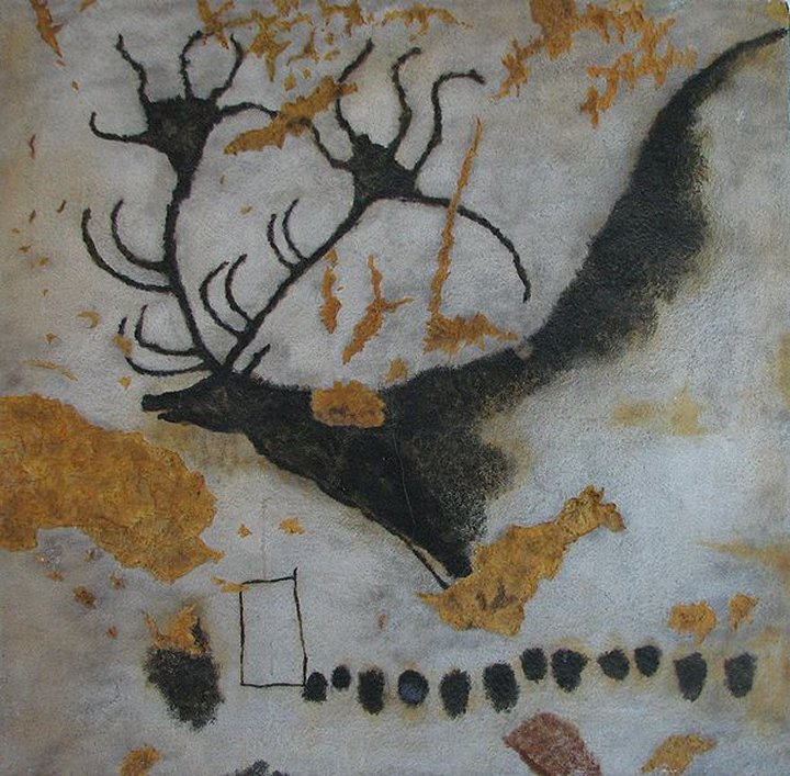
Megaloceros, painting of the Giant Deer from Lascaux
Image credit: Cro-Magnon peoples - Photo PD by HTO Wikimedia Foundation

Cave painting of a Buffaloes at Lascaux
Image credit: Cro-Magnon peoples - Photo PD by Prof Saxx Wikimedia Foundation

Cave painting of a dun horse (equine) at Lascaux
Image credit: Cro-Magnon peoples - PD from Wikimedia Foundation
Official Web site from the French Ministry of Culture – English version
Official website of the International Committee for the Preservation of Lascaux
Lascaux is the setting of a complex of caves in southwestern France famous for its Paleolithic cave paintings. The original caves are located near the village of Montignac, in the Dordogne département. They contain some of the best-known Upper Paleolithic art. These paintings are estimated to be 17,300 years old. They primarily consist of primitive images of large animals, most of which are known from fossil evidence to have lived in the area at the time. In 1979, Lascaux was added to the UNESCO World Heritage Sites list along with other prehistoric sites in the Vézère valley.
The cave was discovered on September 12, 1940 by four teenagers, Marcel Ravidat, Jacques Marsal, Georges Agnel, and Simon Coencas, as well as Marcel’s dog, Robot. The cave complex was opened to the public in 1948. By 1955, the carbon dioxide produced by 1,200 visitors per day had visibly damaged the paintings. The cave was closed to the public in 1963 in order to preserve the art. After the cave was closed, the paintings were restored to their original state, and were monitored on a daily basis.
Rooms in the cave include The Hall of the Bulls, the Passageway, the Shaft, the Nave, the Apse, and the Chamber of Felines.
Lascaux II, a replica of two of the cave halls — the Great Hall of the Bulls and the Painted Gallery — was opened in 1983, 200 meters from the original.
Reproductions of other Lascaux artwork can be seen at the Centre of Prehistoric Art at Le Thot, France.
Since 1998 the cave has been beset with a fungus, variously blamed on a new air conditioning system that was installed in the caves, the use of high-powered lights, and the presence of too many visitors.
As of 2008, the cave contained black mold which scientists were and are still trying to keep away from the paintings.
In January 2008, authorities closed the cave for three months even to scientists and preservationists. A single individual was allowed to enter the cave for 20 minutes once a week to monitor climatic conditions. Now only a few scientific experts are allowed to work inside the cave and just for a few days a month but the efforts to remove the mold have taken a toll, leaving dark patches and damaging the pigments on the walls.

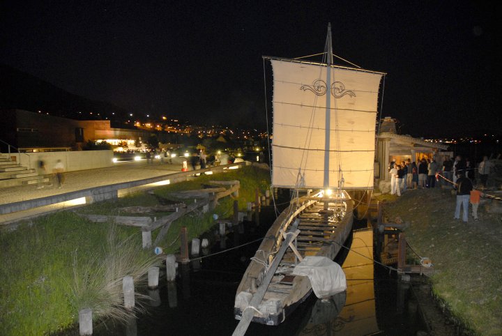

Offical website for the archeology museum with events diary
The Laténium is an archeology museum located in Hauterive, a suburb of Neuchâtel in the Swiss Canton of Neuchâtel, on the shore of Lake Neuchâtel.
Its name refers to the La Tène culture.
The Laténium is composed of a 2500 m² park, and a museum building which also houses the archaeological section of the University of Neuchâtel.
The park features dolmens and erratic stones, reconstitutions of prehistoric and antique devices (a La Tène house, a gallo-roman ship and a Celtic bridge, notably), and modern works of art. The museum displays the Bevaix Boat, a 20-metre gallo-roman ship found in Bevaix.
Items from periods comprised between the paleolithic to the Roman empire are on display, including the remains of a Magdalenian hunting camp.
Stonehenge Winter Solstice 2010
Video showing the Altar stone being used as the site of a pagan Handfasting or hand-festa.
For more on this see themodernantiquarian.com/post/69318/folklore/ringstone-or-handfasting-stone
The naming of the Altar Stone is due, apparently, to Inigo Jones, who made the first ‘plan’ of Stonehenge in 1620, although the real purpose of the stone is entirely unknown.
The Altar Stone, which is a fine-grained pale green sandstone, is not from the Prescelly Mountains of Pembrokeshire, the source of the of the blue stones, but from the Cosheston Beds (a division of the Old Red Sandstone of South Wales) which crop out on the shores of Milford Haven, further south in the same county.
No other stone composed of this rock is known at Stonehenge, though occasional fragments of it, very probably detached from the Altar Stone itself, have been found in the soil of the site.
Significantly, chips of an entirely different grey-green micaceous sandstone have also been collected on the site, and have been identified with a particular outcrop of the Cosheston Beds at Mill Bay on the south shore of Milford Haven, about 2.5 miles above the ferry at Pembroke Dock.