White Cairn, Markdhu
markj99
White Cairn, High Aires
White Cairn, Laggish
White Cairn, Barrhill
Crouse Hole Stone
White Cairn, Crouse
White Cairn, Bargrennan Burn
White Cairn, Clatteringshaws
White Cairn, Gelston
White Cairn, Fleuchlarg
White Cairn, West Skelston
White Cairn, Honeyhole
Drumwhirn Cairn
Barclye Cairn
Laganabeastie West Cairn
Laganabeastie East Cairn

Laganabeastie Cairns, East (left background) & West (centre foreground).
Image credit: Mark Johnstone


Scattered Stones on robbed out S side of Laganabeastie East.
Image credit: Mark Johnstone

Excavated hollow on SW quadrant of Laganabeastie East
Image credit: Mark Johnstone

Laganabeastie Cairns, East (left background) & West (centre foreground).
Image credit: Mark Johnstone


Exposed stones on Laganbeastie West cairn summit.
Image credit: Mark Johnstone

Laganabeastie East from Laganabeastie West Summit.
Image credit: Mark Johnstone
Laganabeastie Cairns can be found adjacent to the single track road to Lagafater Lodge, a large isolated holiday house in Dumfries and Galloway. The East & West cairns are located only 50 yards apart on the edge of moorland separated by a dry stane dyke.
Scant details of Laganabeastie East are available on Canmore ID 61900 (go to Links). It is described as “ a cairn, measuring 17.3m in diameter and 1.5m in height”.
The cairn has been heavily robbed on the S side leaving an excavated hollow and scattered stones behind. It measures approximately 20 yards on the EW axis by 2 yards high. It is still recognisable as a cairn despite the desecrations.
Directions: Take the un-signposted single track road 400 yards N of the Innermessan Junction on the A77 to Stranraer. Continue for 5 miles across moorland until you reach Penwhirn Reservoir and Filter Station. Take the next L across a bridge just after the Filter Station. This is a dead end single track road leading to Lagafater Lodge. Follow this narrow road for 2.5 miles until you reach an exposed stone bridge. Park in the next passing place. The Laganabeastie Cairns can be seen on the R in a rough pasture surrounded by a dry stane dyke. If you reach a Private Road sign you have gone too far. Turn around and the cairns will be on your L after around 500 yards.
Laganabeastie Cairns can be found adjacent to the single track road to Lagafater Lodge, a large isolated holiday house in Dumfries and Galloway. The East & West cairns are located only 50 yards apart on the edge of moorland separated by a dry stane dyke.
Laganbeastie West is an undisturbed cairn listed as Canmore ID 61881 (go to Links). It is around 20 yards EW axis by 2 yards high , however, it is covered in grass with stones only visible on the summit. It’s possible that Laganabeastie Cairns East & West would been twins in the prehistoric landscape.
Directions: Take the un-signposted single track road 400 yards N of the Innermessan Junction on the A77 to Stranraer. Continue for 5 miles across moorland until you reach Penwhirn Reservoir and Filter Station. Take the next L across a bridge just after the Filter Station. This is a dead end single track road leading to Lagafater Lodge. Follow this narrow road for 2.5 miles until you reach an exposed stone bridge. Park in the next passing place. The Laganabeastie Cairns can be seen on the R in a rough pasture surrounded by a dry stane dyke. If you reach a Private Road sign you have gone too far. Turn around and the cairns will be on your L after around 500 yards.

Excavated trench on Barclye Cairn viewed from SSE.
Image credit: Mark Johnstone


Barclye Cairn earthfast stones viewed from ENE, possibly remnants of a cist.
Image credit: Mark Johnstone
Visited 11.07.20
Barclye Cairn is described in Canmore ID 62933 (go to Links). It is a robbed out cairn 20m across by 1.5m high. There are two earthfast stones which may be the remnants of a cist.
Directions: Take the A75 turn off to Newton Stewart at the large roundabout. Follow the town centre to the end of Victoria Street & bear left across the Cree Bridge. Turn L about 50 yards from the end of the bridge into Minnigaff. After 0.5 mile you will see a war memorial on your R.
Take the next L turn after 100 yards. This is a narrow country lane headed to Cree Woods. Follow this lane past Minigaff Parish Church, Boreland Wood and Boreland Farm. Around 0.75 mile after Boreland Farm there is a gate at NX 389 686 (approximately) on the R. There is limited parking here so I chose to go onto Barclye Wood Parking (NX 38604 69482) around 0.5 miles along the lane.
Having walked back to the gateway, I headed N up a slope for 300 yards to a hilltop where Barclye Cairn is prominent.
Drumwhirn Cairn & Barclye Cairn are close together so they can easily be achieved in the same trip.
Visited 11.07.20
Directions: Take the A75 turn off to Newton Stewart at the large roundabout. Follow the town centre to the end of Victoria Street & bear left across the Cree Bridge. Turn L about 50 yards from the end of the bridge into Minnigaff. After 0.5 mile you will see a war memorial on your R.
Take the next L turn after 100 yards. This is a narrow country lane headed to Cree Woods. Follow this lane past Minigaff Parish Church, Boreland Wood and Boreland Farm. Around 0.5 mile after Boreland Farm a green lane protected by a deer gate starts at NX 39089 68355 on the R. There is limited parking here so I chose to go onto Barclye Wood Parking (NX 38604 69482) around 0.5 miles along the lane.
Having walked back to the green lane I found the gate immovable so I had to climb the high style beside the gate. Follow the green lane uphill for 300 yards, bearing R at a fork then reach another deer gate 150 yards later. I opened this gate with some difficulty (it was heavy and stiff) and followed the field perimeter NE for around 150 yards to another deer gate. Look L to see Drumwhirn Cairn, a significant pile of stones in the adjacent field around 300 yards away. After another deer gate workout there is a stream to cross on stepping stones before reaching the field. Drumwhirn Cairn is impressive on approach however closer inspection shows significant stone robbing. The summit has been excavated leaving a dirt filled hollow behind.
Drumwhirn Cairn is on a highpoint with extensive views all round. It is around 30 metres across and 5 metres high. It must have been spectacular before Man started messing with it.
Further details of Drumwhirn Cairn can be found at Canmore ID 62929 (go to Links).
Drumwhirn Cairn & Barclye Cairn are close together so they can easily be achieved in the same trip.

Approaching the Two Eggs, erratic boulders on Morton Moor
Image credit: Mark Johnstone

N Egg, viewed from N, pictured with a c. 1m walking stick for scale.
Image credit: Mark Johnstone

S Egg, viewed from NE, pictured with a c. 1m walking stick for scale.
Image credit: Mark Johnstone
Visited 21.01.09
I have little memory of this visit except for the seemingly endless bleak moorland, however I have submitted pictures of both Eggs.

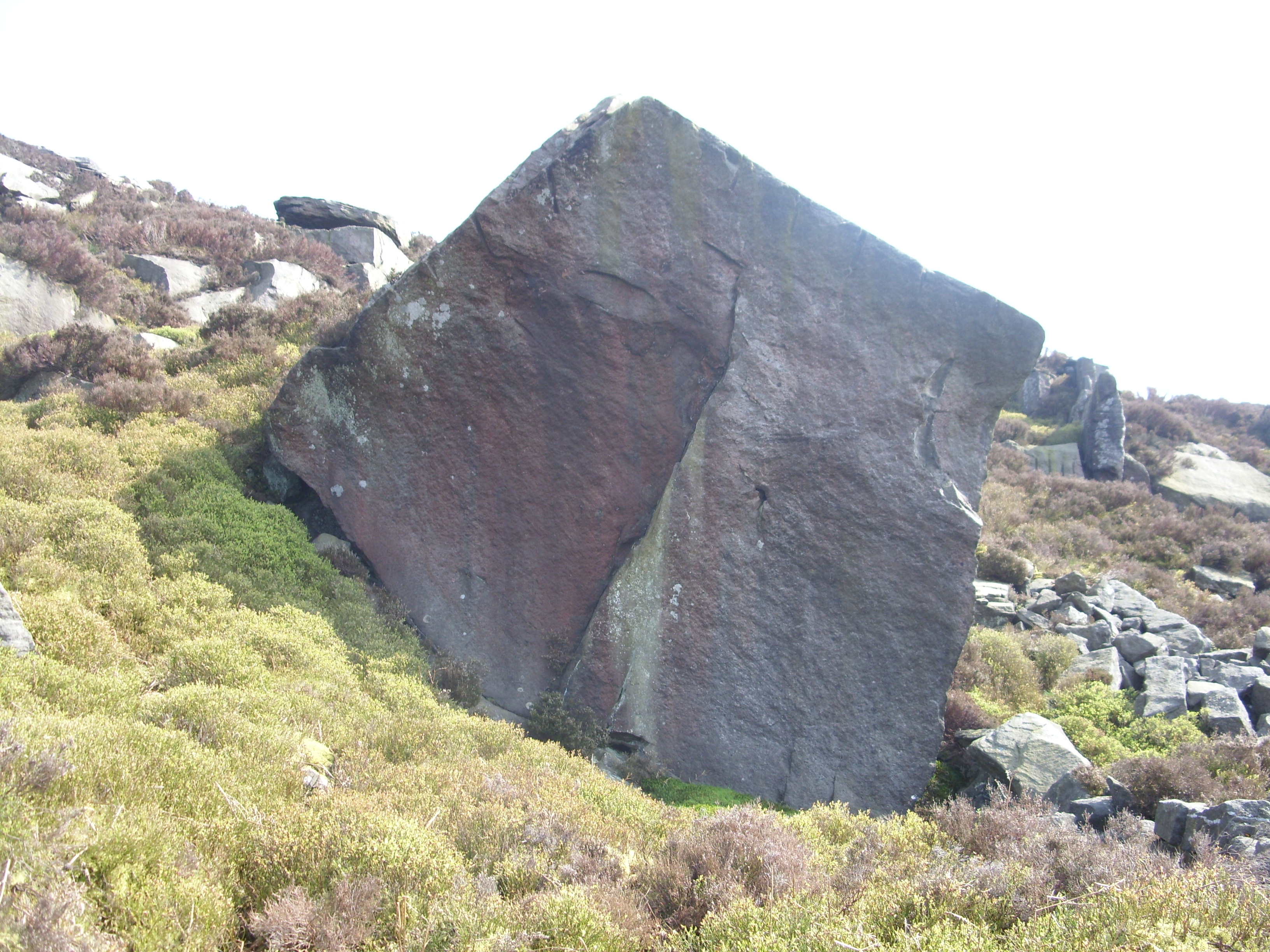
Approaching the Fairy’s Chest from SW.
Image credit: Mark Johnstone

Visited 17.04.09
There is a Car Park at Embsay Reservoir. Follow the road NW, parallel to Embsay Reservoir towards Crookrise Wood. Go straight on at the end of the road following the path N rather than an obvious track E. The path veers NW towards the corner of the wood and follows NW between the moor and the wood. After nearly 1 mile you will reach the Trig Point of Crookrise Crag. The Fairy’s Chest lies 300 yards further up the path, on the slope of the moor. It is a large cuboid erratic which looks like it has been shaped by man not nature. It measures approximately 10m x 3m x 3m and has unusually flat surfaces. There are several other large stones around it however the flat top will give it away.
Visited 06.07.19
White Cairn, Honeyhole is a grassy cairn, 3.5 miles WNW of Thornhill. It lies in an elevated field above Honeyhole farm.
Canmore ID 65238 (go to Links) states it “survives as a partly turf-covered stony mound 32.5m E-W by 29.5m and up to 1.7m high with no significant features.”
Nothing has changed since the 1977 survey. The flat field contrasts with the cairn’s modest elevation. Some scattered small stones are visible amongst a grassy thatch.
Directions: take the Sanquhar road off the A702 in Penpont. After two miles bear L for Scar Water. After 0.5 mile you will reach Honeyhole farm. Continue for c. 300 yards to a gateway on L with space to park. Head uphill SW, towards the corner of the wood. After 300 yards climbing steeply cross into the adjacent field. Walk SW for another 200 yards to reach White Cairn, Honeyhole.


Original stones with an aged white patina on White Cairn, West Skelston.

Visited 28.08.19
White Cairn, West Skelston is a partially robbed cairn, reused as a dump for field clearance stones and old farm equipment. It is 3 miles W of Dunscore in an arable field overlooking West Skelston farm.
Canmore ID 65098 (go to Links) describes the cairn in 1991 as follows: “This cairn is situated on the crest of a spur and measures 23m in diameter and 3m in height; it has been partly robbed and has been supplemented by large boulders relatively recently.”
There are original stones with an aged white patina but there are also a large central robbed out void, large field clearance stones and some old farm equipment on this cairn.
This seems to be the fate of cairns in proximity of farms where the temptation to exploit a natural resource is too great.
Visited 07.04.12
Fleucharg Long Cairn has certainly been abused over the millennia, most probably in the last centuries. However, it is still a significant presence in the landscape worth visiting.
It was archaeologically excavated in 1937. Canmore ID 65063 (go to Links) states it “measures 150 ft NNE-SSW by 44 ft across the N end and 85 ft some 25 ft from the S end, and has a maximum height of 14 ft.”
Of particular note was “a setting of three boulders, possibly part of a kerb” according to Canmore ID 65063.
There are also large voids in the cairn due to stone robbing.
It is identified as White Cairn in OS 1:50k maps.

The three remaining stones of White Cairn, Gelston viewed from S. Rather underwhelming.
White Cairn, Gelston was a cairn 1 mile W of Gelston, a small community near Castle Douglas.
Canmore ID 64467 (go to Links) says the “remains of this cairn consist of two large stones set in line east to west with an indeterminate scatter of small stones to the south. The west stone is 3.0m long by 0.6m wide and 1.0m high, the other being approx half this size.” This entry dates to 1968 and things have changed since then. On 14.09.19 two large stones corresponding to the 1968 entry were piled in the corner of a field with an old tyre at the expected grid reference. There is a third small stone beside the pair of stones but the scattered stones have been removed. The destruction of the cairn has been completed. The remaining two large stones were thought to have been part of the cist originally.
It was more of a practical exercise to find the site of the destroyed cairn than a walk to an existing cairn.

White Cairn, Clatteringshaws hidden in its private pine enclosure.

A pile of moss covered stones, some of the remains of White Cairn, Clatteringshaws.