White Laise Cairn is located c. 0.5 mile W of Loch Doon Caravan Site in open moorland in East Ayrshire. It slopes gently from N to S. There is a scattering of small stones in the centre of the cairn, many of then having a white patina. A shepherd’s cairn, c. 3 feet high, has been erected in the SE quadrant of the round cairn. The grassy perimeter is delineated by a ring of ferns. The cairn measures c. 3 feet high by 45 feet in diameter.
Canmore ID 42618 has further details of White Laise Cairn. There are no traces of the stone structure on the N Arc mentioned in Canmore.
Directions from N: Take the A713 Dalmellington turn off the A77 Bankfield Roundabout on the edge of Ayr. Head through Dalmellington to Carsphairn. After c. 22.7 miles take the B729 Moniaive turn off the A713 on the E edge of Carsphairn. Stay on the B729 for c. 5.2 miles to reach Smittons Farm. Take the left turn cul-de-sac signed for Water of Ken. Follow this single track for c. 1.8 miles to park up at the junction with Craigengillan. My walking route is viewable on Craigengillan Cairn.
Directions from S: Take the A76 Kilmarnock turn off the Cuckoo Bridge Roundabout on the A75 at Dumfries. After c. 1.8 miles take the left turn for B729 Moniaive. (There is parking for The Twelve Apostles of Hollywood c. 450 yards from the junction on the left. This large stone circle is a must see). Take the B729 for c. 13.5 miles to Moniaive. Follow the B729 through Moniaive for c. 10 miles to reach a left turn cul-de-sac for Water of Ken. Follow this single track for c. 1.8 miles to park up at the junction with Craigengillan. My walking route is viewable on Craigengillan Cairn.


Visited 17.09.24
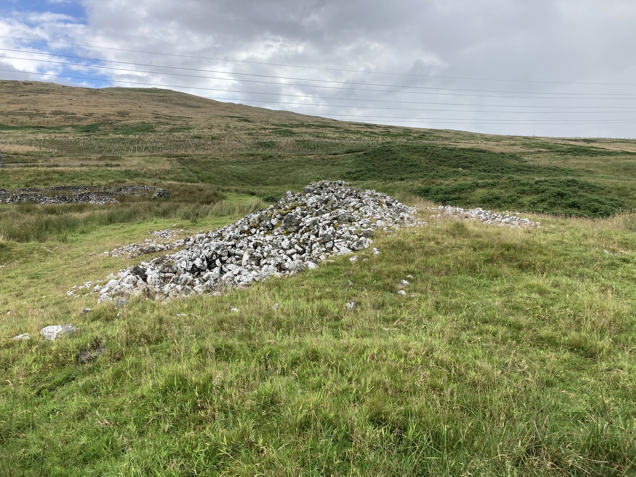
Craigengillan Cairn is a ruined cairn, hidden in forestry c. 4 miles ENE of Carsphairn in Dumfries and Galloway. Despite its isolated location, this cairn has been badly treated by Man. The surface of the cairn has been entirely stone-robbed. Subsequently, a sheep ree consisting of three substantial walls was constructed on the mound. The area around the cairn was ploughed prior to afforestation. Deforestation was the final indignity, leaving the cairn surrounded by an area of devastation.
According to Canmore ID 64336 the circular mound measured c. 80 feet in diameter and 10 feet high in 1911. The diameter may have been reduced by the encroachment of trees. The grassy surface of the cairn is still intact, subdivided by three surmounted walls radiating from the summit.
Stout Footwear and GPS Navigation are essential to find this cairn. The last 0.4 mile is through boggy difficult terrain in a forest. Retrace your steps carefully: I took a wrong turn and had to exit by following a burn down to the road.
Directions from N: Take the A713 Dalmellington turn off the A77 Bankfield Roundabout on the edge of Ayr. Head through Dalmellington to Carsphairn. After c. 22.7 miles take the B729 Moniaive turn off the A713 on the E edge of Carsphairn. Stay on the B729 for c. 5.2 miles to reach Smittons Farm. Take the left turn cul-de-sac signed for Water of Ken. Follow this single track for c. 5.2 miles to park up at the junction with Nether Holm of Dalquhairn Farm. My walking route is viewable on Nether Holm of Dalquhairn Cairn.
Directions from S: Take the A76 Kilmarnock turn off the Cuckoo Bridge Roundabout on the A75 at Dumfries. After c. 1.8 miles take the left turn for B729 Moniaive. (There is parking for The Twelve Apostles of Hollywood c. 450 yards from the junction on the left. This large stone circle is a must see). Take the B729 for c. 13.5 miles to Moniaive. Follow the B729 through Moniaive for c. 10 miles to reach a left turn cul-de-sac for Water of Ken. Follow this single track for c. 5.2 miles to park up at the junction with Nether Holm of Dalquhairn Farm. My walking route is viewable on Nether Holm of Dalquhairn Cairn.

Nether Holm of Dalquhairn Cairn viewed from N.

Nether Holm of Dalquhairn Cairn viewed from E.

Nether Holm of Dalquhairn Cairn viewed from S.

Nether Holm of Dalquhairn Cairn viewed from W.

Interior of Nether Holm of Dalquhairn Cairn viewed from N.
Visited 17.09.24
Nether Holm of Dalquhairn is a ruined cairn c. 7 miles NE of Carsphairn in Dumfries and Galloway. It is located in a grass field c. 250 yards SE of Nether Holm of Dalquhairn farm. The round cairn has been badly treated: First of all, it was almost completely robbed of stone, then it was enclosed in a stone wall and finally trees were planted on the perimeter of the cairn. These trees are now mature, delineating the original cairn. There is an intermittent grass bank up to 3 feet high within the stone wall, possibly defining the original extent of the cairn. The centre is a grassy hollow, largely free of trees and vegetation. No stones are visible on the surface of the cairn. Canmore ID 64319 has details of Nether Holm of Dalquhairn Cairn.
On my visit, I bumped into the friendly farmer who was happy for me to go to the cairn since there were only a few lambs in the field.
Dolmen de Kerroc’h on Google Maps

Dolmen de Kerroc’h viewed from N.

Dolmen de Kerroc’h viewed from E.

Dolmen de Kerroc’h viewed from S.

Dolmen de Kerroc’h viewed from W.
Visited 18.09.23
Dolmen de Kerroc’h is around 1.2km south of Plouharnel in the hamlet of Kerroc’h. It is located on a patch of grass in the centre of Kerroc’h. The naked dolmen consists of a massive capstone leaning west at 30 degrees, propped up by two large orthostats in the northwest and southwest corners. The sub rectangular capstone measures around 4m by 3m in length. A large recumbent stone lies around 2m east of the dolmen.
Directions: Take the Rue de Kerhueno (Stop Andouilles) turn off the D781 between Carnac and Plouharnel. Follow the road for around 0.75km to reach a stop sign. Turn left for 150m to reach Dolmen de Kerroc’h. Nearby street parking is available and access is free.
Directions to Knockeen Cairn from N: Head for Barr Village in South Ayrshire. Turn left onto Glenginnet Road at the dead end sign. Stay on the narrow road for c. 4 miles to the end of the road. Turn right for Glentrool/Newton Stewart. Stay on this single track road for c. 1.5 miles to reach a car park on the right at NX 3412 9371. Head E through the gate for Pinbreck Hill. There is no path so make your best way upwards through rough boggy ground, heading E towards the cairn on the summit. My route is viewable on Pinbreck Hill Cairn.
Directions to Knockeen Cairn from S: Head for Newton Stewart town centre. At the end of Victoria Street head straight on for Girvan A714. Follow this road for c. 8.5 miles to the Glentrool junction. Take the right turn to Glentrool. Stay on this road for c. 8.4 miles to Rowantree Toll. Bear left onto the cycle route for Carsphairn/Ayr. Follow this single track road for c. 2.3 miles to a car park on the left at NX 3412 9371. Head E through the gate for Pinbreck Hill. There is no path so make your best way upwards through rough boggy ground, heading E towards the cairn on the summit. My route is viewable on Pinbreck Hill Cairn.
Directions to Knockeen Cairn: Head for Barr Village in South Ayrshire. Turn left onto Glenginnet Road at the dead end sign. Stay on the narrow road for c. 2.6 miles to reach a farm track at NX 3079 9570, c.130 yards W of Knockeen Farm. Park up and follow the farm track SW along the margin of the field towards the E end of the trees. Knockeen Cairn is located adjacent to the SE corner of the trees. My route is viewable on Knockeen Cairn.


Directions to Cairnennock Cairn: There is a lay-by c. 200 yards N of Eriff Farm on the A713. Walk S towards the farm to a track leading W round Loch Muck. Follow the track for c. 0.4 mile to reach a sheepfold. Head W up the moorland for 0.25 mile towards a stone cairn appearing on the horizon. My route is viewable on Cairnennock Cairn.
Visited 28.07.24
Cairnennock Cairn is situated on Little Eriff Hill, c. 500 yards N of Loch Muck in East Ayrshire. According to the Name Book, it was previously known as the White Cairn of Carnannock. This was probably due to the extensive growth of lichen on the cairn stones which give it an air of antiquity. The cairn is surrounded by a ring of boggy ground up to 10 feet wide populated by marsh grass. Canmore ID 43500 estimates that the sub-circular mound measures 20m E-W by 18m N-S. It was robbed for the construction of a now ruined sheep ree. A central corridor c. 6 feet wide has been razed to ground level in the E-W axis. There are remains of a low wall in the W arc. The N half has a marker cairn c. 5.5 feet high on the perimeter and the S half reaches up to 3 feet high.
Directions to Lagwine Cairn: There is a parking lane SW of the A713 at NX 5572 9439, c. 0.7 miles N of Carsphairn. Cross the road and follow the track to Bridge End cottage. There is pedestrian access through a locked gate. Follow the track N for c. 40 yards then turn right onto a track heading SE. Follow this track for c. 0.45 mile to the third pylon. Skirt past the pylon to a gate into rough pasture. Head NE on rough terrain for c. 150 yards to the stony cairn. My route is viewable on Lagwine Cairn.
Directions to Duniewick Hillfort: Take the B7044 Colmonell turn off the A77 on the S end of Ballantrae. This road is narrow with very few passing places. Follow the road for c. 2.8 miles to reach Finnart Cottage. There is a muddy parking space c. 50 yards E on the left side. Knockdolian path starts c. 30 yards E from here. The path climbs steeply NW up a field towards a gate which leads to Knockdolian summit ridge. Walk N past the gate following the fence line into rough pasture. Duniewick Crag is visible NW from here. Head W towards a dry stane dyke then follow the dyke N for a gate in the NW corner of the field. A rough track starts here heading clockwise round the crag. A steep ditch starts in the SW corner of Duniewick Crag. Follow the ditch to the centre of the W flank where an angled rock slab provides a path up to the summit plain of Duniewick Hillfort. My route can be viewed on Duniewick Hillfort.