


A Coflein relieved blue spot yielded this standing stone.
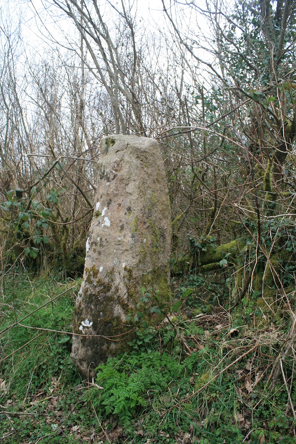
This is said to be one of the seven standing stones referred to in the name Clym Saith Maen (see NPRN 304064). It is a 1.4m high monolith, apparently decapitated.
I tried really hard to see this stone from the road, I wasn’t going to wander around the boggy gorse ridden marshes without being able to see my destination, I made four passes at it but it remained aloof.
A better map shows the stone by a fence on the border between farmland and rough national park.
Next time.
The coflein entry says it is one of seven, as does the sites name, but I can only see six on the map and coflein, where could it have gone, or does it still lurk in some nearby hedgerow.
Next time.

Looking over Carn Menyn cairn to Carn Arthur.

looking over the big capstone to watch the stone river run its way to the stone sea.

Some kind of stone walling behind the cairn.


Inside the collapsed chamber.

Carn Menyn overlooks the cairn of the same name.

The stone river has at its head, spring like, Carn Menyn chambered cairn.

From near Bedd Arthur, the cairn is immediate right of the X.

After erupting out of the west side of the Carn Menyn chambered cairn the stone river curves south and like all good rivers goes down hill.


From a road somewhere to the south of the fort.
New boots, new car, new hill fort.
I saw this on the map once but all it was described as was enclosure, I secretly hoped it was a henge, it looked very circular on google earth, it was still a long shot for sure, coflein crushed my hopes and gave me something to go for at the same time, it wasn’t a henge, but it was a defended enclosure or hill fort. I like hill forts, especially ones in North Wales.
Coflein describe it thus.....Remains of a large Iron Age defended enclosure, comprising a double banked sub-circular enclosure, c.76m in diameter, c.114m overall diameter. Probably ploughed-out on the east side leaving the semicircular earthworks which survive today.
We parked at the south west of the fort, by a T junction. The first of four stiles takes us from the road to the first field, the fourth stile takes you to a bridge over a stream in a gorge, where courting Buzzards circle overhead. Then take the overgrowing path up the other side of the gorge, until you com,e next to a wide green field, jump the fence and go up the hill, the fort is inevitably at the top.
Upon reaching the top the first part of the fort we get to is the southern end of the great C, I call it the great C in effigy of The U of Stemster, the fort is ploughed out and away on the east side leaving the large C shaped earthworks we have with us today. The Great C of Bontuchel, will it catch on do you think.
We enter the ditch, over a very low earthwork that shores up this end of the fort, is it original or just part of the destruction, it’s a nasty term destruction, but if they laid a bypass through your kitchen it would feel pretty destroyed.
But what is left is a pleasure to behold, two banks and ditches, both high and low, best preserved at the south west. The trees lend an airy atmosphere, and hide you from prying farmers eyes, for they all have such eyes, and they shout too much.
At the west end of the great C is a very slight entrance, cant tell if it’s modern or not though. Also an old low wall runs right by right up against the fort, making it look like an additional bank of the fort.
Reaching the end of the fort, at the top, it just runs out and is replaced by a hedge, fade to grey.
I quickly march over to the other end of the field for a wider shot of the whole place, it looks good framed against the Clwydian range and all it’s hill forts.
Fab place.


The deepest part of the ditch, maybe seven feet deep.


On the north side of the great C the banks are lower and the ditch not as deep.


This place is one of the oldest voices in my head, mental ? me ? maybe, the name Broomrigg has been in the old noggin for well over a decade, places I haven’t been too, things I haven’t seen, press on me, they play on my mind, the only way to quell the clamour of sites demanding my attention is to go there. To find a site, requires many things to come together all at once, this was that day, this equinox day out ticks many boxes, and butters many parsnips. Start with sunrise at Mayburgh henge, the entrance faces east, then King Arthur’s round table, then north to here, Broomrigg, and then on to Grey Yauds. A three in one (Holme head standing stone being a bonus site) day out, calm please, I’ll get round to you all eventually, I wonder if the ancients, or anyone nowadays feels they have a one to one relationship with a site, it’s like finding a long lost relative, you’d go a long way to get there, and be sad to leave, and it might even be just a once in a lifetime event. You’ve still got to go.
I parked in the wide entrance to the forest, leaving my eldest on her i wotsit, Eric, his mate Luke and myself entered the Broomrigg plantation. We followed the path until we could see the wall, immediately before it is a small kerb circle, Burls Broomrigg B. One large stone coerces three smaller stones into a curve, only half the circle survives.
Then following the wall north, Broomrigg A appears amid the trees on our left, well I say our, the kids are off exploring this new playground and i’m left to find, count and photograph the five or six stones, , it’s all part of the ritual of meeting new kin. Photography was hard all day though, I might have got the camera a tad wet when I went Wales earlier in the week now it wont auto focus.
But miraculously it’s now fixed itself so I’m a happy bunny again.
Back to where the path and wall meet, and on the other side of the wall, south of the path, I was looking for Burls Broomrigg D, The Wallmoor ring. I did find some stones, large and vaguely circular, I wasn’t totally convinced until rereading Burls description when I got home.
Back to the path once more, back to Broomrigg B. Across the path from B and on a bit is a fallen standing stone, apparently. But further south into the trees brings one to a clearing, within it is the remains of a large cairn circle, Broomrigg C, in my mind a very ruinous version of Glassonby.
This was my favorite site in the forest, the sun shone down, the noisy boys had returned to the car, the stones, oooh, could be as many as ten, were large and obvious and it was altogether more to with it than the other circles.
The only thing I didn’t find was the henge, I didn’t bring Burls “indispensable” guide book, nor did I bring my compass even if I did know which way to go. One is often ill prepared to meet long lost ageing family. Bless.
I liked it here, it is a good place, despite forest interiors having no views.
From Newbiggin, head west on a dead straight road and park at the T junction, there’s enough room for a couple of cars to squeeze onto a grass verge.
From this vantage point you cant see the stone, but if you can see the field with a small quarry at the bottom of it, then this is the field you want to be in as you get to the top of the hill.
As I climb the hill, i’m acutely aware that this isn’t following a footpath, so I try and get out of plain site as quick as I can, At the top of the hill a field wall bars the way a gate in the left corner is open so here is my point of entry. The stone and myself are now in the same field but because of it’s being in the far corner I still cant see it. I’m almost on top of it now, but still nowt, I begin to wonder if ive got my wires crossed somehow. Then right there before me, in the bottom of a natural dip in the landscape is the stone, King Harry’s stone.
Cows from the next field come over for a bit of a moo at me over the wall, I sit down on the other side of the stone and they soon lose interest.
A bit of a strange place this, the land is lifted in the air so it cant be seen from below, but further east and the ground rises further still, Thack moor has a sprinkle of snow upon its crown. But why in this dip here, almost invisible from just twenty yards away. But then this is no solitary standing stone, it’s an outlier to a now lost stone circle, not one stone remains, except this outlying stone, King Harry’s stone. One wonders where exactly in relation to this remainder was the circle, my guess would be south of it, there’s a big open space, but so to is there one to the north, just not east or west.
What a shame it’s all gone, but then this one remainder is still worth the fifteen minute walk up hill. Come, and feel sorry for it, but, applaud it’s survival.
This standing stone is very close to the road, there’s just enough room between the road and stone to squeeze a railway track in, so they did. How rude.
So I had to turn round and park near the bend in the road by Kitchenhill bridge. Fifty yards back up the road and there is an antenna/aerial/substation type thingy. Through the gate into the enclosure and over the barbed wire topped fence, we’re now in the same field as the stone and forty odd sheep.
The stone is a hundred yards away by a tall tree on the side of a mound next to the railway track.
The stone is tall, over seven feet, and wide in girth, no slender loris this one, no hidden by grasses or gorse, big bright and beautiful. A stone of many colours, lichens of white, yellow and bright green cover a surface grey with tinges of orange and brown. The tall gnarled tree next to it isn’t too close and sets the old stone off well, the tree looks old, but the stone is older.
Good stone,
pity about the track.


