

I was driving along here on my way to look for the court tomb up the road when I spotted this. Now I like a good rath so I do, but this deserves more than the regular small red circle that marks it on OS sheet 16. Given that they are the most common Irish monument (there are probably about 300 on sheet 16 alone), you could tend to ignore them – they’re everywhere. This might be a costly mistake however – places like this what I presume to be a multivallate, iron-age ringfort/cashel/rath, are well worth stopping for and are quite spectacular.
The presence of Benwiskin can’t be ignored here. It rises up to a not huge height of 514 metres, but does so in rapid time – no gentle rolling hills here – you get vertigo just looking up at the sheep on the 450 metre line.
The fort is a mixture of earthen embankments and dry-stone walls, quite crude in comparison to say Staigue, but much disturbance has occurred here over time. There is a ramp-like approach on the south-west side that circles around the circular fort, visible from the road, but it was hard to make out the entrance in the short time I spent here. Inside the fort itself are many collections of rubble, but as I said I didn’t give this place as much time as it deserves. Will I ever return? I’d love to.
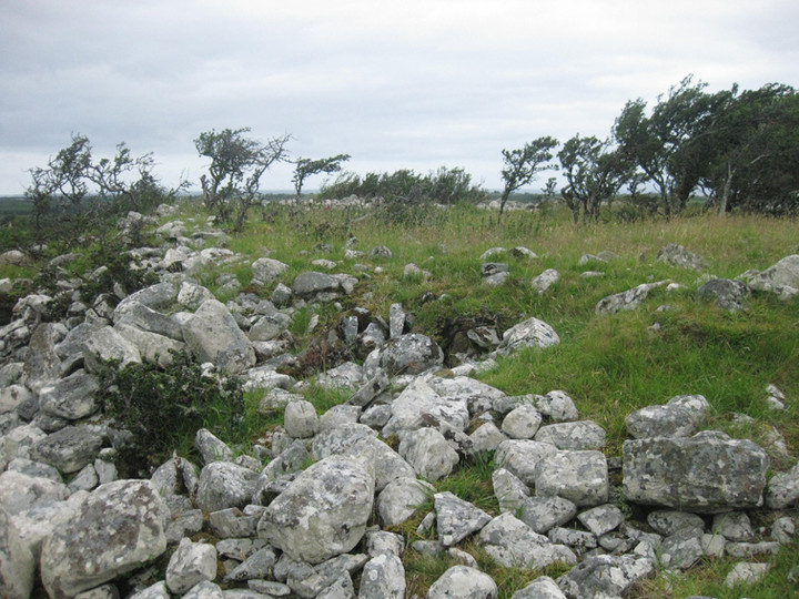

Looking over the cashel/rath up to vertiginous Benwiskin (514m)

At the base of a belltower, in a modern churchyard in Ballaghnatrillick (Béal Átha an Trí Liag). If it were a cube, it would be approx a metre cubed, if you know what I mean. The bullaun is centrally placed, 15cms diameter and I don’t know how deep as it was filled with rubble, seemingly deliberately.


The ‘cashel’ is among the clump of bushes. The mighty Benwiskin dominates the skyline in the distance
Marked as a cashel and bullaun stone on archaeology.ie, I could find very little here due to the summer vegetation. Was this occupied by the people who smelted their iron in the court of the tomb up the road? We’ll probably never know. :-)


Not many angles left. Over the court, towards the tomb entrance, with iron smelter to the right

Streedagh wedge. The stones on the outer ring nearest the point of view are modern placements, left presumably by revellers enjoying the superb location.
What an amazing place! Promonotory forts are places I’d usually bypass, and I hadn’t planned on going this direction until I was recommended both here, and Cloghcor portal tomb where I’d been earlier, by Martin and Joyce Enright.
Inside the fortifications in a mild gale I couldn’t help but wonder at the competition and violence that forced the inhabitants to build this godforsaken fort to make their last stand.
The smallish fort itself is protected to its east by the 57 metre high hill of Knocklane. There is a narrow strip on its north side that allows easy access to the fort. South of the hill would be inaccessible to invaders except by sea and the peak of the hill itself must have been used as a lookout post.
The first (or second last) line of defence is a double ditch, split nearly in half by a causeway. The inner, deeper ditch, is about 4 metres from bottom to top. Either side of the fort are cliffs, though as with the hill, the south would have been much harder to penetrate, hence the building of a bank/wall on the north side.
Between here and the last line of defence there are many signs of habitation structures. And then come the mounds of the final last stand. After here there’s nothing save a few metres of ground and then death.
A site that really caught my imagination.

Looking towards the secondary, inner, ramparts over what looked like the foundations of a shelter/house


On land owned by Leo Leyden, a farmer more interested in archaeology than farming (according to his friend Martin Enright), this, though ruined, is well worth visiting. The massive portal stones, both over 2 metres high, remain upright, with the rest of the stones collapsed onto the chamber.

Cloghcor portal tomb, with the ever-present Knocknarea across Drumcliff Bay

I couldn’t get close to this due to livestock in the field but there seems to be quite a bit of the structure left. According to Survey of the Megalithic Tombs of Ireland, Vol V, County Sligo, it’s a “… small example of the central-court type.”


Not the best time of the year to visit this tomb; maybe for the completist only anyway.
Heapstown is not as roadside a cairn as I had expected from previous reading. It’s close to the road but you’ll need to enter the field with the Sligo Heritage signpost and approach the cairn from there.
Heapstown brought to mind the 3 other cairns of similar size that I’ve visited: Ballymacgibbon, Knocknarea (Maeve’s Cairn) and Cairn D on Carnbane west in Loughcrew. Most every mention of Heapstown includes the probability of it being a passage grave, but given the Cairn D experience, and the fact that the stolen material mentioned by Gladman has so far revealed no signs of a passage entrance, I’d say the possibility is way less than 50 50.
This is a massive construction though. The kerbstones on south-east side are impressive, bulky and robust and a major job to erect in themselves. The pile of the cairn must contain the field-clearance of 100 acres or more.
I’d love to see this monument opened up a bit, some of the vegetation cut back, revealing it in all its grandeur.
Right by the side of the N4 Dublin to Sligo road, about 5 kms southeast of Carrick-on-Shannon.
A small crannog, approx 10 metres in diameter and about double that distance from the shore.


Inner, medieval ring, to the right, outer, prehistoric ring to the left.

Cleaned up, slightly sterile, yet still exceptional – Rathgall bluebells on the last day of May, 2011

Part of the outer ring (maybe an eighth) showing quite well in its tidied up state, 31/5/11


Model in Phoenix Park visitors’ centre. Small, secondary burial showing.


Just the right height to sit on and quaff a few beers. (See previous shot)


Left to right: Seahan with cairn (possible passage grave) and passage graves, Sefingan with cairn (possible passage grave) and Seefin with passage grave.
Taken from the Kiltalown to Brittas road.


