


Not much to see up here either. This mound can only be barely seen as a slight difference in the grass. I believe that archaeology.ie has this referenced as a stone circle for some reason. There is no sign of any stone in the area.
There is a pretty large Rath that is circled on the map just next to it.

Running from right to left where the bush is half ways up the photo, you can make out the line of where the mound begins
Doesnt seem to be much of a cairn left here. Basically all there is the cross. I guess suggests that it may have been a place of assembly in the area. The views from up here are great. It is a commanding spot.
Tricky enough to find as there seems to be a labyrinth of roads in these parts.

You can see evidence of some of the hill-fort ring that circles the tomb. I didnt walk all of it because of the cows but i would think this goes around half of the way around the tomb. It seesm to stop at a boundary wall where the other half of the circle should continue but doesnt.

This “cairn” is just off the N8 at Johnstown on the main Dublin-Cork road. Recently Ive been passing this way quite a bit and wondered about the funny looking trees on top of the hill (They are pretty distinctive from the road).
I checked the OS map and it looked to me as the trees corresponded to the position of a cairn so I decided to take a look.
Head into Johnstown and turn left and then left again where there is a sign for the Spahill. It should be easy to find from here.
I’m not sure about the cairn itself. It seems to be a tree covered mound. The mound itself isnt very distinctive. However the fact that a wall has been built around it to protect it says to me that it is of some importance locally.
It may be possible that the wall around it was built from some of the material from the cairn. I dont know.
There is also a funny feature in the wall. A little “portal” no more than half a metre high. Maybe its for letting wild animals (badgers?) in and out of the enclosure.
I imagined it was left for the little people to get back into their Sidh!
This is an interesting megalithic tomb and hillfort on Spahill in Kilkenny.
The mound itself is maybe up to 1.5-2m high by about 10m diameter. It is made up of stone cairn material and there seems to be two unusual stones sticking out of the top of it. Some of material may have been removed and there is what looks like the remains of a filled in chamber, but its hard to tell.
To the south east, Slievenamon can be easily picked out and there is a great panaroma view all around the site here.
Archaeology.ie has this down as a “passage tomb”. Im not sure if it does have a passage but it would be interesting to find out.

The mound has these two unusual stones sticking up. They are only about 300mm high. “The cows are far away!”

You can see where some of the fill has been removed. It looks to me like possibly some of the chamber has been revealed

The cairn of the tomb looking east.
There is a mound marked here just off what will become the slip road from the M8 into Cahir.
Not a lot to see really. Just said Id post to save anyone the stop.
There is a great view from the mound to Knockgraffon Motte so I think this mound may be from the same period.
There are two fabulous reconstructed crannogs here at Craggaunowen. I hoped they would be a further distance into the lake but are actually only a few metres from the mainland.
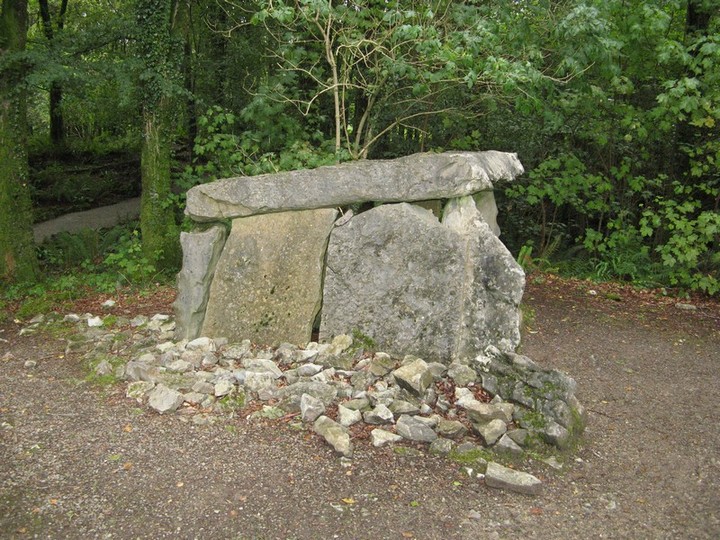
This portal tomb is located in Craggaunowen Folk Park near Sixmilebridge. I believe it is signposted from Shannon / Bunratty.
This portal tomb is so neat looking that at first I thought it was a fake. Seemingly it is genuine.
It is about 1.25m high and the cap stone is triangular making for a strange shaped chamber.
This standing stone is located in Craggaunowen folk park in Co. Clare.
It is about 1.5m high. It is mentioned on the information leaflet that they give out but is not on the OS Map.




From on top of this rock you can clearly see the standing stone of Longstone.
themodernantiquarian.com/site/7744/longstone.html
The Rock itself is a massive natural landmark and this combined with its views of the surrounding hills and the fact there is a church dedicated to St. Bridget beside make me think that it may have had some importance dating back to pre-christain times.

From on top of the rock you can clearly see Longstone in Tipperary.

The church beside the rock is dedicated to St. Bridget
There are 5 standing stones clearly shown on the OS map to the norht of Lough Gur.
They are two far apart to be called a stone row I thing and may be more of an avenue.
Eogan in the North Munster Project suggests they may be leading towards a ford on the river camoge or may be a territorial marker between two different areas.
The stones arent particulary dramatic all smaller than 0.5m high.
The fourth stone is missing and talking to a local guy he told me there was a deal made over its removal.
The North Munster Project shows a few more stones to the south of this that arent on the OS map and I will try and investigate these also.
I think they may be a route from the ceremonial Lough Gur to the defensive hill-fort at Knockroe.

There is a little rock outcrop at the top of the hill beside this stone and you can clearly see south to Knockfennel and Lough Gur

The most northernly of the stones, its in a very marshy area with the camoge river only a few hundred metres away

The next stone at the base of the hill

The most southernly of the 5 stones, its up at a height and you can clearly see Knockroe to the North

This is the middle of the 5 stones shown on the OS map
A lovely stone row and its just in off the road so access is easy.
The tallest stone (beside the tree) is maybe 1m high while the stone at the western end is a lovely craggy rock.
I had this on my list to visit for a long time because I thought Cnoc Firinne may be visible from here.
However the row seems more to be leaning towards the mountains to the south, the Ballyhouras I think.


Looking south towards these mountains (Ballyhouras I think, remind me to go look it up)

This site is close to Friarstown hill. However there is no sign of a stone here. There is a blackthorn thicket in the spot where the stone should be but it clearly isnt in the thicket.

One of five ringforts on friars hill. This is one is a good example.
This standing stone is about 1.5m high by about 1.5m wide. It may be white-washed though I wasnt sure. It it can actually be seen from the road although it is about 1km in from where I parked. There is a spot on the road where it is only about 300m in but parking is very dangerous here.
The standing stone itself is on a hill with about five ring-forts marked on the map. Two I could clearly see on the day. I read in a book by a guy called Tom O’Connor that this was the capital of Munster at one stage and called Teamhair Luachra.
I dont know how trustworthy the reference is though.

The friary that this hill is named after, seemingly its original name was Teamhair Luachra


Looking south from the standing stone

Friarstown standing stone, its about 1.5m high by about the same width, you can see one of the ringforts in the background

This standing stone is no longer here.
It would have stood about 2km to the south of Cnoc Greine.
I spoke to a local man who said that it was toppled because people thought it could have fallen on people or animals! It was then broken up and removed.
It seems to have happened within living memory. I should have asked some more questions of him at the time.
This cairn is at 726m and on the peak of Monavullagh mountain. The cairn itself has been artifically modified into a shelter for climbers and to be honest with the weather that we had on the day it was a welcome relief.
Again there is evidence of a kist in the bottom of it. The cairn itself must be about 7m in diameter.
Interestingly enough it is rock outcrop that can be viewed from ground level.

This rock outcrop appears to be what can be seen from the ground, the cairn itself is much smaller.

