


The North Tipp Inventory places this beside St. Kierans well. However it is actually 500m down the road at what locals call the “knee” of the road. This bullaun is where St. Kieran is meant to have knelt down leaving his knee print.
The bowl itself is pretty small, about 200mm diameter by maybe 150mm deep.
This one is located in a Protestant Church / Graveyard just off the Nenagh to Cloughjordan road.
It is made in a earth fast outcrop. It is about 400mm diameter by 300mm deep.
This bullaun stone is located just off the main cahir to clonmel road beside a fairly easily spotted ringfort across from a nursing home.
I jumped the fence and headed in to have a look, watch the bard-wire fence it is actually electric.
The stone is large and the bullaun must be about 600mm diameter maybe 300mm deep.
There are at least three other half bullauns where it appears the rock was split in half.
From here the hill of Slievenamon really dominates the area.
These two bullaun stones are in the RC church in the village of Lorrha beside a Dominician Friary.
It looks to me as if they may have been transported from elsewhere.
The one on the left is about 300mm diam by 200mm deep. The one on the right is bigger and may be two bowls that has merged into one.
Diameter 600mm by 250mm deep.


This is a possible multiple stone bullaun, it appears as if three bowls have been broken away
This bullaun was moved from Modreeny Churchyard just outside Cloughjordan but it is now used as the holy water font for the RC church in Cloughjordan village, OS Grid Ref R976879.


Church yard that the two bullauns are in, you can see them at each gable.


This bullaun stone is only about a mile from where I live and yet I never heard of it growing up.
The bowls dims in the North Tipp Inventory are diameter 370mm and depth about 300mm. It is about 20m away from a ringfort.
To find it I would recommend a GPS or if stuck give me a shout!

“Darby’s Bed, Galbally
Darby’s Bed is located, like most Irish passage tombs on a hilltop site. Duntryleague Hill is the westerly extension of Slievenamuck hill.
This great Megalith is thought to be the grave of Olill Olum, one of the early Kings of Munster. The name Duntryleague is derived from Dún-Trí-Liag, meaning the fort of three pillar stones. Diarmuid and Gráinne are also said to have rested here in their flight from the angry Fionn Mac Cumhaill”
Taken from aherlow.com/html/heritage_sites.html
This website mentions footprints of Goll as below.
answers.com/topic/petrosomatoglyph
“At Slievenamon (The Mountain of the Women) at South Tipperary in Ireland is the rock that bears the footprints of Goll – ‘the One-Eyed’ – who made a giant leap across the valley to catch up with the hunt of the Fianna”
When I read the information board and it mentioned a spiral votive I was very excited. Especially with the amount of great rock-art that Cianmacliam and Fourwinds are photographing around Ireland.
Im not sure when this spiral is dated to but I presume it it Christain. However it is not a design that is used very often in Christain art.
It looked to me as if the lintels may have been “megalithic” when I did a search when I got home that evening I was happy to see that I had the same theory as Anthony Weir on his website.
He also mentions possible alignments with the Galtys which I have to be honest I didnt see. This is a lovely site and a place where you could bring anyone (non-megalithic) for a quick stop and I think they would be impressed. So I think I will drop in here at another stage.

Close up on the votive spiral

Votive Spiral on the slab where St. Molaga is meant to be buried.

Anthony Weirs take on Labbamologga

Entrance to the church with possible re-used standing stones in lintel.

“Four-poster” with cows for perspective.
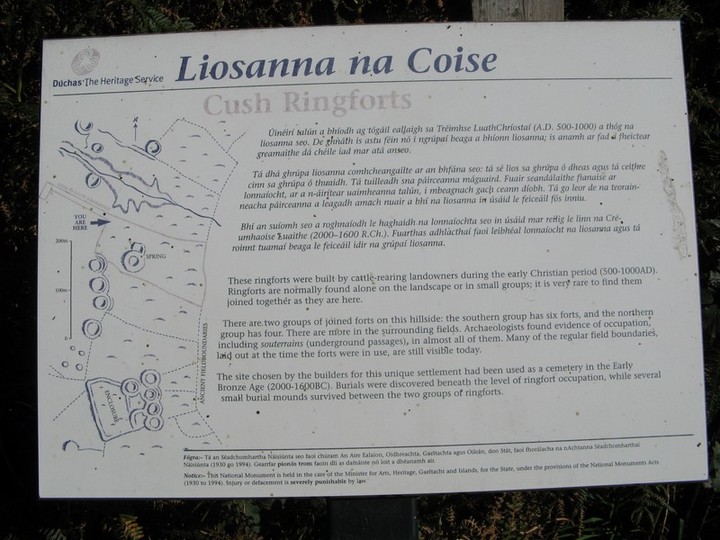
There are three mounds marked as “Tumuli” and a host of ring-forts marked on the OS map.
There are also signs for the Cush Prehistoric Complex from the town of Kilfinnane.
There is a nice parking area for access. However access is not as straight forward as it sounds.
The parking area allows you to visit one of the ring-forts and that is about it. The “Tumuli” are on private property and require jumping over a number of fences and thru a few fields.
I also got the impression thru a number of signs restricting access that perhaps the landowners arent too happy about people being on there lands.
I could be wrong maybe they are just making sure they not liable.
The mounds themselves arent as impressive as I thought they might be, 2 of them are just about 1.5m high while the third is very low and hard to make out.
There is an impressive ringfort very close to the mounds but it doesnt photograph very well.
I believe that burials were found in the bottom of some of the ring-forts and this is really a multi-period site. The mounds date to the Bronze Age according to the info board, approx 2000-1600BC.

The vague outline of the third mound with the first mound in the background.

2nd mound about 1.5m high, you can see the 1st mound to its left.

On my way back from the Rath I had another good snoop around for the standing stone. Especially since it is mentioned on the fairly recent looking information board at the Rath.
Still no sign so I decided to stop in at the farm nearby where I could hear so activity going on.
As I drove in there on my left beside the swing was the standing stone.
I talked to the farmer and he said he had moved it to his yard for safety.
It is a fine standing stone about 2m-2.3m.
I spotted a standing stone on the OS map near a short-cut Ive been taking on the road home from dublin. It is near the town of Ballyraggert in Kilkenny. On a whim I decided to have a look because it seemed so close to the road.
I hopped into the field where I thought it would be hoping to get a quick picture and be on my way again.
The field beside where it should be is the location of a piggery and the sounds or the smell out of it werent great but thats how we get bacon I guess.
I had a good look around for the standing stone marked but there was no sign of it. I decided to have a quick look at the church marked on the OS map.
To my surprise out of nowhere was this massive Rath.
How something like this isnt marked on the map or more well know is beyond me. However it does have an information board and is a national monument with sign and all.
The info board says that the inner diameter is 50m and the the ground inside the ring is 3m above the surrounding field. Parts of the ditch are up to 6m deep.
There is also a souterrain located within it but I didnt see this at the time. It may be closed in.


I decided to head up here finally to to see if this monument is aligned to the Equinox sunrise (as predicted by Fourwinds).
It was a fabulous morning and myself and my Dad sat around on the crisp 22nd of September morn waiting for the sun to rise.
When it finally did, we made a few interesting observations. The first was that the sun does enter the right hand side of the chamber (looking in) lighting it up pretty well. However due to the number of gaps now in the exterior of the tomb any effect is really lost.
We decided it may be worth coming up here next equinox with some black plastic bags to try and darken it as much as possible.
The second interesting thing was the way the sun shone thru the back chamber. I was inside the main chamber snapping away when my Dad spotted it.
Im not sure it this the second chamber was open to the east originally but it looks like a pretty good fit for the equinox sunrise. It may be just a coincidence but if say the east end of the chamber was open but the rest closed off it would surely light the small chamber completely on the Equinox?
The stone itself seems to be lintel like. themodernantiquarian.com/site/1034/baurnadomeeny.html
Perhaps the main chamber is aligned to a different sunrise, I would be interested to know which way the sun rises on say Winter Solistice, is it further north or south than at the equinox?
Following a post on the forum, it seems like the summer solstice sunrise may have the best chance of entering the chamber.
Update
I headed up here on the 22nd of December and thankfully the sun was shining at sunrise. Amazingly enough there were 3 more people up here, so that made a welcome change. The sun seems to shine into the rear portico at right angles to the length of the tomb.
Two of the people that were there had been up there the previous Summer Solstice morning and confirmed that the sun does shine into the main chamber on this day over the foothill of the Mahurslieve. So that is definitely a time for further research.

The light does hit the back stone, but only just

Light entering the chamber looking from the outside in

Light entering the main chamber, taken from within the chamber


Sun shining thru the portico at the rear of the tomb 22-Sept-2007 Autumn Equinox
This holy well is fantastic. When I first got there I was acutally a bit spooked by the area. The trees really enclose it and it is pretty dark beside the well.
It took a bit of time to get used to the unsettling feeling that the place gives off but once I did I relaxed and you really get a very tramquil feeling of the place.
It still seems to be in use today with lots of offering there and the water seems fresh.
As Fourwinds mentions the eddys in the well are lovely and Im sure they were one of the reasons for locating here and for the wells “sacredness”.
There is now also a timber path going from the Kyle to the well so it would be very hard to miss it now.
There can be cows/ cattle and horses in the fields so keep an eye out.
To get a view of the well at a different time of view see Fourwinds site here megalithomania.com/show/site/1239/Kilberrihert.htm


