
Sun rising over Circle C on winter solstice 22nd Dec 2008.
Not suggesting it is really aligned, but it does rise between these two stones from the centre.
Image credit: Bawn79 © 2009

Sun rising over Circle C on winter solstice 22nd Dec 2008.
Not suggesting it is really aligned, but it does rise between these two stones from the centre.
Journal of the Waterford and South East of Ireland Archaeological Society Volume III 1897
Available to download at https://www.waterfordcountylibr[...]ejournals/jwseias/jwseiasvol3/
Pg 92 – Earliest Monuments in Cashel and Emly
by Rev R H Long, Rector, Templemore
“The remains at New Grange, near Drogheda, are considered to be tombs, and the similar mounds in the diocese of Cashel and Emly may be also. The most notable of these are two in Rathcool parish-one at Ardmayle, and one at Knockgraffon. There is no doubt that these mounds are hollow, and there is but little doubt that some day they will be destroyed. One of them had in recent years a narrow escape from a passing railway. I have been informed on good authority that some fifty years age certain workmen, while tilling the field about this latter, came on a subter-ranean passage in which they found what they described as two old swords and an old bucket, which, of course, they treated as rubbish.”
This mound is located in a lovely little village just outside of Cashel.
It is an interesting place, there are the remains of two castles, a church dedicated to St John the Baptist and a very defensive looking Motte to the north of this site all in the vicinity.
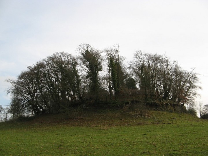
When I travelled to Ardmayle after reading the Waterford Arch journal (which mentions there is a possible passage tomb at Ardmayle) I assumed it was the motte marked to the north that would be the burial mound. So I passed this mound thinking that it looks very interesting.
However after seeing the motte it was pretty obvious that it wasnt a reused mound. So I went back to investigate the first mound I had seen.
The mound itself seemed to be much tampered with, a wall has been built into with a stone arch feature at one side (north-east?).
It is classified as a burial mound according to archaeology.ie.



I was very excited when I found this paragraph.
It hints that the motte may be a passage tomb as I had suspected.
Journal of the Waterford and South East of Ireland Archaeological Society Volume III 1897
Available to download at waterfordcountylibrary.ie/en/localstudies/ejournals/jwseias/jwseiasvol3/
Pg 92 – Earliest Monuments in Cashel and Emly
by Rev R H Long, Rector, Templemore
“What a pity it is that a society is not formed now, e’er it is too late, to make a thorough photographic examination of those that remain, and deposit in our museum whatever articles may be found in them of historic value.
The fairies of our times are growing too merciful to mankind to be trusted any longer with those relics, and when they allow Paddy to get hold of them he does not care anything about them unless they are either gold or silver. However, it is probable that but few of these earth-works are sepulchral; those with a central mound are, I suppose, the only ones that may be.
The remains at New Grange, near Drogheda, are considered to be tombs, and the similar mounds in the diocese of Cashel and Emly may be also. The most notable of these are two in Rathcool parish-one at Ardmayle, and one at Knockgraffon. There is no doubt that these mounds are hollow, and there is but little doubt that some day they will be destroyed. One of them had in recent years a narrow escape from a passing railway. I have been informed on good authority that some fifty years age certain workmen, while tilling the field about this latter, came on a subter-ranean passage in which they found what they described as two old swords and an old bucket, which, of course, they treated as rubbish.”
I was surprised that this bullaun still existed. It is in the third field in from the road. This field is very boggy/marshy and even during a spell of dry weather was still very wet.
The bullaun is lower than the level of the rushes in the field so I would say in summer when they are probably higher it would be even harder to find. It is situated (when looking north) in the middle and left quadrant of the field.
To the north of the stone is an unusual looking double mound with a stream running through it (It may be natural Im not sure).
The bullaun itself has two cups, one that holds water and the other doesnt / broken.

To get the sense of its location within the field.


The sun shining on the back stone of the chamber.
One of the stones of the chamber has collasped inwards and this affects the way the sun shines on the back-stone. There used be a block of timber holding this stone in position but has been removed in the last two years by vandals.

The scene on the 20th literally seconds before a bank of cloud came in. You can see the sun shining into the rear of the chamber.

The sun set on Dec 20th, moments before the clouds came in.
If you read the link about the site, it is a very interesting multi phase site. The cairn being bronze age, the hill-fort Iron Age and being reused as a site for votice offering in the late Iron Age.
Its a pleasant walk although Im not sure about access. There doesnt seem to be any public paths or access. I walked up the hill from the north side of the hill near where a holy-well is marked on the map. This follows the natural contours of the hill. There were a few horses on the hill so keep so be aware of this.
The remains of the cairn on top of the hill are very low with most of it removed. However what is left looks almost like what you would imagine the plan of the cairn to be.
The ditch around the cairn is a later Iron Age enclosure. The hill-fort enclosure is much larger.
The link mentions that this may have been an area of dispute between two fiefdoms in early christain times and that ogham inscriptions on the churches at Clara and Gowran attest to this.


The cairn on top Freestone Hill looking to the north
Link to info on Freestone Hill

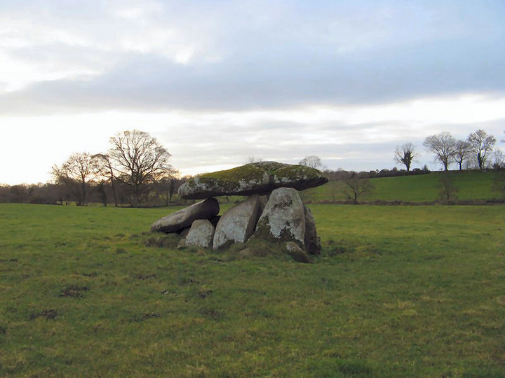


The general area where the tomb is, the type of foliage near it may be of help in locating it.


This is a fairly unique stone as far as I know, it contains both ogham and runic writing.
Although it is a bit recent in terms of megalithic interest I still think it is a very interesting stone.
Seemingly it was discovered in 1916 within the grounds of Killaloe Catheral.
The inscription in Scandanavian runic reads “Thorgrimr carved this cross” and in Ogham “A blessing on Thorgrimr”.
It is now located with in the Protestant Catheral in the town along with a few other great Medieval artifacts.
A high cross, a romanesque door way and a beautiful holy water font.
Im not sure of the opening times of the Catherdal but I would think the best time to find it open is on sundays before and after service which is on at 11.30am.
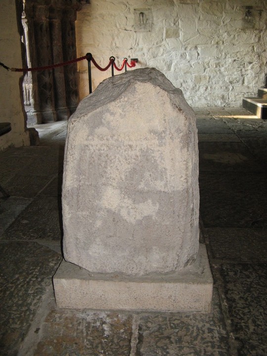
The rear of the stone, seems to show the figure of a man, maybe its thogrim himself.

You can clearly see the runes but it seems that the ogham is pretty worn at this stage.


This stone circle is meant to right beside the road.
I couldnt see anything with the furze etc.
Just did a search of the web and megalithic.co.uk has it as a destroyed stone circle.
Mentioning that a farmer in the area told the contributor this.
All that I could find (same as megalithic.co.uk) was a large stone lying horizontally.
Was passing this way on a cold day on the way to Glantane East. It looked like an easy one to photo as it is right beside the road.
Didnt spend much time on it as I presumed it had been put on the net before.
Not much to say about it really, I noticed only 3 stones remaining in a semi-circular pattern.
None of them above 300mm high.
Nice views to the south, the north was obscured by a rising hill behind it.

Described in the North Cork Inventory as below
Cupmarked stone: In S side of ringfort. Flat slab embedded in ground with 3 cupmarks (diam. c. 0.05m) on surface. Four additional shall depression may be natural. May be same as stone (H 6ft; Girth 3ft) recorded by Broker (1937, 32) in recumbent position, 6 feet out from fort.
Tried to find this stone, found the ringfort it was meant to be in but a combination of a low sun with poor visibility and the ringfort being used to store cattle meant I couldnt find it.
Said Id post just to at least say that the ring-fort is still there, however the stone doesnt jump out at you.
The North Cork Archaeological Inventory gives the following description.
Cupmarked standing stone: Not shown on 1842 and 1904 OS maps. In level pasture, overlooking Blackwater valley to W. Stone (H 1.63m: 1.48m x 0.87m) is subrectangular in plan, long axis N-S. About 15 cupmarks on W face (average diam. 0.07mm)
The standing stone is just to the rear of a farm-building. Best to mark in the village of Knocknagree (Cnoc na Graí) (Hill of the Sun?) and walk down. It can be spotted over the ditch after an old lane just past the farm-house.
Cup-marks aren’t that deep really and if I hadn’t read they were there would not have noticed them as being such.

The stone with some of the cupmarks highlighted


A dark and brooding Knockfeerina from Duntryleague
This holy well and bullaun stone is located just south of Loughrea and can be accessed from the side of the road.
It is dedicated to St. Dympna and its waters can be used to help with nervous disorders etc.
The bullaun stone is about 400mm long by about 200mm high. The cup itself is maybe 200mm in diameter.