Simon Howe looking east (grouse butt is on right of cairn)
Image credit: Tim Clark
Simon Howe looking east (grouse butt is on right of cairn)


Stone row and Simon Howe from ruined cairn, looking west

The stone row with the ruined cairn just visible on the (nearer) horizon on right as a darker line. Viewed from Simon Howe, looking NE


The nearby destroyed cairn, only visible as a faintly raised circular platform – remaining kerbstone (& trig point) on right of pic. Looking SE

The nearby ruined cairn, only visible as a slight cirular ridge the other side of the remaining kerbstone. Looking east

The possible stone circle spotted by moggymiaow. Looks pretty good to me, though I reckon the whole site could be a ruined cairn cemetery. Still, stone circle, cairn circle – I’ll take either thanks!

The ‘moggymiaow’ concentric circles. I’m not quite convinced by the outer one

The pretty definite standing stone spotted by moggymiaow


Another possible?
The far side of a possible circle is pretty clear in this pic when you know that my rucksack (left) and just round from it, my sweatshirt and waterbottle are standing on other stones! And if you look carefully you can see a stone-stump in the near foreground, which would be part of ‘this side’ of the circle. (Slightly left, nearly lost in the heather.) Or maybe I’m just bonkers.

Another view
Ignoring the outlying(?!) stone in the foreground, and taking into account that my rucksack in the distance is standing on a stone....

This part of Howl Moor is just littered with stones, many of which appear significantly to have been set on edge or on end

Another 2 of the numerous stones that certainly seem to have been ‘set‘
Access slightly uncomfortable walk for a few yards north along the verge of the busy A169 before a right turn onto a metalled farm lane. A very short distance along this lane, the hill of Blakey Topping comes into view.
Continuing towards the hill and stone circle, the walk remains on metalled surface for the majority of the distance, with a couple of full width gates which I’m pretty sure were unlocked. Unfortunately, approaching the farm at the bottom of the hill the path leaves the metalled lane and makes a quick descent into pasture.
This descent would be very awkward for anyone with any walking difficulties, but it may well be worth asking at the farm.
Either way, the other side of the farm the walk continues on a small and reasonably steep grassy path up the side of a field next to forestry, to the ‘foot’ of the mound that is Blakey Topping itself.
From here you will probably be able to make out the stones of the circle, a short walk to the right along the top edge of this field.
Sunday 24 August 2003
The hill
Well, as I thought the first time I visited, I defy anyone who’s seen Silbury Hill not to immediately think of it when they first glimpse Blakey Topping from this direction. Big difference, of course is that it’s not man-made. But it’s nearly as weird and pretty much as striking and impressive!
It’s all the more impressive as you draw closer and descend into the valley at its foot, where a farm lies.
The sun was blazing and (it’s off-topic, but I just have to mention it) there were some absolutely beautiful horses grazing in the field that the path crosses by the farm. (Including a reasonably young foal.) I’m not usually all that much of a horse-fan, but the proportions of these beasts and the level of grooming were just spectacular.
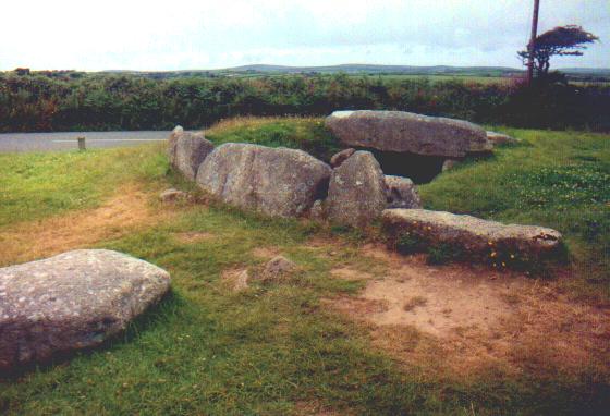
The stone circle
The little stone circle on the slight ridge just below Blakey Topping and above the farm has a lovely feel to it. Incredibly peaceful – being so far from any roads. With the sheep happily munching their lunch, we decided to do likewise, and I can’t remember ever having a picnic in as pleasant a place.
We thought the circle might once have been bigger, but a couple of the remaining few stones didn’t seem as if they were in their original positions, judging from angles of the stones and their positions in relation to each other.
Just speculation and guesswork, but it looked to me like there might have once been as many as 8 or 10 stones forming a circle about the size of the Twelve Apostles of Ilkley Moor. But I could be way off!
Bloody hell! I just checked and Burl says 51ft. The 12 Apostles is 52ft….
Access can be seen from road. Park just outside church gate, which from memory, is average size, weight etc. Easy walk – a few yard across churchyard.
Sunday 24 August 2003
The biggest (tallest?) monolith in Britain wears a stupid hat. But I guess I’d rather the look of the stone is spoilt by a lead cover than by ruinous erosion!
Well, that aside, it’s pretty spectacular! Like one of the Devil’s Arrows after a run-in with a steak-tenderiser, the Rudston monolith is wafer-thin but slightly taller and maybe wider than the DAs. And peeping from under the lead tip, there are signs that it has weathered in a similar way.
Took me a while to decide, but I think it’d be marginally more impressive if the bloody christians hadn’t dumped their god’s gaff right next to it…!!!
Access right next to road. No walk etc.
Saturday 23 August 2003
Very odd. Approaching from the north, the first 2 stones I saw were ones with the holes in. As I’d thought when I noticed them on TMA the night before, they looked about as prehistoric as my 2 year old boy!!!
The tooling is much too noticeable, too angular and just, well, too for anything pre-iron age, surely?
They and a couple of the others did though, put me in mind of Long Tom on Fyfield Down near Avebury, which Julian refers to in the big papery TMA as an iron age waymarker.
And at least one other looks like it could be the real thing!
All that said, surely there’s no doubt what their function is nowadays? They’ve got to be waymarkers for the road when snowed under! (And so, in my opinion, whatever their age they’re unlikely to be in their original positions.)
No idea what the holes are for.
Access a fairly long and ‘fairly’ strenuous walk on a generally decentish path. No stiles gates etc. Moor could be boggy pretty easily.
Saturday 23 August 2003
Near Goathland, you can park safely on the edge of the road at around SE825108. The very edge of the moor here is a veritable network of paths, but within about 20 yards they start to define themselves better.
The one heading to the Two Howes starts off straight up onto the moor, past a ‘garden-type’ bench overlooking the edge of the moor, but you need an OS map really. Landranger’ll do fine though.
The path bears right towards a small tarn, and then left up further onto the moor. Soon you can see the mounds of the Two Howes, with their modern ‘piles of stones’-type cairns on top.
Really nice examples of (almost) complete cairns, though rather eroded – not least by people walking up onto the tops ‘for a look’….
Simon Howe and the ‘trig’ point next to the neighbouring ruined cairn are clearly visible to the south. Goathland looks very attractive some distance away, nestling in the valley more or less north of the Two Howes. The site also overlooks Howl Moor.
Access a fairly long and ‘reasonably’ strenuous walk on a generally decentish path, but with stiles, streams and gullies to cross, as well as the North Yorks Steam Railway track…. Moor could be boggy pretty easily too.
Saturday 23 August 2003
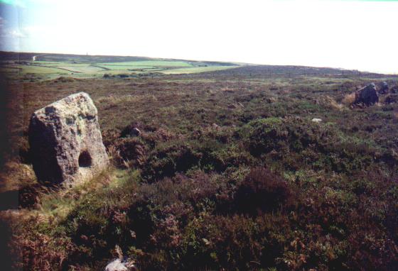
This is my kind of place. A picturesque and longish walk from the nearest road, the cairn(s) of Simon Howe were always likely to be popular with me! And when you get there, a beautifully ruined cairn, another (rather underwhelming) cairn, and to add definite icing to the cake, a 4 stone row….
Heading North on the A169, past the Hole of Horcum look out for a sharpish lefthand bend in a valley, crossing Eller Beck Bridge.
Luckily I spotted it early and was able to pull into a wide grassy lane on the left at SE857982. It’s not very driveable(!) but there’s plenty of room for parking before it narrows to a track and then to paths.
I walked up the lane for a very short distance and went straight on along a narrower but clear path as the lane bent left. This path soon bears right into a little valley, crossing a tiny muddy bit of low land with a stile. There may even be a stream at time.
Just past this point is the North Yorks Moors Steam Railway track. Keep an eye and ear open – you just might be lucky enough (or unlucky enough) to see a train pass. I did – and rather nice it was too.
I simply kept faith and followed this obvious path for a couple of miles across the moor until it reached the cairn. If you use the Landranger map, note that you do NOT have to leave this path to reach Simon Howe.
I really am developing a bit of a fetish for cairn kerbs, kerb-cairns and cairn circles! This ruined cairn certainly has what remains of a beautiful kerb!
Decent sized stones eased back from the perpendicular, leaning outwards at the top. A bit crown or crown of thorns-like – in this respect reminding me very slightly of my beloved Bryn Cader Faner.
Just to the NNW are the remains of a low flattened cairn with one stone stood at its edge. Looks like a remaining kerbstone to me. And between the cairns lies the 4 stone row!!! Two stones are fallen and one of the stones that remains standing is at a crazy angle.
And what a commanding position! To the north it is reasonably easy to make out the silhouettes of the Two Howes and to the west is Howl Moor.
For me Simon Howe has it all – the ‘journey’ the ‘monument’ and the setting. I loved it. (Didn’t even mind the grouse butt!)
Access a bit of a walk involving a climb some would certainly find strenuous. Starts on a metalled lane and continues on pretty good paths, but going can be a little rough. No stiles gates etc but the bit where you crest the crags onto the moor could be difficult for some people. Moor could be boggy pretty easily.
Saturday 23 August 2003
Heading west from Goathland, a modern standing stone marks the left turn to Hunt House. I parked at the point where a small lane ‘dog-leg’s back to the right, downhill towards the remains of the R*man road. This is also the point where the road proclaims itself private.
The lane leads down to Hunt House farm itself, then crossing a stream it bears right, uphill. Just as the track starts to level out to head for Wheeldale Lodge there is a fairly visible left fork that heads obliquely up the hill through the bracken and past some of the lower outcrops.
As it reaches the crags, there is a path to the left up onto the moor. Once onto the moor, from this path the plethora of fascinating stones are to the left, but they’ll be pretty obvious from just about anywhere on Howl Moor itself! There are loads of ‘em.
The bit that moggymiaow singled out on this website is certainly the clearest ‘something’ that I could see. And it certainly includes the most distinctly ‘standing’ stone.
Not absolutely sure it’s a stone circle though myself. Don’t get me wrong – it could be, though as 2 concentric circles I’m even less sure! What it is though is absolutely and definitely something!!!!
One of the reasons I’m a little sceptical about the circle is the sheer number of stones on the moor that look as if they’ve been ‘set’ by man (on edge, or on end) rather than just being erratics or outcrops or quarry spoil or whatever.
I didn’t count em but I reckon there must have been at least 20 – all scattered over this part of the moor – far too many for chance to have left standing on edge or on end.
And several of these ‘set’ stones can be traced into circular patterns with other stones, and there are often vague hints of slight embankment. And though I know a lot of stone circles are embanked, this could be a real ‘giveaway’ considering the proliferation of cairns in the area. (Both Simon Howe and Two Howes can be seen on the horizon.)
So I reckon it’s the remnants of a decent sized and very cool cairn cemetery. But what do I know? Go and see what you think! It’s a nice walk if nowt else!


7 September 2003
Looking southish across the valley


How cool is this? Someone had built a tiny model of the circle at the bottom of the path leading to it.... I had to lie flat on my belly in the damp for this shot, but it was worth it. I love it! (Not as good as the real thing though!)