4 April 2006 Info board with diagrams of construction & what the structure is thought to have looked like when complete
Image credit: Tim Clark
4 April 2006 Info board with diagrams of construction & what the structure is thought to have looked like when complete


Access: Small carpark close to monument. Short uphill walk of maybe 100 metres on edge of field, with worn path across ploughed soil (when we were there) to monument.
Langdysse ved Ristinge Nor is in the south of Langeland, but very easy to reach from Hesselbjerg. From there, go into Hesselbjerg village and turn right. Very soon take the next left, and then the next right.
The road bends left to go north and then left again to go west. Stay on this road and the monument is in a field on your right on the (near) horizon after around 0.5km. There is a small parking place also on the right (north) of the road.
Visited 5 April 2006
Nice one! Covering mound gone, but looking spectacular in the yellow light of the sinking sun.
This strongly reminded me of Lindeskov Langdysse 6 – the one featured on page 157 of Julian’s The Megalithic European, both because of the lack of mound covering and the multiple chambers.
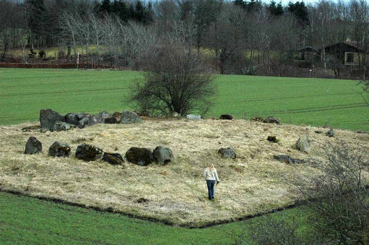
The plan of the monument on the information board at the carpark shows that 2 of the 4 chambers in the langdysse were jættestuen – passage graves. And the ‘middle’ 2 were ‘dysse’ or dolmens – burial chambers without a passage – suggesting that they are older.
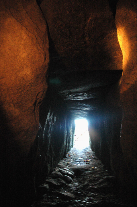
Quite handily, one of each remains reasonably well-preserved (though I think the passage on the passage grave only has one stone from its passage).


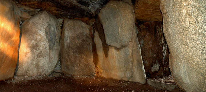
7 April 2006 Looking roughly south – stones of dyssekammer (chamber without passage) in foreground, jættestue (passage grave) in background

7 April 2006 Plan of monument from information board
A detailed page about the site in Danish – nice photos. Information on lots of other monuments in north Jutland if you try investigating the rest of the website
A detailed page about the site in Danish – nice photos. Information on lots of other monuments in north Jutland if you try investigating the rest of the website
Great site for northern Jutland – info on many fairly obscure sites as well as better known ones. As it happens, I know it’s not exhaustive, but it’s pretty good! In Danish but has useful maps etc.

Access: Good – carpark right next to monuments.
Head for Aabenraa on the E45, down near the isle of Als. Leave the E45 at junction 70 to go west on the 24 for a short distance. Then take the 429 west into Rødekro, but almost immediately turning left (south) onto Hærvejen. This road will take you to Hjordkær.
As you reach the town, you will see an industrial estate on your right before reaching the 443. Turn west into the industrial estate and the carpark and monuments are on your left after 100-200 metres.
Visited 3 April 2006
Hmmm. Prehistoric sites throughout Europe include many gritty ‘urban’ survivors that remain powerful, impressive and attractive despite their surroundings.
This ain’t one of them, but it’s still partially a credit to the local archaeological authorities that it’s still here & with what looked like a very good info board. (It was in Danish, so I can’t guarantee it was good!)
Its unsatisfactory setting (and possibly state of destruction) are a familiar story for those of us who care about sites in the UK. The site was excavated in 1980 as several burial mounds were being ploughed up as the land was under industrial development. How many burial mounds there were and what condition they and this site were in, I don’t know.
At least the nearest factory makes something worthwhile – parts for wind turbines....
In English.
Covers the whole of Denmark. Site pages usually have a little basic info and include links to interactive maps (not as good as the inline maps on this site though!) Search takes a little getting used to but is pretty good once you get the hang of it – which took me quite a while!
Link is to the search page, as the navigation to it is pretty cumbersome and I couldn’t find any other way to reach the information than using search!
Access: Area to park right next to Kongehøjen ved Voldstedlund. We didn’t have time to go up to or into Ormhøj or Jordhøj. It looks like a walk of a few hundred metres back along the road would be the best approach, but you may be able to reach them from Rishøj.
Visited 4 April 2006
Aaargh!!! Through the big lens, Ormhøj and Jordhøj look like real beauties, but we were out of time having spent quite a while at Kongehøjen ved Voldstedlund and Rishøj.
To be honest, I hadn’t realised they were so close to Kongehøjen ved Voldstedlund until we were heading away. How I missed spotting them from Rishøj, I don’t know, but it was probably too late by then!
So if you’re lucky enough to visit, the only information I’ve found is that Ormhøj has an oval chamber 5 meters long with a rare smaller chamber behind it. Excavated in the 1890s, finds of earthenware post and flint knives are in the Danish National Museum (Copenhagen).
It looks as though you can get into the chambers.

5 April 2006 Looking east across chambers

5 April 2006 Best preserved of central chambers – looking northish

5 April 2006 Langdysse looking roughly ESE

Wish we’d had this pdf map of the Norreskov monuments – Frydendal Kro, Frydendal Øst, Havrekobbel, Gamle Troldhøj and Baronens høj, as well as many others we didn’t find.
Right-click & chose ‘save as’ skovognatur.dk/NR/rdonlyres/C696C301-64AA-405C-A447-895DA377B5D2/0/30_NoerreskovenAls_kort.pdf
Wish we’d had this pdf map of the Norreskov monuments – Frydendal Kro, Frydendal Øst, Havrekobbel, Gamle Troldhøj and Baronens høj, as well as many others we didn’t find.
Right-click & chose ‘save as’ skovognatur.dk/NR/rdonlyres/C696C301-64AA-405C-A447-895DA377B5D2/0/30_NoerreskovenAls_kort.pdf
Wish we’d had this pdf map of the Norreskov monuments – Frydendal Kro, Frydendal Øst, Havrekobbel, Gamle Troldhøj and Baronens Høj, as well as many others we didn’t find.
Right-click & chose ‘save as’ skovognatur.dk/NR/rdonlyres/C696C301-64AA-405C-A447-895DA377B5D2/0/30_NoerreskovenAls_kort.pdf
Wish we’d had this pdf map of the Norreskov monuments – Frydendal Kro, Frydendal Øst, Havrekobbel, Gamle Troldhøj and Baronens høj, as well as many others we didn’t find.
Right-click & chose ‘save as’ skovognatur.dk/NR/rdonlyres/C696C301-64AA-405C-A447-895DA377B5D2/0/30_NoerreskovenAls_kort.pdf
Wish we’d had this pdf map of the Norreskov monuments – Frydendal Kro, Frydendal Øst, Havrekobbel, Gamle Troldhøj and Baronens høj, as well as many others we didn’t find.
Right-click & chose ‘save as’ skovognatur.dk/NR/rdonlyres/C696C301-64AA-405C-A447-895DA377B5D2/0/30_NoerreskovenAls_kort.pdf
Wish we’d had this pdf map of the Norreskov monuments – Frydendal Kro, Frydendal Øst, Havrekobbel, Gamle Troldhøj and Baronens Høj, as well as many others we didn’t find.
Right-click & chose ‘save as’ skovognatur.dk/NR/rdonlyres/C696C301-64AA-405C-A447-895DA377B5D2/0/30_NoerreskovenAls_kort.pdf

5 April 2006 The langdysse on its ridge, looking northish
Mentioned in passing in The Megalithic European (TME) on page 168.
Access: Walk of just over 1km fairly gently uphill much of the time, along field edges next to the sea. Quite rough underfoot, as much of this is on edges of ploughed fields.
The Langdysse ved Pæregård Strand is on Langeland, and easy to find from Ringlehøj i Snave Skov. Simply continue for around 700m to the end of the same road which ends beside the sea. Walk north along the edge of the fields next to the sea.
7 April 2006
What a shame! OK, so the langdysse’s is quite damaged, but it seems that it could still be well worth seeing if cleared of the thick overgrowth covering it.
It has the remains of 3 chambers and according to James Dyer in 1972 “...is partly surrounded by a kerb of stones.” – Discovering Archaeology in Denmark.
The tough & gnarly vegetation makes it very difficult to investigate the monument properly and to work out what’s what. Even with the plan in Oldtidsminder På Langeland that we picked up at the tourist info office, it’s still too abstract.
And worse, with its seaside setting, it has a wonderful place in the landscape that can only be glimpsed, when it should be striking. The tress and large bushes on it mask the view to th north from the south of the monument – and the view to the south from the north.
All that said, we enjoyed our visit – the coast here is beautiful – but the monument requires a fair amount of imagination and prompted a lot of frustration!

Access: The field was in crop so we simply took a couple of photos and headed onwards. From where we took the photos we couldn’t tell what access was like, unfortunately.
The Jaettestuekammer ved Kinderballe is on Langeland, and easy to find from Hesselbjerg. Simply continue for around 2.5km on the same road out of Hesselbjerg village heading SE then bending south.
When you pass Kinderballe, the road kinks to the west & back to head SSW. The stones are clearly visible a short distance ahead in the field on the right (west).
Seen from a distance 5 April 2006
Huge stones on an imposing mound. The scary bit is how big the covering mound would have been, as as far as we could see, these look like the chambers of a langdysse!!!
I’d love to get up to this place one day!


5 April 2006 From road with a fairly big lens
Visited 2 April 2006
We couldn’t spot this one – is it destroyed? If not, I would have thought it would have been visible from the nearest roads....
We weren’t able to enter the field for a poke around though, so we may have missed something!

2 April 2006 Information board – translations gratefully received!

2 April 2006 Landysser 2 & 3 from the NW

2 April 2006 First sight of Landysser 2 & 3 from the SW

7 April 2006 Plan of monument from information board
Visited 2 April 2006
We don’t have any photos of this, as the only thing we found was a mess and unphotographable under the shadows of the trees. But I’m not sure it was the dyssekammer anyway!

Access: A couple of hundred yards across flat fields, could be boggy in wet weather.
Fenced off but accessible through a typical Danish self-closing gate. These are a normal gate leaning far enough from perpendicular that the gate will ‘fall’ closed when released. (With a ‘stop’ to prevent it falling wide open!) I guess they could be a bit awkward for people with mobility restrictions.
To find the monument, take the 11 north from Varde, taking the turn for Mejls. You will be able to see a few barrow mounds – and you may have seen a few from the 11. They’re pretty common here & by & large, far larger than the ‘standard’ ones we’re used to in the UK.
Don’t go to Mejls itself, but take the first left. Almost immediately, you will pass 2 barrows on your right. Pass a farm on the left and at the far end of the next field, you will find a small parking area/layby on the left, by a building (a bungalow I think).
I’m pretty sure there was a signpost, but basically the monument you’re looking for is immediately beyond the field on your left. You’ll be able to see it & it’s more complete partner from the road. Just walk (roughly west) along the field boundary.
Visited 1 April 2006
It was a misty dank afternoon, but we didn’t care as this was our first Danish monument! We’d driven straight here from the ferry port at Esbjerg, having planned a circuitous route across Jutland to Fyn (or Funen) where we were staying.
James Dyer calls this monument (though there are actually 2) a ‘barrow’. What we found was one complete(ish) barrow mound & a denuded, dug out version* with stones exposed. I’d’ve called it a passage grave, but what do I know?!
(*Or trashed – depending on your perspective!)
Kind of nice combination, actually – a complete barrow (or hoj!) and an exploded version to show how it ‘works’. Nice chamber stones, made up of a slightly tumbled passage & a couple of fairly substantial capstones over a small low chamber.
Not completely thrilling, but well worth a look if you’re in the area or passing en route somewhere! A good start to our danish trip.