
7 April 2006 Approaching the langdysse from the short path to the road
Image credit: Tim Clark
7 April 2006 Approaching the langdysse from the short path to the road


4 April 2006 The top of the chamber showing gap for missing capstone


4 April 2006 Inside the smaller chamber
Glossary (as far as I can glean!)
Dysse: ‘dolmen’ = burial chamber, often with a mound (plural – dysser)
Dyssekammer: ‘dolmen chamber’ = burial chamber – as we usually use dolmen
Runddysse: ‘round dolmen’ = a chambered round barrow (plural – runddysser)
Langdysse: ‘long dolmen’ = a chambered long barrow (plural – langdysser)
Jættestue: ‘giant’s stones’ = passage grave (plural – jættestuen)
Høj: ‘hill’ = barrow
Skibssætning: ‘stone ship’ = megalithic boat-shaped setting
Books & maps
For our trip Jane and I used Julian’s The Megalithic European (see link at top of page to ‘The Books’) and James Dyer’s Discovering Archaeology in Denmark (1972, Shire ISBN 0 85263158 8).
For Langeland, we also used the Danish language Oldtidsmindser På Langeland (1996 Langelands Museum ISBN 87 88509-133) available at the Tourist Information office (and, I would imagine, Langelands Museum itself) in Rudkøbing, Langelands. It doesn’t seem to be available on their website though – langelandsmuseum.dk/museum_en
We also got a useful 1:50,000 map/leaflet in English Six cycling trips on Langeland (ISBN 87-7343-380-2) from the Tourist Information office.
Mapwise, we used the Euromap 1:30,000 of Denmark (ISBN 3-575-03112-6), which allied to some maps printed from the Visit Denmark website (see below) allowed us to find pretty much everywhere we looked for.
I also did some web research with limited success. I have posted the most useful site I found for the whole country (Visit Denmark) in the Links section below. I’ve posted a link specifically for Northern Jutland on the Jutland page. There is also a great PDF document available for some of the sites on Als, see Links on the Als page.
Approximate long/lat coordinates, as I couldn’t see the site among the trees on the aerial photomap. Shouldn’t be too far out though, and there is a signpost and a path through woods.
Access: A short walk fairly gently uphill, about 50 metres at the most from the road.
Very near monuments in the woods near Frellesvig on Langeland. From the 305 heading north, pass Frellesvig and continue to Tranekær. The 305 zigzags through the village, you need a right as the 305 bends reasonably sharply left, right in the middle of the village.
This is Stengadevej and heads south. It may be signposted Ryttermose and/or Stengade, but I don’t think there are any roads you could mistake for it! Follow this for just over 1km and as the road reaches woodland, look out for a left turn (west) to the woods (called Bukkeskovvej).
After about 500 metres, the road turns sharply left (north). Almost immediately there is a jættestue sign and a small layby on the right. A path leads up the hill into the woods to the monument.
7 April 2006
Cool! Despite being quite badly damaged, this one’s a corker!
As you approach, the monument looks pretty underwhelming, but you only see it from the back at first – and yes, it’s pretty ‘second-hand’!
The capstones are missing, as is much of the mound, but both passages and chambers of the double-jættestue are otherwise largely intact. So is most of a fairly impressive kerb on the east (entrance) side of the barrow and the southern end.
This means that as well as being an interesting monument from the point of view of the double passages and chambers, its back view makes it look worse than it is.
It’s actually pretty good-looking from the front! Both passages are short, but the chambers are sizeable – in fact the northern one is huge.
Access: Area to park right next to Kongehøjen ved Voldstedlund. Walk for around 100 metres along the edge of a field the west of Kongehøjen ved Voldstedlund. When we were there, the field was ploughed and the small ‘verge’ at the edge is pretty uneven underfoot.
Visited 4 April 2006
Disappointing when arriving straight from the gem that is Kongehøjen ved Voldstedlund, in many other contexts this would be a pleasing site.
Though dug out around the chamber, the mound is large and enough of the chamber stones are intact to give more than a semblance of what the monument was.

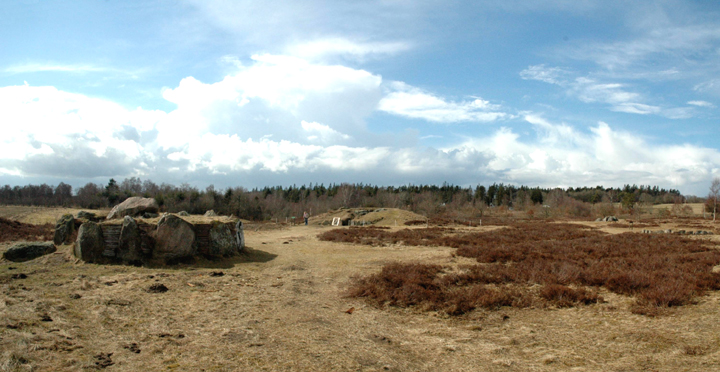
7 April 2006 The langdysse roughly from the south
Featured in The Megalithic European (TME) page 159, under the name Spanskhøj, see below.
Access: Park at farm near monument. Walk of a few hundred metres, at most, across grassy paths between cultivated fields.
Snibhøj and Spanskhøj are not far from the E45, leaving it at junction 34 near Hørbo, which is about halfway between Århus and Aalborg. Head west on the 29 (aka 541). Take the 2nd turning to the left after around 1.5-2km, towards Hannerup & Snæbum. Julian says it’s signposted ‘Rojdrup 2’.
Travel along this road for around 2.5km and then it meets Hannerupvej at an acute angle. Turn right onto Hannerupvej, through the village, taking a right towards Hvilsom onto Hvilsomvej as you approach the west end.
Very soon, the road bends left and you need to park in the yard of the next farm on the left. We were greeted by a friendly woman with a torch and some leaflets (even including some English text!)
Visited 4 April 2006
Firstly, the confusion over the name. The leaflet we were given (or we may have had to pay a little for it, I can’t remember) makes it clear. It says that Snibhøj is the one with access and the one with the denuded tomb next to it.
Perhaps significantly, in his 1972 book Discovering Archaeology in Denmark, James Dyer calls both tombs (and the nearby denuded one) ‘Spanskhøj’.
Whatever it’s called, it’s a fantastic place! A huge mound with 2 separate chambers large enough for us (both 5’ 8”) to stand up in, and each with their own entrance passage alongside each other.
In fact, all 3 tombs (this, Spanskhøj & the trashed one) have the double passage & chambers. We didn’t see any others like them on our trip.
Interestingly, when excavated, Snibhøj’s chambers were completely free of earth because any gaps between chamber stones had been sealed with small stones. The chambers contained about 50 skeletons, of which 18 were 16 or younger.
Dated at around 3,200bc, the condition of the monument – especially the passages & chambers – is wonderful. It’s also quite cool to be able to inspect the denuded tomb, which acts like a groundplan!

7 April 2006 Looking roughly north along the top of the seemingly much reduced langdysse
Access: Area to park right next to the monument and fairly even, flat grassed area around the monument.
Visited 4 April 2006
Amazing! This should be a showcase site – it’s probably the ‘best’ long barrow I’ve ever seen, anywhere. It’s long, high and virtually complete, has 2 chambers with access and a truly spectacular retaining kerb with stones up to 3 metres tall!
One chamber is larger than the other (I can’t remember which!) and is a bit easier to get into, though the squeeze through the passage is fairly tight even for a 5’ 8"er. Once inside though, the chamber is, I think, around 2 metres high (in places at least). Unfortunately, I don’t have photos of this one, as Jane was using the camera.
The passage to the smaller chamber is a real ‘crawler’, as you may be able to see from one of our photographs, but is just as rewarding as the larger one.
The langdysse was ‘partially excavated’ in 1960 and I wonder if it was restored at the same time, as it is so pristine. The tiny amount of information I was able to find online in English was very brief. The only other thing it said was that finds of middle-neolithic pottery and flint knives are in the Danish National Museum (Copenhagen).
A short walk from here to Rishøj which I’m afraid is not in such good condition, but well worth a look.
Access: We weren’t able to actually visit these, as the field was in crop. So we just looked at the one we could see from the road and the field edge, a frustrating 20 metres away. There was no obvious path across the flat (ploughed when we were there) field, so it would probably be best to ask at one of the nearby farm or houses.
Very near other monuments in the woods near Frellesvig on Langeland. From the 305 heading north, pass Frellesvig and turn left (west) after a few hundred yards when the main road bends gently right. (It may be unmetalled, I’m not quite sure.)
Turn left (west) at the next ‘junction’. After just under 0.5km, this road turns right, but the monuments are in the field on the left (south). there is just room to park here.
Seen from a (frustratingly close!) distance 7 April 2006
In a small uncultivated plot in the north end of a field there are a large damaged langdysse and a better (I believe) preserved, but much smaller one.
The northern and larger langdysse certainly looks to have an impressive kerb, but it appeared that its ‘top’ was probably quite disturbed. It certainly looked overgrown when we were there.
James Dyer says in Discovering Archaeology in Denmark that the smaller one has 2 clear chambers with passages to the south-east and large wall slabs filled-in with dry stone. They are both 1.8 metres wide and 3 metres long. He calls the kerb at the SE ‘particularly good’.
We couldn’t see this at all, as our view was blocked by the northern one.

7 April 2006 Long low chamber looking towards north end

7 April 2006 Approaching from road


7 April 2006 The northern langdysse in full from the fieldedge to the NW – the other is hidden behind it


7 April 2006 Exposed chamber stones


7 April 2006 From the 305 road with a biggish lens
Access: We didn’t actually visit this one, just looked at it from the road roughly 100 metres away. There was no obvious path across the flat (ploughed when we were there) field, so it would probably be best to ask at one of the nearby farms or houses.
Around 0.5km north of Dyssekammer i Herslev.
Seen from a distance 7 April 2006
This looked very overgrown, though you could glimpse one of the 2 chambers through the scrubby trees, standing exposed and proud of the mound.
There was no path that we could see and nowhere immediately obvious to park for more than a few seconds, so we decided to give it a miss as we had a lot more to see in our last full day in Denmark.
Must admit, I now kind of regret it, as looking at the one photo I took, it looks as if it may be better preserved than we thought. Visit it & let us know!


Featured in The Megalithic European (TME) page 163, as an inset.
Access: A short walk of about 500m at the most, gently uphill over a grassy track.
Near Horsens & junction 56 of E45. I’ll echo Julian’s instructions, as we got there fine using them! From junction 56 head east on the 52 taking care to stay on the 52 at a strange crossroads where the 52 ‘veers right’ (as Julian puts it). Then he says to go 2.1km along that road, turning right at sign for Rugballe 1.
Follow that lane until you reach a T junction & turn right, the another 0.8km & turn right into trees. Look out for a clearing on the right where the monument is & a clearing on the left where you can park.
It seems from the map that you could actually get there a slightly simpler way by turning off the 52 a little earlier, but there may be something I don’t know about that route!
Visited 4 April 2006
The Great Tomb on Porth Hellick Down in the Isles of Scilly immediately sprang to mind on seeing this, both on TME & in the ‘flesh’. But that’s a good thing, giving 2 of my favourite features in a tomb – a chamber you can get into and a nice set of kerbstones!
Really narrow passage & a comparatively small, low chamber with a beautifully quartz-striped stone as one of its largest orthostats. There is a valley to the north which I think may have offered a pretty cool view, but it’s masked by the trees mentioned in the directions.
Excavators found burials & associated materials in the chamber from the middle and late neolithic. A huge number (7,000!) potshards were found just outside the kerbstones, in front of the passage, and more on top of some of the kerbstones.
Access: Good. You can get within a few yards of the monument by car and enjoy the seaside setting.
For road directions to the area, see Frydendal Kro. Continue NW along the ‘main’ forest road, past Frydendal Øst & Havrekobbel.
It’s about 5km in total from Frydendal Kro. Stay on this road, and keep eyes open for a right-turn to Nygard.
Once you can see the sea, you can also see the runddysse!
Visited 3 April 2006
Wow! A wonderfully pretty monument in a beautiful setting – the sea always makes a fantastic life-filled backdrop!
An impressively complete kerb remains on this picturesque runddysse, which is built on an ‘extra’ mound to allow it to sit level on the slope down towards the sea.
The centrally placed chamber is exposed, but the mound is complete enough to still mean that the sidestones are largely below the surface. It’s topped off with a heavy & shapely capstone .
The sun even came out, highlighting the amazing variety of differently coloured kerbstones and turning them into dollymixtures!
A favourite!


5 April 2006 Eastern jættestue – passage grave, looking roughly east – see passage stone on right


Co-ordinates are for carpark on east side of road, barrows are clearly visible on west of road
Access: Carpark at east of road and short walk along grassy paths to the nearest barrow. May get boggy in the wet and I haven’t seen the path between the 2 barrows – I guess they’re about 200m apart.
For directions, see Mols/Porskær Stenhus. Continue east along this road past Porskær un-named to Agri, continuing ‘straight on’ at the crossroads. The barrows are on the left after about 500m.
Visited 4 April 2006
Having spent hours at Mols/Porskær Stenhus & wanting to get on to Tustrup, we didn’t have time to walk up to these beauties – which I now kind of regret!
However, from the little information I’ve found, it doesn’t look as if there is all that much to see other than the mounds.


4 April 2006 Suspicious stones in SE corner of site
4 April 2006 The complex from the SE – from L-R: Runddysse, Fællesgrav, Dyssekammer & Kulthuset

4 April 2006 The complex from the north – from L-R: Runddysse (top), Kulthuset (below), Fællesgrav & Dyssekammer (far right)


