Not all authorities believe in Hedge’s hornworks, calling the north one only a wall (the south being at most modified natural). Inside the fence the exposed wall [which puts me in mind of the Ness of Brodgar] runs so very straight, smack into the outermost cairn walling. Bronze Age bones were found enclosed in the ‘hornwork’ wall, and the suggestion is that this is therefore itself of that date. How it looks to me is that the wall once led near to the cairn at an earlier time only to be later blocked off by the present outer cairn walling. Outside the fence the possible continuance of the wall presents more the appearance of curving. And to me there look to be a few taller fallen stones on either side of this section – the remains of a processional way ?
wideford
photo of Neolithic art in Sigurd’s article

stone/slab near Duni Geo close to the caiirn – is exposed circular are about it prehistoric or from removal attempt abandoned owing to solidity ?
Image credit: wideford

Christopher Read in front of tomb prior to talk
Image credit: wideford

John (Hedges) wondered if any of the various sites Ronnie Simison had noticed had been taken on board. Well, the 1958 newspaper report on the Tomb of the Eagles reports a little disturbed long grass-covered mound (smaller than Isbister) between the tomb and the burnt mound settlement, with a few protruding stones. The tomb les in front of where two fences meet at an angle, and infield of the start of the straight fence leading to these (near where the 1:25.000 shows another North Taing) this can still be seen. It presents as a low pillow shape of earth with a few stones of varying size, cut through in a few places then ending just before the modern fence. It is most striking that a only a few metres to its south is the angled top of a very regular-shaped stone, projecting a couple of feet or so and about six inches thick. My rough measurements give NGRs for the stone at ND46938423 and the eastern end of the mound at ND46958425 [photos megalithic.co.uk/article.php?sid=20250&mode=&order=0&thold=0]. Is there a relationship with the tomb, as both of these and another ‘hump’ past the tomb can be seen on the horizon from the burnt mound.
The tomb’s north hornwork would appear to continue past the fenced enclosure, and additionally I found a few very small erect slabs barely protruding in the same general area.

N hornwork with ?continuance outwith fence, where (not visible) there are also some dinky upright slabs barely projecting
Image credit: wideford

discoverer [my old boss] John Hedges battles MS today to discuss the excavation
Image credit: wideford
Found during this season’s dig at Green
orkneyjar.com/archaeology/eday2008.htm (the first came from Eday Manse in 1861 and resembles those from Pierowall [1981] and Pickaquoy [1864]).


mound in approach showing excavated southern side with exposure
Image credit: wideford


view looking southerly across mound and ditch, showing hillslope
Image credit: wideford

exposure in northern side of mound, with dark patch left of centre
Image credit: wideford


Seeming curved section in otherwise rectangular feature A
Image credit: wideford

Feature B semi-circular but ?rectilinear
Image credit: wideford

Feature C showing angled dividors
Image credit: wideford

Dividing ‘causeways’ of feature C
Image credit: wideford
Features D (angled) and E (2nd sub-divided feature) with to rear of pic burnt mound
Image credit: wideford

L-shaped feature D
Image credit: wideford
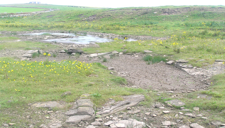
Thought I’d try the Loch of Tankerness again for Raymond Lamb’s double BA house/settlement. The stone in the field by Grieves Cottage is now down. Would have liked to know if anything was thereby revealed but new fences were then being set up in the field. Between the loch banks and the loch itself is a very wide flat margin, and though the water level appears to be now lower this margin has dried out considerably. A not quite row of rectangular features has come to light (or at least become more obvious through ‘drainage’), long ends facing the loch. Coming south from the gothic boathouse the first one [A] is totally dried out and would seem natural with low opposing linear rocky outcrops/walls forming the long ends with big brown slabs covering three sides and a short line of erect stones coming from landward to the northern end of the long east side. There are two stones that look to form a smal circular arc. The next depression [B] is like a cross betwen semi-circle and rectangle, it is filled with grass and there are only a few of the large brown slabs. The third feature [C] is still a pool, has well-formed sides of that low rocky outcrop (the north side is definitely untouched natural with very long rocks as has the lochward side), no large brown slabs. Its south and east sides are fairly unformed. What is most fascinating, however, is the way that the pool is sub-divided narrow-ways by angled ‘causeways’ of mostly small stones. Not all of these visibly go all the way between the long sides. They remind me of the stone rows I had seen around the Harray loch. Why not perpendicular ? My thought was fish traps [?fishponds], though I had no idea why this was sectioned up. The next dried-out pond [D] is distinctly L-shaped and regular. The last feature [E] also still holds water and almost has a complete division. With these last two you can look across at the burnt mound and [groan] ponder connections. At the Waterhall end is a drained arm of the loch, the bottom revealed by nature or artifice, I know not which. So after the time of Raymond’s drought did the loch levels never recover in the time since or could his features now be permanently exposed but unseen ?


circ. mound from S with possible dividing wall of chambers
Image credit: wideford


view from stone scatter above hornworks to circular mound
Image credit: wideford

view across top of circ. mound to chamber/s – is that a division’s top showing as rounded grassy ridge ?
Image credit: wideford


view from chamber B1 of depression B3 left and 2nd ?chamber B2 right
Image credit: wideford


Vehicles aren’t allowed on the Binscarth farm road. After the track to Wasdale, but before you reach Binscarth House, a track goes above the house and along the hill [no, I couldn’t find a way through the gorse, so don’t try]. After a short while you come to ruins on your left, what look like greenhouses in an old quarry, and from there climb up and the pass back above the gorse. First you come to a mound with what look like stone slabs face down into it. Then you come to a small one that looms over a great scallop out of the hillside at the top of which a rocky ?outcrop is exposed. And Howe-Harper comes next in the top right corner of its own field practically. The ditch is quite obvious, though it survives best on the uphiill sides (north esp.) and topside. I’m not certain of the mound standing on a platform myself, looking from the north across at the partially surrounding ditch the word that comes to mind is berm. There are two exposed areas, a good one on the south side with small flat stones set into earth, an a smaller section on the north side only earth but with an area of dark dusty material. From here I went to the bottom right corner where there is a stone style at the wall corner – a design new to me, much larger curved stones like a spiral staircaise – into the next field [which feels like bad cobbling underfoot] for another distant look look at the ‘crannog’. Thinking of tombs overlooking settlements this cairn overlooks a circular ‘thing’ in the valley below, a pow when there’s been heavy rain or a cropmark otherwise.


In the Proceedings of the Orkney Antiquarian Society the chapel site on the east side of the loch is described as evidently used by man because of the rich grass covering it, which sounds more like the north loch site. He too says that there are no signs of the kirk, apart from a few earthfast slabs. Is it possible that Dryden’s plan does not have N at the top in the modern manner. This would certainly explain why he shows a 45’ neck connecting it to the shore but no causeway.
Except Dryden’s sketch is certainly not Wasdale 2

