New website for the campaign group;
moss
To learn more about the 34,000-year-old remains of the Red Lady, our writer spent the night in the cave where his, yes, his bones were discovered in 1823.
It was probably more interesting 34,000 years ago. Then, from Paviland cave you would have seen mammoths, rhinos, oryx, vast herds of deer, even the odd sabre-toothed tiger, all roaming across the plain below. Now it’s just water – the Bristol Channel swashing against the jagged rock beneath the cave, Lundy Island in the distance, the coast of south-west England beyond that.
Paviland is only accessible for a couple of hours a day – unless you fancy a tricky climb – so I’ve decided to stay here for 24 hours, sleeping in the cave, sunbathing on the rocks, and wishing I’d brought some board games to play with my companions, local survival expert Andrew Price and photographer Gareth Phillips.
Cave life can be a little on the dull side.
Paviland cave, on the Gower peninsula in South Wales, is a crucial site for tracing the origins of human life in Britain. It was in here, in 1823, that William Buckland, the first professor of geology at Oxford University, excavated the remains of a body that had been smeared with red ochre (naturally occurring iron oxide) and buried with a selection of periwinkle shells and ivory rods. Buckland initially thought the body was that of a customs officer, killed by smugglers. Then he decided it was a Roman prostitute – he wrongly believed the iron-age fort on the hilltop above the cave was Roman. This misidentification gave the headless skeleton its name – “the Red Lady of Paviland” – and it is still called the Red Lady, even though we now know two things Buckland didn’t: the remains are those of a young man, probably in his late 20s, and they were buried 34,000 years ago. The Red Lady is the oldest anatomically modern human skeleton found in Britain, and Paviland is the site of the oldest ceremonial burial in western Europe.
To get in touch with this epic slice of pre-history I have chosen to sleep in the very spot where the Red Lady was discovered. I’m not sure what I expect to get out of this – a metaphysical connection with one of the first modern humans to come to these islands perhaps; the spiritual uplift pagans who visit this cave get when they come to pay homage to a figure they regard as a shaman. But in reality all I get is bitten on the hand by a spider. If Price had told me before the tide came in that there were spiders and bats in the cave, I probably wouldn’t have stayed.
Price has known the cave (called Goat’s Hole by locals) since he was a boy and is fascinated by the Red Lady. He likes to think spiritual significance was attached to the cave – larger than the others hereabouts, with an evocative, teardrop-shaped mouth – as a burial chamber. “I don’t think the aesthetics would have been lost on people then,” he muses. “And, even if you just look at it in practical terms, sitting up here gives you a great view of your hunting grounds.” Then, with global temperatures colder and sea levels lower, the estuary was miles back from the cave, and the plain teemed with the animals on which the small hunter-gatherer groups depended. They tracked herds of deer across hundreds of miles, and Paviland is likely to have been a stopping-off point on their annual round.
Excavators who came after Buckland found thousands of flints on the floor of the cave, suggesting it was in regular use, even though a few thousand years after the Red Lady was buried temperatures fell further, the ice advanced and Britain was abandoned by early man, leaving the cave’s occupant to lie alone for thousands of years.
As I struggle to get to sleep on the rocky, uneven floor of the cave, I try to dwell on his fate and conjure up the millennia, but all I can register is my tiredness and the constant boom of the sea as it penetrates the hollows in the cliffs.
Price believes the Red Lady was an important man. “Judging by the items that were found, I think he would have played a significant role. The ivory rods clearly had some ritualistic or artistic use. They weren’t hunting tools or anything like that, and that leads me to believe that his role in their society was of either religious significance or as a leader of some sort. I lean towards the idea that he might have been a mystic of some kind, or someone with a spiritual connection.”
What might be called the Welsh romantic view of the Red Lady is given academic backing by a monograph called Paviland Cave and the Red Lady: A Definitive Report, edited by archaeologist Stephen Aldhouse-Green and published in 2000. Aldhouse-Green argues that Paviland had been a “locus consecratus” – a sacred place – for more than 5,000 years. Unfortunately for the definitive report, the skeleton had been wrongly dated to 26,000 years ago, and the case for the symbolic importance of the cave and the possible shamanistic status of its occupant is now thought distinctly sketchy.
Marianne Sommer, in her book Bones and Ochre: The Curious Afterlife of the Red Lady of Paviland, makes the point that Welsh academics may have been seduced into making the Red Lady part of an indigenous cultural narrative. The fact that the Definitive Report opens with a poem called The Wind celebrating the “swift antiquarian/Who teaches me the antiquity of longing” and has a foreword by the then Welsh first minister Rhodri Morgan emphasises the significance accorded to the Red Lady in Wales and helps to explain why the remains have become, as Sommer is not afraid to pun, “bones of contention”.
A few days after my stay in the cave, I go to meet the Red Lady – or at least his bones, in the Oxford University Museum of Natural History. They are too fragile to be put on display, but in the office of museum director, Jim Kennedy, I am allowed to touch them, wearing gloves and terrified of dropping them. The bones, stained red, are laid out in boxes, but you have no sense of the body, which is reckoned to have been 6ft tall, narrow-hipped and gracile – more African than European in body type and typical of a man who had to cover huge distances on foot. The skeleton is missing the skull, the long bones of the right side and vertabrae, all of which were presumed lost, either because of human disturbance or the effects of the sea – the cave suffers occasional inundations.
Kennedy is not a romantic. He dismisses the notion that the Red Lady was a shaman and that the cave was a site for pilgrimage, seeing the burial as “a single event [of] a young man, for all we know a mammoth hunter, who got killed and was buried by his companions”. The rest, he reckons, should be silence, though it won’t be. “If people want to believe this is an important cultural site, they’ll believe it,” he says.
Kennedy’s views may be coloured by the battle he has fought against Welsh pagans and other campaigners who argue that the bones should be at a museum in Wales. Cyt ap Nydden, a druid based in Swansea (though he was originally an engineer from Birmingham called Chris Warwick) and a leading figure in the lobby group Dead to Rights, tells me that the ideal solution would be for them to be returned to the cave, where they could be exhibited under glass. He calls the removal of the bones “grave-robbing”, and says it would never have been permitted at the site of a Christian burial. Ap Nydden has also spent a night at Paviland, which he says was “warm and comforting” and exhibited none of the signs of spiritual disturbance he had expected.
He was clearly not bitten by a spider or bothered by bats.
At Oxford I also talk to Tom Higham, deputy director of the university’s radiocarbon accelerator unit, which redated the Red Lady to 34,000 years ago. “We found that instead of sitting where he had been before, in a cold period, it was actually in a much warmer interstadial [a relatively warm period within the ice age]. We think that’s why people were there. The pattern is emerging of people not really coming to the British isles unless it was warmer. You can imagine it being a peninsula [Britain was joined to the continent at that point] into which people didn’t go unless conditions were right.”
I ask Higham what we can deduce about the Red Lady. “This person probably had some kind of an accident. He’s a healthy person, not very old, doesn’t show any major signs of illness or disease. My guess is there was a hunting party, they were hunting in the environs of the site, there was an accident and the person was buried there.” The cave, in Higham’s view, was not a pagan cathedral but a convenient spot to leave a companion who had met an untimely end, and he says there is no evidence of subsequent pilgrimages, other perhaps than by doting druids and misguided journalists. His prosaic conclusion is unlikely to play well in the more poetic corners of Wales.

Taken from; Neolithic Dewponds and Cattleways – 1905....
Image credit: Arthur & George Hubbard

Neolithic Dewponds & Cattleways 1905..
Title not to be taken too seriously.....
Image credit: Arthur & George Hubbard
Development never quite goes away, its often sneaked in under the door. There is an active FB page ....Save Bremore Heritage Group. NO PORT HERE! following the continuing saga..
Drogheda Port Company has re-submitted a major plan to extend the port’s boundary and develop a €300 million deepwater facility at Bremore in north Dublin.
The semi-state company made an earlier bid to develop the Bremore project, but critically it failed to obtain the approval of the former transport minister Noel Dempsey in 2009.
Any approval given to Drogheda’s plan might be seen to disadvantage Dublin Port, amid questions over whether the capital’s port should be expanded to meet future needs.
Drogheda Port Company is developing Bremore in a joint venture with Castlemarket Holdings, part of the Treasury Holdings Group.
The project would require a Ministerial Order from the next transport minister to sanction the widening of its boundary.
Drogheda Port Company carried out a public consultation in September 2009 on a proposed alteration of its harbour limits to include the area around Bremore.
No planning application has been made in relation to the project, but the joint venture partners are engaged in preplanning preparations.
Both Drogheda Port Company and Dublin Port Company are included on the list of semi-state bodies, including Bord Gáis and the ESB, whose assets and liabilities were the subject of a review by economist Colm McCarthy, with the potential for some of those agencies to be sold.
The previous bid to develop Drogheda Port boundary was complicated by legal concerns that were expressed by the Attorney General, Paul Gallagher.
Gallagher warned the government that it would be ‘’legally problematic’’ to extend Drogheda Port’s boundaries into north Dublin to permit it to develop the Bremore Port plan, given constraints that existed at the time on the powers which the minister possessed to make such a decision.
“However, the Attorney General’s concerns have been surpassed by the enactment of the Harbours (Amendment) Act 2009,which extended ministerial powers to alter a company’s harbour limits.”
Well I never, the word complicit comes to mind!!
thepost.ie/news/drogheda-port-company-revisits-e300m-expansion-at-bremore-54964.html
OLD Sarum will be closed to the public on weekdays for five months every winter under English Heritage cost-cutting plans.
The news comes as another blow to Salisbury’s tourism industry, which already faces the closure of the city’s youth hostel and cuts to the tourist information service.
Five jobs are affected, and consultation is taking place with staff.
The monument will remain open during February half-term, but will otherwise close from Monday to Friday between November 1 and March 31. The car park will also shut.
All but two English Heritage properties where entry fees are charged face similar closures. Stonehenge has escaped, because it is profitable all year round.
PCS union branch chairman Mike Hodgson said indiscriminate government funding cuts are to blame, rather than English Heritage management.
The organisation’s income is being slashed by £40milllion, or 32 per cent, over four years, with the brunt of the cut – £20million – falling in the first year.
The 62 sites affected lose a total of £7million every winter.
But Mr Hodgson said staff cuts will only save £928,000 nationally. Closed sites will have to be maintained and kept secure. They will also have to be opened up for pre-booked educational visits.
“For the sake of another £1million the government could keep the sites open,” he said.
“Most staff are only on £12,500 to £13,000 a year and they will lose five months’ pay.
“Our strategy is to put pressure on the government via local authorities to give English Heritage more money.”
MP John Glen is to raise the issue with English Heritage’s local project director.
He said: “The security of those employed at Old Sarum and the accessibility of the site should be sacrosanct. There are wider implications for Salisbury.”
Wiltshire Council’s Cabinet member for tourism, John Brady, is an English Heritage member. He believes some members will cancel their subscriptions because they are being devalued.
He described the closure as disappointing but said research shows that most people who go to Old Sarum are local and the impact on tourism will be marginal.
“People will still be able to walk round the rings,” he added, “and at least there will still be weekends, and Stonehenge won’t be affected.”
An English Heritage spokesman said: “Only four per cent of all our visitors come during the winter weekdays.
“Most of our 260 free properties, such as Woodhenge, will remain open throughout the winter.
“In light of the reduction in our grant, we believe that this option is the best one.”
salisburyjournal.co.uk/news/journalnewsindex/8955135.Old_Sarum_opening_hours_cut_to_save_cash/
“I think the strangest custom must be that of St Elvis Church where there are the remains of St Teilo’s Well and Church with a pilgrims graveyard. It is said that the sick were brought here and given the holy water then laid to rest in the shade of a cromlech. If they slept all would be well but if they were visited by Caladruis (a ravenish bird of ill omen) their chances were not good. It seems rather like the stories of old people being bedded down in cold hospital corridors in the hope they would develop pneumonia – did that actually happen?”
Taken from; Burials; cenquest.co.uk/Home.htm
Left to die at a cromlech? bit like the Inuit’s old people who were taken out into the snow to die.
St.Elvis never ceases to amaze......
A contentious plan to erect a wind turbine near a historic stone circle in Aberdeenshire will be considered by councillors today.
The proposed development at Newbigging Farm, Chapel of Garioch, near Inverurie, lies just north of the Easter Aquhorthies monument.
The stone circle is thought to be one of the earliest built in Aberdeenshire, and is classed as a scheduled monument, which is a protected site of national importance.
Historic Scotland has objected to the application to build the 150ft wind turbine, which it believes would have a “significant impact” on the setting of the circle.
In a letter to Aberdeenshire Council’s planning department, Historic Scotland’s inspector of ancient monuments Martin Brann states that the monument is “characteristic of the Neolithic and early Bronze Age in Grampian”.
He states that the proposed wind turbine would be about 2,000ft from the stone circle.
“In this location, the turbine will be prominent in key views to and from the monument and we consider that it will have a significant adverse impact on the setting of the scheduled monument.”
The monument consists of 11 stones up to 8ft high with a total diameter of just under 65ft. One large 12ft stone lies horizontally, or recumbent, flanked by two of the upright stones.
Stone circles are believed to have arrived in the Aberdeenshire landscape in about 2000BC, but this particular circle also has a dry stone wall, which is thought to be a more recent addition, in either the 1700s or 1800s.
The applicant, Alan Bruce, of Newbigging Farm, was previously granted permission for a smaller turbine to the north of the property.
The British Airports Authority (BAA) and the Civil Aviation Authority (CAA) were consulted by council officials, but did not object to the plan.
However, representatives of Nats, the National Air Traffic Service, initially objected before withdrawing after a detailed technical and operational assessment was conducted.
Council planners have recommended members of the area committee refuse planning permission on the basis that the turbine would “detract from the quality and character of the landscape.”
Read more: pressandjournal.co.uk/Article.aspx/2179091?UserKey=#ixzz1GhC06bbb
NEOLITHIC men, women and children buried in Orkney’s internationally-famous Tomb of the Eagles suffered serious violence and possibly died of it, according to new research.
Archaeologists studied all 85 skulls from in and around the 5,000-year-old tomb and found that 16 of them have “clear evidence” of trauma.
The skulls – both male and female, children and adults – showed injuries caused by one or more blows to the head inflicted by a weapon.
Some of these severe head wounds healed, leaving people with painful head injuries.
But Orkney-based archaeologist David Lawrence, who led the investigation and revealed his preliminary findings yesterday, said it was very likely that many died of their injuries.
The findings go against the long-held belief that the people who lived in Scotland in the New Stone Age were peaceful farmers and the human race did not turn murderous and become warlike until later in pre-history.
Mr Lawrence undertook the research in a collaborative project between the University of Bradford and Orkney Museum, funded by the Arts and Humanities Research Council.
He said: “By checking if the wounds were healed or not, we can see if someone suffered from severe head trauma just around the time of their death. To say with absolute certainty if they actually died from it is very hard, but some attacks were so severe that the whole skull split in two.
“Other wounds are very subtle and are most easily observed inside the skull, where splinters have been bent inwards.
“Some were caused by a blunt force, like a stone or a mace. Other cases were caused by pointed objects, like a bone-headed arrow and there were also traumas caused by edged objects, like an axe.
“Some wounds did heal. There is a skull of a woman that has three healed wounds which were caused by blows from a blunt object. She also had a dislocated jaw which was badly healed. She must have suffered terribly”
The study’s main finding – that Scotland’s early settlers were not the friendly farmers that historians had thought them – is in line with recent results from studies and finds in Europe.
“For a long time it was thought Neolithic people were friendly farmers, but in recent years it has been proven that this was not necessarily the case,” said Mr Lawrence. “My study shows this again, but this time on an apparently remote island.”
Mr Lawrence is convinced that the people in the Tomb of the Eagles were not ritually killed.
He said: “There was a great variety in the places where people were hit and the instruments used. There is no simple pattern. This variety makes it very unlikely that they were killed in some kind of ritual.
“Some wounds are too directed to be an accident. Some went straight through the skull. Many were very likely caused by a mace, or even just stones, but certainly caused with intent. I think it is very likely that some of the head injuries were suffered during fights face to face. I can’t say if they were fighting each other or different tribes.
“It is hard to tell who these particular people were, and why they were buried in this tomb. There is still a lot of carbon dating to do, but most of the bones seem to date from the fourth millennium BC.”
Background: Farmer’s grim discovery: 16,000 human bones and eagle talons
Isbister Chambered Cairn – better known as the Tomb of the Eagles – sits on the south-eastern tip of South Ronaldsay.
Alongside 16,000 human bones, 70 talons from the white-tailed sea eagle were found within it. It is believed the magnificent birds, once common in Orkney, might have been a totem of the people who built the tomb.
The tomb is 3.5m high and consists of a rectangular main chamber, divided into stalls and side cells. It was discovered in 1958 by farmer Ronnie Simison, while looking for stone to make corner posts for fencing.
After digging for ten minutes he found a dark hole and, using a cigarette lighter, he revealed a chamber containing skulls.
news.scotsman.com/scotland/Tomb-of-the-Eagles-gives.6730778.jp?articlepage=2
Sun Discs;
northstoke.blogspot.com/2008/02/lansdown-barrows-and-golden-disc.html
A few days ago someone who is writing a book on Lansdown race course asked me about the Bronze Age ‘sun disc’ that was found in one of the barrows. It was in fact gold over bronze (most of the gold having disappeared) and was in such a terrible state and in so many fragments that its reconstruction is a matter of drawing the complex pattern on paper, which both Rhiannon and Mike Aston have done.
Having delved through what little information there is, I was struck by the fact that the term ‘sun disc’ might be a misnomer for some of these artefacts. These Irish sun discs are buttonlike almost....
gutenberg.org/files/26880/26880-h/26880-h.htm#Page_62
There is a similar small gold disc found at Jug’s Grave also,
themodernantiquarian.com/site/7660/jugs_grave.html
a few miles from the Lansdown, here we are in Wessex kingdom land of course, where gold is occasionally found in the B/A barrows. So was the 6 inch Lansdown a bigger version of a sun disc, and are the smaller ones more like ornamentation for horses or people, And not to forget the Trundholm Sun-Chariot a gold/bronze depiction of a mare pulling the sun, the disc has a certain similarity to the Lansdown one...
CONSTRUCTION OF the proposed Slane bypass in Co Meath could have implications for the world heritage status of Brú na Bóinne, the site that is home to the megalithic tombs of Newgrange, Knowth and Dowth, a planning hearing was told yesterday.
An international expert on heritage sites said construction of the bypass was likely to result in Unesco “monitoring” the impact on the world heritage site.
Dr Douglas Comer told the An Bord Pleanála hearing that “failure to maintain the outstanding universal value of a world heritage site can threaten its status as such”.
Meath County Council is seeking permission from the board to build the road and the oral hearing is expected to continue until early next month.
Dr Comer, an archaeologist and international expert on culture sites, said there could be “a very large adverse impact” on the site because of the proposed route of the road. He was asked by the council to prepare a heritage impact assessment of the road plan. He said “one might reasonably expect that the bypass will be seen as a further, incremental intrusion on the landscape”.
Dr Comer’s report said that if assurances are given that the bypass will not stimulate new construction in the vicinity of the heritage site and if it is only visible from the top of Knowth, then it would represent a minor change with a moderate/large adverse effect.
However, without such assurances and if the road can be seen from several locations in the Brú na Bóinne site, then it would have a “large/very large adverse impact”, he concluded.
The 3.5km dual carriageway would bypass Slane to the east of the village at a cost of €46 million and divert traffic from the village and Slane bridge where 22 people have died in traffic accidents in recent years.
Archaeologist Finola O’Carroll, who assessed the scheme for the council, said the new road would be visible from Knowth and Newgrange but the long-term impact of this was “in the visual and landscape assessment deemed respectively to be ‘medium and neutral’ and ‘low and neutral’.”
She said that the design of the bridge and the road seeks to minimise the visual disturbance in accordance with the principles of cultural heritage management.
Landscape architect Declan O’Leary said that to reduce the impact of the 200m long bridge, it is designed to sit within the existing topography. It will be 21m above the valley floor and made from a steel/concrete composite. Its crossing is set at a level to reduce the cutting into the valley sides, “limiting the impact on the Boyne valley”, he added.
irishtimes.com/newspaper/ireland/2011/0222/1224290514228.html
A building whose foundations were unearthed during an excavation at Marden Henge near Devizes last summer could have been a Neolithic sauna.
Archaeologist Jim Leary told his audience at Devizes town hall on Saturday that the chalk foundations contained a sunken hearth that would have given out intense heat.
“It brings to mind the sweat lodges found in North America,” he said. “It could have been used as part of a purification ceremony.”
Also found was a midden or rubbish heap with dozens of pig bones, some still attached, likely to be the remains of a huge feast that took place 5,000 years ago.
Mr Leary was supposed to give his talk at the museum, but such was the interest in his subject that it was transferred to the town hall. All 150 tickets were sold and people queued for returns.
Mr Leary said Marden Henge is the biggest henge in England but because it did not have a stone circle associated with it, tended to be overlooked. Before Professor Geoffrey Wainwright examined its northern sector in 1969, it had not been investigated since the early 19th century.
A huge mound, like a smaller version of Silbury Hill, named Hatfield Barrow, once existed there, but it collapsed after a shaft was dug through its centre and was levelled shortly afterwards.
The English Heritage team investigated that area as well as two sites further south, and it was at the area known as the Southern Circle that they made their most exciting discoveries.
It was in the bank of this henge within a henge that they found the chalk floor. Mr Leary described the dig as a work in progress. He said: “We are at a very early stage and there is a lot more to be found. But our fate is in the hands of the government cuts.
“Clearly there is more work to be done, at least another season, but we need funding to do any further investigation.”
thisiswiltshire.co.uk/news/headlines/8845131.The_heat_was_on_at_Marden_Henge/?ref=rss
When Warwick Peirson stumbled on markings on a stone highlighted by snow little did he know it was to spark a passion which would span more than 30 years.
A winter walk with his young son on Ilkley Moor drew his attention to one of the hundreds of carved rocks which have occupied a swathe of West Yorkshire upland for thousands of years.
Efforts to find out more about the curious carvings – which date back to the Bronze Age – led to a quest he is still pursuing more than three decades later.
“I always knew about the stones but about 30 years ago I noticed a stone on Ilkley Moor and the carvings stood out with the snow,” said Mr Peirson, who lives in Menston.
“I went down to the museum in Ilkley to try to try to find out more and I realised there was very little information about them.”
The novice began his own survey mapping out the carved stones and has continued to study the artefacts ever since.
Mr Peirson, 68, said: “I realised that they must be one of the earliest forms of communication of writing, being about 4.000 years old. That fascinated me.
“I have found them addictive. I wrote a letter to the Ilkley Archaeology Group asking for information and wrote, PS, didn’t they think that all the stones should bear a government health warning because they were extremely addictive.”
So when a call was put out for volunteers to help with a survey to investigate the hundreds of carved stones on Rombalds Moor, Mr Peirson leapt at the opportunity.
He is among a group of more than 30 volunteers who are spending three years surveying the stones on the upland that lies between the River Wharfe and the River Aire – collectively known as Rombalds Moor.
Last year Pennine Prospects was awarded a Heritage Lottery Fund grant and South Pennine Leader funding to run the Watershed Landscape Project which covers a range of smaller projects, including Carved Stone Investigation Rombalds Moor.
Gavin Edwards, community archaeologist for the Watershed Landscape Project, said: “The survey on Rombalds Moor will be the most comprehensive undertaken in over two decades, and at the end of the 36 months, with the help of the volunteers, we will have gathered very valuable information.
“Prehistoric carvings are a unique and valuable part of our heritage, providing a direct link with the people who lived here over 5,000 years ago. Although stone is a long lasting medium, it is, nevertheless, subject to erosion by wind and rain and the destructive effects of vegetation.
“It is important to try and capture a detailed record of the carved stones and their surrounding landscape both for current studies and to guide conservation management, so we can protect them for future generations.
Existing records indicate that more than 300 carved panels lie on the moors between the rivers Wharfe and Aire.”
Ilkley Moor has the highest number of carved rocks but they are also to be found at Bingley Moor, Addingham, Baildon and Burley In Wharfedale.
Varying from simple marks to elaborate patterns, the carvings have baffled people for generations and it is still not clear why so many occupy Rombalds Moor.
“They do cluster in different parts of the country but why that should be, we do not yet understand,” said Mr Edwards. “Clearly Rombalds Moor was treated differently to everywhere else. It must have been a special landscape in which these were made but what made it special we just do not know.
“These are marks that were made by the same people who were working that landscape all those thousands of years ago and it is a really tangible connection we have with the past.”
The work is initially focusing on Ilkley Moor where people can learn the craft of recording the stones. Volunteers will record those which are already scheduled monuments, which protects them by law.
Mr Edwards said: “Although they are already known, what we are concerned about is whether they are deteriorating. The survey is to get a detailed record of them as they are today so that we can then see just how much weathering and damage is being caused to them in the future.”
It is hoped that the work will not only record the rate of deterioration but also throw light on what can be done to slow it down – hence preserving the historic stones for generations to come.
The survey will also photograph the carved rocks with a technique called photogrammetry, which creates three-dimensional images that will help researchers in their studies.
A 4000-year-old standing stone in Angus has fallen over due to severe winter weather.
The Carlinwell stone at Airlie, near Kirriemuir, toppled over as the snow, ice and frost from the long cold spell melted away.
The 7ft prehistoric unsculptured standing stone is situated on the crest of a knoll on a farm. Human remains were found underneath the scheduled monument at the end of the 18th century. It is one of a number of standing stones across the country.
Historic Scotland is now looking to carry out an investigative dig of the site, before reinstating the stone.
A spokeswoman said: “Carlinwell standing stone is a scheduled monument near Airlie, Angus.
“The stone fell over a couple of weeks ago when this winter’s heavy frost finally thawed. We were contacted by the landowner and had a meeting with him on Friday.
“Fortunately the stone was not damaged in any way and the owner has cordoned the stone off to protect it from grazing stock.
“Prehistoric standing stones such as this commonly have relatively shallow footings and two thousand years of soil erosion can result in instability. We will be investigating options for reinstating the stone.
“Historic Scotland is hoping to arrange for archaeological excavation around the base of the standing stone followed by its re-instatement.”
news.stv.tv/scotland/tayside/225279-prehistoric-standing-stone-falls-over/
A Guernsey park could be home to artefacts dating back to the Stone Age, according to a Bristol University archaeologist.
Dr George Nash has asked the States for permission to excavate an area of Delancey Park in St Sampson.
Dr Nash has already carried out some test digs in the area and believes a Neolithic gallery grave, with some intact artefacts, is located there.
If permission is given, work should start in June.
Dr Nash will work with the archaeology officer for Guernsey Museums, Phillip de Jersey, on the dig.
Mr de Jersey said: “The stone used to be upright, forming what is called a gallery grave.
“It is quite a rare type of Neolithic monument in the Channel Islands – there’s just this one on Guernsey and a couple on Jersey.
“We got a fair amount of pottery and flint from the trial pits that were dug last summer, and we’ve also got material in the museum’s stores from the excavation that took place here in 1922, so we can be fairly sure there is still material to be found.”
He said any finds would remain in the island and some could go on display in the island’s museum.
This is a place I have never been to, and it looks like no one else has either. Its another Chevaux de Frise, though not the same as the ‘Bryn Cader Faner’ cairn which is so striking.
According to N.P.Figgis (Prehistoric Preseli) the method employed in building these treacherous out pointing stones might have been the result of an itinerant architect, be that as it may Castell Henllys, which is close to Carn Alw, has similar defence methods in its ditch, now covered by a later bank.
Carn Alw though situated at the back of Carn Meini if my map reading skills are right, is defended by “a wide chevaux de frise, incorporating set and naturally grounded stones in roughly three bands” on the easily accessible south-east side.”
Figgis goes on to speculate as to whether the elaborate entrance and boulder lined lane with a kink in its length has something to do with a stock enclosure, either for bulls or ponies, as the area defended is very small. Wild ponies still graze these moors, and they are very like the small ponies depicted on Iron Age coins......
Old traditions, crumbling with time..
I suspect that this news comes in defence of folklore which in turn preserves the archaeological monuments by superstition or ‘piseogs’ to use the rather lovely Irish word.........
Superstitions may seem strange and baseless, but somehow they have clung on for thousands of years. Are they a sign of respect for the past and if so just how much longer might they last?
WHEN I WAS growing up, there was a ring fort at the end of our road. We were warned not to play there. It was accepted that fairy forts contained some mystique or potential for harm. Our parents were probably told the same by their parents, and so on through the generations. But has belief in science and technology replaced faith in superstitions?
Perhaps not. Dara Molloy, a former Roman Catholic priest based on Inis Mór, is in demand to perform Celtic rituals and blessings. When we spoke last week, he was at a wedding ceremony in which he used blessings dating from what he terms “Celtic Christianity”. It involves the tying of knots and sprinkling of water from a nearby well. These practices predate the Roman Catholic Church, he says, and are more in keeping with old Irish customs and beliefs. “We held on to a lot of traditions but they were pushed to the margins of the church,” he says. “People still visit holy wells, climb Croagh Patrick or go to Lough Derg, but many other Irish customs and traditions didn’t carry on and some local priests were instrumental in encouraging them to be abandoned.”
Molloy says when he first moved to the Aran Islands 25 years ago, he was struck by the reverence the locals had for ancient sites and monuments. “Neighbours of mine on Inis Mór who were born and raised on the island had never been up to the hill fort of Dún Aengus,” he says. “One of the reasons given was that their parents wouldn’t let them. They said the place was lived in by the sióga or other world folk. Nowadays some young locals want to have their weddings up there because they believe the energy of the sióga is there. The belief hasn’t been lost. It is just used differently. I have witnessed young adults who want to go to Dún Aengus and sleep there overnight to get the feeling that is up there.”
That feeling may relate to the fact the site has been used by locals for centuries as a place of gathering or safety.
Piseogs [superstitions] are still heeded on the islands too, says Molloy. That is why a red-haired woman who turns up at a door on New Year’s Eve is unlikely to be shown indoors. “It would be a bad omen for the coming years,” he says.
Colm Moloney, managing director of Headland Archaeology, says much has been lost in recent years in relation to Irish folklore. “My own childhood revolved around my dad, who spent a lot of his time walking his greyhounds (and his children) around the landscape of east Cork. Every hill, river, nook and cranny had a story attached to it and he told them so well it was captivating,” he says. “Modern Ireland does not readily facilitate this kind of activity. Landowners have a problem with people wandering across their land and kids have so much to distract them, it is near impossible to get them outside.”
Moloney says much of our folklore is in danger in the hands of the current generation. “The Irish psyche has changed. The respect that was there for the past is losing ground. Our knowledge and links to the past through oral traditions were what made us unique.”
There have been reports recently that a farmer destroyed a ring fort in Co Cork. This would not have occurred a decade ago, he says. Folklore often existed to protect the built heritage and vice versa.
“Every country boy knew the traditions associated with ring forts,” he says. “If you touched the fairy forts something very bad would happen to you. This tradition and similar kinds of piseog resulted in the preservation of archaeological monuments across the country, probably for thousands of years.
“This is a frightening development, where 30 sq m of farmland is of greater value than a monument that may have stood on that spot for 1,200 years.”
EMILY ROSS
irishtimes.com/newspaper/features/2011/0104/1224286698278.html
The question as to whether the burial cairns had been used for ‘walker cairns’, or other purposes remain unanswered. But the following information does state that one of the cairns was excavated in the 19th century. It is also interesting about the extensive settlement pattern below the summit cairns.....
“Carneddau Estate – Moel Faban,
prehistoric houses, paddocks and fields;
The rounded hump of Moel Faban (“moel” in Welsh means bare or bald hill in this context)
dominates the village of Bethesda and on both its east and west sides is extensive evidence of prehistoric settlement.
The east side was surveyed by RCAHM (Wales) for part one of the Caernarfonshire Inventory published in the 1950s but further evidence of prehistoric land use has become more apparent recently, and a new survey as part of a more long-term and comprehensive survey of the hill was commissioned.
The summit has a series of Bronze Age cairns, one of which was excavated in the nineteenth-century from which a collared urn of the middle Bronze Age was removed (now in the British Museum).There is no clear relationship at all but it is thought that some of the dwellings within the field-system could also have Bronze Age origins, but by analogy with similar sites they would normally be thought later. None has been excavated so this earlier date has by no means been confirmed. As well as concrete evidence of cultivation, or at least controlled pasturage, this immediate area has other tantalising evidence of prehistoric life.
This includes Bezant Lowe called the “arrow stone”, a massive boulder on the top of which is extensive evidence of the sharpening of blades. There is to the east of the hill fairly conclusive evidence of burnt mounds situated by the stream of the Ffryddlas where food was cooked by dropping heated stones into small constructed pools, a technique that has been proved to work, as anyone watching “Time Team” will know!”
The ‘Arrow Stone’ on Rockartuk
rockartuk.fotopic.net/c1224904.html
References:
RCAHM(W) 1956 Carnarvonshire vol 1
Bezant Lowe,W. 1927 In the Heart of Northern Wales pp53 – 56
Griffiths,W.E.1959 Arch. Camb 101, pp44
Update on Goff’s news May 2010 – one step nearer to getting a new centre built!
Plans for a visitor centre at a Dorset nature reserve have been submitted.
The borough council has been planning to create a £1m visitor centre at Hengistbury Head for the past 10 years.
People can comment until 3 December on plans to convert the thatched barn at the site to house displays about the area’s archaeology and wildlife.
The council said developers will provide £300,000 while an application for a £420,000 Lottery grant will be made in February.
‘One million visitors‘
The remaining money for the project could come through government funds.
If approved for funding, the new centre would be completed in 2012.
It will feature displays showing the nature reserve’s plants and animals and their habitats.
The centre will also have archaeology exhibitions about Hengistbury Head, chronicling its history from 60 million years ago when it was beneath a tropical sea, through to the Stone Age when humans hunted and camped there, to the Iron Age when it was an important trading port.
Sue Harmon-Smith, chair of the Hengistbury Head Supporter’s Group, added: “Steeped in history and wildlife, Hengistbury Head is one of the most popular and important nature reserves on the South coast with around one million visitors annually.
“It makes sense that we should have a visitor centre and education facility on the site that we can be proud of.”
Public still denied access to Vixen Tor.
Hoards of Bronze Age weapons, pots still full of food and elaborate textiles have all been uncovered at an archaeological dig near Peterborough.
The unusually well-preserved finds are due to a fierce fire in 500BC, which caused the artefacts to sink rapidly into the peaty fen waters.
Archaeologist Tim Malim said: “It’s more impressive than Flag Fen.
“The textile finds are unique within England,” he continued. “We’ve never found anything from this date before.”
The archaeologists also quite literally walked in the steps of our Bronze Age ancestors – uncovering human and animal footprints in the mud.
Wooden Piles.
The dig took place at Must Farm, a quarry owned by Hanson at Whittlesey.
For around 15 years, the company has arranged for archaeologists to excavate sites ahead of its clay extractions.
But this dig almost did not take place.
A local archaeologist swam in the quarry pits as a child. He remembered seeing wooden piles in the water, so suggested Cambridge Archaeological Unit (CAU) should explore the site, which was not in the path of the next Hanson clay extraction.
Mr Malim is the head of archaeology for the environmental firm SLR Consulting. The company works closely with Hanson and CAU.
He explained that the settlement was unusual. Instead of being built on dry land, the buildings were attached to a large wooden platform balanced on thick, oak piles driven into the bed of the River Nene.
This helped preserve the finds when a fire broke out sometime between 700BC and 500BC.
‘Really intense heat‘
“Imagine a fire like the one at the pier in Weston-super-Mare,” Mr Malim said. “The wind acts under the supports to build up a really intense heat and incinerated the pier, and it was like that with this platform.
“As a consequence of that the buildings above, and all that was in them, burnt very quickly and dropped into the water where the fire was rapidly quenched and the contents preserved.”
As well as the textiles, rare pottery, wicker fishing traps, wooden walkways and bronze tools have been revealed.
The archaeologists also discovered glass beads previously unknown to this late Bronze Age, so they could be imports from Europe.
The contents of the 50 pots of food are awaiting analysis by experts.
The site is so significant that Hanson has ensured its preservation by building a bund around it to prevent it drying out.
Rising sea levels gradually flooded this part of Cambridgeshire from the late Bronze Age, causing people to retreat to the higher, drier areas, with wooden walkways linking them above the bogs.
Large-scale clay extraction in this area, known as the Flag Fen basin, has given archaeologists the chance to discover how the landscape developed and uncover the way people lived.
Now the Cambridge Archaeological Unit has moved on to another part of the quarry where two burial mounds, or barrows, cobbled tracks and fishing traps have been uncovered.
news.bbc.co.uk/local/cambridgeshire/hi/people_and_places/history/newsid_9168000/9168497.stm
Note; its probably within a few kilometres of Flag Fen
Prehistoric carvings on Ilkley Moor are to be preserved with help from the latest technology so future generations will be able to enjoy and study them.
Archaeologists hope to create digital 3D models of the carvings amid fears the originals could be eroded away.
Community archaeologist Gavin Edwards said this was an important development.
He said: “We have the opportunity to create three-dimensional models so they can be studied in the future as they exist in the landscape itself.”
Up until now the only way we have been able to represent them is in two dimensions.
It is thought they were made by some of the first hunter-gatherers to reach what is now Ilkley Moor – an area which now has the highest concentration of Mesolithic sites in the world.
Gavin Edwards explained: “What we have is a dense concentration of evidence telling us about how the very first people who moved back into this area were exploiting the landscape and how they were surviving.
“They are part of the story of how human interaction with their surroundings started to change the very appearance of the landscape.”
The Prehistoric Carved Rocks project has been launched by Pennine Prospects, an organisation dedicated to the regeneration of the South Pennines.
The project’s aim is to ensure that even if the original carvings erode away due to the effects of the weather they will still available for study in centuries to come.
Gavin Edwards said it was all down to the latest technology that the project could be launched.
He said: “Up until now the only way we have been able to represent them is in two dimensions.
“But a new technique has become available to us whereby we can photograph them with digital images.
“Then, then there is a very complicated piece of software which can combine the images to produce a three-dimensional model of the actual carvings.”
The ancient carvings can be seen in a number of places on Ilkley Moor
Volunteers are now being urged to come forward to join in the Prehistoric Carved Rocks project in Ilkley.
They will be given the chance to find out more about the project and register their interest.
Training sessions
In the coming months, training sessions covering surveying, recording and photographic techniques will take place.
It it is hoped volunteers will then be able to put all these skills into action on Ilkley Moor over the next three years.
Volunteer Eddie Nash said he thought it was well worth getting involved for a number of reasons.
He explained: “It is an interest I have. I find it fascinating looking back and trying to understand how our ancestors lived and developed and gave us what we have today.
“It is the usual situation where people do not understand and use what they have on their own doorstep.
“Once you start to make them aware of things, they are very surprised about what is to be found.”
news.bbc.co.uk/local/bradford/hi/people_and_places/history/newsid_9167000/9167130.stm
To add to Rockrich’s news........
Experts are hoping to set up a community team to help investigate ancient rock carvings.
The ‘CSI: Rombalds Moor’ project will look at the moor’s stone remains including the Twelve Apostles Stone Circle, the Swastika Stone and the cup-and-ring carvings known to archaeologists worldwide and the many walkers who visit the area each year.
But now the experts want to train a group of volunteers to take part in crucial work in recording vital information about the ancient sites.
The project is managed by rural regeneration enterprise Pennine Prospects. It is part of a wider Watershed Landscape scheme, which won almost £2million of lottery funding earlier this year to restore the landscape of the South Pennines uplands Next month the CSI: Rombalds Moor project will be launched in Ilkley, with workshops by experts and a guided walk to the archaeological sites.
Among the speakers on Saturday, November 6, will be community archaeologist Gavin Edwards who is known to many Ilkley people for his work at the town’s Manor House Museum and Art Gallery, and English Heritage’s head of metric survey Paul Bryan.
A team of consultants has been selected to lead the prehistoric carved-rocks project on the moor. In addition to making written records, it will involve photographing the rocks to create 3D images through the ‘photogrammetry’ process. The workshop will give more local people a chance to learn about the project and register their interest.
A spokesman for Pennine Prospects said: “Over the coming months a series of training sessions covering surveying, recording and photographic techniques will be organised for community volunteers to learn how best they can help undertake the work over the next three years.
“The project will also aim to ensure that the skills and knowledge gained during this time will then allow the work to continue and develop after the project has come to an end.”
The project launch and workshop will take place at Church House, next to All Saints Parish Church, in Church Street. The event will be open for registration and refreshments between 9am and 9.45am.
Anyone interested in taking part is asked to contact Gavin Edwards in advance at [email protected], leave a message at the Manor House Museum, Castle Yard, Ilkley, or telephone (01943) 600066.
thetelegraphandargus.co.uk/news/local/localbrad/8475971.CSI__Rombalds_Moor_project_launched/?ref=rss
Stone Age flour found across Europe
A myth destroyed, they actually ate bread with their meat........
Starch residues on stone tools suggest early humans ate a balanced diet.
Ground grains found at Stone Age sites suggests early modern humans did not subsist on meat alone. Once thought of as near total carnivores, early humans ate ground flour 20,000 years before the dawn of agriculture. Flour residues recovered from 30,000-year-old grinding stones found in Italy, Russia and the Czech Republic point to widespread processing and consumption of plant grain, according to a paper published online this week in Proceedings of the National Academy of Sciences1.
“It’s another nail in the coffin of the idea that hunter–gatherers didn’t use plants for food,” says Ofer Bar-Yosef, an archaeologist at Harvard University in Cambridge, Massachusetts, who was not involved in the study. Work in recent years has also uncovered a handful of Stone Age sites in the Near East with evidence for plant-eating.
The meat-centric view of early modern humans stems partly from the fact that meat-eating leaves a more indelible mark in the archaeological record than omnivory, says Laura Longo, an archaeologist at the University of Siena in Italy and an author on the paper.
Stone blades used for hunting and animal bones bearing cut-marks are common finds, whereas plants leave few relics. Complicating matters, archaeologists typically washed the grinding tools used to process plants, removing any preserved plant matter, says Longo.
Early omnivores;
Beginning in the early 2000s, Longo and her colleagues started analysing unwashed stone tools from a 28,000-year-old human settlement in central Italy called Bilancino. Patterns of wear on the sandstone tools suggest that they were used for grinding, like a mortar and pestle. The stones were also coated with several kinds of microscopic starch grains. Longo and her colleagues identified the grains based on their shape as belonging to the root of a species of cattail and the grains of a grass called Brachypodium.
The researchers also found grinding tools coated with cattail and fern residues at human sites in southern Moravia in the Czech Republic and south of Moscow, all dated to roughly 30,000 years old.
Unlike Neolithic humans, who domesticated and cultivated grains such as wheat and barley, these hunter–gatherers relied on wild vegetation. However, many of the plants found by Longo and her team were widely distributed, offering a reliable, even nutritious source of food, she says. For example, once ground and cooked, the cattail grains contain nearly as much energy as domesticated cereals, the researchers calculate.
Grinding tools bear traces of 30,000-year-old cattail and fern (right).PNASBar-Yosef says that the study proves that flour-making was common to early modern humans. “I’m pretty sure that you’re going to have many more cases where there is evidence for the use of plants by humans.”
Bruce Hardy, a paleoanthropologist at Kenyon College in Gambier, Ohio, expects that flour-making dates back even further than 30,000 years. “This is not isolated to a small group of people. It’s a regular part of subsistence for humans,” he says.
After all, humans, ancient or modern, just aren’t equipped to live on a diet of meat alone. “If you get that much meat in your diet not balanced out with other nutrients, you get protein poisoning,” says Hardy.
WHEN Hamish Mowatt decided to investigate a mysterious mound as he tidied an Orkney garden, he had little idea he would uncover a hoard of bodies that had lain untouched for around 5,000 years.
Archeologists believe the tomb he discovered under a boulder outside a bistro in South Ronaldsay could lead to new insights into how our neolithic ancestors lived and died.
But they face a race against time as water washing in and out of the newly uncovered tomb could wash away its contents and dissolve any pottery and human remains inside.
Mr Mowatt uncovered the tomb in the garden of Skerries bistro and self catering cottages. He said: “There is a big slab of stone about eight foot by eight foot and I had always wondered what was underneath it. I had a bit of time at the end of the summer and I thought I would take a look.”
Mr Mowatt, who runs a boat business, pushed a piece of wire down a hole at the side of the stone and discovered a cavern underneath it. He then pushed down a rod attached to an underwater camera he used for looking at wrecks and discovered a chambered cairn with skulls against the edge.
“I have never really been that interested in archaeology, but when the rod went down into the chamber I could not leave it alone, my blood was pumping when I got a torch. Carole and I looked inside and saw the skull sitting in the murky water.
“It was amazing to think that we were looking at something that had not seen the light of day for 5,000 years. One of the skulls was looking straight at me. It set me back for a moment.”
Mr Mowatt and his fiancee Carole Fletcher, who owns the bistro, got in touch with Julie Gibbon, the Orkney county archeologist, who told them they had made a significant find.
“She was really blown away. She said it might be the missing part of the jigsaw – and they could discover a lot by excavating it.”
Ms Gibbon said she hoped Historic Scotland would support the excavation of the site – which is around 100 metres away from the Tomb of the Eagles, the chambered cairn where Orkney farmer Ronnie Simison found 348 human skulls in 1958.
Mr Simison and his family run a tourist attraction based around the 3,000 year old tomb – which they believe was a centre for sky burials – where dead bodies were exposed on the cliffs so the sea eagles could carry off their meat.
Seventy talons from sea eagles were found inside the tomb as well as 14 birds.
The archeologist said the new find was extremely significant. She said it could lead to new discoveries about the life and the death of some of Orkney’s earliest inhabitants.
Until the tomb is fully excavated it will not be known how extensive it might be.
There are at least four skulls inside – but the archeologist believes there may also be shards of pottery – or other artefacts which can be rescued before the water washes them away.
“Orkney has some of the best preserved archeology in Scotland and a lot of what we have has national and international significance.
“But it is not every day that you find the remains of people buried 4-5000 years ago.
“Because we have found them now we have the chance to excavate them in such a way that we can save more of the DNA within the bones. These sorts of techniques were not available 50 years ago.”
Ms Gibbon said the tomb needed to be examined quickly because of potential damage from water seeping in and out, but that said she had high hopes that the excavation would shed fresh light on neolithic society and ritual.
“I’m hoping Historic Scotland is going to support us. This is going to give us a lot of answers about neolithic life.”
Bistro owner Carole Fletcher said she was thrilled about the discovery. “I am really quite excited. I know there are a lot of archeological sites on Orkney but this is something special. I’m very interested to find out what is under there. It isn’t every day you find something like this.”
heritage.scotsman.com/heritage/Neolithic-tomb-found-in-garden.6561782.jp
A 4000-year-old burial chamber in Perthshire has been described as Scotland’s “Valley of the Kings.”
Excavation of the site at Forteviot, just to the south of Perth, began in earnest last year and ever since it has been regarded as something of an archaeological jewel.
It was uncovered by the Strathearn Environs and Royal Forteviot (SERF) project, run by archaeologists from Glasgow, Aberdeen and Chester universities, and the results of the project’s first three years have just been published by Perth and Kinross Heritage Trust.
Researchers first discovered the four-tonne capstone slab covering the burial chamber in 2008, but had to wait until last year to organise the resources to lift it.
The team hoped there was a burial chamber beneath, but had no idea it would prove to be one of the best preserved sites in Britain and almost undamaged by the passage of time.
The high quality of preservation proved to be “virtually unique” and archaeologists were soon claiming the early Bronze Age grave as a site of “exceptional importance.”
At the entrance, a stone sealed the grave so well that organic materials survived, with a leather bag, unidentified wooden objects and plant matter among the items discovered.
A distinctive bronze dagger with a gold hilt band was also found.
The plant matter was later identified as meadowsweet blossoms and was hailed as the first proof that people in the Bronze Age laid flowers upon the graves of loved ones.
Together with carvings on the underside of the capstone, the findings were also taken as evidence that the grave was that of a significant person.
The team returned this year to reveal more impressive burials and monuments, indicating that the site was a significant centre of ceremony and burial in the early prehistoric and the Pictish periods.
Excavations explored part of a massive Neolithic timber enclosure and demonstrated that the monument required over 200 huge timber posts, which needed a ramp to hoist them into position.
The work has shown that the site continued as a major burial location and ritual landscape into the Bronze Age.
The area has also revealed square barrow cemeteries from the Pictish period and although these burial mounds have not yet been dated, their form suggests they are early, demonstrating that people in the Dark Ages were using the prehistoric earthworks as a sacred place for burial in the period around the formation of the Pictish kingdom.
Perth MSP Roseanna Cunningham said the burial site helped to underline “the absolutely central importance of this part of Perthshire to the whole of Scotland.”
The full story, along with illustrations and photographs, is revealed in a new 60-page Perth and Kinross Heritage Trust publication, Strathearn Environs and Royal Forteviot Project Report 2006-2009.
The booklet is available from the trust’s office, Perth Museum and Art Gallery and the AK Bell Library.
environmental survey for site on outskirts of Stornoway lodged with Scottish Government
Plans to build a controversial £200million windfarm on the outskirts of Stornoway have moved forward.
The developer – a partnership between Amec and French government-owned EDF Energy – wants to erect up to 50 giant turbines adjacent to a busy tourist route.
Now an environmental survey has been lodged with the Scottish Government, which has responsibility for deciding if the windfarm goes ahead due to the large scale of the scheme.
The proposal sparked fierce criticism after it emerged the community-owned Stornoway Trust signed a deal potentially committing crofters’ grazings to the huge development for decades.
Stornoway Trust factor Iain MacIver said: “I am delighted with the recent progress the application has made.
“This application will be respectful and mindful of the impact on the local environment and habitats and this has been foremost in our thoughts as we have submitted the application.
“Our development partners have listened and learned from their previous application and we are committed to engaging and consulting with the local community during this project. I believe the appointment of a community co-ordinator will be integral to this process as we aim to form an ongoing partnership with the local community.”
The environmental report covers all aspects of how the proposed windfarm would be assessed from an environmental perspective during the design, construction and operational phases.
It addresses surveys to include noise, visual impact, archaeology, ecology, tourism and hydrology. Bird studies started on the site last spring.
The current proposal follows the Scottish Government’s refusal to approve a controversial plan for a £700million chain of 181 huge turbines up the length of Lewis. Depending on the number of turbines which receive planning permission, up to £1.5million is being offered annually in community benefit after electricity starts generating in three or four years.
Read more: pressandjournal.co.uk/Article.aspx/1932165?UserKey=#ixzz10QxDcFAx
UK archaeologist finds cave paintings at 100 new African sites
Striking prehistoric rock art created up to 5,000 years ago has been discovered at almost 100 sites in Somaliland on the Gulf of Aden in eastern Africa.
A local team headed by Dr Sada Mire, of the Institute of Archaeology at University College London (UCL), made the finds, which include a man on horseback, painted around 4,000 years ago – one of the earliest known depictions of a mounted hunter.
Leaping antelopes, prancing giraffes and snakes poised to strike are among animals and reptiles depicted with astonishing clarity.
Such is the quality of the paintings that at least 10 sites, scattered across semi-desert terrain, are likely to be given World Heritage status.
Mire, who has just become a UN consultant for Somaliland, said: “These are among the best prehistoric paintings in the world.
“Yet Somaliland is a country whose history is totally hidden. With wars, droughts and piracy in Somalia, hardly anyone has researched the archaeology until now. But it’s absolutely full of extraordinarily well-preserved rock art.”
Dhambalin, about 40 miles from the Red Sea, features horned cattle, sheep and goats painted about 5,000 years ago. The animals have distinctive bands around their backs and bellies, which suggests farming or ritual traditions.
The pictures also depict animals, such as giraffes, no longer found in Somaliland.
Mire, who is Somali-born, has been struck by paintings of “eerie headless creatures”. She said: “Sometimes the cattle are represented as necks or horns, a pictorial shorthand that was evidently sufficient to convey meaning.”
Other paintings are more mysterious, such as the 2,000-year-old colourful images of the full moon, half-moon and geometric signs at Dawa’aleh. Mire believes these depict the ancient artists’ view of the world, time and space.
Somaliland is in the northern part of Somalia, an area slightly larger than England but with a population of just 3.5m. More than half are nomads.
Once part of the Ottoman Empire, it was a British colony from 1884 until 1960. Although it declared itself independent of Somalia in 1991 and has a
separate government, it is yet to be recognised as a separate state.
Mire said: “Whereas Somalia has suffered with an ongoing civil war
and piracy, Somaliland has remained peaceful.
“Yet despite boasting a stable, grass-roots democracy, the country has
not been recognised by the UN and so does not formally exist, leaving
it a breakaway state teetering on the edge of a violent region.
The discovery of the 100 sites follows that of cave paintings at Laas Geel in 2000. For centuries, they were known only to nomads, who believed the site was haunted by evil spirits.
Mire’s research study will be published this month in Current World Archaeology.
guardian.co.uk/world/2010/sep/17/cave-paintings-found-in-somaliland

Long shot showing the echoing line of (is it Carn Ingli?) to the capstone of Pentre Ifan...
Sound recording at reconstruction of Stonehenge in Maryhill Monument, USA........
Did our ancient ancestors build to please the ears as well as the eyes? Trevor Cox pitches into the controversial claims of acoustic archaeologists
“The wind, playing upon the edifice, produced a booming tune, like the note of some gigantic one-stringed harp. No other sound came from it... Overhead something made the black sky blacker, which had the semblance of a vast architrave uniting the pillars horizontally. They entered carefully beneath and between; the surfaces echoed their soft rustle; but they seemed to be still out of doors...”
This atmospheric description of a “temple of the winds” comes from the dramatic climax of Thomas Hardy’s novel Tess of the d’Urbervilles. The setting is Stonehenge, arguably the most famous prehistoric monument of all. Its imposing ring of standing stones is visible for miles on Salisbury plain in southern England. On the day of the summer solstice its outlying “Heelstone” is exactly in line with rays of the rising sun. A more perfect example of the visual impact of an ancient monument would be hard to find.
Might we be missing here something that both Hardy and our prehistoric ancestors understood? Some archaeologists have begun to think so. They argue that sound effects were an important, perhaps even decisive, factor in how early humans chose and built their dwellings and sacred places. Caves that sing, Mayan temples that chirp, burial mounds that hum: they all add up to evidence that the aural, and not just the visual, determined the building codes of the past. But is that sound science?
Assessing the claims of “acoustic archaeology” rapidly encounters a fundamental problem: sound is ephemeral. Pottery fragments, coins, bones and bits of buildings can survive for centuries, waiting to be analysed, interpreted- and reinterpreted. The sounds of the past, by contrast, have long since died away. Where historical records make mention of acoustic intent in designing structures, the claims are often based on faulty science (see “Sound design?“). Going back into prehistory, we do not even have the luxury of knowing what our ancestors were thinking- or often a clear idea of the original layout and acoustic properties of the structures we are interpreting.
There is, however, a plausible argument that sound must have been important to our ancestors, perhaps more so than it is to us now. “Today we guzzle sounds and make a lot of noise,” says UK archaeologist Paul Devereux, an advocate of the claims of acoustic archaeology. “We are visually very sophisticated, but acoustically very primitive.” Our ancestors, by contrast, would have been “acoustically more calm and attentive in a much quieter world”, he says. Without artificial light, listening intently would have been imperative to ward off night-time predators. In a time before writing, moreover, information was principally communicated orally. It seems reasonable that prehistoric humans would have paid more attention to their acoustic landscapes than we do today. “Senses as a whole were more fused,” says Julian Thomas, an archaeologist at the University of Manchester, UK. “There wasn’t the separation of vision from the other senses as there has been over the last few centuries. Nowadays we tend to prioritise vision.”
New Scientist
tinyurl.com/36eddvm
A photo of the ‘Stonehenge’ Maryhill site;
en.wikipedia.org/wiki/File:Maryhill_stonehenge_WWI_monument.jpg

Trellyffant apparently means Toad’s Town, and I had come across a story some time ago that said a chief had been buried at the cromlech who had been eaten by toads.
Well there is a different version of the story and the man eating toads. In this version Giraldus Cambrensis tells of a young man called Cecil Longlegs who “during a severe illness, suffered as violent a persecution from toads, as if the reptiles of the whole province had come to him by agreement; and though destroyed by his nurses and friends, they increased again on all sides in infinite numbers; being wearied out, he was drawn up in a kind of bag into a high tree, stripped of its leaves; nor was he there secure from his venomous enemies, for they crept up the tree in great numbers, and consumed him to the very bones”
Poor old toads no wonder the witches were always boiling them up! taken from
Myths and Legends of Wales; retold by Tony Roberts
Laser scanners are being deployed in Orkney to record details of some of the island’s key historical landmarks.
A team from Glasgow School of Art and Historic Scotland will scan the chambered tomb of Maeshowe, the Ring of Brodgar and Skara Brae settlement.
The two-week project is part of a plan to build up three-dimensional images of 10 World Heritage sites.
Among the sites already scanned are New Lanark’s 18th Century mills and Mount Rushmore in South Dakota.
The Heart of Neolithic Orkney is made up of the tomb of Maeshowe, the Stones of Stenness, the Barnhouse Stone, the Watch Stone, the Ring of Brodgar and Skara Brae.
The recording process will involve a laser being fired millions of times a second at each of the monuments.
The end result will be a precise record of the sites, accurate down to just millimetres.
The data will be used to assess the physical condition of the structures and provide a foundation for future conservation, site management and aid archaeological understanding.
Project leader Dr Lyn Wilson said: “Though we have already scanned New Lanark, the scale and nature of the monuments will be an entirely different challenge.
“This will be the first site in the Scottish Ten project where we have existing scan data: comparing data acquired at different dates will allow us to measure any changes in condition of the monuments.”
Sites including the Antonine Wall, St Kilda, and the Old and New Towns of Edinburgh will also be scanned.
bbc.co.uk/news/uk-scotland-north-east-orkney-shetland-10990965
Images from all the sites will be made available at ......
www.historic-scotland.gov. uk/news
So it says elsewhere but also interestingly in another article it says..
“Results gleaned from the scanning process will be shared with the California based CyArc Foundation, who are pledged to create a storehouse of open access data relating to World Heritage Sites.”
There is at least a dozen press reports on this, from the Guardian to the Daily Mail which got the reconstruction wrong but provides most of the photos, the following from the Yorkshire Post...
“Archaeologists said today they have discovered Britain’s earliest house, in the North Yorkshire countryside.
Teams from Manchester and York universities who are working at Star Carr, near Scarborough, said the Stone Age house dates to 8,500 years BC, when Britain was still connected to mainland Europe.
The team, which also uncovered an 11,000-year-old tree trunk, unearthed the 3.5m circular structure next to a former lake.
The house predates the house previously thought to be Britain’s oldest, at Howick, Northumberland, by at least 500 years.
The team said they are also excavating a large wooden platform made of timbers which have been split and hewn. It is thought to be the earliest evidence of carpentry in Europe.
Dr Chantal Conneller and Barry Taylor from the University of Manchester have been working with Dr Nicky Milner from the University of York at Star Carr since 2004. The house was first excavated by the team two years ago.
According to the archaeologists, the site was inhabited by hunter-gatherers from just after the last Ice Age, for between 200 and 500 years.
They migrated from an area now under the North Sea, hunting animals including deer, wild boar, elk and enormous wild cattle known as auroch.
Although they did not cultivate the land, the inhabitants did burn part of the landscape to encourage animals to eat shoots and they also kept domesticated dogs.
Dr Milner said: “This is a sensational discovery and tells us so much about the people who lived at this time. From this excavation, we gain a vivid picture of how these people lived. For example, it looks like the house may have been rebuilt at various stages. It is also likely there was more than one house and lots of people lived here.
“The platform is made of hewn and split timbers; the earliest evidence of this type of carpentry in Europe. And the artefacts of antler, particularly the antler head-dresses, are intriguing as they suggest ritual activities.”
Dr Conneller said: “This changes our ideas of the lives of the first settlers to move back into Britain after the end of the last Ice Age. We used to think they moved around a lot and left little evidence. Now we know they built large structures and were very attached to particular places in the landscape.”
Mr Taylor added: “The ancient lake is a hugely important archaeological landscape many miles across. To an inexperienced eye, the area looks unremarkable – just a series of little rises in the landscape.
“But using special techniques I have been able to reconstruct the landscape as it was then. The peaty nature of the landscape has enabled the preservation of many treasures including the paddle of a boat, the tips of arrows and red deer skull tops which were worn as masks.
“But the peat is drying out, so it’s a race against time to continue the work before the archaeological finds decay.”
Universities and science minister David Willetts said: “This exciting discovery marries world-class research with the lives of our ancestors. It brings out the similarities and differences between modern life and the ancient past in a fascinating way, and will change our perceptions for ever. I congratulate the research team and look forward to their future discoveries.”
The research has been made possible by a grant from the Natural Environment Research Council, excavation funding from the British Academy, and from English Heritage, which is about to schedule the site as a National Monument. The Vale of Pickering Research Trust has also provided support for the excavation works.
The world-renowned Star Carr site, which dates back to 9,000BC, was first discovered by local man John Moore in 1947 after he came across a flint blade in a field and began digging for artefacts.
He found a number of other significant sites in the area before excavation went ahead between 1949-1951 and 1985-1989. Dr Conneller, Dr Milner and Mr Taylor recommenced excavation in 2004.
yorkshirepost.co.uk/news/Britain39s-earliest-house-is-unearthed.6467344.jp
the Guardian report..
guardian.co.uk/science/2010/aug/10/britains-oldest-home
The Daily Mail.....
ITV news (once past the chocolate advert)
itv.com/yorkshire/stone-age-des-res58472/
Well the new top destination tourist place according to The Telegraph. Skara Brae and The Flintstones for goodness sake!
Scotland’s Orkney Islands provide a rare glimpse of Stone Age life, says Paul Humphreys...
Many archaeological sites are baffling to the layman. How often do you see a few bits of half-buried wall accompanied by a not-very-informative plaque telling you that this might have been the palace of a bishop? Or perhaps it was the outer wall of a stonemason’s workshop…
Neolithic structures such as Stonehenge are awe-inspiring and magical, but they don’t tell us much about everyday life in the Stone Age. To get an idea of how Neolithic people actually lived, you should head for the far north of Scotland, to Orkney, home to some of the most impressive prehistoric settlements in the whole of Europe.
Here you will find remains so well preserved that you don’t need an expert to tell you what’s what. You can see for yourself. The best-known example is Skara Brae, a settlement on Orkney Mainland (the largest island) that was buried for centuries until its cover was blown by a storm in 1850.
What came to light was a 5,000-year-old housing complex that surely inspired the creators of The Flintstones. For here there are beds, hearths, dressers and storage units, all carefully crafted in stone. It’s easy to imagine a Stone Age chap arriving home in the evening after a hard day’s cattle herding, hanging his stone axe up by the front door, sitting around the fireplace and sharing a meal with his family before snuggling up for the night under a pile of warm animal skins.
There are so many extraordinary sites in Orkney that it’s difficult to know where to start – so Visit Scotland has done visitors a great favour by launching an online Archaeological Treasures Trail that covers all the major sites (there are also trails for the Outer Hebrides and Shetland). Here you’ll find suggested itineraries and potted histories of the sites, together with opening dates and times and other useful tips.
Skara Brae, with the Ring of Brodgar stone circle and henge, the Stones of Stenness and Maeshowe, together form a World Heritage Site called The Heart of Neolithic Orkney, and these are the highlights of the Orkney trail.
Places such as these abound in Orkney, with one island alone having 200 known prehistoric sites. Sometimes called the “Egypt of the North”, Rousay is home to Midhowe Broch, probably the finest surviving example of the tower-style fortified homes that were common in Iron Age Scotland. Here again, so much remains of the interior – including dividing walls, a stone tank and the like – that it’s easy to imagine people living there and going about their everyday lives.
Of course, not all the sites of Orkney are so easily understood. Only yards away from Midhowe Broch is the much older Midhowe Cairn, known as the “great ship of the dead”, a vast 30-metre Neolithic chamber. County archaeologist Julie Gibson says that only a few skeletons were found within a monument that seems to have been used for hundreds of years – so it looks as though a few individuals were selected in some way. It’s possible that the bones of ancestors were brought out from time to time and used in rituals – but that is really just an educated guess.
The word “ritual” is a favourite term of tour guide and archaeologist Caz Mamwell, who is candid enough to admit that whenever the experts are baffled by such things as stone circles, “ritual” is a handy explanation. Sometimes, though, the archaeologist’s job is made a good deal easier – as in the case of the Maeshowe Chambered Cairn, back on Orkney Mainland.
This monument was already ancient when the Vikings came across it in the 12th century – and left their mark in the form of runes carved into the stone. The building is mentioned in the Orkneyinga Saga – the History of the Earls of Orkney – a fascinating account of the 300 or so years (from AD 900-1200) when Norsemen ruled the waves in these parts.
Their influence can be felt to this day in the Orkney accent: Scottish, yes, but with a distinctive Scandinavian lilt that sets these islanders apart from their southern countrymen.
But not all historical monuments here date from the distant past, Continues here..
telegraph.co.uk/travel/destinations/europe/uk/7929936/Orkneys-archaeological-treasures.html
From the Telegraph and Argus....
Work is underway to compile the first comprehensive record of ancient monuments on Ilkley Moor.
Archaeologists have started a three-year project to photograph rock carvings across Rombalds Moor and will use state-of-the-art technology to produce 3-D images of the stones.
The results could prevent deterioration of the carvings and create a fuller picture of the history of Ilkley Moor.
The study is part of the South Pennines Watershed Landscape project, which won almost £2m of Lottery funding in April to restore the landscape and heritage of the uplands.
It will examine the impact of man’s intervention on the area, and is being led by community archaeologist Gavin Edwards.
Mr Edwards, who is based at Ilkley’s Manor House Museum, said the study could be the last chance to get a good record.
“The first thing is getting people involved in helping record the carved rocks because although they are well-known, we don’t have a standard record of them all and that’s what we need to establish because we are worried about erosion,” he said.
“We don’t have a benchmark record of how much damage has been done, but hopefully this will help us understand how we can protect them in the future.”
The imaging techniques will include photogrammetry, which uses two-dimensional photographs to create 3-D computer images.
Workshops will be held to teach people how to record data and an education worker has been commissioned to recruit schools to take part.
Mr Edwards said: “We’ve got to stop looking at that landscape as if it’s natural – it looks the way it does as a result of human activity in the past. “I’m certain there’s a huge amount of knowledge out there. I’m hoping we can create a vehicle through a website where people can offer information and get a clearer picture of what’s going on. There’s got to be a permanent legacy from this.”
thetelegraphandargus.co.uk/news/8312600.Study_of_Ilkley_Moor_stones_being_rolled_out/?ref=rss

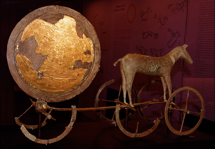

This is the badger hole with its spill of gleaming white chalk, reminding one of the time when the barrow was built.
Maeve Kennedy in the Guardian....
Stone tools, flakes and the remains of a final feast at the site in Wiltshire suggest the huge sarsens that now stand at Stonehenge were brought to Marden Henge........
The last revellers seem to have cleared up scrupulously after the final party at Marden Henge some 4,500 years ago.
They scoured the rectangular building and the smart white chalk platform on top of the earth bank, with its spectacular view towards the river Avon in one direction, and the hills from which the giant sarsen stones were brought to Stonehenge in the other.
All traces of the feast – the pig bones, the ashes and the burnt stones from the barbecue that cooked them, the broken pots and bowls – were swept neatly into a dump to one side. A few precious offerings, including an exquisitely worked flint arrowhead, were carefully laid on the clean chalk. Then they covered the whole surface with a thin layer of clay, stamped it flat, and left. Forever.
In the past fortnight, English Heritage archaeologists have peeled back the thin layer of turf covering the site, which has somehow escaped being ploughed for more than 4,000 years. They were astounded to find the undisturbed original surface just as the prehistoric Britons left it.
“We’re gobsmacked really,” said site director Jim Leary.
Giles Woodhouse, a volunteer digger who must return next week to his day job as a lieutenant colonel in the army bound for Germany and then Afghanistan, has been crouched over the rubbish dump day after day, his black labrador Padma sighing at his side. He has been teasing the soil away from bone, stone and pottery so perfectly preserved it could have been buried last year.
“It gives one a bit of a shiver down the backbone to realise the last man to touch these died 4,500 years ago,” he said. His finds, still emerging from the soil, will rewrite the history of the site.
Marden in Wiltshire has been puzzling archaeologists for centuries. It is set almost exactly half way between two of the most famous and tourist-choked sites in Britain, Stonehenge and Avebury, but it is far larger than either. The ragged oval of outer earth banks at Marden, completed by a bend of the Avon, enclose more than 14 hectares, compared with 11.5 hectares at Avebury, where the banks surround an entire modern village.
Famously – to its comparatively few devotees and visitors, that is – it is the biggest henge in Britain that isn’t there, surrounding one of the biggest artificial hills in Britain, which isn’t there either.
This is the first excavation since Geoffrey Wainwright, former chief archaeologist at English Heritage, explored one small corner of the site in 1969. What stunned the archaeologists when they started work three weeks ago was just how much is left.
Once your eye is in you can see it: the sweep of the ditches, the belt of trees hiding some of the earth bank, which still rise to three metres in some places, the stain in the grass marking the lost barrow and its massive surrounding moat, and the wholly unexpected discovery – the second, smaller henge so close to the modern houses that the roots of two trees at the foot of a back garden are actually growing into its bank.
The neolithic buildings were not where others have looked for them, on the level in the centre of the henges, but on top of the bank.
“We’ve all been looking in the wrong place,” Leary said, “there will have to be a major rethink about other henges. And it’s actually almost terrifying how close to the surface the finds were – there’s also going to have to be a major review of our management plans for other sites.”
The only known image of Hatfield Barrow – an early 18th century map in the archives of the landowner, Corpus Christi College in Oxford – shows the artificial hill as a jaunty little sandcastle sporting a cockade of trees. It once rose to a height of almost 15 metres, half the height of Silbury near Avebury.
The two antiquarians who burrowed like rabbits through scores of Wiltshire earthworks in the early 19th century, Sir Richard Colt Hoare and William Cunnington, punched a massive shaft through Hatfield Barrow in 1807. They scrappily recording finds that torment the modern archaeologists, including animal bones, burned wood, and “two small parcels of burned human bones”.
They left the shaft open, possibly intending to return in another season, and the mound collapsed. This is a phenomenon Leary knows well, having led the rescue excavation before the engineering works to stabilise Silbury, which was also left riddled with slowly collapsing holes by Georgian and later diggers.
The farmer at Marden filled in the moat, which an 18th century naturalist recorded as fed by a natural spring and never dry even in the hottest summer, and sold the collapsed hillock as top soil. Leary’s massive trench has uncovered barely a trace of hill or moat.
If the hill disappointed, the excavations at one of the original entrances and at the small henge certainly do not. They are revealing what appears to be a broad gravelled ceremonial road leading towards the river. Discovering undisturbed neolithic surfaces and building platforms on this scale counts as a discovery of international importance.
There is no evidence of permanent occupation of the dwellings or the site as a whole. As in the work led by Professor Mike Parker Pearson at Durrington Walls, 20 miles away (he couldn’t resist coming over to help dig, and some of his former students had the pleasure of giving him orders) the implication is of people gathering for seasonal rituals and feasting, and maybe a work camp.
“A completely artificial division has been made in the past between domestic and religious, recreation and ritual,” Leary said. “We’re going to have to rethink all that. It’s not one thing or the other, it’s everything mixed in together.”
If it wasn’t a village, or a temple, or a farm, or a cemetery, what was Marden for? Leary suspects the answer may be emerging in stone working tools, and flakes of sarsen, turning up all over the site. If you were going to drag sarsens the size of double decker buses from their original site to Stonehenge, he said, the obvious route is straight through a natural gap in the hilly landscape, which would take them through Marden.
The evidence that Marden was a sort of builder’s yard for the most famous prehistoric monument in the world may have been in the mud under the boots of Leary’s puzzled predecessors.
So why did they leave? Maybe with Stonehenge complete, the sarsens shaped into the giant trilithons which still awe the hordes of modern visitors, their job was done. They tidied up nicely, turned out the lights, and left.
guardian.co.uk/science/2010/jul/28/marden-henge-builders-yard-stonehenge
Archaeologists are carrying out a virtual excavation of Stonehenge to discover what the area looked like when the monument was built.
The multi-million pound Euro study will map the terrain and its buried archaeological remains with pinpoint accuracy, organisers claim.
The millions of measurements will then be analysed and incorporated into gaming technology to produce 2D and 3D images.
The research will take three years.
Equipment will be spread over an area spanning 4km this year and a total of 14km over the next three years.
Project leader Professor Vince Gaffney, from the University on Birmingham, said: “We aim to unlock the mysteries of Stonehenge and show people exactly what the local area looked like during the time the monument was created.
“The results of this work will be a digital chart of the ‘invisible’ Stonehenge landscape, a seamless map linking one of the world’s most famous monuments with the buried archaeology that surrounds it.”
Dr Christopher Gaffney, from the University of Bradford, said: “Rather than looking at typically small discrete areas we intend to cover the whole of the World Heritage Site.
“We will do this using emerging technology that allows us to pull large banks of sensors behind a quad bike and using real time GPS to locate the measurements.”
The study is funded by the Ludwig Boltzmann Institute for Archaeological Prospection and Virtual Archaeology, in Vienna, and the University of Birmingham, and is assisted by the National Trust and English Heritage.
The following is taken from Britarch May/June 2010, its parts of a letter from Lethbridge to the editor of The Times 12/6/36, and he mentions a book written by Bishop Hall in the 18th century.
Its about the giant of course and definitely folklore but he seems to have existed.
Lethbridge also mentions another giant at Oxford.....
All very curious, considering its fairly flat round Cambridge and Oxford not many stones to chuck around.
“A Giant called All Paunch, who was of an incredible Height of Body, not like him whose Picture the Schollers of Cambridge goe to see at Hogmagog Hills, but rather like him that ought the two Aple Teeth which were digged out of a well in Cambridge, that were little less than a man’s head. When I was a boy, about 1724, I remember my father or mother as it happened I went with one or other of them to Cambridge......always used to stop and show me and my brother and sisters the figure of the giant carved on the Turf; concerning whom there were then many traditions, now worn away. What became of the two said teeth I never heard”.
Lethbridge goes on to write that there is an Elizabethan tradition of calling “Knight to Knight come forth” and a giant will come forth and fight you. And it is possible that at this time certain festivities were stopped i.e. fertility rites performed at this figure......
Bronze age burial mounds saved as farmer signs up for stewardship scheme
Two ancient mounds which may contain the remains of farmers who worked the land 4,000 years ago have been saved for posterity.
The Bronze Age burial mounds just off the A166, close to the summit of Garrowby Hill, were considered at high risk but they have been protected from the plough after tenant farmer Geoff Wray applied to Natural England’s Higher Level Stewardship Scheme.
Historic environment field advisor Yvonne Luke said: “We are very grateful.
“It’s preserving the last resting places of the old farmers who cleared the forest and created the first fields.”
The mounds were excavated in the 19th century, but could still contain burials and other artefacts.
They probably mark the burial place of a chieftain and his relatives, and would once have stood several metres high. In a spectacular position on the edge of the Wolds, and made from gleaming white chalk, they would have been visible from miles around.
Three-quarters of ancient scheduled monuments in the East Riding considered at risk are slowly being damaged by ploughing. “Pasture is the best option for preserving earthworks and sub-surface archaeology,” said Ms Luke.
yorkshirepost.co.uk/news/Bronze-age-burial-mounds-saved.6408330.jp
Hopefully I’m in the right Irish county for this crannog........
THE RECENT prolonged dry weather spell which put pressure on water supplies in the west has proven to be good news for archaeologists.
The low water table on the western lakes and rivers has yielded a number of significant finds in Connemara, according to archaeologist Michael Gibbons.
Among them has been a new crannóg site which is part of a complex in the south Connemara area. It was located by Co Galway silversmith and archaeological student Ruairí O’Neill and a friend, John Foley, while exploring Lough Dhúleitir, north of Carna. Mr Gibbons, who lectures on Mr O’Neill’s course, said that it was a “fine example” of a small crannóg. The lake is overlooked by an abandoned 19th-century settlement.
“This is one of a wonderful group of six sites between Carna and Cill Chiaráin,” Mr Gibbons said. The distribution extends from Doon Loughan to Lough na Tulaí near Indreabhán in south Connemara. Crannógs, derived from “crann”, the Irish word for tree, were artificial islands built as dwellings in prehistoric and medieval times on lakes and in estuaries.
“Similar groups of stone crannógs are found in parts of Mayo, west Donegal and throughout the outer Hebrides in western Scotland and they range in date from the neolithic down to the 17th century, with the O’Flaherty’s castle built on top of one such lake dwelling,” Mr Gibbons said.
“They are part of the hidden heritage of the glacially scoured granite lands of south and west Connemara,” he added.
irishtimes.com/newspaper/ireland/2010/0629/1224273556107.html
STATEMENT – THE FUTURE OF THE STONEHENGE ENVIRONMENTAL
IMPROVEMENT PROJECT
At their meeting on 29th and 30th June, English Heritage Commissioners discussed the future
of the Stonehenge Environmental Improvement Project following the Government’s decision
on 17 June to withdraw Government funding
Commissioners decided that over the Summer/Autumn, English Heritage should continue to
explore alternative funding from non-Government sources. In the meantime, as the planning
process is so nearly completed, the organisation will use money raised from private sources
to complete the final few planning stages, without making irreversible financial commitment
to the scheme’s future.
Completing the planning stages ensures a tidy and cost-efficient break-point between
preparation and implementation of the scheme. It also allows more time to explore
alternative funding. Having worked for so many years to achieve the desperately needed
transformation of Stonehenge, Commissioners are very anxious that every possible avenue is
pursued.........
https://www.stonehengevisitorce[...]ioners-decision-final-june.pdf
A site at Marden, near Devizes, rivalled Stonehenge and Avebury in its day, says English Heritage.
The group is about to undertake a six-week dig at the site close to the village, starting on June 28.
Unlike Stonehenge and Avebury, Marden Henge no longer has any surviving standing stones, but its sheer size is astounding.
Comprising a substantial and well-preserved bank with an internal ditch enclosing an area of some 10.5 hectares – equivalent to ten football pitches – it is one of the largest Neolithic henges in Britain.
Archaeologists are particularly intrigued by evidence of a huge mound at the centre of the henge similar to a smaller version of Silbury Hill.
The mound collapsed in 1806 and was levelled by 1817. English Heritage hopes to find out more about this feature by obtaining dating material from any surviving features within its centre.
Jim Leary, the English Heritage archaeologist who was involved in the recent restoration of Silbury Hill, said: “Marden Henge deserves to be understood more, partly because of its size, but also due to its proximity to the more famous stone circles at Avebury and Stonehenge.
“How Marden relates to them is another layer of interest which we want to study.
“We are potentially looking at a much more intricate system of Neolithic ritual sites in this part of the world than we previously thought.”
The Henge is on the road out of the village towards Beechingstoke, at Hatfield Farm, and is a popular picnic area.
Parish council chairman Peter Bell was pleased with the news. He said: “I hadn’t heard English Heritage were planning this, but I am delighted. It is an important local archaeological site and we don’t know nearly enough about it.”
The Henge is on the road out of the village towards Beechingstoke, at Hatfield Farm, and is on private land.
Sue Shepherd-Cross, who lives at Hatfield Farm, was delighted at the news. She said: “It is a remarkable place and it would be fascinating to find out more about it.”
The website Megalithic.co.uk describes Marden Henge, or Hatfield Earthworks, as the largest henge in Britain. It adds: “There is not much to see but bank and ditch. Plenty of atmosphere, though.”
* A midsummer’s eve picnic party is taking place at Marden Henge on Saturday June 26 at 8.15pm in aid of the Fairyland Trust which is a children’s conservation society
thisiswiltshire.co.uk/news/headlines/8225512.Mystery_near_Marden_of_henge/?ref=rss
Proposals for a new £25m visitor centre at Stonehenge have been axed as part of cost-saving measures by the government.
English Heritage said it was “extremely disappointed” that £10m promised would not be forthcoming – but said it did not mean it was the end of the project.
It had wanted to move the visitor centre 1.5m (2.4km) away from the stones and to divert the nearby A344.
The remaining £15m was due to come from English Heritage, the Heritage Lottery Fund and other private sources.
‘Global significance‘
An English Heritage spokesman said “Stonehenge is a project of global significance.
“It’s Britain’s premier World Heritage Site. It was a key feature in Britain’s bid for the London Olympics.
“Transforming the monument’s setting and the visitor experience is vital to Britain’s reputation, and to our tourism industry, especially in 2012 but also thereafter.”
The cuts are part of £2bn of savings made by the coalition government.
Chief Secretary to the Treasury Danny Alexander told MPs the cuts were necessary to tackle the budget deficit and would be done in a “fair” way.
He said the previous government had gone on a “pre-election spending spree in the full knowledge that the government had long since run out of money”.
‘Hugely disappointed‘
“As a result of the poor decisions made by the previous government, I have taken the decision to cancel certain projects that do not represent good value for money, and suspend others pending full consideration in the spending review,” he added.
Wiltshire Council said it was “hugely disappointed” that the funding had been withdrawn.
“It is difficult to see the logic, given the government’s emphasis on maximising the benefits from the 2012 Olympics.
“Stonehenge is an important generator of funding for the government through its agency, English Heritage.
“The improved facilities would have dramatically raised the standard of welcome and facilities for visitors, increased the length of stay within Wiltshire and increased visitor spend,” he added.
English Heritage Commission is expected to make a statement about the future of the project on 30 June.
The Orkney Venus has been named in a shortlist of three for the Best Archaeological Discovery category in the 2010 biannual British Archaeological Awards.
The winner will be announced at an awards ceremony at the British Museum on 19 July.
The 5,000-year-old Orkney Venus attracted worldwide interest when it was discovered last summer by archaeologists working on the Historic Scotland excavation at the Links of Noltland, on Westray. The 4cm figure in sandstone is the only known Neolithic carving of a human form to have been found in Scotland.
The enigmatic figure – known locally as the Westray Wife – had lain undisturbed in the earth until the archaeologists carefully brushed away the mud to reveal the human face with heavy brows, two dots for eyes and an oblong for a nose, staring back at them.
A pair of circles on the chest have been interpreted as representing breasts, and arms have been etched at either side. A pattern of crosses suggests the fabric of clothing.
Its name comes from its resemblance to similar figurines classed as Venuses from elsewhere in Europe and beyond.
The figure is currently on public display for the first time on the island where it was found, at the Westray Heritage Centre.
It has already been viewed by more than 100,000 people as part of a special Historic Scotland touring exhibition taking in venues including Edinburgh Castle, Stirling Castle, Kilmartin House in Argyll and Urquhart Castle on the banks of Loch Ness.
It will finish in October at the Orkney Museum in Kirkwall.
Peter Yeoman, Historic Scotland’s head of cultural resources, said: “The Orkney Venus is the first replica of the human form to be found in Scotland and is possibly the best and earliest to be found in the UK.
“Her discovery confirms the importance of the Links of Noltland as one of the most fascinating prehistoric sites in Scotland. It is an incredibly rich settlement site which is advancing our understanding of our Neolithic to the Bronze Age ancestors.
“The site is in our care, but is severely threatened by wind erosion, which has removed the sand that protected the well-preserved houses, middens and fields for 4,000 years.
“Historic Scotland is now leading a race against the wind with further excavations being carried out for us this summer.”
Historic Scotland senior archaeologist Richard Strachan said:
“None of the archaeology team have seen anything like it before. It’s incredibly exciting. There is a strong possibility that it has been a votive offering to mark the abandonment of the site.”