
White Sheet Hill Neolithic causewayed enclosure banks to the right of picture, with BA round barrow at ST802351. Viewed looking SW.
Image credit: The Eternal
White Sheet Hill Neolithic causewayed enclosure banks to the right of picture, with BA round barrow at ST802351. Viewed looking SW.

White Sheet Hill Bronze Age cross dyke looking WSW.

White Sheet Hill Bronze Age round barrow at the western point of the hill. Grid ref. for the barrow ST800351.

White Sheet Hill Bronze Age round barrow from the W,
Grid ref. for the barrow ST802351.
Cracking views from the top of this hill. It did leave me wondering why the Iron Age fort wasn’t built on the site of the Neolithic causewayed enclosure. Reverence for long-distant ancestors, or was it just that they required a greater area?
It was interesting to see the continuation of use of the causewayed enclosure from the Neolithic into the Bronze age, with the number of round barrows on the top, near the edge for visibility from the valley. One in particular was quite high. I also noticed that at the westermost point of the hill, the edge containing a few round barrows, has started collapsing, into what looks like an old quarry site. Did any of the barrows fall in?
The Bronze Age cross dyke seems to separate what was later the Iron Age “side” of the hill from the Neolithic/Bronze Age “side”.
Pick a sunny day and you definitely won’t have the place to yourself.
A word of warning:-
Don’t park in the parking area halfway up the track, as it’s a bit isolated, and you might get your window put through, like we did. We had loads of cds in the car, but they didn’t take anything – either they were after credit cards, or our taste in music isn’t up to much.

Wor Barrow reconstruction and finds. Photograph taken at Salisbury and South Wiltshire Museum.

“Found in barrow 5K on Net Down, Shrewton, at the bottom of an oval shaft, cut 3 metres deep into the solid chalk. He was buried clasping his beaker. His bone-pommelled bronze dagger was placed on a chalk block, and has stained his left forearm green. A broken piece of an antler pick, used to dig out the chalk, was abandoned in the shaft (top left). The chalk blocks formed a kerb for a low mound, heaped over the body, (at the bottom of the shaft) immediately after burial.”
Quote from Salisbury and South Wiltshire Museum. Picture taken there.

Tyrebagger (Gap) stone circle. reconstruction, photographed at Salisbury and South Wiltshire Museum.

Distant, frantic Stonehenge from the peaceful haven of Bush Barrow. Get away from it all, under big, busy skies. Appreciate the landscape without instructions and gift shops. Leave the wife in the car if you must.

The archer buried in the ditch at Stonehenge, taken at Salisbury and South Wiltshire Museum. Try and ignore the reflection of the strip light.

Beckstones rock art site, the rock art is under the first tree, right of centre. Viewed from the N.
Kirkstone Pass is the gap in the hills just left of centre.

Beckstones, obliquely from the S.


Beckstones, looking down from the SW.

Beckstones, looking down from the E.


Walked from Hartsop to Beckstones, on my way to the hills, and called in to see the rock art. Arrived at the farm at the same time as a National Trust Landrover, with two people with enviable jobs within.
The first chap out was very helpful and enthusiastic, and was more than happy for me to go into the field enclosure (off the right of way) to see the rock art. He even knew it was prehistoric. “It’s up theer, lad”, he said, “supporsed t’be pre’istoric.” I replied with “Ovver theer, up on th’mound?” To which he said “Aye, lad, it’s on top o’ that theer, jus’ gerrup an’ it’s a few bits o’ dimples in t’ rock.”
My heart sank – “...a few bits o’ dimples in t’ rock.” And it was just that.
It’s a small site to say the least, with cup-marks that were a little underwhelming, to me. No wonder it took so long to discover them.
Most are covered in moss, but is it ethical to clear the moss? I dug one or two out for photos.
About a quarter of a mile back there was a rock that someone had cleared some moss off, and that had, on first acquaintance a cup-mark. This, on closer inspection, looked more natural than man-made.
Having seen the Beckstones area, I am now even more confused as to what is natural and man-made. The big issue with cup-marks is the fact that with the Borrowdale Volcanic rocks there are so many natural cup-marks, that are attributed to volcanic gas bubbles. Having said that, the Beckstones cup-marks were fairly regular, but small.
The site is covered by trees, so photography is tricky, if your digital isn’t set to what you thought it was, like mine.
So, apologies for the over-exposed photos, but they do give some sort of impression of what to expect. Thank goodness for the fact it rained hard last night, filling the cup-marks with water. The ones that I cleared the moss from don’t show up much, but the puddles show up the others.
Further on, I looked over a garden wall, just below where the path from Pattrerdale ascends to Boredale Hause. Guess what? There’s a rock slab in the garden with moss cleared off, and what looked to me to be cup-marks. I took a few photos from a distance, but will check t’internet to confirm my suspicions that this is another “Goldrill Beck” site, so the photos of that will have to wait.

Castlerigg stone circle, viewed from the top of Latrigg. Looking from the NW. Stacks of people could be seen, bristling within the stones, so I was glad I was looking at it from a distance. Get up Latrigg if you can – the view will bring tears to your eyes.
TE.

Some Great Langdale stone axe factory sites, viewed from Bow Fell (view from the W). Copt Howe in the distance.

Cup mark details. Rock slab, about 10/12 feet in height, on the right hand side of the road, just before Copt Howe when approaching from Ambleside. Cup marks – natural or man-made?

Cup mark details. Rock slab, about 10/12 feet in height, on the right hand side of the road, just before Copt Howe when approaching from Ambleside. Cup marks – natural or man-made?

Cup mark details. Rock slab, about 10/12 feet in height, on the right hand side of the road, just before Copt Howe when approaching from Ambleside.

Cup mark detail. Rock slab, about 10/12 feet in height, on the right hand side of the road, just before Copt Howe when approaching from Ambleside.

Rock slab, about 10/12 feet in height, on the right hand side of the road, just before Copt Howe when approaching from Ambleside. Cup marks – natural or man-made? I think some are definitely natural, but perhaps some are man-made copies, imitations of the natural. Similar to the cup marks on the Copt Howe rocks. Some have evidence of polishing, due to climbers.

Rock slab, about 10/12 feet in height, on the right hand side of the road, just before Copt Howe when approaching from Ambleside. Cup marks – natural or man-made? I think some are definitely natural, but perhaps some are man-made copies, imitations of the natural. Similar to the cup marks on the Copt Howe rocks. Some have evidence of polishing, due to climbers.

Copt Howe in glorious Great Langdale, and its relation to the Pike of Stickle axe factory.
Been past these rocks all my life, but the rock art stuff was only discovered fairly recently. It’s all pecked stuff, and harder to see close up. Low, slanting sunlight shows it up best, when shadows are cast. Unfortunately, I’ve never had a camera with me then.
The photos I’ve posted were taken at 9:00am on 10th June 2005, when the sun was too high to provide decent shadow. Alright, it’s my fault for having a bit too much vino collapso the night before, preventing me from getting up early enough.
As for the cup marks, I’m certain they’re natural – gas bubbles when the rock formed. My reason for saying this? The rocks all over the fellsides around here exhibit the same characteristics. On the same day I found the same “cup marks” on the fellside directly above Copt Howe on many rocks, on the Blea Tarn road, on Silver How, Blea Rigg, Pavey Ark, Harrison Stickle, and back near the Old Dungeon Ghyll. Also, I know these features are common on Pike o’ Blisco.

Second big rock from the gate. Close detail 4.

Second big rock from the gate. Close detail 3.

Second big rock from the gate. Close detail 2.

Second big rock from the gate. Close detail 1.
Second big rock from the gate – general detail.

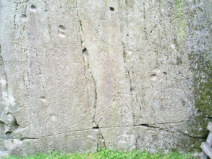
Second big rock from the gate – main decorative wall.


First big rock from the gate. So obviously pecked, like all the rock art at Copt Howe. Recent chalk on the rock shows that bouldering is still taking place, but this rock wouldn’t be obviously carved to anyone uninterested in prehistory.
From the Shap Community Website.
From the Shap Community Website.


This recent visit was on Whit Saturday, 2005. Typical bank holiday weather. The news said it was 33 deg C in London yesterday, 6 deg C on the Lakeland fells today – worlds apart. It was a day of gales, with storm force gusts, blowing me over several times. Add to that the horizontal rain, which arrived just as I reached the circle, and the photos don’t do justice to the grimness of the scene.
Set in a valley head, with the Roman road of High Street on the ridge to the east, and the Moor Divock circles and cairns to the NNE, the only open aspect is to the N. The stones are recumbant now, but possibly once stood. The western sector has no stones, or they are burried under grass tussocks. To the SW of the circle two pairs of stones seem to form an avenue.
The circle is hard to spot, lost in acres of grass and marsh. It doesn’t help that the stones aren’t standing. If you don’t know the area it will be hard to find, and the O.S. map shows it slightly further N and W.

Looking back NW to Swarth Fell stone circle from the SE.


