Reached here with Pie Eater, just after visiting Brats Hill. We’re even more confused, due to the nearness of Brats Hill, plus the strange wall that looks like an enclosure. Also by the two circles. What went on here? Today all was peaceful, and had a nice feeling. But I’ve been here when the clouds are low on the fells, and a cold rain rakes across Burnmoor (one word, not two), and then the mystery of the place is all pervading, and a sense of doom pervades. Woooooo.
The Eternal
Reached this from Boot. After hitting the ridge, and not wanting to miss anything, we thought we knew best, me and Pie Eater, knowing these wild places of Cumbria like we do. A wearisome plod though deep tussocks saw us overlooking Brats Hill and White Moss. We descended to Brats Hill and found the path we should’ve stuck to if we had had any sense, but adventurous souls will always be adventurous souls, untethered by the constrictions of the modern world. Hmmmm. We noticed a few cairns, dug out(?) in the centre. This circle had a good view of White Moss. We were impressed by the number of large stones comprising the circle, all in surroundings of grass. They must’ve taken some dragging. We were also impressed, as always, by the bulk of Scafell, our next objective, rearing its head in omniprescent steepness to the north. A quiet place. Why here?

Lookin S through White Moss NE circle, with the SW circle in the background to the left.
Image credit: The Eternal

White Moss, inside the NE stone circle, looking to the SW stone circle.
Image credit: The Eternal

White Moss NE stone circle, looking NW to Illgill Head.
Image credit: The Eternal

Wall enclosure-type feature on the E side of White Moss stone circles, looking NW.
Image credit: The Eternal

Wall enclosure-type feature on the E side of White Moss stone circles, looking SW.
Image credit: The Eternal

White Moss circles from Brats Hill. Looking westwards to the shallow col between Whin Rigg (left) and Illgill Head (right).
Image credit: The Eternal

One of the cairns within the Brats Hill stone circle. Looking SE, with Harter Fell in the background.
Image credit: The Eternal

Brats Hill stone circle looking to the the S side. My mate, Pie Eater, composes himself to a photographic quiescence, tries to hide his newly acquired weight, all the while adding a sense of scale to the scene. One of the central cairns is in the foreground.
Image credit: The Eternal

Brats Hill stone circle. Approaching from the SW, over deep grassy tussocks (off the path), with the bulk of Scafell rising ahead.
Image credit: The Eternal

Looking eastwards from Loft Crag, over Thorn Crag and the water-worn chasm of Dungeon Ghyll, to the buttresses of the west face of Harrison Stickle. One of its stone axe factories lies below the crags of the south face.
Image credit: The Eternal
Lying between the Thorn Crag and Pike of Stickle stone axe factory sites, this site, one of many on Loft Crag, has been unearthed by the passage of feet on the popular Langdale Pikes. As well as many greenstone flakes and chips on the path and scree, there are also flakes and chips sticking out of the peat that has been eroded by walkers.
This is just part of a huge complex in Great Langdale.
Having read about this site, I knew where to look. Right on the brink of the drop into the depths of Dungeon Ghyll, these quarries appeared as hollows in the ground. Amongst the untouched natural rocks were greenstone blocks, flakes and chips, showing much evidence of stone working. The fact that I have only ever seen these in stone axe production areas highlights the authenticity.
The greenstone is a striking, clean colour, and the site is set amongst magnificent mountain scenery. Across the dark declevity of Dungeon Ghyll the craggy face of Harrison Stickle (another peak with axe factories) rises in steep, grey butresses, soaring high above.
Over the edge, before the final plunge into Dungeon Ghyll, there is another short slope, full of scree, and documented as containing more evidence of stone axe production, but I didn’t visit that, as I was speeding towards Loft Crag and, finally, the Pike of Stickle stone axe factory.
There’s always next time

Thorn Crog stone axe quarries. These are hollows in the ground, two of which appear stone filled. A third appears as stone overgrown with grass. Greenstone chips and flakes are in abundance, but don’t show too well in the photo. A close-up I took was cocked-up by dodgy focusing. Soz about that.
Image credit: The Eternal

Thorn Crag and Loft Crag stone axe production sites on the approach from the NE (from the SW shoulder of Thunacar knott).
Image credit: The Eternal

Fussell’s Lodge reconstruction drawing. A long barrow of timber construction, now only visible as marks in the soil and/or crop.
Image credit: From the National Trust Guide to Prehistoric and Roman Britain by Richard Muir and Humphrey

Mickleden cairn with the imposing Pike of Stickle stone axe factory in the background.
Image credit: The Eternal

Two Mickleden cairns in foreground and left of sheep. I wonder if it’s one of Hob’s “Sheep of Doooooom”?
Image credit: The Eternal

Two Micklden cairns below the Pike of Stickle stone axe factory. Were they robbed for contributions to the drystone wall?
Image credit: The Eternal

Edge of large bracken covered cairn in Mickleden, directly below the Pike of Stickle stone axe factory, at a rough grid reference of NY271065.
Image credit: The Eternal

Looking down on lovely Mickleden and its cairn-field, from Loft Crag, the peak just E of Pike of Stickle.
Image credit: The Eternal
The other day I decided to say sod it and go down the Pike of Stickle scree. We’re not really supposed to do it, and I’ll probably be criticised for it, but never mind. I trod carefully, at least as carefully as you can on sliding rocks.
The journey was part of a longer day on the hills, and I also visited the Thorn Crag and Loft Crag stone axe sites. I think all the Langdale stone axe sites should be split up into independant sites under the banner of “Langdale Axe Factory” on TMA. For instance, there’s sites over on Bow Fell.
Anyhow, all the sites had much evidence of stone flakes and chips. Lovely greenstone, once the surface has been removed. The Pike of Stickle scree held an amazing amount of this evidence. It has to be seen to be believed.
The man-made cave had lots of smaller stone chips – evidence of a certain amount of basic finishing of the axes, or of working of the cave? The cave was aproximately 5 to 6 feet wide, 7 feet deep, and 7 feet high.
The descent to the valley was interesting to say the least.

The end of the voyage. Preferable to it being the start. The Pike of Stickle stone axe factory in all its glory.
Image credit: The Eternal

Looking up the river of rocks that is the Pike of Stickle stone axe factory scree debris. Yes it is steep.
Image credit: The Eternal

Looking up the Pike of Stickle stone axe factory scree debris.
Image credit: The Eternal

Looking back up to the Pike of Stickle man-made cave.
Image credit: The Eternal

Fissure in the Pike of Stickle man-made cave, showing evidence of stone chipping.
Image credit: The Eternal

Looking to the back wall of the Pike of Stickle man-made cave.
Image credit: The Eternal

Pike of Stickle man-made cave wall, showing evidence of the rock having been worked.
Image credit: The Eternal

Small greenstone chippings and flakes on the floor of the Pike of Stickle man-made cave.
Image credit: The Eternal

The Pike of Stickle man-made cave.
Width approx. 5 feet to 6 feet,
height approx 7 feet,
depth approx 7 feet.
Image credit: The Eternal

Looking down on the Pike of Stickle man-made cave.
Image credit: The Eternal

An edge worked onto the stone, found amongst the debris in the position shown, halfway down the Pike of Stickle scree.
Image credit: The Eternal

At the side of the Pike of Stickle scree there are fewer rocks. Here I still found evidence of stone axe production, with flakes and chippings of the greenstone, amongst the other natural rock. Most of the scree is comprised of stone flakes and chippings.
Image credit: The Eternal

Looking down the Pike of Stickle axe factory scree. Mickleden below. It’s as steep as it looks, but more unstable, like a waterfall of rocks.
Image credit: The Eternal
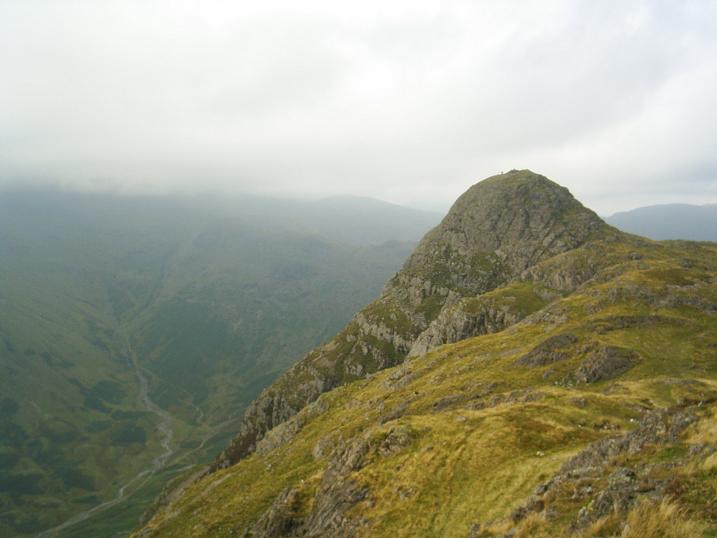
Pike of Stickle from Loft Crag, which also has an axe factory site. The Pike of Stickle axe factory scree is at the bottom of the rock face directly below the summit
Image credit: The Eternal

Approaching Pike of Stickle from the NE. The entrance to the axe factory scree is in the col below the obvious steep wall on the left of the peak.
Image credit: The Eternal

Fussell’s Lodge long barrow reconstruction, photographed at Salisbury museum.
Image credit: The Eternal


Avebury NW quadrant, showing male and female stone forms.
Image credit: The Eternal
What an unusual place. Iron Age, but not a fort? Doesn’t seem to fit in with anything. Gives a feeling more of the Neolithic.
Any road up, it’s worth a visit. The photos don’t do justice to the fantastic position, or the panorama, especially down to the Bourne Valley and Salisbury.
The central area is vast, the banks and ditches deep and high. A huge number of man-hours must’ve been required in its construction.
It remains an enigma, but I feel we should be looking to the Neolithic for answers. Oh, and a few more excavations too, please.

Figsbury Ring, looking across from the NE entrance.
Image credit: The Eternal

Figsbury Ring NE bank.
Image credit: The Eternal

Figsbury Ring, the NE entrance. Salisbury Cathedral in the centre.
Image credit: The Eternal
What a place to get away from the mess and crowds of Stonehenge. Just to sit here and think, knowing someone of great importance was buried here. What ceremonies took place on this spot all those years ago?
There is a feeling of great open space, both on ground and in sky. The burial mounds stretch away in most directions, and the wind seems to whisper the secrets of the past as it sighs through the grasses.
A place for solitary contemplation, with a great feeling of the deep past.

Normanton Down barrows, Bush Barrow’s eastern neighbours from the NNW.
Image credit: The Eternal


Normanton Down barrows, looking SE from Bush Barrow.
Image credit: The Eternal

Normanton Down barrows, looking E from Bush Barrow.
Image credit: The Eternal