
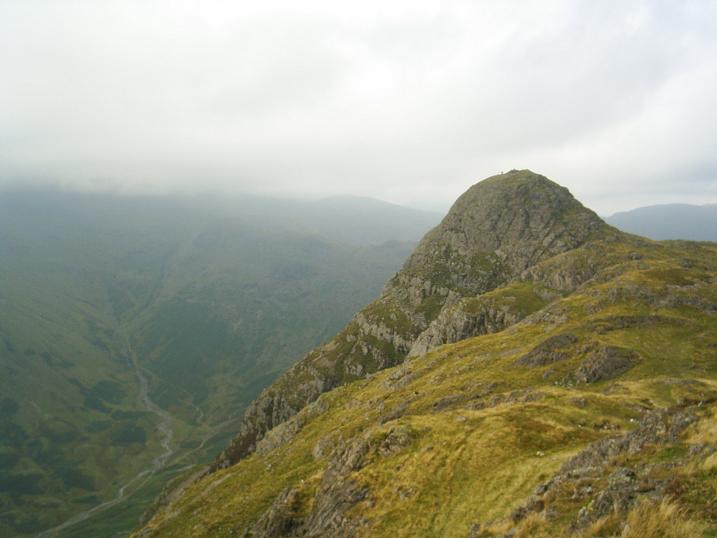
Looking eastwards from Loft Crag, over Thorn Crag and the water-worn chasm of Dungeon Ghyll, to the buttresses of the west face of Harrison Stickle. One of its stone axe factories lies below the crags of the south face.
Image credit: The Eternal
Looking eastwards from Loft Crag, over Thorn Crag and the water-worn chasm of Dungeon Ghyll, to the buttresses of the west face of Harrison Stickle. One of its stone axe factories lies below the crags of the south face.

Thorn Crog stone axe quarries. These are hollows in the ground, two of which appear stone filled. A third appears as stone overgrown with grass. Greenstone chips and flakes are in abundance, but don’t show too well in the photo. A close-up I took was cocked-up by dodgy focusing. Soz about that.

Thorn Crag and Loft Crag stone axe production sites on the approach from the NE (from the SW shoulder of Thunacar knott).

Fussell’s Lodge reconstruction drawing. A long barrow of timber construction, now only visible as marks in the soil and/or crop.

Mickleden cairn with the imposing Pike of Stickle stone axe factory in the background.

Two Mickleden cairns in foreground and left of sheep. I wonder if it’s one of Hob’s “Sheep of Doooooom”?

Two Micklden cairns below the Pike of Stickle stone axe factory. Were they robbed for contributions to the drystone wall?

Edge of large bracken covered cairn in Mickleden, directly below the Pike of Stickle stone axe factory, at a rough grid reference of NY271065.

Looking down on lovely Mickleden and its cairn-field, from Loft Crag, the peak just E of Pike of Stickle.

The end of the voyage. Preferable to it being the start. The Pike of Stickle stone axe factory in all its glory.

Looking up the river of rocks that is the Pike of Stickle stone axe factory scree debris. Yes it is steep.

Looking up the Pike of Stickle stone axe factory scree debris.

Looking back up to the Pike of Stickle man-made cave.

Fissure in the Pike of Stickle man-made cave, showing evidence of stone chipping.

Looking to the back wall of the Pike of Stickle man-made cave.

Pike of Stickle man-made cave wall, showing evidence of the rock having been worked.

Small greenstone chippings and flakes on the floor of the Pike of Stickle man-made cave.

The Pike of Stickle man-made cave.
Width approx. 5 feet to 6 feet,
height approx 7 feet,
depth approx 7 feet.

Looking down on the Pike of Stickle man-made cave.

An edge worked onto the stone, found amongst the debris in the position shown, halfway down the Pike of Stickle scree.

At the side of the Pike of Stickle scree there are fewer rocks. Here I still found evidence of stone axe production, with flakes and chippings of the greenstone, amongst the other natural rock. Most of the scree is comprised of stone flakes and chippings.

Looking down the Pike of Stickle axe factory scree. Mickleden below. It’s as steep as it looks, but more unstable, like a waterfall of rocks.
Pike of Stickle from Loft Crag, which also has an axe factory site. The Pike of Stickle axe factory scree is at the bottom of the rock face directly below the summit

Approaching Pike of Stickle from the NE. The entrance to the axe factory scree is in the col below the obvious steep wall on the left of the peak.

Fussell’s Lodge long barrow reconstruction, photographed at Salisbury museum.


Avebury NW quadrant, showing male and female stone forms.

Figsbury Ring, looking across from the NE entrance.

Figsbury Ring NE bank.

Figsbury Ring, the NE entrance. Salisbury Cathedral in the centre.

Normanton Down barrows, Bush Barrow’s eastern neighbours from the NNW.


Normanton Down barrows, looking SE from Bush Barrow.

Normanton Down barrows, looking E from Bush Barrow.

White Sheet Hill Neolithic causewayed enclosure banks to the right of picture, with BA round barrow at ST802351. Viewed looking SW.

White Sheet Hill Bronze Age cross dyke looking WSW.

White Sheet Hill Bronze Age round barrow at the western point of the hill. Grid ref. for the barrow ST800351.

White Sheet Hill Bronze Age round barrow from the W,
Grid ref. for the barrow ST802351.

Wor Barrow reconstruction and finds. Photograph taken at Salisbury and South Wiltshire Museum.

“Found in barrow 5K on Net Down, Shrewton, at the bottom of an oval shaft, cut 3 metres deep into the solid chalk. He was buried clasping his beaker. His bone-pommelled bronze dagger was placed on a chalk block, and has stained his left forearm green. A broken piece of an antler pick, used to dig out the chalk, was abandoned in the shaft (top left). The chalk blocks formed a kerb for a low mound, heaped over the body, (at the bottom of the shaft) immediately after burial.”
Quote from Salisbury and South Wiltshire Museum. Picture taken there.

Tyrebagger (Gap) stone circle. reconstruction, photographed at Salisbury and South Wiltshire Museum.

Distant, frantic Stonehenge from the peaceful haven of Bush Barrow. Get away from it all, under big, busy skies. Appreciate the landscape without instructions and gift shops. Leave the wife in the car if you must.

The archer buried in the ditch at Stonehenge, taken at Salisbury and South Wiltshire Museum. Try and ignore the reflection of the strip light.

Beckstones rock art site, the rock art is under the first tree, right of centre. Viewed from the N.
Kirkstone Pass is the gap in the hills just left of centre.

Beckstones, obliquely from the S.


Beckstones, looking down from the SW.

Beckstones, looking down from the E.