
fitzcoraldo

Who, that has not seen, but has heard of Roseberry Topping? – The pride of northern England – familiar as household words to a wide and wealthy district – a subject of enquiry and wonder unto all who have for the first time looked upon its isolated and lonely magnificence, its gigantic cone, like some eastern pyramid, now lit up, glowing suddenly as a huge furnace, now black and bare, its narrow peak shooting abruptly into the sky, the very image of solitude and desolation. No wonder that its neighbourhood is the deposit of many of those grotesque and fearful legends, arising out of, and connected with, the most ancient of our superstitions; and that the almost universally exploded belief in supernatural agency, witches, fays, and all their subsidiary marvels, should linger in these comparatively untraveled recesses, unquestioned and undenied.
The opening lines of The Witch of Roseberry Topping or the Haunted Ring.
Blackwood’s Magazine.
1835
Available via Google Books.


Quote from the forum
’ We think that the large white house in the centre of the picture is Brimpts Mead, which is now very enclosed by trees and not really visible (the entrance to its drive is just up the hill from Pixies Holt). It must have been quite new then, but I think may not be so bright white now.
Brimpts Farm would be off to the right, but you can see the main road cutting across the top of the picture on front of the forestry trees, you can see where it turns, on the map there is a spot height of 293m at this point. As most of the Dartmoor plantations were planted around 1920, this dates the photo to after that – not sure how long it takes for the trees to mature.
The building in the top left are at Hexworthy but I don’t know which ones – maybe the pub?
On the left you can see the road of Dartmeet hIll, with a track running to the right to Dartmeet Bungalow (may have had a different name then – but was named this when a prominent DTRG member Peter Hirst who co wrote the Brimpts book lived here until he died a few years ago).
Tim says the circle in the photo is visible from the road, at GR SX 676 734 – if it was Ollsbrim you wouldn’t be able to see the track to the bungalow so easily, but you are right, it is a round house not a stone circle!
Image credit: Chapmen & Co. Dawlish

Postcard ‘photographed in natural colour‘
Date unknown
Postcard reports ‘RAIN AGAIN‘
Image credit: Webster. Keswick

Postcard
Posted 1962
Image credit: Valentine's Post Card

Postcard
Date Unknown
Image credit: Kent's Viking Series


Postcard
Date Unknown
Image credit: The Nothern Photographic Company. Glossop / Stubob


The Glaisdale Rigg Stone looking across Glaisdale Head to Egton High Moor.

The Rokan Stone looking down into Glaisdale with the Esk Valley and the North Sea beyond. The tract of land to the left is Glaisdale Rigg.
This is a large boulder just on the edge of Billy’s Dyke.
It has a number of possible cups plus natural cups and a large basin. I have have added it because it is mentioned in the book ‘Rock Art and Ritual’ by Smith and Walker.
There seems to be a little confusion with the name of this boulder, Smith and Walker state that it is known locally as the Cheddar Stone, the Magic Map has it marked as the Cheshire Stone.
Whatever the name it’s a cracking spot to sit down, have a brew and take in the views.

Looking across Bilsdale towards Garfit Gap with Cold Moor on the left and Urra Moor on the right.

The unusual holed boundary stone on the top of Green Howe.
Looking north east-ish towards Cringle Moor on the left and Cold Moor on the right


Sadly this stone has suffered a little since I was here last. Some bright sparks have carved their names into the side of the boulder.
Rich mentioned that there may be a plan to site a stile over this stone. The sooner the better I reckon.


Looking North-ish towards the other carved rocks in this area.

Whilst searching the Pinder Hawes Hill area of Skyreholme I came across a stone with a small, worn cup mark on it. I though little of it and mentioned it in passing to Greame.
On passing the stone Greame decided to lift the turf whilst making some throw-away remark that there was probably a pristine cup lurking below the turf...
Bugger me, he was right! Up came the turf to reveal a lovely large fresh-looking oval cup.
As far as we know, this is a new discovery the credit for which rests firmly with Greame C.


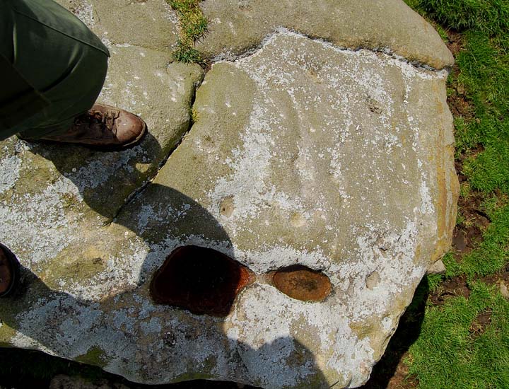
Stone 418
The book, Prehistoric Rock Art of the West Riding states that this rock has 5 grooves, 1 cup with 2 rings, 3 cups with single rings plus another dozen or so scattered cups.
Erosion is obviously taking it’s toll on these carved stones as we could barely recognise many of these features.

Stone 422 looking south across High Skyreholme to Simon’s Seat.
Ray Seaton’s Astronomical significance chart indicates that this is the direction of the winter solstice sunset.
Stone 422 looking west.
The conical profile of Elbolton Hill is visible on the horizon. According to Ray Seatons astronomical significance chart for 2000BC, this is an alignment on the spring equinox sunset..whatever that means.
The bloke in the field is the mighty Graeme C.

A hastily grabbed shot of a few of the cups and bowl on the top of rock 421.


Rock 407 looking west with the conical profile of Elbolton Hill visible in the distance


An old postcard credited to Frank Packer, photographer, Chipping Norton.
Image credit: Frank Packer

an uncredited old postcard
Image credit: uncredited
Magic mountain yields jade axes
A nice article about the three-year project, JADE, which has investigated the production, distribution, use and meaning of Neolithic jade axeheads.
timesonline.co.uk/tol/life_and_style/court_and_social/article6497835.ece
This ruined burial mound sits overlooking Malham Cove. Arthur Raistrick describes the mound as being ‘three quarters removed at the time of the enclosures.‘
There is still enough of the cairn remaining to identify the site so it’s worth looking out for if you ever visit the cove. Access is fairly easy although you can’t walk right up to the cairn. It can be viewed from the side of the cove once you climbed up the many dozens of steps and tottered across the lovely limestone pavement.
Arthur Raistrick described this site as a sub-rectangular Bronze Age house. Prior to his excavation the site was ‘almost covered by scree on three sides’.
I had hoped that there may have been something left to see as Raistrick described the structure as being built of boulders.
On my visit I couldn’t find a trace of the site
Seaty Hill
Not a lot to see on the ground, best viewed from the hill opposite, Abbot Hills, where the ditch and bank are more obvious.
Easy access from the track from Malham Cove or better still the footpath from the wonderful Gordale Scar. Either way a high stile over the wall is involved.
On the top of Seaty Hill is a shallow ditch and bank enclosing a low mound 66ft in diameter.
On excavtion it was found that 2 holes had been dug into the mound, one of which contained a crouched burial. Raistrick classified the mound and burial as Bronze age.
13 secondary burials had been inserted into the suface of the mound and were thought to be early Iron Age. A bone pipe was found in one of these burials. The pipe had been fashioned from a sheeps tibia which was perforated with three finger holes.
Source
Archaeology of Malham Moor
Arthur Raistrick and Paul F. Holmes