
A Guidebook for Carn Euny can be bought at Chysauster. You do not have to pay to go into Chysauster just to buy the guidebook.
For some strange reason I have never visited Chysauster before....is it cos you have to pay! No..can’t be that, I flashed my Tour Guide badge and got in for nothing.although I did by a book.
I chose a great day to visit, the sun was shining, the whole site bedecked in flowers, gorse and foxgloves prominent. The only slight problem was the easterly wind...but this did at least mean that the casual visitors didn’t stay long.
There was more to see than I thought, and much easier to decipher what’s what than at Carn Uny (although the guide covers Carn Uny as well). There are 9 houses to explore, in different stages of preservation and after a while they all start to follow the same pattern, eastern entrance, courtyard, bay on the left, long room on the right and round room opposit entrance. Each house has at least one “stone with hollow”, not allways in the original position and most have the remains of water channels, lines of stones running down across the courtyard.
I know English Heritage come in for critism sometimes on this site but I have to say I was happy with the way Chysauster was presented. Yes there are info boards dotted around the area but they are not too intrusive..and not everybody wants to buy a book. The gray hut at the eastern end could be moved a bit further away from the main village. I was not sure if it was a tea shop at busy times or where the lawn mower is kept. That was another thing, the site was tidy, the grass was short in the houses but the flora was allowed to grow elsewhere. Some clearence of gorse has taken place, but all in all there was a nice ballance.
Good clean toilets at the car park..nice to know if you are walking in the area.

..and he’s not hiding behind either....
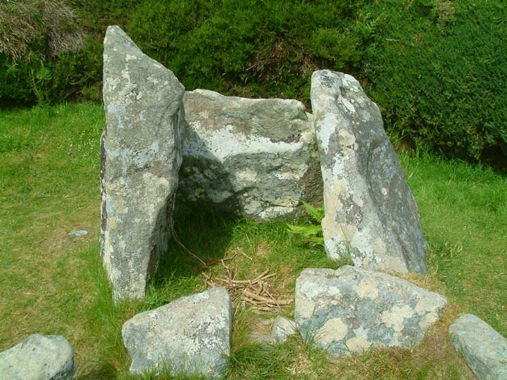
This structure in House 3B was at first thought to be a hearth..but excavations revealed no evidence of burning. There is a suggestion in the guide book that it may have been altered in modern times to provide a platform for Methodist preachers.

One of my favourite rooms at Chysauster, the small round room of House 6. Borlase found evidence of a fire and pottery here.

Possibly one of the original door jambs to House 7. It is thought this house has seen many changes over the years with at least three entrances into it now instead of the usual one.

Three stones in the courtyard of House 7 looking towards Penlee Point

One of the many “Stone with Hollows” that can be found on the site. The lady at the gate..and the official booklet.. did not want to confirm that they were querns saying that they could be the holes that the central posts for the house roofs sat in.

This photo of a stone on the left side of the entrance to House 3B is supposed to show cup marks....however they are very faint ...if not impossible to see unless you know where they are!
26.5.06
You wait nearly 30 years to get back into a site...and you are met by thick mist!
As a young army cadet I spent several weekends at the MOD camp at Penhale...with no interest in history. Now that I am a big boy I finaly get to go back in on a fieldtrip to look at landscape (sand dunes).
Walking down through the radio station at the north end the low banks of the Iron Age cliff castle were pointed out to us...through the mist...I was not allowed to go too close so the only photo is the best I could get.
Who knows what the strange hoops are that sit inside the banks...the MOD guy had no idea!
The SWCP runs the other side as far as I know but they were keen to stress that trespassers are not tolerated!
Mr H

Strange radio things sit inside the earthworks...thick mist and an MOD escort made getting a decent photo difficult.
Wonderful place to explore if you want to escape from people! Real mixture of landscapes from flooded pits to mysterious swamps where lichen and ferns add an almost prehistoric feel to the place.
Although much of the wetter bits are covered by boardwalks it is advisable to go in wellys or boots.
Can’t find any documentary evidence on this one, but....
Unless you knew it was there it can only be spotted from the bottom of the permissive footpath that exits RedMoor nature reserve and climbs to meet the Saints Way. Once you start climbing it is hidden by gorse bushes and once on the Saints Way the banks are so high you can see nothing.
It’s a big stone!...and just outside the area enclosing Helman Tor. An ancient trackway passes just down slope from it and in the hedge/scrub behind is a large dump of granite that has been cleared from the field. Why was this stone left?
So, I can not prove its origins or find a record of it on maps or any of my books...but it feels right!
I have now had it suggested to me that this stone has been moved from elsewhere in the field...and that they had dowsed the field and found an area with a stone setting in it...
Go look for yourself..and while you are there enjoy the “prehistoric” wildness of Red Moor reserve.


Brown Gelly is one of those hills you see from miles around...and notice that it has features on top. Right of access has always put me off climbing it, but now that it is open access I decided to take a stroll up onto the summit on a glorious May afternoon.
There are a couple of gateways along the Dozmary Pool-St Neot road that give access to the hillside and then another couple of gates give access into the summit field.
Please use them and don’t go scrambling over walls or fences.
The top of the hill is reasonably flat and featurless, several wet areas are best avoided and it is only the southern end that has rocky outcrops.
Along the ridge run five cairns, the size of which you only realise once you get up close.
At the northern end a large cairn has had its top compleatly taken away and the inside scooped out. Uninterupted views of Dozmary Pool and Brown Willy and Roughtor can be had from the cairn.
The second cairn I found the most interesting. I suppose it would be called a ring cairn..but on a giant scale. The outer bank is about 3 ft high with a depresson about 4 or 5 ft across inside of it before reaching the central mound. The central mound has been dug into deeply, and looked like it might be holding water...I didn’t investigate.
The central cairn is the largest and I would think about 15 ft high. It stands proud on the hill with steep sides and a good dome shape. Although there has been some excavation on the summit it is not too severe.
The fourth cairn is a mess. It has been dug into and pulled about and is just a low pile of stones. A Trig point stands beside it, built onto what looks like a base of stones taken from the cairn.
The last cairn at the southern end has again been dug into but not to the extent of cairn 1 or 4.
Sitting on the side of the hill that eventually becomes Brown Gelly, I can not find any info on this earthworks to date it. Marked on the OS map as a three sided square, the south east side was not visable but may be over the wall.
So, what is left?
Two low ridges with a shallow ditch on the outer side, all getting eroded by cattle. As can be seen in one of my photos there is some stonework remaining at the north east end.
Access is by a gate off the Dozmary Pool to St Neot road and is on open access land.

Expanse of water in background, Colliford Reservoir
Looking SW

SW view along right side bank of earthworks

Looking NW towards Brown Willy and Roughtor.
Just to the east of the huge Boconnoc estate in east Cornwall sit a group of 6 or so barrows. They may be linked to the Taphouse barrows on the other side of the estate, the two groups between them certainly form a impressive collection of large barrows.
The Buckabarrows stretch out along the eastern boundry road of the estate. The four photgraphed here are joined on the OS map by two others, one deep in the woods at SX166607, which I never got to and one supposed to be in a field at SX174611, which I failed to spot.
Bucka or Bucca is a Cornish word for ghost but i have not come across any tales about these barrows being haunted....barrowwrights in Cornwall! ......there’s a thing!

The two most prominent of the group on top of Buckabarrow Downs.


The most northerly of the barrows, this one sits just beside the minor road after it leaves the B3359. Give it a week or so and it will be a mass of bluebells.
I have been intrigued by the Giants Hedge for many years...Living in Looe at it’s supposed eastern end I could never understand why it was called giant..it is just like any other hedge...more like a bank as it runs through Kilminorth Woods beside the West Looe river.
It is only when you see it towards its western end at Lerryn that you realise it is no ordinary field boundary.
But when does it date from?...the general consensus is that it is post Roman...so it really should not be on here, but...
There are several Iron Age and older settlements inside the hedge (between it and the sea), but then again there are a good dozen or so barrows just to the north of it....but none as grand inside.
Walking along the top of a short section of it this morning i noticed how good the view was across the Cornish countryside. It does in many places run along the side of a steep escarpment..and if topped off with a wooden fence would have been quite impenetrable.
Whatever it’s history, I’m sure no giants were involved in its building.......just some very hard working Cornishmen of old.
...and I would love to know where the bit is that’s 8 yards across !


On top of the Giants Hedge
Reported to be the best bit of the hedge in existence..or the most accessible...
Willake Woods, above Lerryn
..just visible, the circle known as the Trippet Stones, 105 ft in diameter with nine stones in situ and the rare adition of a central stone.
“Is there not some ancient lettering on the central stone?” I asked ” a C or a G?”
The farmer smailed. ” I mind the time” he said, “when that C was put there by Mrs Collins, the landlady”
C Lewis-Hind: Days in Cornwall. Methuen 1907
I have just received the minutes from Penwith Access and Rights of Way Forum (Feb 2006)
In them it states that the access gate on the permissive path to Boscawenoon (sic) stone circle has been repaired and rehung and that the definitive path has been trimmed back hard of brambles and gorse by local volunteers and a new way marker installed at the start of the path.


