

Intriguing site this one. 3 stones in a field, two very flat, one more rounded, set in a very large triangle. RCHAMS list it as Springhill Standing Stone, yet call it the remains of a circle, and schedule only a single stone and a wider area where a second may be. What about the other two? Farmer standing his field clearance on end? I’d like to know.
Worth a visit, the stones are excellent, and the views are, as ever, superb.
Access: On a minor road south of Kirkton of Skene. Visible from the road, which is just wide enough and just quiet enough to park carefully on. Opposite a gate, and 200m across a field. Visit in Autumnn/Winter to avoid growing crops.


Quite straight forward to find, especially if you have an OS map (a neccessity in this part of the world, as there’s so many sites to find. Can someone buy me a whole set pretty please?)
The forest track you need is directly opposite the entrance to Glassel House. Big gates, very much of the ‘get orf my land’ type I chickened out and parked 100m up the road by the log piles (Sunday, no trucks about). If you look on the OS map, you will see the circle clearly marked parallel to the track, and there is a contour line that passes through the track to the circle. Simply walk down the track until it starts to dip down, turn left through the trees for 100m and you’re there. The site sits on the edge of a steep slope, so once you hit that, you know you’re near. I’ve also added a photo showing an old field wall & gate on the forestry track. Stop about 10 m short of them and you can turn left here and walk through.
The site? Nice, very compact and very different. A peaceful setting and a pleasant feel make this an essential site. As Greywether says, don’t classify it, just enjoy it.

The gate & old field wall on the forestry track. Once you see these, stop approx 10m short, turn left and walk for about 100m. The circle should be right in front of you.

The nicest and in this weather, one of the most apt names for a circle. The still strong September sunshine drifted around these warm pink stones and it really could have been any century, any millennia.
Largely whole (and wholly large!) you can imagine this to be an important site at the time of its construction, with the massively cup-marked recumbent adding weight to this. The recumbent has fallen and such a large piece as broken off, it almost looks as if it hit the ground with a crash. Strangely though, and like Tyrebagger this only seems to improve the site.
Access easy and as described, and a big thanks to the farmer for making it so. They don’t have to, and they certainly don’t always.


A possible second outlier, just south of the Balblair stone? The standing stone is in the background.
My 4th visit and I can’t believe I never noticed the graffitti on the recumbent! (Seems I’m not alone)
I can’t make out much, looks like 1864, some initials and....? Its right on the top, near the right flanker (from inside the circle). Anyone who can decipher it better, let me know.
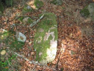
Also in the woods near the northern Balblair stone I found a suspiciously long stone lying in the grass, just to the south of the menhir. Could be a gatepost, and after a day in the field you do start to see megaliths everywhere, but it raised my suspicions.
I do like this site, and I guess we should be grateful that it still remains-especially after visiting Kinellar Kirkyard earlier in the day.
A member of an archaeological team working under the direction of Josh Pollard made an exciting and significant find at the most recent excavation at Woodhenge (Wilthsire, England). The discovery was of a large piece of bluestone from the Preseli Mountain Range in south Wales. Read more
From Stonepages.
Note the split on the tallest stone in the foreground. This ‘splinter’ has now fallen. The mound has also been restored.
What a gorgeous circle.
And what a change in a county of countless recumbent circles. Don’t get me wrong, I love the RSC’s but this was like rinsing out the mind before going back to them. Everythings just that little bit different – the raised mound is so much more noticeable, mainly I suppose because the circle is not hemmed in by a fence like so many others. You can really feel this circles place in the landscape-it seems like the centre of it.
Beautiful stones too, with quartz and lichen just dripping from them. The tallest has been split by the elements providing you with a launch ramp to the sky (as my 4 year olds told me).
Kudos to all those involved in the restoration (Which you wouldn’t know about just being in the circle) and to the farmers for looking after it. These circles were built by the farmers for the land, and they seem to appreciate the care by their descendants-if only it were true everywhere.
Access: I’m with Greywether. Park at the monument car park and walk-its how the builders would have done it. Besides, I would not want to see my tyres after driving down the last 300 yards of rough stone track – tyre-bagging time ;-)


Just one more sky against the countless thousands that have looked down on this megalith.


Quartz nodules protrude from most of the stones, but this was exceptional.

Why is no-one coming here? If its because its restored don’t worry-its as good as Loanhead & East Aqhorthies, and at least it was carried out by Aubrey Burl, a man who knows.
Strichen is a complete restoration – aside from damage in the distant past, it was destroyed and hurled in the nearby quarry in the 1960’s. Due to local outcry and the efforts of Dr Burl & Co. the site was excavated and restored as near as dammit in 1981/2.
And a good job they’ve done. A classic RSC on a hill with the wide open views all around. The recumbent has a deep hole drilled into it, reminiscent of those made prior to dynamiting, but who knows who, why or when? One of the circle stones has fallen recently by the looks of the ground. It may have been pushed, but to be honest the socket doesn’t look deep enough or the packing stones sufficient.
Access: Now improved. From the main road into Strichen, head for the community park, near the old railway track. A new sign of the Aberdeenshire Councils ‘Stone Circle Trail’ style points the way down Brewery Road. About a mile further on, another one points you left into a small parking place adjacent to the old railway. Park here, and follow the signs down, under the railway bridge, and up a good all weather track to the circle. About 10 minutes walk. You can still access via the country park, which is also a nice place to spend an hour or two.
Come visit, theres no excuse!

The old Strichen Hall as seen from the circle. Didn’t last long (relatively speaking)


