


Gorgeous! My new favourite.
.o0O0o.
Just off the A1, had to stop as I passed!
These stones are huge spikes – *very* tall and impressive.
One is captive in a small fenced area (what has it done to deserve that?)
Over the other side of the road are the other two, which today were in a newly-sown field so couldn’t get closer.
.o0O0o.


This stone was brought into the Durham Rock Art Conference on 8-3-2003 in the back of someone’s car. The delegate had found it in a stream near Longframlington, and was now in a carrier bag, so there’s no point in trying to find this one :-) Stan Beckensall got very excited about it.
One side is green and more weathered. The other side is very well-preserved, with clear pick marks. There is a large chunk missing.
Comments were made on the way the green side used a natural line in the stone to look like a face ?!
Unfortunately these are the best of my photies.
.o0O0o.

sunstruck, 23-2-2003.
.o0O0o.

Taken 7-3-2003.
Little white blob.
.o0O0o.

Taken 7-3-2003.
Covered in white lichen!
.o0O0o.
It’s Friday it must be Barrow – hmmm let’s look at the map – woohoo! Get thee ter t’stones.
Up a very steep, dark, wooded road, an old quarry, then look – the sky! And Hey! Stones! Wow! Cool.
.o0O0o.


Taken 7-3-2003.
Looking across Morecambe Bay
.o0O0o.
1-3-2003
After staying the night in Robin Hood’s Bay village, popped up here first, but took the long way round Doh! No problems with sheep, in fact they ran when they saw me, can’t think why.
Lovely morning, sun shining, nice view of the bay, a skylark above singing away, I mean you’d think it was spring!
.o0O0o.


View towards Robin Hoods Bay
1-3-2003
.o0O0o.


Are these prehistoric carvings? Answers on a postcard please
1-3-2003
.o0O0o.

Another possible couple of cup-marked stones, in a wall near the pointy bit, behind a tree.
1-3-2003
.o0O0o.

Possible cup-marked stone, in wall next to steps.
.o0O0o.
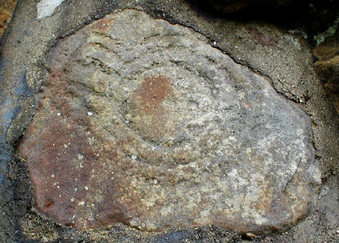
The main item of interest. Found just above head height near the little man-made cave.
1-3-2003
.o0O0o.
There were signs everywhere asking non-residents to obtain a ticket at reception for the grounds, so in I went, and they let me in, which was nice. I asked for directions to the rock art and they pointed me towards the battlements.
After a wander around when all I could find was a few questionable cupmarks and a pair of newlyweds, I returned to reception for more clues. It’s beside the little cave, they said, to the right. And there it was, just above head height. Very hard to miss unless you know what you’re looking for, a bit faded and even looks a bit two-dimensional. And if there are more pieces, I couldn’t find them!
As it is very close to the little cave (see misc notes on history of Raven Hall) perhaps this area of the wall can be dated to between 1829 and 1845.
Also, I saw, way above head height, some more markings in the cliff face that looked a bit like cups marks. I discounted them as they were so high up, but if you think about it, if they blew up some of this cliff who’s to say they didn’t used to be accessable? Just a thought, and I’ve posted the pic anyway although it isn’t very good quailty being so far away.
Very impressive place – the gardens will be nice in the summer. Worth a trip for the views. Lovely.
.o0O0o.
Summary of information contained in a leaflet available at the hotel, “The history of Raven Hall”
Raven Hall was built in around 1763, when the remains of a Roman fort were found on the site. It was built by the owner of the local Alum Works for his family holiday home. It remained in the family after his death in 1829, when it became a retreat for George III and “various other loopy royals”. The original owner’s grandson, an eccentric Vicar, created the incredible hanging terraced gardens and battlements by literally blowing them out of the cliff face! Included in this project was a small but useful cave…
Needless to say, in 1845 this owner became financially unstable, and the ownership passed to the bank owner, who took on the role of local benefactor and landlord.
Quite a tall stone, has some pretty old-looking graffitti “FS”.
.o0O0o.


Taken 23-2-2003. The more westerly outcrop, actual position NT971371.
A strange circular shape, appears to have been cut rather than natural.
Angular marks on the side of it too? About 3 feet in diameter.
((O))

Taken 23-2-2003. The more westerly outcrop, actual position NT971371.
((O))
23-2-2003.
Lovely feel to this one, in a small wood, which also houses the steep ramparts of a fort.
After here walked to Goatscrags and then on the way back visited the waterfall, in a wonderful dingly-dell. To get to the waterfall, follow the track towards the farm for approx 100m, and there is a well-worn path down beside a stream, follow this down (but watch your footing!) to caves and falls.
There was a yellow VW van parked up and signs of camping in the woods…with a microphone on he dashboard. What’s JC driving these days? :-)
.o0O0o.

Taken 23-2-2003. The more westerly outcrop, actual position NT971371.
Cheviot behind the mist.
((O))
23-2-2003.
Followed the track up through Routin Linn farm, and it’s on the hill to the west of the crags. The paths are well-used by horse riders so access is relatively easy. There are two outcrops marked on the map, NT973372 and NT971371.
They are worth the trip up, I loved this site!
To the Goatscrags end of the hill, there is a sheltered quarry-type area, which I am sure has a hollow next to it as if it’s been a burial mound there. Lots of geographical reasons why this could be the case?
.o0O0o.

Taken 23-2-2003. Near the more easterly outcrop, actual position NT973373. I’m sure this is a burial cairn of some sort.

Taken 23-2-2003. The more easterly outcrop, actual position NT973372.
((O))

Taken 23-2-2003. The more easterly outcrop, actual position NT973372.
View to the south, with Doddington Moor to the left and The Cheviot to the right (behind the mist!)
((O))

Taken 23-2-2003. The more easterly outcrop, actual position NT973372.
Cut through by a line of more weather-resistant quartz.
((O))


Taken 23-2-2003. The more easterly outcrop, actual position NT973372. One of the largest carvings I’ve seen, boot for scale:-)
((O))
I parked at Gefrin and walked back down the hill. The stone is a good seven feet high, and a granitey beast!
.o0O0o.


Taken 23-2-2003. With monument behind, to the north-west.
.o0O0o.


Taken 23-2-2003. With Yeavering Bell behind.
.o0O0o.


From National Park leaflet:
“Legends and nameless shadows hover around Simonside as surely as the mists that cling to its heather-clad summit. If Simonside ‘has its hat on’ most people in Rothbury expect rain. A few also half-believe stories of dwarfs and will-o’-the-wisps, and are reluctant to set foot on the hill whatever the weather.
Recent archeological research suggess that there has always been something special about Simonside. Prehistoric flint arrowheads, bronze swords and axeheads, pottery and ornaments have all been found here. In the bronze age the lower slopes were farmed but Simonside itself was not; instead it was a place for cairns and barrows, for spirits and remembrance.”
“Hidden in the forest there are burial cairns and cists, carved stones and ancient pathways. There are also dozens of rock outcrops with caves and overhangs...”