
Taken 2nd August 2003: The cairn from the direction of the footpath (that would be the west).
Image credit: Simon Marshall

Taken 2nd August 2003: The cairn from the direction of the footpath (that would be the west).
Visited 2nd August 2003: Why is everyone in such a rush to get to Barclodiad-y-Gawres? This little cairn (or tumulus depending on who you ask) is on the way, and well worth the detour (a detour of about 3 meters from the footpath). The remains of a cist are clearly visible in the middle of what’s now a rather flattened mound.
NB. It’s tempting to keep stepping backwards trying to get a photo of the cairn with the sea behind it, but be careful of the quarry that has been dug just to the east of the site.
Don’t let the appalling acronym put you off. This is a really useful web site containing rural and countryside information from a number of Government agencies including English Heritage.
NB. The MAGIC map is designed for use with Internet Explorer 4.0, Netscape Navigator 4.6 or higher and a screen resolution of 800x600 pixels or higher. This is not a site for modem users either.
Visited 2nd August 2003: Even though we approached from the west, we went to see Trefwri (east) first. It’s not enormously tall, but pleasingly proportioned. It has quartz seams running along it’s length, and a heavy strata visible on the sides and top of the stone. It looks good and old. This Trefwri stone stands closer to Afon Braint than it’s neighbor.

Taken 2nd August 2003: Viewed from approximately the east.

Taken 2nd August 2003: Scouting ahead, I got to the stone before the others. As they came round the corner of the forestry plantation they startled some geese, which took off and flew into my photo. This shot is taken from the south.
Visited 2nd August 2003: After Trefwri (East) we doubled back to it’s bulky and broad neighbor, Trefwri (West). It’s not entirely clear whether this stone originally stood upright, or whether it’s always been longer than it is tall. In places it’s shot with brilliant quartz, but from a distance the stone looks a dumpy and dowdy. Like it’s partner, the location of the stone near the river (Afon Braint) is interesting.

Taken 2nd August 2003: A close-up of the eastern edge of the stone, showing the veins of quartz that run through it.
I’m not aware of a name for this stone, so I’ve called it Trefwri (West) after it’s neighbour, which is listed on CARN as simply ‘Trefwri Standing Stone’.

Taken 2nd August 2003: Looking south west(ish) towards the lane.

Taken 2nd August 2003: Viewed from the south west. Between the stone and the trees runs a small stream called Afon Braint.
Visited 2nd August 2003: We went on to Castell Bryn-Gwyn after Bryn-Gwyn Tre’r Dryw, by which time the sun had come out again. It was lunch time, so we had a picnic on top of one of the banks. After the food William and I played rolling down the bank. This is a great place to hang out, and I’d recommend it as a picnic spot.

Taken 2nd August 2003: The bank to the west of the site, with William for scale (he’s just over 1 meter tall). The gap in the bank that William is standing on appears to be ancient, but whether it’s part of the original design is anyone’s guess.

Taken 2nd August 2003: Viewed from near the modern entrance to the site, looking north west.
The Cadw sign at the entrance to Castell Bryn-Gwyn says,
The nature of this site is uncertain although it may have originally been a religious sanctuary. The earliest bank and ditch belong to the end of the neolithic period (2500-2000 BC) but the site was re-occupied and fortified in Roman times and later.
On the ground it’s easy to see why everyone is so cagey about defining this site.
Visited 2nd August 2003: Ever since I first read about them, I’ve been fascinated by these stones, and at last I’ve got to visiting them. It’s no secret that they’re big, but you have to stand next to them to get a real idea of just how big. They’re much larger than anything else in the area, and standing next to them you can’t help wondering about everything that’s been lost here. This is an excellent place. I’ll definately be back.

Taken 2nd August 2003: From the east, giving an indication of how thin the western stone is.

Taken 2nd August 2003: Viewed from the south east.
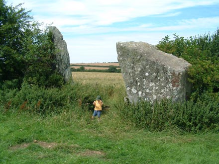
Taken 2nd August 2003: From the east (or there abouts) with William standing next to the stones (approx 1 metre tall).

Taken 2nd August 2003: From (approximately) the south west, with Plas Newydd in the background.

Taken 2nd August 2003: The chamber from the south, with the drive in the background.

Taken 2nd August 2003: The chamber viewed from the direction of the house (approximately east) with the National Trust coffee shop secreted behind the capstone on the left.
There’s a solitary boulder visible to the right of this shot. It’s on the other side of the track nearer the gatehouse. I would have liked to have taken a closer look, but circumstances didn’t allow.
Visited 2nd August 2003: Based on my experiences working on another estate, I decided we could just brazen it out, so long as we were confident and polite. We drove up the drive in our clapped out Fiat Uno, and parked behind the trees near the house. I left the others in the car (Lou doesn’t share my taste for this sort of thing) and strolled up to the chamber.
The chamber is beautifully proportioned. You can really see why some people mistook it for a folly. I didn’t go inside, because that would have looked a bit weird (not in keeping with my “I’m supposed to be here” persona). I did my best to look academic, and strolled around the taking it all in.
On my way back to he car I nodded and smiled to a National Trust bloke in a minibus. He looked at me a bit strangely, then grinned back and waved. All the cloak and dagger stuff is fun, but there really should be better access to this site. It’s a darned sight more important than the house. Even carefully controlled access on a regular basis would be better than the current situation.
From an article by Alan Hamilton, published in The Times, on 3rd September 2003:
Cryptic runic symbols discovered on a block of granite in Norfolk, initially thought to be of huge archaeological significance, have been found to be just eight years old.The newspaper carries a photo of the Mayor of Great Yarmouth proudly studying the carving, and another of Mr Luxton carving the symbol (page 11). Great stuff!The two-tonne rock, imported from Norway in the 1980s to strengthen sea defences at Gorleston-on-Sea near Great Yarmouth, was exposed this year by high tides. It was engraved with intertwined serpents and runic symbols which, it was felt, had a definite 2,000-year-old Norse look about them. Dr John Davies, chief curator for North Norfolk Museums, declared it unlikely to be a fake.
“It looks genuine; not the sort of design someone would doodle,” he said. The town’s local newspaper reported a “potentially very important discovery” — but the sculptor then confessed. Barry Luxton, 50, an unemployed construction worker with an interest in druids, said that he cut the design with a hammer and chisel over three days in 1995 to coincide with May Day celebrations.
“It is hilarious that they were taken in,” he said yesterday. “I certainly did not intend to deceive anyone.”
The Ananova version of the same article is also entertaining.
Visited 25th July 2003: On my way to my brother’s Stag do, I detoured into Welshpool to find Maen Llog. At first I got the wrong church, and when I eventually found St. Mary’s Church, parking turned out to be a bit tricky. One of the two gates into the churchyard was locked, but once I’d found a way in the stone was obvious.
Maen Llog is very polished, presumably by people standing on it for various reasons, over the centuries. It looks rather inconsequential, standing as it does among the gravestones. Worth a visit if you’re in the vicinity, if only because of the numerous rituals attributed to it.
Clwyd Powys Archaeological Trust list Maen Llog in its current position, as a ‘boulder’ of unknown date. It’s antiquity must be in doubt, as nobody else seems to list it. It really doesn’t look much like a standing stone (Barber’s hunch), but it does remind me of a photo I’ve seen of Carreg Pumpsaint which is thought to be a possible anvil stone (Roman or Medieval). This is just supposition of course.

Taken 25th July 2003: The stone from (approximately) the south.

Taken 25th July 2003: Maen Llog now stands between an old lamp post and a sundial outside the church.

Taken 25th July 2003: Looking approximately south, down Salop Road.
In his book More Mysterious Wales, Chris Barber writes:
Standing in the churchyard [of St. Mary’s Church, Welshpool], this hunk of stone is reputed to have stood formerly in the abbey of Strata Marcella (SJ25131042) where the abbots were ‘installed’ on it as part of a well established ritual.
After the Dissolution of the monasteries Maen Llog was moved to St. Mary’s Church, and a new ritual grew up around it:
Folk who were required to do penance were made to stand on the stone, dressed in a white sheet, with a candle in one hand.
The stone was moved into the graveyard on the instruction of a Puritan called Vovasour Powell, who considered it to be an object of superstition. It sounds like Powell was right, because the stone came to be used as a wishing stone. To make wish, you have to climb it and turn three times to face the sun.
In his book Mysterious Wales, Chris Barber tells the following Arthurian legend about the stones:
These stones, about 25 feet apart, are said to be a monument to King Arthur’s sons who were killed by the Twrch Trwyth, a wild boar which caused havoc in his camp. It had originally swum over from Ireland. The story is told in great detail in the Mabingion. On the ridge above are Cerrig Marchogion – the stones of Arthur’s Knights.
Presumably Cerrig Marchogion is Bedd Arthur, but I’ve not seen it referred to by this name before.

Taken 25th July 2003: From right to left, the peaks of Moel y Golfa, New Pieces and Breiddin Hill, as viewed from just south of Trewern.
According to Coflein there’s a round cairn, 12m in diameter and 1.0m high, within the defenses of Cefyn y Castell (SJ30531332).
Visited 17th July 2003: After successfully finding Hoyle’s Mouth Cave I decided that I had time to find it’s neighbour, Little Hoyle Cave, before the coach left Tenby. I walked up the road, and over an enormous cattle grid onto the private driveway that leads to the Golf Course.
The cave is on private land, so strictly speaking there’s no public access without permission. I found that a cheery wave seemed to work whenever someone drove past, and after a bit of walking (and some waving) I took the plunge and followed the GPS into the forest. It really was a nightmare in there, with brambles and stinging nettles up to head level. Progress was slow, and I got it wrong quite a few times before I found the cave. I got stung to bits, and it wasn’t nice. Don’t try this in the summer!
The cave isn’t all that far from the drive, but impossible to see until you’re right up next to it. As the name suggests, it’s smaller than Hoyle’s Mouth, with a lower, rounder area inside. Although I had no torch, I could go to the back of the cave because the roof has fallen, letting enough sunlight in to see by. This time I really did feel like I was in a place where very few people go. I didn’t stop for long for fear of getting left behind, which was a good job because it took longer to get out of the forest than it had to get in.

Taken 17th July 2003: Inside the cave, looking in towards the area where the roof has caved in.

Taken 17th July 2003: The cave entrance, which isn’t all that easy to find.
This photo is from a page containing a couple of aerial shots enterpretted in different ways. The site is called Manx Archaeology, by David J. Radcliffe.
Photos and a description of this site, as well as directions.
A good sized page about this “the largest known megalithic tomb on the island”, including photos and directions.
Not the most desciptive page on this site, but it does include two photos and directions.
A page about this enigmatic little site, thought to be either the remains of a cairn or hut circle.
A page about the tomb explaining it’s rather sad history, and recent change of location. Also directions and photos.
A page about the tomb, including a comprehensive set of directions and photos.
Visited 17th July 2003: I was supposed to be on a work jolly to Caldey Island, but when we arrived in Tenby we found that boats weren’t sailing (no explanation). After a few hours in the pub, I made my excuses and walked south west out of town to find Hoyle’s Mouth Cave and Little Hoyle Cave.
First off, I’d recommend against visiting either of these sites in the summer, because the foliage is thick, and you will get stung by stinging nettles! There’s no signposting to Hoyle’s Mouth Cave, so a GPS is handy (even then you’ll be guessing). There are a lot of tracks through the woodland, and eventually I hit upon one that went up to the cave.
I don’t usually go for pre-Neolithic sites, but circumstances brought me here, and it was pleasantly surprising. I hadn’t brought a torch with me, so I didn’t venture too far into the cave. Sitting in the entrance looking out over the damp vegetation that I’d struggled up through, I felt rather sublime. The peace and quiet was lovely. The cave is obviously used by local kids, because there were the remains of a camp fire in the entrance. What a great den!

Taken 17th July 2003: Looking into the cave. I’d not had the sense to bring the torch with me, so I didn’t go much further in than this.

Taken 17th July 2003: Looking out of the cave entrance. My rucksack is on the floor to the left, giving some idea of scale.

Taken 17th July 2003: The cave entrance. I suffered greatly at the hands of gigantic stinging nettles to get this shot!

Taken 16th July 2003: The western stone viewed from the south west, with the beautiful village of Bow Street just visible in the distance.

Taken 16th July 2003: Viewed from the west with IGER and the eastern stone (marked in red) in the background.

Taken 16th July 2003: Viewed from the east .
