
Taken 9th December 2003: Relatively new wooden steps cut into the defensive bank on the north side of the fort (surely a bit dodgy, especially given the small number of visitors that the site gets).
Image credit: Simon Marshall

Taken 9th December 2003: Relatively new wooden steps cut into the defensive bank on the north side of the fort (surely a bit dodgy, especially given the small number of visitors that the site gets).

Taken 9th December 2003: From the bottom of the defensive ditch on the north side of the fort, looking approximately west along it.

Taken 9th November 2003: Another shot in the morning sunshine, this time from the east.

Taken 9th November 2003: Mynydd March in the morning sunshine on my way to work. This view is from the north east.

Taken 9th November 2003: The stones viewed from the north east, lit up by the morning sunshine. I took this photo on my way to work.
Visited 11th October 2003: Easy to find and relatively easy to get at. We asked about the stone at the museum, and although they couldn’t help at the time I got some information from them through the post (currently ‘misplaced’). Not exactly a megalithic wonder, but if you’re in the Peterborough area then you’re not spoilt for choice.

Taken 11th October 2003: The stone viewed along it’s edge.

Taken 11th October 2003: Louise demonstrating how darned small the stone is, through the combined mediums of mime and modern dance (I think I may have promised not to publish this one).

Taken 11th October 2003: Taken with the museum behind me.
Visited 23rd September 2003: I was initially drawn to Carreg-y-Bwci because, on the Landranger map, it looked like a round barrow with a name. Also, as I had Alfie with me, it had the extra appeal of being near the road.
I parked just to the north of the site near the cattle grid, and walked up to the site. Although I’d done no research at this stage, it was pretty obvious from the beginning that something was a bit unusual. The boulder in the centre of the site is enormous, and unlikely. It could almost be a natural rock, incorporated into the site. The tight surrounding circular bank is well defined and rounded (almost feminine). Smaller stones lie on one side of the site, looking almost like kerb stones. I was just totally stumped as to what I was looking at.
Definitely worth visiting if you’re near Lampeter, if only to ponder the meaning of it all.

Taken 23rd September 2003: Looking into the ‘donut’ with the the enormous stone lodged inside.

Taken 23rd September 2003: Showing the central stone, and the largest of the stones that lie just outside the earthwork (in the foreground).

Taken 23rd September 2003: From close-up, here is a slice of the site.

Taken 23rd September 2003: Carreg-y-Bwci viewed from the north. This is the best shot I could get of the overall site (not an easy place to photograph).
This is an enigmatic place, described as a possible round barrow (Cadw & Cambria Archaeology), chambered tomb (Cambria Archaeology), Roman watch tower (RCAHMW & Cambria Archaeology), enclosure (RCAHMW) and standing stone (Cambria Archaeology).
Carreg-y-Bwci consists of a mound with a large hollow in the centre of it (similar to a donut on its side). In the middle of this is a large prostrate stone. Not an easy site to interpret, but certainly something special. It is sited on a ridge at the head of the river Ffrwyd Cynon.
The ‘Roman watch tower’ theory has gained some credence because Carreg-y-Bwci sits on an old Roman road (Sarn Helen). This doesn’t seem very conclusive to me, as the Romans had a habit of intentionally running their routes past existing megalithic sites (or re-using existing trackways). Also, Carreg-y-Bwci isn’t at the highest or even second highest point in the area. I know very little about Roman watch towers, but I would have thought a vantage point without the obstruction of nearby hills would be sensible.
In it’s modern form the Roman road marks the boundary between Ceredigion and Carmarthenshire. There’s a possible stone circle 1km to the north west in Coed LLwynifan (SN63754838).
Visited 23rd September 2003: This cairn is a bit of a mess, but represents the last survivor of a number that once stood in the area (according to the NMR). There’s a gateway opposite the cairn, but the cairn material isn’t easy to see without taking a closer look.

Taken 23rd September 2003: The cairn, looking east (or thereabouts).

Taken 23rd September 2003: Possible kerb stone or remains of a cist? Either that or a just a large stone incorporated into the cairn.

Taken 23rd September 2003: Bryn Goleu viewed from the south west (the direction of the road).
If you have a spare £70,000 in your back pocket, then here’s your opportunity to buy a genuine Bronze Age round barrow (or what’s left of it). Swanborough Tump is on the market along with Frith Copse, the 17 acre plot of semi-mature woodland that it stands on.
The agents, Woolley and Wallis, have yet to put anything on their web site about the sale, but further information is available on request. They describe the tump as, “marked by a low mound topped by an information pillar”. So much for Estate Agent spin.
In a recent edition of Making History on Radio 4, Dr Oliver Padel described the Tristan Stone as a possible converted standing stone. Apparently the inscription on the stone is similar to other 6th Century inscriptions in Cornwall and Wales. He was relatively happy to entertain a connection between the stone and the Tristan of legend, but emphasised that there was no definite link between the stone and the story. Nothing surprising there I guess.
Visited 23rd September 2003: The area around Hirfaen Gwyddog is very rural, so I was a bit surprised to find a lorry maintenance depot directly to the south east of the stone. Here I asked about access, and they invited me to park the car in the yard and walk up to the stone over the fields behind them. With Alfie on my back I headed off, expecting more of an uphill slog than I got.
As the hill leveled out we saw the stone, sitting unassumingly below the horizon on a field boundary. Two gates later we were there, and it didn’t seem understated any more. The stone itself was magnificent, lit up by bright sunshine against a troubled sky. The strange diagonal markings near the tip of the stone looked like gills, and the point of the tip was sharp like a shark’s nose. Not a shape I’ve ever seen before, and clearly chosen for the shape by the people who erected it. I was pleased to see that the barbed wire I’d seen looped around the stone in photos was gone (nice new fence as well).
Alfie played while I took photos from every angle I could. It was addictive, and I didn’t want to leave. Every time the clouds moved, the light changed, and I needed to take more! What a fantastic place. Must go back soon!
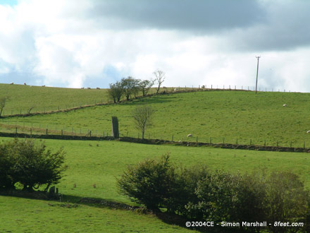
Taken 23rd September 2003: The stone in its surroundings, viewed from the south east.

Taken 23rd September 2003: The dynamite holes described by Cope after his visit in 1997. You can’t help but wonder why the stone is still standing after all that work went into drilling these.

Taken 23rd September 2003: The shark-like tip of the Hirfaen Gwyddog, complete with gills. Viewed from the south west.
According to Cope (The Modern Antiquarian – page 296), Hirfaen Gwyddog has a written history dating back to the 8th Century CE when it was called behet hirmain in the Book of Chad. In a 12th Century CE charter it was referred to as Hyrvaen Gudauc, and in 1633 CE it was called Hirvaen gwyddoc by Edward Lhuyd.
Hirfaen Gwyddog stands on the county boundary between Ceredigion (historically known as Cardiganshire) and Carmarthenshire. It also marks the point where the land of three farms meets. In his book Mysterious Wales Chris Barber describes the stone as ‘the tallest standing stone in Dyfed’. I’m not sure whether this is true or not, but at 4.8 meters it must come close.

Taken 23rd September 2003: The stone viewed from the north east (the Ceredigion side of the fence).

Taken 23rd September 2003: Hirfaen Gwyddog viewed from the south east. The fenceline running left to right is the county boundary between Ceredigion and Carmarthenshire.

Taken 28th August 2003: Here’s a close-up of one of my photos, with arrows indicating apparent cup marks corresponding with those shown in the 1927 photo. If these are the missing cupmarks, then the National Monument Record is not correct, because it states that the marks are “buried in the soil beneath the concrete plinth”. I’ve contacted English Heritage, and they are looking into it.

Taken 28th August 2003: The top of the stone with vertical grooves caused by weathering/sacrificial blood/arrow sharpening (delete as applicable).

Taken 28th August 2003: The stone viewed from the east. In the background is Booker Avenue.

Taken 28th August 2003: Robin Hood’s Stone viewed from the south east. This is the side of the stone that originally faced south.
MAGIC (Record No.: 23692) describes the site as the remains of a destroyed Neolithic chambered tomb, now arranged in the form of a stone circle:.
The monument is known as the Calderstones, a group of six decorated sandstone monoliths thought originally to have formed part of a Neolithic chambered tomb constructed approximately 4,000 years ago. These stones have been removed from their original context and are now arranged in a circle and located in the vestibule of Harthill Greenhouses in Calderstones Park. They display an abundance of prehistoric rock carvings and were closely examined by Forde-Johnston in 1954 after their removal from an earlier location close to the entrance to Calderstones Park where they had been erected for display in 1845. They were erected in their present location in 1964 and placed in a random order.
The eight digit grid reference for this site is SJ40408761.
MAGIC (Record No.: 33891) states that Robin Hood’s Stone was originally part of the ‘the complex of stone monuments known as the Calderstones‘, but it doesn’t suggest it was part of a stone circle.
The stone was formerly erected during the Bronze Age and was originally part of the complex of stone monuments known as the Calderstones, which lie approximately 150m to the north east. These have been protected as a separate monument (SM 23692).
The record goes on to describe the cupmarks and give dimensions for the stone:
An early photograph shows that the stone had been decorated with several cup marks, similar to those recorded on the Calderstones. These marks are now at the base of the stone, buried in the soil beneath the concrete plinth. The standing stone is approximately 2.4m high, 0.9m wide and 0.4m thick. It is set in an oval concrete plinth, 0.2m above the surrounding pavement, which is 3.2m long and 2.6m wide.
Interestingly the ‘plinth’ is part of the scheduled site. The eight digit grid reference for this site is SJ39978638.
Visited 20th September 2003: We visited the barrow on a circular walk, but if you wanted to see it for its own sake access is reasonably good. The nearest road is only half a mile away, and the barrow itself is on a public footpath.
Round barrows are quite unusual in this area (round cairns are much more common), but Gelli is one of a small selection that have survived. There’s a relatively modern hedge bank (minus the hedge) running through the barrow, so from some angles it looks very wrong. The lack of cultivation in the area means that the barrow mound is still quite large, but I have no recollection of seeing a surrounding of ditch.
Not a spectacular site, but a nice enough place to visit if you’re based in the area. The gradient from the road to the barrow is relatively shallow, but the path isn’t good enough to get a wheelchair up without some difficulty.
As an aside, I only realised after our visit that Gelli is visible against the skyline from Banc Bwa-Drain, so now I get to see it on a regular basis (as a tiny lump in the distance).

Taken 20th September 2003: Looking north east, down the relatively modern hedge bank, towards the barrow. William is on top of it waving a stick (for some reason).

Taken 20th September 2003: Viewed from the west, with William giving some indication of scale (he was 4 years and 4 months old at the time).

Taken 21st September 2003: This shot is intended to show one of the hut platforms within the defenses of Castell Bwa-Drain, in this instance being used for a picnic. This platform is cut into the slope on the eastern of the highest outcrop, presumably placed here so that it would be sheltered from the prevailing wind (also the case at Pendinas).
In the foreground is Richard, William and the two babies (Alfie and Felix) plus Bob the dog. In the distance is Banc Bwa-Drain, with it’s little windfarm (a very good place to view Castell Bwa-Drain from). The buildings above everyone’s heads are Bwa-Drain farm.
The sorry looking bronze plaque in front to the stone reads:
THIS MONOLITH KNOWN AS “ROBIN HOODS STONE” STOOD IN A FIELD NAMED THE STONE HEY AT A SPOT 19 FEET DISTANT, AND IN A DIRECTION BEARING 7 DEGREES EAST OF TRUE NORTH FROM ITS PRESENT POSITION, TO WHICH IT WAS MOVED IN AUGUST 1928. THE ARROW BELOW INDICATES THE DIRECTION OF THE ORIGINAL SITE.
THIS.SIDE.OF.THE.STONE.FORMERLY.FACED.SOUTH
Pretty informative for something so old, and at least they recognised that the stone’s orientation was potentially important.
Visited 28th August 2003: Robin Hood’s Stone is no longer in its original position, having been moved to accommodate housing development in 1928. It now stands behind railings on the corner where Archerfield Road meets Booker Avenue (the grid reference is less accurate than this description). An accompanying plaque explains the stone’s origins (see below).
The side of the stone that originally faced south now faces south east. It originally stood approximately 60 meters away to the north, presumably inconveniently situated where a nice ‘modern semi detached house was planned (otherwise it would have made a lovely garden feature). The top of the stone is weathered into vertical grooves.
Visited 27th August 2003: Signposted from the A25, a tiny dead-end road runs past the field where Arragon Moar Circle sits. The road is only really used by farm traffic, and you’d be forgiven for thinking it was private. There’s an absence of any signage to tell you where to stop once you’ve left the A25, so a map is very handy.
About 1km along the road it changes direction (turning south) and there’s a gateless gateway into a field straight ahead of you. This is the best place to park and view the circle (and it’s neighbor, Arragon Mooar Burial Cairn) from afar, or get a closer look by continuing on foot. When we visited Arragon Moar the field had recently been ploughed, and everywhere was really dry and dusty in a Holy Land kid of way. We parked up, and tramped through the dust to the circle.
Of course it’s not really a stone circle (there aren’t any true stone circles on Mann), but the site does consist of a close circle of relatively large orthostats sticking up out of a mound. Once this was a burial cairn, but now it may as well be an embanked stone circle, the end result is so darned close.
The views out to sea from Arragon Moar Circle are spectacular, especially looking south west towards Langness. If Arragon Mooar Circle and Arragon Mooar Burial Cairn are related to each another, then the circle must represent the burial of a superior chief/priest because it’s got a much better position (in my humble). High up, overlooking the sea in one direction and the rolling fertile landscape in the other, it’s a potent place to put a tomb. Well worth a visit, but like so many of the sites on Mann, not even slightly wheelchair friendly.
Visited 27th August 2003: Arragon Mooar Burial Cairn isn’t as accessible as Arragon Moar Circle (presumably you’d need the farmer’s permission to visit it). From the road it appears to be smaller and less dramatic. The two sites are intervisible and it seems likely they’re part of the same cemetery. Our ‘visit‘ was more a case of admiring from afar (from the point where the small road to the south of the site bends sharply south). For details of where to park etc see my fieldnotes for Arragon Moar Circle.
Two photographs of Robin Hood’s Stone and some information (towards the bottom of the page).

Taken 27th August 2003: Viewed from the south east.

Taken 27th August 2003: William sitting inside the circle. Not a fantastic photo, but the only one I have that gives an indication of the size of the thing (the circle I mean, not William).

Taken 27th August 2003: One of the stones on the southern side of the circle.

Taken 27th August 2003: Louise and William standing behind (and ‘on’) some of the enormous stones on the north western side of the circle.

Taken 27th August 2003: The Arragon ‘circle’ viewed from the north east. Obscured behind the burial mound (but clearly visible from the site itself) is the strange headland of Langness.
From an article on the BBC News web site by Paul Rincon, published 28th April 2004:
The Neanderthals reached adulthood at the tender age of 15 according to a report in the journal Nature.
French and Spanish researchers analysed growth records preserved in the teeth of Neanderthals, modern humans and two other human species.
Breaks in the deposition of crown enamel reveal how fast teeth grow.
Neanderthals formed their crowns 15% quicker than we do, reaching adulthood when modern humans of the same age were still floundering in adolescence.
Visited 27th August 2003: By the time we reached Port Grenaugh, everyone was tired, especially William. It was very hot and sunny, and the last thing he really wanted to do was walk up any kind of gradient. Ice creams were mentioned a lot, but there was no van.
The cliff top path up to Cronk ny Merriu isn’t all that bad, but there’s a stile to get over that will cause problems for anyone with mobility problems. There is a bench along the way for resting though (which William made use of).
The fort isn’t very large, but it’s dramatically situated above the beach. Once inside we kept a t tight reign on Will (Alfie was safely on my back) because there are sheer drops on three sides of the fort. The rampart is large, and tucked in behind it are the remains of a Viking house. It’s worth walking off along the footpath to the east to get views of the fort from that direction. From here you’ll see the rampart apparently joining up with a natural rock promontory running up the cliff side (badly explained, but I know what I mean).
After visiting the fort we played on the beach. In the sunshine this was jsut the trick (even without ice ceams). In most other respects, Cronk ny Merriu is not very kiddy friendly (not small kiddies anyway).