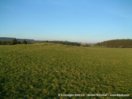
Taken 11th January 2003: Looking approximately north, with both barrows almost aligned. A third barrow lies to the north east, surrounded by forestry.
Image credit: Simon Marshall

Taken 11th January 2003: Looking approximately north, with both barrows almost aligned. A third barrow lies to the north east, surrounded by forestry.

Taken 11th January 2003: This is the southern barrow, taken looking west. The low winter sunlight helps bring out some of the contours.

Taken 11th January 2003: From the west, with the farmer heading back across the field on his return journey.

Taken 11th January 2003: Looking north west towards Pentrefynys farm.

Taken 11th January 2003: The stone and it’s mud, with William (age 3 and a half if you’re thinking about scale) examining his boot.

Taken 11th January 2003: Looking east through a gap in the hedge that I was tempted to try and squeeze through.

Taken 11th January 2003: From the north west this is the view of the stone from the road.

Taken 10th January 2003: This is the memorial from the south.

Taken 10th January 2003: Looking south east, this is the War Memorial in the village of Penrhyn-coch. The quartz boulder with the cross on the top of it was formerly a standing stone.

Taken 10th December 2002: This is the tumulus like lump shown in the other two photos I’ve posted. There’s no sign of any cairn material here, and tumuli aren’t unprecedented in the area.
This time the hill in the background is Disgwylfa Fawr (big for the area at 507 metres, but not exactly Alpine in proportions).

Taken 10th December 2002: This photo is taken from the road looking south west over Y Garnedd. Two of the cairns are visible in this shot (cairns or tumulus, it’s debateable). I’ve marked them with red arrows because they’re a bit tricky to spot.
In the background is Afon Rheidol, and to the left is Dinas. There’s another obvious cairn just off the shot to the left, and I understand there are more that I’ve not yet identified.

Taken August 1997: Looking south east towards the Watchstone and the Stones of Stennes. In the distance you can see Barnhouse.

Taken August 1997: This is the Watchstone looking nort west towards Brodgar. I’m not sure what the origins of the smaller stone on the right are.

Taken 20th July 2002: I realise this is shameless advertising for Mr Radley, but when we knocked on his door and asked for directions he was very friendly, and this is a good landmark when you’re trying to find the footpath.

Taken 4th January 2003: This is the stone viewed from the gate at the end of the field (i.e. looking north west). Sheep placed carefully for scale.

Taken 4th January 2003: This is the stone from the road (you can see a strand of barbed wire running across the shot). This is about as close as you can get without getting permission.

Taken 2nd January 2003: Here’s a slightly blurry shot of two of the stones that are visible. They’re not quite two foot long, so they would make pretty poor standing stones, even by my north Ceredigion standards.

Taken 2nd January 2003: This is the site from the north west, complete with feeding trough (there’s no extra charge to see the feeding trough). You can just make out two of the stones in the bottom right hand quarter of the photo.

Taken 31st December 2002: This shot shows the north west corner of the enclosure, where there’s a possible secondary entrance.
I took the photo to show the BMX track that has been made here. In case you can’t make it out, there are three rows of ditches and obstacles in the foreground (including a sofa). I’m not sure how much damage has been done by this little bit of random digging, but it can’t be good for a site to have people cutting chunks out of it.

Taken 31st December 2002: Looking up the north east side of the enclosure (so the M1 is just out of the shot to the right).

Taken 29th December 2002: By the time we got this far we were soaked, but still having fun. This is William (age 3 and a half) standing next to one of the boy stones. Coming from the direction of the henge this stone is the last on the right hand side before the road starts to intersect the avenue.

Taken 29th December 2002: I’m not sure what the numerical identity of this stone is, but it’s about half way around the south west quarter of the circle. In the background (to the right of the stone) is the famous Red Lion Inn.

Taken 29th December 2002: This is the first stone you come to (in the south west quarter of the circle) if you approach from the big National Trust car park. I’ve been trying to find out what number it is, but no joy. Obviously it’s been pieced together after some pretty serious damage was done to it.

Taken 29th December 2002: There were winter crops in the field surrounding Adam and Eve, so we couldn’t get very close. Considering the amount of rain and the poor light, this photo came out better than I expected.

Taken 29th December 2002: The wall of the chamber was littered with tea lights, and the accompanying soot and wax.

Taken 29th December 2002: On our way to Avebury we were passing Gwernvale, so I insisted on stopping to show William. It was much as I remembered it, but this time I was struck by the original size of the tomb, indicated by the small concrete markers.

Taken 19th December 2002: OK, so this is pretty cheesy, but here’s my Christmas offering to the site. Garreg Fawr is built into the top of the wall in the foreground. The Christmas tree in the background is one of two standing in the village of Llanbadarn Fawr (that’s more than Aberystwyth has, so perhaps they’re trying to say something).
Ho ho ho, merry Christmas etc etc!

Taken 10th December 2002: A self portrait taken looking north west with the camera balanced precariously on one of the stones. It was very cold and windy, so I was expecting the camera to be blown away before the shutter went off.

Taken 10th December 2002: Looking down into the depression inside the circle. This was probably made by treasure hunters.

Taken 10th December 2002: The circle looking west, across the Rheidol Gorge. The mountain on the horizon is Disgwlfa Fawr, which has a large Bronze Age cairn on it’s summit.

Taken 10th December 2002: This is the circle viewed from the north east, with Afon Rheidol running across the background, and Dinas in the distance.

A friend of mine emailed me this picture a long time ago, but I’m not sure where they got it from. I think we can safely assume it’s copyright free though (I’m guessing that the picture predates the stone’s destruction in 1814).

Taken 10th December 2002: This is a view of Dinas from the south west, across the delightfully named Bog Pond (a 19th Century mining reservoir). The fort itself is difficult to see from most angles, and even more difficult to photograph once you’re right up next to it. In this photo you can just make out some of the defences (a slight step to the left of the summit).
In the far distance in Pumlumon Fawr, Ceredigion’s tallest mountain (752 metres). It’s capped with three Bronze Age cairns and the Rheidol Gorge between it and Dinas is littered with burial sites. The Iron Age builders of Dinas would have been aware of this, and it may have been a factor in their choice of the location for their fort.

Taken 17th December 2002: This is the view I had to endure during this afternoon’s coffee break. Pendinas is on the left hand side of the shot, with the Wellington Monument sticking up out of the south fort (looking like a chimney).

Taken 24th November 2002: Looking south east across the tail of the circle. The quartz stone looks like an obvious contender for an outlier, but what are the other three stones there for?

Taken 24th November 2002: The stones looking south west towards the road. Louise is posing for scale and looking very cheerful after the pleasant walk to the stones, despite having a bad cold (what a stalwart).

Taken 24th November 2002: This is the circle viewed from the north, with the little farm Pant-y-Llan in the background. The mountain in the distance is Braich Ddu.

Taken 24th November 2002: This is the view east across the field from the nearby cairn (in the foreground) towards the Arthog Standing Stones. The little red arrow indicates where the stones are, sat in the corner of the field. The peak in the distance is Craig Las, part of Cadair Idris.

Taken 24th November 2002: This isn’t one of the stones in the row, but a boulder that lies (approximately) to the west of the row. This boulder has the same unusual markings on it as the big fallen stone, and I think it’s the same stone that the Cadw surveyor wrote about after visiting the site. He used it as evidence that the marks on the fallen slab are natural.

Taken 24th November 2002: This is one of the stones at the east end of the row, but I’m afraid I’m not sure which one. The photo is taken looking north west up the coast towards the Llyn.

Taken 24th November 2002: This stone stands almost opposite the gateway into the field, so it’s probably the first one you’ll spot. The photo is taken from the south west (approximately).

Taken 24th November 2002: This shot is taken looking approximately south east. The fallen stone in the foreground has unusual markings on it that are thought to be natural. It also has a cup mark on it , but I only discovered this after my visit.

Taken 24th November 2002: This is the row viewed from the west. Apparently there are five stones in the row, but I can’t recall whether I saw four or five of them (it was late in the day). There are only in this photo as far as I can tell.
To the right of the shot is the dry stone wall that runs between the road and the stones, and you can just see the gateway on the right hand side.

Taken 10th December 2002: This is a close up of the stone from the east. The angle of the shot makes the stone look bigger than it really is.

Taken 10th December 2002: This is the view of the stone from the road, looking west across the Rheidol Gorge towards Dinas Hillfort. The telegraph pole is a useful landmark if you’re trying to identify the stone (it has the number 23 on it). There’s a cairn behind the stone, but I’m not sure which one it is.
As an aside (and nothing to do with prehistory) you can clearly make out an angular object to the right of the summit on Dinas. This is a ventilation shaft for the underground tunnel that feeds water from the Nant-y-Moch Reservoir to the Rheidol Power Station. This tunnel is just over 4km long which I find amazing!

Taken 10th December 2002: You can’t see the stones in this shot (let’s face it, they ain’t very large) but you can see the beautiful Mam hill next to them. This shot is taken from the north west, so a slightly different view of the hill to the one you would get as you approached from the direction of the A44.
Beyond the forestry, you can make out the peak of Plumlumon Fawr, lit by the sun with cloud behind it. The little Mam hill, and Plumlumon look very similar in shape, and before the forestry plantation blocked the view would have been very striking.

Taken 10th December 2002: This is the north stone, viewed from the south east, looking towards the forestry plantation on Pen y Graig Ddu.

Taken 10th December 2002: The south stone, viewed from the south east. I stuck my map and compass in for scale but they kept being blown away. You can just see the forestry plantation behind the stones (at the top of the photo).

Taken 10th December 2002: Here are the two stones, as viewed from the south west.
