
nickbrand


Visited here today. You can park at Belmont Centre and walk up the castle drive (ask permission, it’s a site used a lot by schools so there are often a lot of children about). The stone’s on the left a couple of hundred metres up the path, just inside a field which had several horses in it today. Not much to look at, about a metre high with a slight tilt to the west.
I spoke to a couple of people in the area about it, but despite having searched the Statistical Accounts and a couple of other references I can’t ascertain why it is thus named – it sounds almost Danish, and certainly other stones are named after battles with the Danes. This one, however, seems to have no such tale attached to it.
heritage.scotsman.com/cfm/heritagenews/headlines_specific.cfm?articleid=428762004
Warrior’s grave points to Druid site
THE discovery of the body of a warrior – thought to have died in battle more than 2,000 years ago – could help archaeologists to pinpoint the site of an ancient Druid holy site, experts said yesterday. The young warrior, aged about 30, with his spear, a sword, his belt and scabbard, stunned archaeologists who found his stone coffin.
The discovery on Marshill, Alloa, last year was hailed as one of the most significant Iron Age finds for decades in Scotland. A copper pin, which once fastened his uniform at the neck, remained, along with rings on two toes and six other rings unlike any found in Scotland before. He was gripping his sword. Experts now believe the hill may have been used for holy ceremonies and burials since the Bronze Age at least 1,500 years earlier.
An Alloa archaeologist, Susan Mills, who along with experts from Glasgow University discovered the grave, also found the skeleton of a Bronze Age woman buried in 2000BC just feet away. More than 20 cremation urns and a cist burial from the Bronze Age were also found there in 1828. A pair of gold bracelets, now on show at the National Museum of Scotland, highlight the importance of those buried in the cemetery, which she believes would once have been marked by a huge cairn.
Mrs Mills said: “It is not just chance that this warrior was buried in such close proximity to the Bronze Age burial ground. What is unique is that this site seems to span more than 1,500 years, and those within it seem to have had considerable wealth. The warrior’s possessions, and the care given to his burial, suggest he was in the upper echelons of his group. Such richly furnished graves are very rare in Scotland. It suggests that this area was regarded as a special, sacred holy ground for more than a millennium. Marshill would have been an ideal location for the pagan communities to site such a significant burial ground, on high land. It is very likely there would have been a cairn so that it could be seen from miles around.”
She said that although the warrior was in Alloa around the time of the Romans’ occupation of the country, he was most likely from Scotland. She said: “The warrior burial is remarkable. Rings from his belt and scabbard have never been found before, so he may have been quite exotic. His specially-made sword blade is 2ft long – much longer than the nearest equivalent found near Falkirk. Although we are not sure exactly how or where he died, his burial site must have been a special place.”
The theory is revealed in the forthcoming edition of Current Archaeology magazine.
GEORGE MAIR
Friday, 16th April 2004
The Scotsman
Critics Slam Executive Plan to Strip Ancient Monuments
news.scotsman.com/scotland.cfm?id=411962004
Critics slam Executive plan to strip ancient monuments (by Vic Rodrick).
Hundreds of Scotland’s ancient monuments are to be stripped of their protected status in a controversial move by the Executive. Almost 800 archaeological sites considered until now to be of national importance will be dropped from Historic Scotland’s official schedule. The change follows a decision by the Executive to restrict protection to monuments which meet new criteria of “cultural significance” and “spiritual value”.
Critics have attacked the move, accusing the Executive of “betraying Scotland’s heritage” and clearing the way for developers to build on protected sites. Scotland has a host of significant archaeological treasures, including locations dating from prehistoric times. The change of classification will put the future of many of Scotland’s 7,700 ancient forts, carved crosses, standing stones, cairns, war memorials and prehistoric settlements under threat.
Jamie McGrigor MSP, the Conservative culture spokesman said: “These reminders of Scotland’s past are vital for our tourism industry and it’s very important that they are preserved for future generations. We have an extraordinary heritage which is a treasure trove we ignore at our peril.” Roseanna Cunningham MSP, the SNP culture spokeswoman, said: “I find it hard to believe that something considered 20 years ago to be a historic monument of national importance should no longer be considered worthy of protection.”
Robin Harper, the leader of the Scottish Green Party said: “This is an appalling betrayal of a significant proportion of Scotland’s heritage. It’s a gift to the developers who want to build on sites which, on reflection, would be better saved for the nation. Scheduling is a vital tool to protect lesser-known archaeological sites, some of which might be a few stones sticking out of the ground, but all of which are of national importance.”
Officials at Historic Scotland were unable to say which monuments and archaeological sites would be affected by the changes, claiming decisions would be made on a case-by-case basis.
An Executive consultation report revealed that the revised criteria would be applied to every monument currently scheduled, as well as all new finds. It said: “Over time this will sift out monuments that can no longer be justified as being of national importance. It could be argued that some monuments at present on the schedule are not of sufficient importance to merit the very strong presumption against development that scheduled status now provides.”
Future preservation of the de-scheduled monuments will be left to council planning departments and landowners will have to depend on agriculture and forestry grant schemes for any preservation work.
Scientist Mulls Anglo-Scottish Split
news.bbc.co.uk/2/hi/uk_news/3618613.stm
Cultural differences which divide the Scots and the English date back 10,000 years before Britain was an island, a professor has suggested. Stephen Oppenheimer, of Oxford University, says genetic evidence shows Celts descended from ancient people living by the Atlantic coast. The English are more closely related to Germanic people, he added.
The professor was due to speak about his theory at the Edinburgh Science Festival on Sunday. In the past, the split was attributed to migration, invasion and replacement, in particular by the Anglo-Saxons, Celts and Vikings. However, while conceding foreign invasions hundreds of years ago would have influenced the cultures in different areas, he does not believe the split originated then.
Professor Oppenheimer said: “The first line between the English and the Celts was put down at a much earlier period, say 10,000 years ago. The English are the odd-ones-out because they are the ones more linked to continental Europe. The Scots, the Irish, the Welsh and the Cornish are all very similar in their genetic pattern to the Basque.”
This would mean Celts’ roots lie in south west France, Brittany and Spain. The theory is expanded in the professor’s book The Real Eve: Modern Man’s Journey Out of Africa, tracing the origins of humankind to Africa 80,000 years ago. The talk called Out of Eden takes place at the Apex International Hotel in Grassmarket on Sunday.
The Neolithic Cat
thescotsman.scotsman.com/scitech.cfm?id=401842004
From the Scotsman – 9/4/04
Ancient grave adds years to feline history
JIM MCBETH
MAN’S second best friend has been around 5,000 years longer than thought, according to scientists who have unearthed evidence of the world’s first pet cat. The animal, buried in a 9,500-year-old grave alongside a human skeleton presumed to be that of its owner, was identified as Felis silvestris, the African wildcat. Historians believed Egyptians first made pets of cats 4,000 years ago. Scientists, however, have suspected that tamed cats existed before the Egyptian era, but there was no evidence.
But now the discovery at Shillourokambos, in Cyprus, a Neolithic village inhabited from 8300BC, provides that evidence of association between cat and human. Archaeologists found artefacts in the grave that indicated that the person had social standing. The cat was buried next to it, in its own grave. Jean-Denis Vigne, the research leader, from the Museum of Natural History in Paris, said: “This strengthens the idea of a special burial and indicates a strong relationship.”
The experts believe that if the cat had not been intentionally buried, its bones would have disarticulated. “Not only is it intentionally buried; it was protected,” said Mr Vigne. It looks as if the animal – aged about eight months – was the person’s pet and had been killed to join its owner in the “afterlife”. Both cat and human had been placed in the ground symmetrically, with their heads pointing to the west.
“I am not completely convinced that the common orientation of the skeletons makes sense,” said Mr Vigne. “However, if it did, I think that this strong proximity between both of them in death should be interpreted as additional evidence of a strong relationship in life.” And he added: “It is an exceptional discovery.”
The discovery excited cat experts. Jo Rothery, the editor of Cat World magazine, said: “It’s fascinating. Hand-reared wild species often make tame pets. This wildcat would never have been as tame as today’s domestic cat, but it could have been manageable as a pet. People say cats are independent animals, but at the same time they relate very closely to people.”
Cats have become the most popular pet in Britain, taking the top spot from dogs two years ago. Roger Breton, an expert on felines, added: “Domestication of cats was not easily accomplished, as they have no built-in co-operative instincts, but the mechanics of it were simple. People gave up nomadic lifestyles for agrarian communities. Stored crops attracted vermin, which attracted wildcats, which were encouraged to stay. First they were approached, then petted and eventually held.”
news.bbc.co.uk/1/hi/scotland/3581355.stm
Archaeologists are excited by a discovery which they say proves that early Scottish settlers travelled through the Cairngorms 7,000 years ago. More than 80 pieces of worked flint and quartz dating from the Mesolithic period have been found at a site in Glen Dee near Braemar. The finds were made by chance during conservation work on footpaths.
Experts say it proves people moved through the landscape in seasonal cycles gathering and hunting for food. Most of the knowledge of the period so far has come from sites on the coast. These groups of people may have been very familiar with what even today are considered to be extremely challenging Highland landscapes
Dr Shannon Fraser, archaeologist for the National Trust for Scotland in the North East, said: “We suspected that major route ways through the Cairngorms, such as the Lairig Ghru, may have been used by our earliest Scottish settlers as they moved through the landscape in seasonal cycles, fishing, hunting and collecting other foods and useful materials. But without any physical evidence for the presence of these people, we just couldn’t prove it. What is so exciting is that these tiny fragments of worked stone, some only a few millimetres long, suggest that these groups of people may have been very familiar with what even today are considered to be extremely challenging Highland landscapes.”
Further study funded by Aberdeenshire Council has demonstrated that both tool-making activities and the use of the tools themselves were happening at the site. The finds include both broken tools and the waste flakes produced when working pieces of flint.
Caroline Wickham-Jones, a consultant archaeologist specialising in the Mesolithic of Scotland, said: “This is a very important find because it helps to fill in one of the most glaring of gaps in our knowledge of the early settlement of Scotland: what was going on in the interior of the country.”
As Tiompan knows, this one is in a fairly dodgy situation. I spoke to the farmer about it, and he has agreed to ensure that no further risk will occur to the stone from its current situation.
Sorry if this sounds a bit mysterious, but the stone could be regarded as ‘portable’ and we don’t want it to disappear.
Unless, of course, the risk continues and we’re forced to take it into “protective custody”!
The site has been reported to the local museum, but nothing much seems to have been done.


Revisited today, glorious sunny afternoon, so I have deleted a lot of the old misty photos and added some which show the overall layout of the site a bit better. However, the heather’s starting to grow again so it’s disappearing fast....
George has been doing some digging : he talked to a gent from the local history group, who came across the site 4 years ago. They contacted Liz Thoms from the local museum, but as far as they know she never visited the site. As far as is known however, no local ‘built’ this and it’s looking as if it is another true rediscovery.
Saturday February 28, 2004 – The Guardian
A planned new quarry threatens to destroy the tranquillity of the Peak District’s finest megalithic monument. Chris Moss finds ramblers, locals and pagans united in opposition
Driving along the A6, it’s not immediately obvious that the Peak District might well be England’s most important national park. In fact, it’s easy to forget you’re in a park at all – there are plenty of pretty towns and old farms lining the river valleys, and old mills and stone-walled inns worthy of an urbanite’s cosiest drinking dream – but the dramatic, bleakly beautiful heights of the southern Pennines are most often obscured by steep dales or low mists.
The Peak (as locals call it) is about leisure as much as landscape. The 555 square-mile national park is a lung for the people of Manchester, Derby, Nottingham, Sheffield and Stoke. The first national park, it was created in 1951 precisely to put a green belt between these sprawling conurbations. It’s visited by some 22m people each year (only Japan’s Mount Fuji’s national park tops it). And, if it lacks Cumbria’s photogenic lakes, the Peak’s landscape of gritstone outcrops, limestone crags, heather and peat moorland – Daniel Defoe called it “a waste and howling wilderness” – has a rugged, romantic appeal.
Among the Peak’s many secrets are vestiges of the bronze age: cairns, burial mounds, stone circles and hillforts. Outstanding among these is the Nine Ladies stone circle at Stanton Lees, between Bakewell and Matlock. Between 3,000 and 4,000 years old, these nine stumpy stones, probably built for rituals honouring the sun and moon, stand in a small circle like old teeth, surrounded by silver birch, ash and beech trees and, beyond these, a beautiful stretch of moorland dotted with further Neolithic remnants and ruins.
No wonder then that any attempt to make any inroads into this landscape that are not destined for boot-clad backpackers is resisted so fiercely by locals and tourists alike. Just beneath the Nine Ladies site is where Stancliffe Stone wants to quarry 3.2m tons of millstone grit for the building trade. While the development rights to this dormant quarry – on land owned by Lord Edward Manners, who lives in Haddon Hall, just a few minutes’ drive from the site – are legally binding, villagers, townsmen and scores of eco-minded travellers have come together to protect the ancient heritage and the tourism that is the region’s lifeblood.
Walking up to the site from the village of Rowsley (also owned by Lord Manners), I spoke to two of the protesters, Becky Walsh and David Connolly, who were out on a ramble between sessions of constructing ramparts to prevent the quarrying firm’s diggers from approaching the rock face. “It’s just big money trying, as always, to get what it can out of the land,” claims Becky. “But we’ve been here for about four years now and we know how precious it is to locals.
“It’s so peaceful – and if this goes ahead, there will be a massive hole just 100m away. As well as the stones, there are burial mounds here and lots of ruins that have never been investigated. These draw pagans who come to perform handfasting (pagan marriages) or to practise wicca mediation, and whirling dervishes use the site, too.”
Like many other circles, there is a rich pagan-cum-druidic folklore that extends way beyond the tentative specualtions of history books. One story is that the Nine Ladies were formed by people being turned to stone for dancing on the Sabbath – the “King Stone”, on a bank just a few yards away, was said to have been their fiddler. It is also said that when the moon is full, the stones move around in a ritual dance.
While we are talking, behind me, a young man starts to spin slowly in the centre of the circle – not quite my idea of a dervish, but his eyes are closed and his concetration absolute. He claims “most of the villagers are right behind the protesters, because they don’t want a four-ton truck loaded with gravel passing their little cottages at 6am, do they?”
Beyond the gentle stir of the wind in the leafless trees, you can hear the beeps and churning from Dale View quarry, less than a mile away. If digging was allowed any closer, the serentity and spiritual value of the Nine Ladies would be completely destroyed.
But it’s not all about pagans who cherish the site for sacral purposes. During the next afternoon, scores of couples, strolling families and locals walking their dogs pass by as they hike over the moors. There’s even a group of six or seven Sheffield youths having an impromptu picnic, despite the fact that the grass is damp and there’s a bitter nip in the February air.
Another walker, Jenny Blain, joins us on the grass at the centre of the circle, and tells me she is researching “how people relate to landscapes” at Sheffield Hallam University. She emphasises the academic value of the site: “This is important to archeologists with an interest in prehistory, who study the cairns and kist graves. Then there are archeologists of the early modern period, as well as scientists who come to study the bats here – there are two protected species.”
Jenny points out that “the special feel of the Nine Ladies comes from that fact that they are part of a bigger landscape. This means so much to so many people – and locals join in at festivals like Imbolc (ewe’s milk, for when sheep lactate in spring).”
The Peak District, like other national parks, came about when the gentry and working class ramblers united to stem industrial expansion; as that lobby has dwindled, new alliances are needed.
Lonely as it is on the hilltops and among the burial mounds, the Nine Ladies are close to dozens of villages. Old pubs and B&Bs – from farms to hotel-style townhouses. After a day of cold, clean air and Woden-knows-what spiritual blessings from the Nine Ladies, I am in my bed – in a converted barn -by 9pm.
The Peak District serves more than just the north-west, though – it is central enough for Londoners to get to the Nine Ladies easily, too. I travelled from south-east London to 2500BC in just three and a half hours.
The following morning, before making the return journey, I drive up to Stanton Moor to see the Nine Ladies one more time. The daffodils are still there and, for the first time this weekend, there’s no one else around. After a quick look about me, I stride to the centre and stand in the empty space – and even gyrate slowly to see if any thing happens. My sullied modern sou is not transfigured, but the circle is profoundly calming and, thanks to Bronze Age man’s meterological intuition, protected from the harsh elements of the Peak winter.
After a quick stroll over the moor, frightenting partridges and watching the sun struggle to break through the clouds, I turn round and, cross the hill above the disused quarry. I head back down the side where the protesters are sleeping in their makeshift tree houses and where, just a mile or so down the valley, Lord Edward Manners is no doubt tucking into his breakfast of kippers and cold meats.
A vicious February northeasterly is now blasting and I leave the bare, exposed beauty of Neolithic England for the refuge of the car.
travel.guardian.co.uk/saturdaysection/story/0,8922,1157705,00.html


Visited this site yesterday, a very cold, bright day. From the archives of Canmore:
“A large standing stone about 8’ high in the angle of the garden wall close to the W side of the farm steading, which gave name to the farm. It is considered a stone of memorial of some event”. (By 1923 (OS 25” map) the stone had apparently been moved from its position W of the farm which also became known as the Home Farm).
Name Book 1859.
This standing stone, 2.2m high, 1.0m broad and 0.9m thick, bears a number of small cup-marks – especially noticeable on the lower portion of the north side. Some of the ‘cups’ may be due to weathering.
It’s big, in quite a prominent position, and some of the cup-marks are almost certainly weathering – but some aren’t. I wonder if the stone was orientated differently when first erected, as cup-marks aren’t commonly on the north face of a stone. Maybe it’s just an exception.


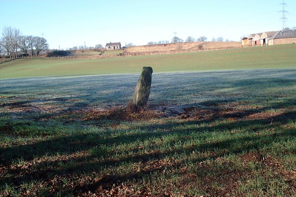
This wee stone stands near Court Hill cairn, is oriented NE-SW, and measures 1.3m high x 1.4m long x 0.5m thick. There are no markings on it, but it has quite a fantastic pattern to the stone – I have tried to capture this in one of the photographs.


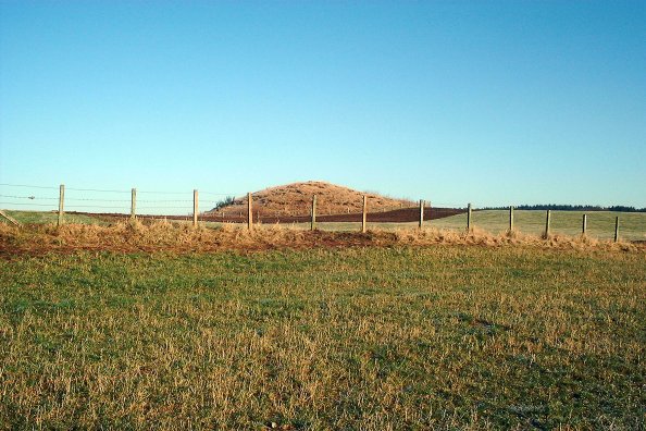


Visited this site today, as it’s adjacent to the Loak standing Stone. From Canmore: “This is a large turf-covered barrow, mainly of earth but with some stone evident, 4.0 to 5.0m high and formerly covered by trees. It is situated on relatively flat arable land and is readily visible from all directions. A slight terrace effect halfway down the east side of the tumulus is probably due to the tree-planting. Traditionally the site of judicial courts held prior to 1745.”
Hence the alternative name. There’s little else in Canmore about it, so presumably it hasn’t been excavated. The farmer did tell me, however, that this area lies on a gravel bed, and that the local estate has made some plans to quarry for this. He wasn’t sure how advanced the plans were – but possibly another cause for Heritage Action? I’ll be keeping a close eye on local developments here.
The view from the cairn is quite spectacular, and I make no apologies for posting a couple of pictures of these. The cairn seems to be the central feature in a number of low mounds running NW towards the Obney hills, which can be faintly discerned in a couple of the pictures. Anyone have any theories for this? A long line of standing stones runs from Denmarkfield Farm, through Cramflat, Gellybanks, Loak, and Pitsundry to the Witch’s Stone at Meickle Obney. Could be just serendipity, though...


I don’t know where Talorcan got his story from, but it’s not the one I know.
The King’s Stone marks the spot where a Scottish peasant farmer was ennobled following the Battle of Luncarty, c 990 AD. He and his sons assisted the Scots forces, by blocking the flight of some of the Danes using a large yoke, allowing them to be cut down by the pursuing Scots. Exhausted by his endeavours, the elderly man sat with his back to the stone, puffing and panting – “Hey, hey”. The King, impressed by his efforts, was alleged to have said “Hech hey, say ye, and Hay shall ye be”. He was gifted the lands between the Hawk Stane and the Falcon Stone for his efforts.
I spoke to the farmer here today, and that’s the story he was told by his grandfather. He even pointed to the low ridge to the north of the stone, and told me that he was told this was the hill the Scots forces charged down in pursuit of the Danes.

Looking east, the large quartz vein visible on the shoulder of the western stone


