
nickbrand
This website is dedicated to the megalithic sites of Perthshire. Just now, it focuses on standing stones, stone circles, and ring cairns, but with time it will hopefully expand to include other megalithic sites in Perthshire. Contains an impressive listing of all the standing stones, stone circles and ring cairns in Perthshire (including possible and destroyed sites).
Standing stones, stone circles and other prehistoric sites in Perthshire.
This granite slab, which is designated a Class 1 stone and measures 1.98m in height and 1.75m in width at ground level, is set upright in a modern socket-stone on the summit of a cairn. Aligned ENE-WSW, the stone has incised on it an animal, possibly a wolf, at the top, a double-disc and Z-rod in the centre, and a mirror and comb arranged vertically near the base. It is alternatively known as the Baldowie Stone.
Aberdeenshire recumbent stone circles, Pictish stones, legends, images.
From the Stones Mailing List, another interesting revelation – posted to the list by Sigurd Towie, whose excellent site Heritage of Orkney should not be missed.
Another extract from my forthcoming archeological review of 2002 that may be of interest:
“The designation of the area surrounding Maeshowe, Brodgar, the Standing Stones and Skara Brae as a UNESCO World Heritage Site in 1999 has resulted in a number of projects to better understand the archaeology – visible and invisible – within the landscape. One of these was an extensive geophysics survey of the Brodgar peninsula – the thin neck of land bordered by the Harray and Stenness lochs.
Among the many features revealed by the five month operation is the existence of a fourth ‘object’ in the ground by the Comet Stone – the megalith that lies about 150 yards from the Ring of Brodgar – as well as a number of features within the Brodgar ring itself.”
The full report will appear on my site shortly.
--
Sigurd Towrie
From the Stones Mailing List, some interesting discoveries – posted to the list by Sigurd Towie, whose excellent site is mentioned elsewhere here.
I was going to hold onto this until my complete article appeared in The Orcadian, but following a number of e-mails received today after a story on Radio Orkney this morning, here’s the relevant extract:
“While attention over recent years has been firmly on Tankerness and the underground chamber of Minehowe, the emphasis in 2002 shifted firmly back to the West Mainland and the “Neolithic Heart of Orkney”.
There, for the first time in almost 30 years, the area around two of Orkney’s best-known ancient monuments – the Ring of Brodgar and Standing Stones of Stenness – came under close scrutiny.
Not only was a large section of the Ness of Brodgar painstakingly scanned, but a chance discovery of two large stones on the shore of the Stenness loch could shed some light on the construction of the stone circles, in particular how the megaliths were transported from the quarry site.
While walking the eastern shore of the Stenness Loch, Nick Card of Orkney Archaeological Trust (OAT) came across the two prone stones lying by the water. The stones, just to the north of the Wasbister disc barrow, could indicate that after being hauled to the loch after quarrying, the megaliths took to the water for their final leg of the journey. Although Nick is only certain that one of the stones was destined to be a standing stone, the discovery has intriguing parallels with a local tradition that other stones lie within the loch itself.
“It could be that these stones may once have been erected but were knocked or fell down in more recent history,” suggested Nick, “but this seems unlikely. If they had been standing, they would surely have been recorded somewhere. It seems more probable that they were actually on the way somewhere. And if you were moving something that size it makes sense to use the water.”
Staying on the subject of standing stones, work at Vestrafiold in Sandwick over the summer seems to have confirmed that megaliths were indeed quarried there – the location long held to be the source of the Stenness stones. The project, led by Dr Colin Richards of Manchester University, hopes to reveal more about the people who hewed the great stones from the quarry and moved them more than seven miles to the Ness of Brodgar. Previous investigative has concentrated on the stone circles themselves, but Dr Richards’ project could provide an intriguing glimpse behind the scenes of the construction of Orkney’s grandest prehistoric relics. The Vestrafiold work is ongoing and Dr Richards hopes to return in 2003.”
Not much else can be said about the Vestrafiold project at present – landowner isn’t keen on publicity.
--
Sigurd Towrie
Blackhall – Kirbister – Stromness – Orkney
Heritage of Orkney: https://www.orkneyjar.com


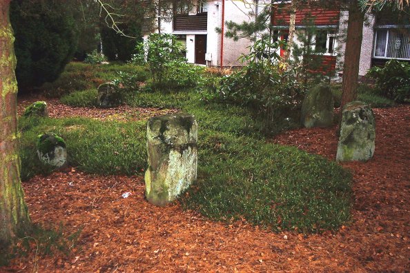


Originally this circle stood in New Scone until excavated in 1961 prior to the housing development it is now in the midst of. Seven stones, diameter of the circle about 16-17 feet, graded with the largest stones on the W-SW arc. An urn containing a token cremation was found in the centre during excavation.


I was out that way today. It’s pretty easy to find. If you’re heading east along the road, keep going till you see a metal barrier on the south side of the road – barring access to the wood. Cross to the north side, head east about 30m and it will be just at your feet!


The stone looking north (Lendrick Lodge in the distance)

Leave the A928 just before Kirriemuir and take the un-numbered road leading west. About a mile and a half along this you will see Lendrick Lodge on your right (north of the road). If you park here carefully, then there’s a gate into the field south of the road, where the stone lies.
The lady who lives in the Lodge is very informative. She told me a bit about the stone. Apparently a good few years ago the farmer at Linross was one of these ‘progressive’ types. The stone was removed and dumped in a corner of the field. A short while later, a man with a clipboard turns up at her door, asking ‘didn’t there used to be a stone in that field’, so she told him the story. Two weeks later the stone was back in its original position.... One up for the man with the clipboard!


This one lies just of the A926, a busy little road and it can be awkward parking nearby. The stone’s about 5-1/2 feet tall, and flares out a bit near the top – rather like the Bonhard stone, I think. A bit of field clearance built up round it, and a few scrape marks from farm machinery. No significant markings, though.


View of the circle remains from half way up the hill to the outlier


The outlier has some cup marks on it, low down on the SE edge. They appear to form a rough diamond shape, visible in a couple of the pictures I have posted.


Park at the foot of the hill – just off the Ninewells access roundabout, on the south side, is a small residential area where there is usually parking space. Walk up the drive towards the hospital, and as you pass the first curve you’ll see the cairn on your right.
This cairn or barrow is described thus in Canmore: “A small circular, wooded enclosure on Menzieshill farm, known locally as “Dark Stane” Roundie, derived its name from a large upright block of dark whinstone, standing near its centre, almost enveloped in foliage. It has been suggested that it formed part of a stone circle, and when it was removed in 1888, a quantity of bones was ploughed up at the spot where it stood. Further human bones were found all over the Roundie when it was ploughed over. The stone was about 7’ high, 4’ broad and 1’ thick, entirely unsculptured, but fairly smooth on the sides which faced east and west. A large piece lying on the ground was said to have been struck off by lightning.”
The stone has long since gone, as has the wood. On the top of the cairn now are a few small stones, which look like Victorian railing supports – only 4 of a possible 7 or 8 are left, all with small holes facing outward. There’s not much left to look at, and it is now almost surrounded by roads and housing developments.


Leave the A90 Dundee to Perth dual carriageway at the Errol turn off and head towards Rait. As you approach a small crossroads you will see the Rati Farm steadings just up ahead on the right (nowadays an Antiques Centre with several shops). Turn right into the steadings then right again into the car park – the stone is at the corner as you turn in.
This is a very interesting stone, absolutely covered in cup marks on the upper surface. According to Canmore, “the boulder measures 1.5m by 1.2m and is at least 0.4m in thickness, and the cups measures up to 80mm in diameter. The arrangement of the cups includes a large one which is surrounded by six equally-spaced smaller cups; this pattern of cup-marks is similar to the rosettes which occur at Ormaig in Argyll but with the outer ringmark missing. Given that the boulder was placed in its present position fairly recently after having lain nearby for some time, it is likely that it was originally found in the field which lies S and E of the steading as it bears plough scarring and was almost certainly buried before discovery.” There are certainly distinct plough marks on it. It is a short walk from here to the Fingask standing stone also well worth a visit.

