ocifant

ocifant

All posts 451-500 of 505 posts

Knollbury Camp

An interesting site, if only for the lack of features. What we have here is a square embanked enclosure, approx 200 yards on a side, with (entrance?) gaps at the corners on the eastern side. I didn’t enter the site itself – there are no information signs and the gates to adjoining fields were locked – although the wall is easily surmountable as a section is being repaired completely out of keeping by the application of a slab of flat concrete on top rather than drystone.

The enclosure commands excellent cross-country views to the south and east, but the ground rises to the north obstructing the view in that direction.

Gun Rith to be re-erected next month?

According to a post from Andy Norfolk on the Stones Mailing List, Gun Rith is to be re-erected sometime at the end of May.

Good News.

The Rollright Stones

Passed by this way yesterday, totally unplanned so no camera etc.

I was struck by how different the site looked with the undergrowth at it’s lowest point. Last time I was here, the trees and hedges were in full bloom, and the stones couldn’t be seen from the road at all. Yesterday, the circle could be seen ‘properly’ in its setting. A much more pleasurable experience.

The Cove

Sorry, but despite their size these seemed to me to be just an ‘attraction’ for the pub. No life, or sense of ‘place’ at all…

The Great Circle, North East Circle & Avenues

Such a large site, it’s difficult to get a proper perspective – at least at Avebury you can climb a bank and see much of the circle laid out in front of you.

What I got here was a feeling of a large circle for ‘proper’ ritual, accompanied by a ‘training’ circle for the neophytes. No idea if this is how it was actually used, just a strong feeling I got.

It seemed to me too that the stones were made of the same rock as at the Rollrights – all eaten away and crumbly.

Chûn Quoit

I approached from Trehyllys Farm – follow the signs to Great Bosullow and Chun Castle from Bosullow Common (the Lanyon road). Were it not for the GPS, I’d have taken a wrong turn at the farm – turn right at the farm buildings then head for the top left corner of the field for the shortest route to the top via a very narrow track bordered by chest high gorse. I wouldn’t want to tackle this route in high summer!

Having reached the castle at the summit, the view was well worth the climb. I entered the castle via the gateway, and turning round, caught my first view of the quoit.
I don’t think I’ve ever fallen so completely in love with a site as I did with the quoit. It’s totally delightful, but try as I might, I couldn’t squeeze through the entrance to sit inside. The old guys were obviously much slimmer than me. Looking around, it’s difficult to imagine how harsh life must have been back then, as the site is so isolated. I couldn’t help wondering what else is waiting to be discovered under all the gorse and bracken up on the hill. I’ll definitely be back here soon.

Back at the castle, I found the cup-marked stones and what looked like a carved stone chair. I’m not certain I’d want to drink from the well though…

Trippet Stones

Yay! I get to write the first notes for this site! Coming from the East, the stones are easy to find. Having passed the Jamaica Inn, continue west on the A30 to the end of the dual carriageway. Opposite a left hand turn to Temple, turn right (signposted St Brewards). Pass over the cattle grid and continue along the single-track road for about half a mile. At the crossroads (signposted Treswigga), turn right onto a farm track. The stones are on the left about a quarter of a mile along.

The earlier rain having stopped, the wind was blowing a gale, and the telephone wires which run close to the stones were really singing, giving an eerie feel to the site. Each of the stones was in its own small pool of water, like so many islands, having obviously been used as rubbing stones by the local ponies.

The circle consists of 7 uprights with a few recumbent/fallen stones, and a small centre stone. A cist lies just outside the circle to the southwest.

Gûn Rith Menhir

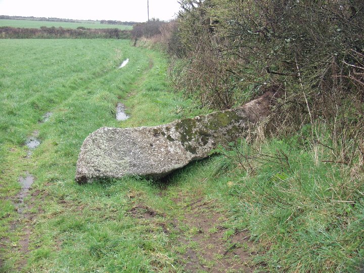
Bad news I’m afraid. This ‘sexy stone’ is no more. I passed here today (I’ll post a fuller weblog on my return home next week), and the Gun Rith menhir is down.

I wondered why I couldn’t see it from the Merry Maidens, and it was only when I went into the field that I realised the stone was down. It’s fallen across the cart tracks into the adjoining field, so no doubt the farmer will be moving it soon. I’ve tried to get a message to Andy Norfolk in the hope that the restoration can be done sensitively.

I’ve taken a few photos of the fallen stone, but can’t upload them on this connection. More to follow next week.... ...Pictures now uploaded, and the stone hadn’t yet been moved when I paid a return visit a couple of days later.

Waulud’s Bank

The book states that this is in the middle of a housing estate, and so it proved to be. There were a couple of burnt out motor vehicles and so much urban rubbish that archeaologists of the future will truly have a ‘field day’ here...

The source of the Lea is trapped in a concrete and steelwork cage, as mentioned by Julian. It’s very difficult to make out the layout of the bank itself from the lea-side. The course of the bank is more obvious from the road, but looks just like the soundproofing embankments so loved of modern planners. The only difference between the bank and its modern equivalent is that there are no houses behind it.

The Five Knolls

Wind. Lots of it. The Downs in February are cold. The gliders were out in force, swooping overhead like circling hawks. The wind was biting, taking my breath away, yet standing among the barrows, all seemed quiet.

Magnificent views to the north, and to the west is a slightly higher ridge. If the landscape were unchanged, I can’t help feeling that the higher ridge would have provided a better site/sight for the barrows, being in view of Ivinghoe Beacon across the valley.

Despite the signs exhorting no damage, the barrows all look as though bikers have been using them for jumps, each barrow having a track right across its top.

Kit’s Coty

Regarding Kammer’s comments re parking, I’d suggest following the sign to the Kit’s Coty Brasserie (drop down off the A229, past the pub then immediate right (back to the A229) then immediate right again). Small car park on the crest. Walk the rest of the road, then cross the road at the junction and follow the steps down straight to Kit’s Coty. No good for the Countless Stones though, unless you enjoy a walk.

This was a repeat visit after my New Year’s Day trip which resulted in corrupted photos (see my entry for the Chestnuts. I think I must be fated as, having checked 3 sets of batteries the previous night, 2 sets were dead when I got there! Changing camera batteries in the rain is not a pleasant experience...

Anyway, the stones seemed very sad, sitting alone on the edge of the field, caged as they are. There was a lot more site damage compared to my visit on the 1st. Lots of chalked graffitti – childishly scrawled pentagrams probably reflecting the mental age of the idiots who do this kind of thing. Some flowers (memorial wreaths) had been left outside the railings – easily moved, but they seemed very fresh so I left them as they were. The worst damage was at the ‘back’, against one of the uprights where it looked as if someone had tried to dig a small pit against the base of the stone.

I suppose, trying to be reasonable, this damage is minor compared to the 19c names and dates carved into the stones, and to the much more major damage of having had the full burial mound removed which left the uncovered stones as they can be seen today. For all that, I wish these idiots would just leave them as they are, to be enjoyed.

London Stone

Have to agree with the other comments here. A very undignified way for the Stone to be treated. People in the lunchtime rush looked at me as if I were mad, taking photos of a wall of a bank! I’m sure none of them had ever looked to see what was there...

The Stone seemed to be screaming to be let free. Given the planning permission mentioned in the News Article last year, it looks as if its wish may be granted, but I couldn’t see any signs or notices in place, so maybe they’ve put the plans back. Does anyone have a better notion of timing for the demolition?

I’ll have to make sure I get down here a bit more regularly in the lunch hour, now I know exactly where it is, to make sure the Stone isn’t forgotten and doesn’t get lonely, trapped in its cage.