SE10617, 46591
This medium sized toblerone chunk of rock is low to the ground and partly overgrown but as Stubob says it is fairly easy to spot if you know where you’re looking. It is quite badly worn but about a dozen cups are still clearly visible, four of them have rings, two of these having grooves running from the rings.
If you haven’t visited this part of the Moor before, don’t be fooled by the map into thinking that Keighley road is in fact a road. At the turn for Silver Well Cottage it is blocked for traffic and any anyway it soon deteriorates into a gravel track suitable only for four wheel drive vehicles. No doubt Sir Mortimer Wheeler would have given it short shrift though!

Chris Collyer

A minature Uluru. The colour of the stone changed from a deep bronze to a dull brown as the sun set in the West.

Detail of the incomplete swastika – perhaps it was never meant to be complete.

I don’t know much about art, but I know what I like....
Well, 1 week and 2 hours after my first visit I was back again at the Badger Stone, it the same sunny spring weather but those couple of hours made a world of difference. What before was a grey featureless stone had been transformed by the sun sinking slowly in the West into a miniature Uluru/Ayers Rock, a beautiful golden brown mound with the carvings now throw into sharp relief by the near horizontal early evening sunlight. As I had rushed over the moor from Weary Hill I had worried that the sun was getting too low and I would miss the carvings for a second time – I needn’t have worried, the south-west face of the Badger Stone was lit up like a static firework display – cups, rings, gutters, strange grooves and the incomplete swastika were all clearly visible.
As I was making my way over from Weary Hill, a short distance from it I was checking the map to make sure I was heading in the right directing when I looked up and realised the Badger Stone was clearly visible on the horizon half a mile away, although it dipped in and out of view and was out of sight from as little as 100 metres away. It started me wondering about the intervisibility between the various carved stones on the moor – from the Badger stone I could see Willy Hall’s Wood and the positions of the Neb Stone and Weary Hill. Which other stones could be seen and if there might be any significance in these sightlines is something I’ll have to look into next time, it may help to explain why some non-descript stones seem to be profusely carved while others that would seem to be prime candidates for decoration have no carvings at all.

Baal in Baildon – an article from a book called
“Through Airedale From Goole To Malham” written in 1891


SE13706,39619
To find this stone take the track that leads south from Dobrudden Farm towards a wall in the distance. When you reach it walk down its right hand side and past an entrance. From here head out diagonally, the stone is fairly visible, but when I was there about a quarter of it was covered with invading undergrowth.
The triangular stone is covered with a complex series of cups (about 50), rings and grooves. One of the most striking things about the stone is the views – down past Shipley Glen and over to Bingley and Saltaire
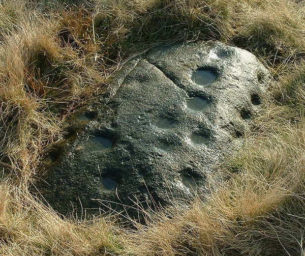
SE13736,40227 I had difficulty finding this stone even though it is close to a track and a bell pit, as it is fairly small and lower than the surrounding grass. It has around a dozen cups on its top surface, and also has a line of cups along it’s edge

It took me a while to find this one, which lays at SE13768,39899 near a bell pit south-east of the park and fairly close to a track. It has around 25 cups scattered over it with carvings on the west and north side. The first consists of 3 linked cups with an oval groove running around them – it reminded me of ET’s face! The second is a complex and confusing pattern that includes 6 cups, some with rings, some joined, and with a deep groove around it. There is also a deep groove on the southern side of the stone.

This stone is propped up against the north wall of Dubrudden Farm Caravan Park.
This stone is easy to find as it is propped up against the north wall of Dobrudden Farm at SE13720,40098 although exactly where it originally lay is uncertain. The top part of the stone has 8 cups, 2 of which have rings which intersect each other. The bottom half has about 16 cups, the top 3 are in a row with intersecting rings around them. 4 cups on the left have a groove running round them, and there seems to be a groove that continues around the bottom and up the right hand side of the stone. Three sets of cups are also linked.
A couple of metres to the northeast of a small flat stone which has 2 cup and rings and a pair of groves which could be natural.


Stone at SE13645,39803. It has a cup with a possible wide ring, although the left hand side looks natural.

Baildon Moor is Ilkley Moor’s little sister, a few miles to the south it is both smaller and flatter which certainly makes it easier on the legs. For some reason it seems particularly popular with weekenders out for a stroll and folk walking dogs, but there are around 40 or so marked rocks here, with two third of them north/north-east of Dobrudden Farm caravan park although two of the best examples are to the east and the south of the park.
There are also said to be the remains at least 2 stone circles – one at Windy Hill and one north of the road at Pennythorne Hill but don’t expect to see much, if anything. There are also several badly damaged cairns, a destroyed Bronze Age field system, and quite a few recent bell pits.
Parking is easy at a free carpark north of Bingley Road where there are the remains of ‘Coll’s Burial Mound’ ring cairn, from here walk a short distance west to a track that leads uphill and south to Dobrudden Farm. Many of the stones lie close to this track. In Dyers ‘Discovering Prehistoric England’ he mentions 4 prominent stones and I’ve added these as separate sites and used his numbering system as an aid for those who have the book.


Cup with ring, 2 grooves and ladder formation to the right
The Barmishaw stone has some of Ilkley’s speciality carvings, the so called ‘ladders’. The patterns on the stone can be difficult to make out but there are said to be 6 of these ladder forms, as well as 24 cups, 9 of which have rings.
To find the stone, walk north from the Badger Stone, continue past the east-west track and continue roughly in the direction of the woods for 2 or 3 minutes. Although it is flat and only very low, the stone is a reasonable size and can be seen to the right in a clearing in the undergrowth.
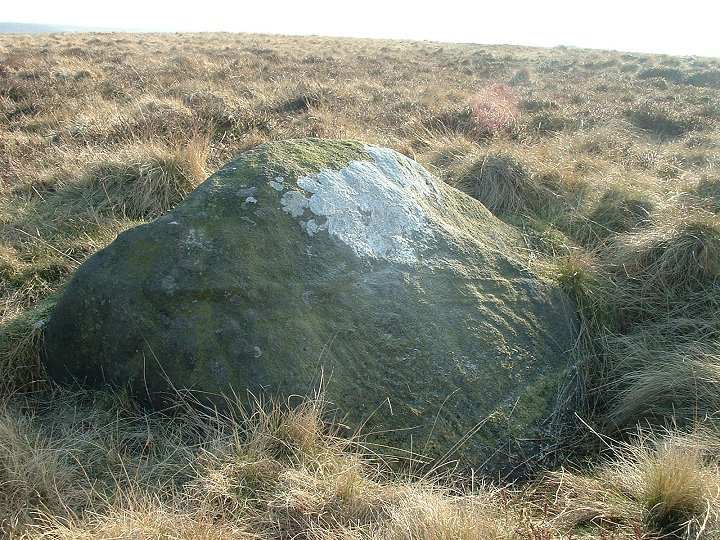
Like Ironman, I have to admit that I was a little disappointed by the Badger stone, this being my first visit. It was smaller than I had pictured it and due to the position of the sun the famous carvings were very difficult to make out and even more difficult to photograph. I thought the wooden bench next to it detracted from it as well – somehow it forces the modern world on the site – in the hour I was there, apart from a knowledgeable local I met, only 2 people came past on the track.
Definitely a stone to come back to when a more favourable light can do it justice.

View of the southern end of Willy Hall’s Wood with the stone in the centre of the picture.

This site is fairly straightforward to get to, although not necessarily easy. There is plenty of parking space at White Wells carpark – walk to the old pump house and then head due south uphill keeping the white building of the old bathhouse to your left and head towards the waterfall. Once you get there is a very steep climb up beside the small falls (there may well be easier routes round the side) that leads to the outcrop of land the forms the north end of Willy Hall’s Wood. This is the place that Gyrus mentions on the main Rombald’s Moor page – it is indeed a wonderful place and has an air of ‘sacred grove’ about it. Continue south through the trees and just before they end you will find the large tilted stone with carvings across its southern face, these consist of about 17 cups, some of which have rings and some with interconnecting grooves. Just beyond the carved rock is another boulder that has three large saucer shaped indentations – I thought they may have been man-made but found out later from a knowledgeable local that he believed they were natural.
When I looked at my photo’s, the sunlight had caused the carvings to be almost invisible, but I noticed that the trees, stone and landscape seemed to be at chaotic angles – it wasn’t just my poor photography, this place is really like that.


It is easy to see how this rock got it’s name. A medium size stone with the top part covered in cups – nearly 50 of them, that does indeed resemble a pepperpot. On a lower part of the rock there are a further 17 cups.
I can’t give exact directions as I had cut across the hillside from Willy Hall’s Wood, but it is about 20 paces to the right of a well used track that leads uphill southeast from close to White Wells towards a small wood. There is another stone on the other side of the track that has about half a dozen faint cups.
Dr Aaron Watson’s introduction to his research on the acoustic effects produced at stone circles and passage graves.


It’s obvious from the picture why Stukeley thought this was a row of round barrows.
There is very little to see on this site now, but Dyer includes it in Discovering Prehistoric England, Ann Woodward covers it in her book, and Julian flags it as standing next to a presumed Neolithic trackway in his Gypsey Race map, so I’ll include it as well although it is probably for anoraks only.
If you stand at the bend in the road with the field boundary in front of you the long barrow is hard to make out in the field to the right and there are the low remains of a bowl barrow between it and the road which confuses things. To the left of the boundary there are a couple of low round barrows recorded by Canon Greenwell but unexcavated.
The long barrow is around 50 metres long and 13 metres wide oriented east-west and badly ploughed down. The north and south flanking ditches are completely filled. The barrow has been excavated twice – by Greenwell in 1865 and Manby in 1958 and between them they found 3 burials, a collection of bones and remains of cremations, sherds from pots and flint fragments. The mortuary structure was trapezoidal with a concave wooden palisade at the east end, the whole thing being covered with an earth and chalk mound before being fired – creating a crematoria with temperatures estimated to have reached nearly 1200 centigrade. Radiocarbon tests from the site suggest a date of around 3000BC.
Info-
English Heritage
Ann Woodward – British Barrows
Dyer – Discovering Prehistoric England

This is the huge barrow that can be seen just to the north of Maiden Castle and is one of the largest mounds in Dorset. It was part of a group of round barrows that seem to be related to an early long barrow that has since be ploughed out. It has only ever been partly excavated – a secondary burial of the Romano-Celtic era was discovered in 1862.
Ann Woodward in her book British Barrows (pages 139-143) goes into great detail about viewsheds from the top of the barrow and suggests that it was enlarged and heightened over time specifically for this purpose. Her evidence is certainly convincing, from the base of the barrow the views are limited, from the top there are sightlines to several long barrows as well as extensive views to the north and east from the North Dorset Ridge to Purbeck.
Info –
Ann Woodward – British Barrows, A Matter of Life and Death ISBN 0-7524-1468-2
English Heritage, Record of Scheduled Monuments
Northwest of Maiden Castle, this barrow was excavated by Cunnington in 1882. It is important for the finds from the site which included fragments of an incense cup, a broken dagger, a macehead made of shale which originally had 5 inlaid gold bosses and a patterned gold lozenge similar to the one found in the Bush Barrow near Stonehenge.
Website dealing with Bronze Age metalworking. Check out the shop section for some amazing reproduction axes, swords and daggers.
Nice guide to some of the megalithic sites of Britain and Ireland by a chap called Richard M.
Sharp(e) Howe itself is a nice barrow in a reasonably well preserved state despite its flanking of trees. When I visited in September 2002 there was a large piece of agricultural equipment left next to it, in Feb 2003 it had become the storage place for bails of straw – it seems to me the barrow is lucky to have survived at all. Canon Greenwell writing in 1890 says that the barrow originally had a ‘conical form’, the top 6 feet having been removed ‘many years ago, but within living memory’.
I’m not sure about the state of the other mounds in this group although one at TA 051770 is still stands around a foot tall.


View of Sharp(e) Howe from the track that leads to Folkton Barrow/Kirkheads. Feb 2003
Further to what Fitz says there were in fact 8 barrows in this group that were excavated by Canon Greenwell – there were 2 to the south and one to the northeast of the close group of 5 barrows.
The barrow that Fitz mentions was called Sharp Howe by Greenwell but is now marked on the OS map as ‘Sharpe Howe’.
Julian is right when he says there is nothing left to be seen of the Folkton barrow – it was only just over 2 feet tall when Canon Greenwell excavated it in the 1880’s. He is also right when he says the site is worth a visit though, not just because of the chalk drums but for the position of the barrow. As you follow the public right of way from the roadside eastwards, the landscape opens out in front of you as a huge natural crossroads between the hills. The barrow would have overlooked what could have been an important junction of 2 trading routes and it left me speculating on the possibility that there could have been some kind of stone marker at the bottom of the valley, although there is no record of one ever standing here.
A word of warning – a sign on a gate warns of a bull in the field – luckily he wasn’t there on the day I visited.
In TMA there is a photo of the three chalk drums recovered from the barrow but no indication of scale. Buried with the body of a child their heights are only 11.8cm, 10.5cm, 8.6cm and their diameters are 14.6cm, 12.7cm, 10.2cm respectively. Although the tops of the drums appear to form lids, they are in fact solid and not hollow. The apparent markings of eyes, eyebrows and noses have lead some to think that they may be idol figures of some kind, others believe they could be copies of incense cups.
Info –
Canon Greenwell’s excavation report 1890
Dyer – Discovering Prehistoric England
Note, Dyers map reference is wrong. It should be TA not SE.

