
This site consists of a pair of bowl barrows that stand at the edge of a farmers field on the other side of the road from a row of expensive houses in this tiny Lincolnshire village. At the beginning of the 20th century they were recorded as part of a small four barrow cemetery which was later partially excavated in the 1930’s when a small amount of Middle Bronze Age pottery fragments were found – since then the other two barrows have been lost either to the plough or the modern houses. Further finds suggest that the mounds were reused from the medieval period onwards as archery butts, beacon fires or village meeting places and their continued use is reflected in the barrows names – the west barrow is known as Folk Moot, the eastern as Butt Mound. I rather like this continuity of use although I can’t imagine they are much used nowadays as both are overgrown with grasses and a rather lethal patch of nettles. Folk Moot is the larger of the two, and stands around 2 metres tall and nearly 20 metres across at it’s widest point (the northern side has been ploughed away) while Butt Mound is about a metre high and 10-12 metres wide – it too has been plough damaged on the northern side.
Folk Moot is at TF054430. Butt Mound is at TF055430.

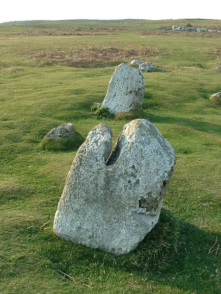
Little John in the foreground, Robin Hood just beyond it (according to the OS Map), looking somewhere in the direction of the Roman camp.
I have to say I’m with Kammer on this one.
The stones just don’t look old enough and they are *very* square. Having said that, Burl must have looked at more stones than just about any living person and I’m presuming he has visited the site so what’s going on here?
Looking at their alignment they seem to be pointing roughly in the direction of the Roman town/camp of Durobrivae which I’m sure would have been visible from here – are they Roman? The stones are also scheduled monuments although I can’t find any information about their scheduling.
I found it fairly easy to get to the slip road that the stones stand next to but I was lucky in that it was a late Sunday afternoon and the roads were very quiet – I parked too far up the road though and after scrambling through the bushes walked in the wrong direction. One thing I did notice was the large amount of litter along the edge of the field, mainly empty beer bottles, cans and tubes of glue – obviously a popular place with the local yoof. The piles of broken windscreen glass in the carpark didn’t fill me with confidence either...

The circlular (?) wall of the churchyard is to the right of the picture.

Is the bottom of the larger rock (in sunlight) where the smaller stone was broken off?
I thought these two stones might be hidden away behind the church, overgrown and forgotten, but no. The glacial erratics stand outside the main entrance to the churchyard with the grass neatly trimmed from around them and I got the impression that the inhabitants of the pretty village of Anwick are rather proud of them. The larger stone (nearest the church) is about a metre high while the smaller stone is about half that – it’s hard to tell whether they were part of the same rock as the folk tale suggests or not, although the larger stone looks like it could have had a large chunk knocked off of it near ground level. It’s also difficult to know whether this was their original position, but why move the stones to stand outside a churchyard?
Interestingly the churchyard appears to be roughly circular (I didn’t have time to fully check it out) and it is said that before the original stone was moved and broken (if it was ever moved) that a Dr Oliver ‘attested that it was of druidic origin’
A local curiosity, or the subject of pagan idolatry – who knows…
Lovely little village though.


List of the scheduled monuments around Bradford including most of the sites on Rombald’s Moor
This has to be one of my favourite carvings on the moor despite the fact that it is close to a fair bit of passing human traffic and noise and has been the subject of vandalism in the form quarrying, as well as peoples names and even modern celtic patterns chipped out of the rock. The motifs though amaze me – I think this is only the second time I’ve visited, the first time I managed to completely miss a large section of the carvings and there may be more here that I haven’t yet recognised. The largest motif consists of a deep central cup with double joined arcs and extending grooves, one of which has a peculiar kink in it as it curves away to the west before turning sharply to the north. Just to the east of the pattern a deep groove runs northwest-southeast. On either side of it are about half a dozen cups, 3 rings and several unfinished rings or grooves. To the west is the second motif that seems to have been damaged by quarrying, again it has an almost central cup, this time with a ring that a doesn’t quite meet and a pair of grooves extending from either side that curve in and also do not quite meet. Through the middle of these 2 elements is a half circle groove which also has an uncut centre – why were these 3 elements left with uncut centres? Between the 2 main motifs, 5 cups and a small groove form a triangle – Stan Beckensall shows a further motif to the south but I couldn’t find it.
In my last fieldnote for this site I mentioned that normal maps are of no use on the moor and the GPS reigns supreme. At the time and with the maps I had this was largely true although the comment now seems rather ignorant and cringeworthy. Yes, a GPS will take you close to the stones but it is no replacement for a decent map – I would definitely recommend a visit to magic.gov.uk to get some printouts at 1:5000 or 1:10000 which accurately show the many tracks over the moor as well as the locations of most of the stones and other scheduled monuments.

I finally re-found this stone although I still don’t know if it has a name – for convenience I’ve decided to call it the Goth Stone (don’t ask!). It is at SE12734625 and stands on the same track that leads southwest across the moor north of Backstone Beck and passes Backstone Circle. It measures 120x110cm and has around 45 cups, a ring and several deep grooves. One of these grooves runs along the line of a natural fault in the stone.
These is another carved stone just to the northwest (I’ve called it the Second Goth Stone)

Second Goth Stone. SE12724628 180x120cm
This stone is to the northwest of the ‘Goth Stone’ (a made up name) and took some finding even though it is not that far from a rarely used track. As the light was getting poor with very little shadow it was difficult to accurately make out all of the designs carved onto its surface but I counted over 30 cups, 3 rings, 6 or more penannulars or unfinished/eroded rings and a couple of possible grooves – although these grooves could be natural.

I’m still not convinced about this site, but I thought I’d give it another look. Just to the northwest of a track that runs along the west of Backstone Beck and jumbled in amongst drystone walling I counted 9 upright slender slabs that looked more like the kind of thing you buy from a garden centre to create a stone circle in your garden. Having just got hold of a copy of Paul Bennett’s “Circles, Standing Stones and Legendary Rocks of West Yorkshire” he seems pretty sure that it is in fact a double circle with embankment but points out that the overgrown nature of the site and the walling make an accurate determination of it difficult – well I won’t argue with that! He also mentions the isosceles triangle formed by Backstone, The Twelve Apostles and The Grubstones as well as proposing an alignment between The Swastika Stone, Backstone and the Idol Stone (which I haven’t had chance to check out yet), the remains of a possible stone maze and a fallen monolith – I’ll be having a root around for those next time.

Stone 3 – the Second Idol Stone. SE12834615


Stone 1 at SE12824619. The path is at the top right of the picture.

Part of the enclosure wall to the west.
If you follow the track that leads west from the Haystack rock and then swing round to the south you pass the partly reconstructed Backstone Beck Enclosure. Between the arc of drystone walling and the path, and northwest of the hut are 3 carved rocks nestling in the heather and almost in a northwest line.. The last time I was here I completely failed to find them, even though I must have walked within a couple of feet of one of them – this time as I approached from the south and had a better idea where they were I had more luck. Stone 1 is at SE12824619 and measures 180x130cm with around 45 cups, a couple of unfinished rings or arcs and several grooves – it lies just to the east of the path. Stone 2 is a little further southeast at SE12844617, it has about a dozen cups, 2 of which are quite deep, and measures 170x130cm. Stone 3 is the one I really wanted to find and when I located it a little further south at SE12834615 I couldn’t help letting out a Marc Riley stylee “Oh Yeessshh”. The stone is known as the Second Idol Stone and it’s easy to see why – a 130x80cm low stone with 24 cups and 5 deep grooves. Nine of the cups are zoned within a groove at the northeastern end and a further 6 run in a line between the edge of that groove and another that runs nearly the entire length of the stone. This rock is very similar to the Idol Stone 500 metres to the southeast – I wonder if they were carved by the same person?


You can’t miss this large rock as it stands next to a main track and is 5.5 metres long, 3 metres wide and stands nearly 2 meters tall. It can also be seen from some distance from many points around the area and is useful as a navigation aid on the northeastern part of the moor. I had visited this rock before and noticed a few cups and a worn ring but other than that had not given it much consideration, this time I gave it a closer look as I had read that it had many more cups and it turned out to be a revelation. I counted at least 60 cups and there could well be more as the southern face is heavily eroded and it is difficult to tell what’s man made and what’s natural. Some of the cups form a line along the ridge that separates the north and south faces and there are 5 rings along the top and I counted a further 4 on the north face. There is also a cup with a gutter and penanular that has been carved along a natural crack almost giving it the appearance of a human form or an ankh as well as a line of deep cups that follow a fold in the rock and whose purpose must surely be just decorative?
Just to the west is a small rock with 3 cups on a vertical surface that faces the Haystack.
I thought this stone got its name from the fact that it looks a bit like a nose (as in ‘keep yer neb out’ = stop being nosey). Apparently it is a Yorkshire term meaning ‘to kiss’, Paul Bennett say in ‘Circles, Standing Stones and legendary rocks of West Yorkshire’ that lovers used to meet to hold their trysts here.
SE12964639 I was a bit disappointed with this stone – with such an evocative name as The Planets and with a dozen cups and 9 rings as well as linking grooves it promised to be interesting rock. In reality, in turned out to be badly worn with the rings and grooves shallow and difficult to make out, although it didn’t help that it was a dull day. It measures about 180x160cm and stands on a small outcrop of rock north of the track that leads past the Haystack rock and just before the land drops away towards the Cow and Calf rocks and carpark 500 metres to the northeast. There are also a few rocks close by that have possible cups – they could just be natural though.
Some old photographs of the village and the stones.
Ye Olde photographs of Stonehenge dating back as far as the 1880’s including some nice leaning trilithon upright shots.
The largest prehistoric man-made cavern in the world may be hidden under a north Wales peninsula.
The cavern is part of a Bronze Age copper mine complex which was first uncovered in 1987 at Great Orme’s Head near Llandudno.
Archaeologists excavating the 4,000-year-old site made their latest discovery 130ft below ground in December and have estimated it is at least 50ft in length.
They know the roof area is large, but will have to dig down through many layers of silt before they discover exactly how deep it is.
Full story at -
I visited this circle after Sunkenkirk so unfortunately it could only be an anticlimax for me and it didn’t help that it was late teatime and a cold wind was starting to get up. The outer stones are all fallen and scattered and the central setting just seems too perfect, as somebody else notes it almost feels like a fake and the steady stream of visitors somehow add to that feeling – you don’t get the sense of isolation you get at other sites. You do see some funny things at some stone circles though – while I was here a couple of blokes pulled up in a car, got out, and started putting on fencing gear including the masks. I though I was going to get to see some fancy sword-play in the circle but instead they changed back, got in the car and drove off again. Odd.


What an amazing place Sunkenkirk is, and the walk up to it just adds to the sense of pilgrimage to the site. I had stopped close to Cragg Hall and contemplated driving over the rough track to the circle but I spoke to a couple of families with small kids who were walking past to ask their advice. Luckily for me they knew the area well and as they were walking up to the circle themselves to take the children on an Easter Egg hunt they let me tag along, which was nice as the track is unfenced for the most part and wild untamed beasts are allowed to roam freely (ok, so they were placid cows who completely ignored us, but they were bigger than me and had more legs. To misquote Orwell – ‘two legs good, four legs faster’). The stones can be seen from a fair distance but it’s not until you get up to the gate that leads into their field that you really appreciate the circle, Burl calls it one of the finest stone circles in western Europe and of all the circles I’ve seen, I’m not going to argue with that. He also claims 55 stones remaining but I was so caught up with wandering round them that I forgot to count and to be honest I don’t think it really matters. The location, the layout, the size, the views and the walk up to the circle are everything – this was my first visit, I just know it will be the first of many. Absolutely fantastic.

A different view of the stones. Are the sloping tops pointing upwards to the sky, or down to the ground?

These stone baffle me. Yes, they stand in the foreground of Black Combe which conjures up such terms as ‘ominous’ and ‘looming’, but I’m not sure they have anything to do with it. That mass of rock lurks to the north and the smaller hill that contain the Lacra circles is just to the east, and at first I thought the two stones may be pointing in that direction but now I’m not sure of that either. A report from the late 18th century suggests that they originally stood as part of a burial mound which has now gone but if they are in their original position and orientation then the axis of alignment is roughly southwest-northeast, either pointing out to sea or in the direction of the valley of Whitcham Beck – were they indicating a safe route between the hills or were they just grave markers? If the direction of the narrow edges of the stones is taken into consideration, then its northwest-southeast marking the lowland plain between the sea and the hills – another possible trackway or route? Then there’s the angled tops of the stones – are they meant to be looked along to some celestial phenomenon, or were they meant to channel something down to the tumulus?
As for the figures, the tallest stone to the NE is 3 metres tall while the other is about 2.5 metres high and they stand around 4.5 apart. There are said to be cup marks on the stones including Julian’s pubic triangle (!) but err… I forgot to look for them.


Looking out to sea. I’m not sure if the fallen stone in the foreground is the dumped outlier.
This is a strange place. As I drove down the A595 the sight of the Sellafield in the distance was enough to make me nervous and I was unsure if I even wanted to visit the circle at all. I drove down towards Seascale and turned off onto the wide and deserted road that leads up the entrance on the southeast side of the works and got close to the main gates while looking for somewhere to park. There are signs warning of no parking on the verges and I got the impression that the road was designed to handle a lot of traffic – but there wasn’t any. Then the penny dropped – part of the purpose of the road was to allow a rapid evacuation of the site in an emergency…
I eventually found a lay-by or passing place on a small road that leads north to Seascale Hall and left my car there, unsure if it would have been towed away while I was at the circle. Walking down the road had me constantly looking over my shoulder – maybe it is just my imagination but this place seems to have a real sense of paranoia about it. You’re conscious of the air you breathe, I found myself sticking a finger in the air to see which way the wind was blowing. Getting onto the public footpath that leads west to the coast gave a little relief – if challenged I could at least wave my map and claim access rights to the path. However once I reached a deserted farm house (why was it deserted?) the path followed around the side of the field that holds the circle and it was necessary to climb the barbed wire fence and walk over the crop which luckily was only a set-aside rough grass (I hope). As for the circle itself it consists of 10 chunky boulders which Burl says average 130cm in height and it has some pleasant views of the sea to the west, but to be honest I had no intention of staying here to investigate any longer than I had to – I took my photos, scribbled some notes and left. I’m probably doing the circle a big disservice but the whole place just gave me the creeps and it’s not somewhere I’ll come back to in a hurry. Sorry Greycroft.


This is a nice little circle on a small plateau with the hill of Blakeley Raise behind it to the southeast. The books say 11 stones, the pictures show 11 stones, but in my notes I’ve got 12 stones (?!) – must have been some kind of cosmic vibe thing going on…
I managed to solve the mystery of the ‘Hounds of Blakeley’ though. As I arrived at the site I noticed a number of cars had congregated over on Low Cock How and there was a loud sound of barking and excited dogs. After a while the dogs were lined up and released – I thought they were just going to race to the bottom of the hill or something but as they disappeared out of sight in a dip in the land for a few seconds I suddenly realised they were probably heading in my direction. And so they were. Now, I’m usually wary of 4-legged beasts, especially when it’s a pack of 20 large dogs which would normally have me diving for cover, but I had no time to move to safety. Sure enough the dogs hurtled across the road and shot straight past the circle (completely ignoring me) and belted up the side of Blakeley Raise, I don’t know how fast they were running but they were over the hill in a couple of minutes at most. I estimated it would have taken me at least a knackering quarter of an hour to do the same climb. About 20 minutes later while I was eating a sarnie I noticed the dogs running down the north side of Flat Fell and back to Low Cock How. After some research I found I had been watching ‘hound trailing’ a 200 year old Cumbrian tradition involving dogs following an aniseed trail over about 7 miles of fells and hills and I have to admit it was a pretty damn awesome sight.
When I’ve visited Castlerigg in the past it has usually been in the late afternoon, evening or at night time. This is the first time I’d been in the morning and despite the steady trickle of visitors who only stayed for a couple of minutes and then left, I mostly had the place to myself. Something wasn’t right though. Maybe it was the nasty wind whipping grit and soil in my eyes and blowing my tripod over. Maybe the morning sun lit the stones differently – the evening sun gives them a deep rich glow. Maybe it was because I had a list of other sites that I wanted to get round, and maybe it was because I couldn’t find the elusive spiral carving – I had the right stone but I only found out later I was looking on the wrong side – the spiral faces into the circle.
It was the first time that Castlerigg had left me unmoved. Next time I’ll be back in the evening.

