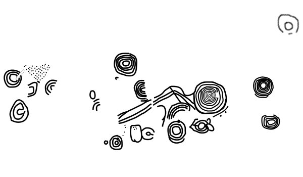
I’d only planned a quick visit to Long Meg this time but ended up staying far too long. The circle is a real grower and every visit seems to turn up something I haven’t noticed before, perhaps it’s the way that it’s difficult to see the whole circle at any one time, the gentle slope and the trees near to the track always seem to obscure some of the stones. The small size of the field makes trying to get a wider perspective of the site impossible too. Two things struck me this time, the first was the sheer size of some of the stones, they seems much larger than I’d remembered them. The other thing was that Long Meg is offset from the entrance stones, again I’d not really noticed that before. Burl suggests the stone was here before the circle based on the fact that the flat face with the carvings is 20 degrees off from the perpendicular of the axis through the centre of the circle. My own feeling, not based on any evidence, is that it may be the other way round, the circle was already here when an existing expanse of carvings were quarried out of bedrock (or even a boulder like Copt Howe) and brought to the site as Long Meg, some of the carving seem to run off the edge of the stone and the whole design looks like it should be rotated 90 degrees. The carvings themselves which are on just one side seem to be arranged in 3 groups. Those at the bottom consist of a spiral, an unfinished spiral or set of rings and above that a semi-circle of rings. The middle section is clearer and has a prominent set of concentric circles and a spiral below and to the right as well as some other fainter rings and grooves. The mid-upper section is faint but has a spiral and worn or shallow rings – there are also quite a few straight and curved grooves that may form an unrecognised design but natural marks over the whole of the surface add to the confusion. There don’t appear to be any marks on the top section of the rock.
Stan Beckensall mentions other marks on some of the stones in the circle but he’s not quite clear where they are. He talks about stones to the west of the road and as the road passes through both sides of the circle this could be either side. From his illustrations I think he means the side closest to the farmhouse with the marked stones being numbers 5, 6 and 7 counting west from the road, I can’t be sure as I couldn’t see any definite marks on any of them.
Chris Collyer
I would suggest a different parking spot to Ironman. When I got to the site there were already a few cars parked opposite the gate and talking to a climber later he said that space could often be packed during busy times. About 300-400 metres further northwest along the road there is room for several cars next to a track and footpath that lead south to Great Langdale Beck, from here it’s an easy walk back up the road to the gate. Once I’d actually got to the huge boulder I was a little disappointed that the carvings weren’t more clear, it was about 5.30pm so the sun was behind the flat east facing side with the carvings and there was no shadow to add definition to the marks. With a plan of the site it is possible to trace the position of the rings, grooves and cups and the layout slowly unfolds before your eyes, Ironman’s map theory seems particularly appealing – this valley would have made an easy route for the movement of axes. While chatting to the climber he said he was aware of the carvings but didn’t know much about them, when I showed him the plan he proved remarkably adept at finding the various parts of the carvings – better than I was.
For anybody planning a visit, morning up until midday might be the best time to see the carvings, but the site is in a beautiful location and would be worth a visit at any time of the day.

Lozenge and possible hatching pattern on Stone 3. The carving is close to the edge next to Stone 2


A welcome evening return to Castlerigg this time, a sunny summer evening brings out the tourists though, there were kids clambering over the stones, a frisby throwing competition in the middle and even a group of elderly couples with a fully laden picnic table at the site. Not too much of a problem for me though as I was here this time to look at the carvings on the stones particularly the elusive spiral – second attempt, second failure. I managed to find the other 4 known marks, 2 of them are very faint and none are spectacular. There are several other stones that *may* have carvings that have yet to be recognised but the geology of the rock makes imagining cups, rings and grooves on their surface too tempting.
Working from Fitzcoraldo’s plan of the circle, Stone 1 has the spiral on the inward facing side (facing towards the setting sun), Stone 2 has a faint wide ring, I thought I could see a central cup too but Stan doesn’t mention it. Stone 3 has a lozenge or hatching pattern but there are natural marks in the rock right next to it, while Stone 4 has a quite deep but difficult to spot partial ring and a cup at it’s top edge. Stone 5 is the easiest to see and is a clear narrowly cut lozenge.

Carved stone to the left, largest stone to the right. Looking roughly in the direction of Long Meg
Sir J.Y. Simpson wrote about Little Meg in the 19th century-
‘Two or three cairns or tumuli existed locally …. One of them, of large size, stood on land belonging to the free school of the township of Maughanby. After removing from its central mound or barrow a quantity of cobble stones mixed with earth, several large stones, one of them only erect, were found arranged in a circle about eighteen feet in diameter. Several of them were buried beneath the projecting edges of the barrow. In the centre of the circle was placed a semi-ovoid cist formed of rough stones, and measuring only three feet nine inches in length, two feet four inches in breadth and ten inches in depth. The cist contained an urn, burnt bones and charcoal. The only ornament upon the rude urn was a raised line near the top.’
A lovely little site but a real jumble of stones. One stone struck me particularly, the large block to the right of the carvings is much bigger than the rest and wouldn’t look out of place as part of Long Meg’s circle, but it’s the low rounded carved stone that obviously stands out. The mix of a spiral on one side that partly interlinks with the concentric circles on the other side really intrigues me – as usual trying to find an explanation is guesswork but it’s tempting to suggest some kind of sun/moon symbolism in the carving. Alternatively, the layout is suggestive of a representation of the positions of the circle at Long Meg and the large ditched enclosure just to the northwest – the two structures intersect along one edge. The stones look like they have been moved but if this stone was facing into the cairn was it meant as some kind of map or reminder for the spirit of the person whose remains were found is the central cist?

The carved stone which faces inwards to the circle. Go on Stan, pull the other one!

A easy site to find but not an easy place for parking. Leaving the village of Glassonby a road leads northwest past the gate into the field with the stones but it’s difficult to park without blocking the gate. 200-300 metres further on there is a sharp left bend in the road where there is some room on the right hand side, but it’s still a bit awkward. Carry on another couple of hundred metres and just as you get to the bridge over Hazelrigg Beck there is room on the left for 2 or three cars next to a footpath, from here walk (carefully, it’s quite busy) back up the road to the gate. Once in the field the ring of stones is easy to spot ahead and to your right.
When I got there it was heavily overgrown with grasses and various stinging plants and didn’t look anything like most of the other pictures on this page but it was still easy to trace the oval of 29 small stones, the size is roughly 16 metres by 14 metres. I’d really come to look at the carved rock which again was easy to locate but the carvings on the inward facing side of the stone were just about impossible to see. With a bit of imagination and with Stan’s drawing I could just about kid myself I could see them and slight indentations can be felt in the rock, but it was a bit of a disappointment. There was once another carved stone on the southern edge of the cairn but this has since disappeared.

Welcome to GCHQ Scarborough. Please come in, have a look round, make yourself comfortable.
Seamer Beacon can be seen from a fair distance from the south especially from the Starr Carr area about 5 miles away. Unfortunately Fitz failed to mention that at least some of the hill forms part of GCHQ Scarborough – I don’t know where he parked but the entrance I found was less than welcoming ;-) A sign did state however that there was a ‘permissive’ path up the hill, it’s actually a public footpath so yah boo sucks to GCHQ.
The stone folly will be Baron Albert’s Tower which was built in the 19th century on the top of a levelled barrow. Hagworm Hill is about 44 metres in diameter and 3 metres high with a silted-up 2 metre wide ditch. When it was excavated in the 19th century several burials were found in stone lined cists, although I don’t know whether the stone was left in the barrow or transported to a local museum. A excavation in the 1970s found more burials, sherds and flint, it also established that the barrow had an outer kerb of stones and a smaller internal stone ring. Could it be that these stones were Elgee’s stone circle?
There’s bit of confusion about the stone setting at the base of Blakey Topping hill. Burl says it is so damaged that it cannot be said for certain that it was ever a circle, Dyer on the other hand thinks it was, as does JC while the scheduling report calls it an alignment. As the first three cover the stones in their own books I’ll give a brief summary of the scheduling instead.
It mentions the 4 stones calling them ‘roughly hewn sandstone boulders’ with 2 of the stones on the west side in a SSW to NNE alignment. The stone to the north is 80cm high but was once higher, the top having been broken off. The southern stone is 15 metres to the SSW and is 1.7 metres tall. On the eastern side of the alignment the southernmost stone is now part of the field boundary and is 20 metres to the southeast of the southern stone on the west side. It stands 1.3 metres above the modern ground level with a slight lean to the south. The north stone of this pair has been moved at some point in time and is now 85 metres north of its partner and is 1.1 metres high.
The report then mentions that there would originally have been more stones in the alignment, the others having been removed in land clearance or for reuse elsewhere and it goes on to speculate that the line of these stones would have continued the curve formed by the 3 stones still in their original positions or formed 2 parallel rows, part of which survives as the 2 western stones. The report makes almost no mention of the hill.
A two for the price of one fieldnote. My first attempt at Blakey Topping was on the 6th July when I parked at the carpark that overlooks the Hole of Horcum, and walked east along the Old Wife’s Way. A little way down the track the hill starts to become visible and as you continue its strange shape becomes clearer, my first though was that it resembled the hill in Close Encounters and I was tickled when I got home and read that Julian had the same impression. From this western angle Blakey Topping is less a ‘tit’ hill and more a giant nipple. I decided not to continue on to the stones at the base this time as it seemed just too much of a walk and decided to approach the hill from the opposite side on another occasion, which turned out to be a week later.
This time I drove along the same forest track that leads past Howden Hill and parked next to Dargate Dyke – there is a charge for driving through this part of Dalby Forest, an unreasonable 4 quid. From here Blakey is about 2 miles to the northwest but I had thrown my old bike into the back of the car and was prepared for a leisurely peddle to the hill and stones – not so. First of all I took the wrong track due to having to rely on my map reading skills as the tree cover was playing havoc with my GPS. Twenty minutes and one detached chain later I managed to find my way back to where I had parked the car... Setting off again on the right track this time the land immediately drops down nearly 100 metres in a distance of only 500 metres which was pretty hairy on an old bike with iffy brakes, but safely at the bottom I turned left and continued west to Grain Beck where I was greeted by a couple of barking dogs from the house at the southeast end of Thompson’s Rigg. The dogs were quickly pacified and I continued onto the flattish plain of Thompson’s Rigg. From here the still distant Blakey appears a completely different shape to the western approach. The flat top and steep sides are replaced with a conical form that seems to almost exactly mirror Howden Hill when seen from the same direction – the southeast, which I found rather peculiar.
Compare these pictures of Blakey-
themodernantiquarian.com/image.php?image_id=16192
and Howden –
themodernantiquarian.com/image.php?image_id=16158
Again like Howden the effect diminishes as you move round to the southwest where the stones are and it become just another hill (a very pretty one nevertheless). All the way along the track I had been careful to re-close all the gates I had been through but as I reached the fence and gate that the stone setting stood behind I found the gate wide open, and just beyond it close to the stones were some young cows. Wanting to avoid the beasties I took a right turn and went along the edge of the fence and had to content myself by viewing the stones from over it so I can’t really say if they form part of a circle or an alignment as the scheduling report suggests. If I had had the presence of mind I would have stormed the gate and closed it before the cows could come through it, which only occurred to me as I made my way back. Turning round I started back to the gate only to find the cows had already come through to meet a walker who was heading north along the fence, he didn’t seem at all bothered by them but there was no way I was going past them – maybe next time...

View from the southeast, partway along Thompson’s Rigg. The shape of the hill from here is almost identical to Howden’s Hill.

From the southwest the hill form is part way between flat top and conical.

Picture taken from The Old Wife’s Way.
From the west Blakey Topping is a classic ‘Close Encounters’ hill.

View of two of the stones from over the fence. The cows were just off to the left – honest!

Seen from the southeast. Howden suddenly pops out at you as you round the corner close to Langdale End.

I’m not at all sure if I agree with Julian’s sacred hill theories, and his choice of hills that he feels might have been of significance to prehistoric man seems rather arbitrary at times. It seems to me that pretty much any hill could have been seen as special to the local inhabitants, as could any river, lake, valley or any other landscape feature, but in the spirit of investigation and with an open(ish) mind I decided to pay a visit to Blakey Topping and Howden Hill.
Howden is easily reached from the village of East Ayton by a road travelling north through the picturesque Forge Valley and Scarwell Woods which line the edges of the River Derwent. Due to the number and size of the hills in this area Howden doesn’t come into view until you round the corner just before the bridge at Langdale End when suddenly *bang* it’s right there in yer face. The effect was the same as when I visited Avebury last year after not having been there for several years and I had forgotten the way that Silbury suddenly leaps out at you as you head west past Waden Hill. Perhaps the old man is on to something after all.
I didn’t attempt to climb the hill as I had already read Porkbeasts notes plus I was short of time as usual – anyway it looked one hell of a climb. The conical effect is only seen from the south/southeast as once you move round to the west the spine becomes apparent which diminishes the visual impact. It’s still a beautiful hill though and as Julian says it is set in a faerie landscape. Whether I think it was a ‘sacred’ hill or not, well the jury is still out on that one I’m afraid – maybe I needed to climb it for a full appreciation.
Satellites could spot ancient remains
From the BBC –
‘Satellites really could be used to spot ancient archaeological treasures buried underground, two researchers in Israel have shown.‘
I think they’ve seen me!
The buttermakers at the Butterbumps.

The cows were only small and the ones closest are stood in a slight dip in front of one of the barrows.
I really like this little barrow cemetery. After driving through the pretty town of Alford a series of twisty roads lead you out into the wilds of east Lincolnshire, you can’t go much further before you fall into the sea at Chapel St Leonards. This isolated rural position gives the dozen ploughed closely set barrows a lovely peaceful atmosphere – few cars ever pass by on the nearby road and the quiet is only occasionally broken if the wind changes direction and carries the sound of the seaside fairground over from the coast. In the past when I have visited the site it has always been deserted, this time it was home to a herd of young cows. As soon as they saw me walking up the track they stopped their chewing and came over to the fence that surrounds the barrows, I didn’t go any closer as the fence is only flimsy. Funnily enough the presence of the cows allowed me to get the only half decent pictures I’ve ever taken of the site, none of the low mounds are over a metre high and are usually overgrown but the cows added some kind of scale to the photos – thanks chaps!
Finds from the site include a whetstone and a dagger. C14 dates the cemetery to around 1750BC.


The ‘below ground’ part of the trunk. In the middle is the cut away bracket used to tow the tree to it’s resting place. To the left are marks from some of the 50 axes used to shape, de-bark and dress the tree.


I have to admit my main reason for visiting Flag Fen was to reacquaint myself with the timbers I had last seen on a cold windswept beach near Hunstanton 4 years ago. At the time I had dragged along the girlfriend of the time and her 2 kids to watch a ring of wooden posts and a central trunk very slowly emerge from the water – I don’t think they were ever conned by the promise of ‘a day at the seaside’ again after that.
For some reason I’d left it a long time before going to see the remains of the circle in their wooden tanks, perhaps I needed to put some distance between them being there on the beach and being here at Flag Fen. Francis Pryor’s book had reawoken my memories and brought back the feelings of that day – I’m not going to go into the rights and wrongs of the subject, I think the issues were well covered in the Forum posts of the time.
Walking into the large open fronted barn was a strange experience. The central timber is placed at the end and it was almost like walking into some kind of hallowed hall with the trunk forming an alter as its focal point. The smaller split timbers that made up the continuous circle were laid out under the water, some were in with the trunk while others were in a separate tank. The view of the timbers was difficult due to the layer of green pond slime that seemed to be growing on the top of the water in one tank, I presume there is a reason why the water is not changed regularly. I was almost tempted to put my had below the water to touch the posts, but didn’t, partly because I wouldn’t want to cause any damage to the 4050 year old wood and partly because it just didn’t seem right – disrespectful somehow.
I spent quite a while in the barn and there was nobody else around. While I was there something whizzed silently above my head, I looked up to see a young swallow on the wooden beams of the barn being fed by it’s parent before the adult flew off again to gather more insects for the youngster. I was struck by the whole ‘life, death, rebirth’ thing, the timbers had grown, been felled, shaped, moved to a sacred place near the coast, erected and become the centre of ceremony, abandoned, covered in rising water and then peat, been forgotten about, uncovered by the sea and returned to the land of the living, become again the centre of attention, been dug up and brought here awaiting the next part of their journey. The swallow had been born in Britain, grown up then flown to Africa, overwintered there and then returned to Britain to raise it’s own offspring who would repeat the cycle. Somehow I felt that seeing the timbers again had completed the cycle for me too in some way that I can’t explain. A sad but quite moving experience.

Entrance to one of the Bronze Age round houses.
Who lives in a house like this? – me please!

Bronze Age round house. Weaving frame complete with loom weights.


Bronze Age round house. I’m not sure if the chairs are a bit fanciful – I almost expected a little gnome to be sat on one!

Inside the Iron Age round house. It looks a bit sparse – I’m sure there would have been more decoration.

Another view of the trackway. The lines of posts are from (roughly) left to right.

Remains of the Bronze Age trackway. The lines of posts are from the bottom left to top right (following the line of the large timber in the middle and also marked by the info boards attached to the wooden railings).
I’d never got round to visiting Flag Fen but after reading Francis Pryor’s Seahenge book my appetite was well and truly whetted. As it was Fathers Day I had parental visiting obligations to attend to before heading off towards Peterborough and having made a late start as usual, it was 3pm before I got there. I was worried about navigating around the southeastern side of the city after I had left the A1 but luckily Flag Fen is well signposted on the Peterborough ring-roads and it’s easy enough to follow the signs out through an industrial estate and then out into the low lying fens to the site itself. When I got there I was rather surprised to see only 6 cars in the car-park – not that I was complaining, I think most of them belonged to the staff who were very helpful and informative giving me a potted history of the site. Just outside the centre I noticed a container of umbrella’s for the use of visitors on wet days – I thought that was a nice touch.
First stop was the Preservation Hall, lots of displays and information on the way in and ‘atmospheric’ music playing unobtrusively inside. Many people might not get excited at what seems like a random jumble of old timbers on display inside the building but it’s not everyday you get to see the remains of a bronze age trackway still in situ. Thanks to the info boards it’s possible to work out the individual lines of posts that formed the 1 kilometre link between the dry raised areas of Fengate and Northey between 3300 and 2900 years ago.
Next stop were the reconstructed Bronze Age round houses. I was surprised at the amount of room inside while at the same time still being cosy – I want one! The interior was laid out as they believed these dwelling may have looked, with carved wooden beds, weaving frames, tables as well as a hearth etc but there was no sign of any reproduction bronze tools – probably thought to be a bit too ‘portable’ to leave on display.
Next up was the Holme-next-the-Sea timbers housed in their own barn – I’ll cover those in the Seahenge section.
By now I was getting short of time (Flag Fen closes at 5pm) so I only had time for a quick look at the rather fine Iron Age round house and like the others it was well furnished inside with suitable tables, beds, benches, wooden and pottery bowls and frame for the preparation of animal skins. A quick look at the excavated section of Roman road and then onto the museum. It’s only small but has a decent display of the various finds from the site including part of what is believed to be the earliest wheel so far found in Britain. I tried to get a photo but it was on a revolving ‘thingy’ and in the low light the picture came out blurred. My favourite displays though were the bronze swords, daggers and spear heads – the ones shown on the front cover of the ‘Seahenge’ book, for those that have it.
Time to go before the staff shut the gates and there were still parts of the site I hadn’t looked at or had had to rush, the web site recommends a couple of hours to look at everything, I would suggest much longer. Nice place, nice day out.
I’d visited the southern part of Dane’s Dyke in the past on the way north either to the seaside or to Rudston but had never given it the examination it deserved. This day I planned to visit the various sections of the bank and ditch after having a look at Starr Carr. In the end I didn’t get to the Mesolithic settlement site and it had gone 4pm by the time I reached the carpark at the RSPB nature reserve of Bempton Cliffs which is fairly well signposted and makes an excellent start for a visit to the earthwork which is about a mile further east along the coast. After spending about half an hour watching the thousands of puffins, guillemots and gannets the weather took a turn for the worse and huge black clouds charged in from the west. There was no way I would make it to the dyke before it started raining so while watching everybody else dashing back to their cars I set up my camera and happily snapped away at clouds speeding over the cliffs and out to sea. Then it started raining – and I mean *raining*. I packed the camera away and started what seemed a very long walk along the cliffs in the pouring rain. Everything got soaked, the rain went right through my coat, the long wet grass left my trousers with water running down the inside and I had my own personal lake inside my boots. Strangely though it hardly bothered me, the cliff edge was deserted, just me, the birds and the elements, which is what it must have been like here for thousands of years – I have to say I really enjoyed that walk.
Eventually I got to the northern terminal of the earthwork which is best described with words like ‘huge’ and ‘looming’. There was still some evidence of the ditch on the western side but both bank and ditch finished just short of the cliffs, I’m not sure if it was designed that way to allow a narrow easily defended entrance to the enclosed area or whether the gap had been created in more recent times. Trying to get some photographs was a nightmare in the rain but I a snapped a few pictures showing the bank disappearing into the distance then made my way back to the car along the field edge this time, scouring the soil for flints but as usual found nothing.
Next stop was the central section of the earthwork where it is cut through by the B1229. Parking was only possible on the grass verge and the view to the north was limited by the trees that partially cover the bank – the view to the south was much better.
Following the road it takes a turn south at Flamborough village and doubles back west as the B1255 where there is a sharp left signposted turn as the road dips through a small wood. As you drive down the track the bank is just to your left all the way down to a carpark where the dyke ends and a gully runs down to the sea.
As it was getting late I only had time for a quick look round and as the area was covered with trees it was difficult to figure out just were the earthwork ended and the natural features began, I’m guessing they were extended and built up by the original builders anyway. At least it had stopped raining and I managed to get some photos of the bank under the gloom of the trees before setting off home. The next day I went to work in wet footwear – my coat took about three days to dry out...

Southern end of the earthwork hidden in trees. The path shows just how steep and high this Bronze Age bank is


The northern end of the bank looking south – it continues into the trees in the distance.

The northern terminal of the bank. There is a sheer drop down the cliff into the sea behind me!
The name of this huge earthwork is misleading, in the past it was believed to have been built by Danish invaders, then more recently Hawkes and Dyer recorded it as Iron Age. Current opinion is that it was constructed in the middle to late Bronze Age as were many of the defensive/boundary banks and ditches that cover large areas further west on the Yorkshire Wolds, although it is entirely probable that it was later used and modified during the Iron Age and even as late as the 9-10th century AD.
The bank’s construction started with a layer of compacted stones which were overlaid with chalk blocks, rubble and earth and covered over with a layer of turf to a height of between 4-5 metres and a width at the base of about 20 metres. To the west of the bank the ditch, which has become partly infilled over time, is estimated to have been around 3-4 metres deep and up to 12 metres wide. In places the existing single ditch/bank is joined by another smaller bank on the western side, and occasionally a pair of banks.
It is interesting that the southern end of Danes Dyke starts (or ends) at a natural deep gully that leads down to the sea and it could be that this natural defensive feature was the inspiration for the earthwork which runs north for two and a half miles to the northern edge of the Flamborough peninsular. The enclosed area measures about 5 square miles and is naturally defended to the north, east and south by cliffs making it an ideal fortified settlement site although there seems to be no obvious signs of occupation except for a single barrow and I have yet to find any archaeological information for the area. The bank and ditch are cut in half by the B1229 and are further bisected by the B1255 a little further south – there is a car-park and paths down to the sea at it’s southern end and access through the RSPB reserve to the north – the map ref is for this northern end.
‘More than 30,000 people gathered at Stonehenge in Wiltshire to mark the summer solstice....’ rest of story at –
news.bbc.co.uk/1/hi/england/hampshire/dorset/3008828.stm
That’s a lot of people. I wonder who’ll be first back with fieldnotes and photos.

Castlerigg Plan – Version 1 (cribbed from the information board at the site)
Location, location, location – Castlerigg for me is all about the setting.
The stones sit in a natural amphitheatre of hills that must have impressed the circle’s builders as much as they impress the modern visitor but I always have trouble figuring out which hills are which from just the OS Map – hence this plan.
If anybody spots any mistakes or can add any more information, particularly about where the various sunrises/sunsets occur in relation to the hills please let me know.
