
Got this pic from the roadside. I don’t think there is any public access.
Looks like it could do with a trim!
Got this pic from the roadside. I don’t think there is any public access.
Looks like it could do with a trim!

This Neolithic henge is just of the A30 near Bodmin.
Truly an enthusiasts site.
The only other Cornish henge I know of is at Castlewich in East Cornwall.
homepages.rootsweb.com/~marcie/kernow/austell2.html
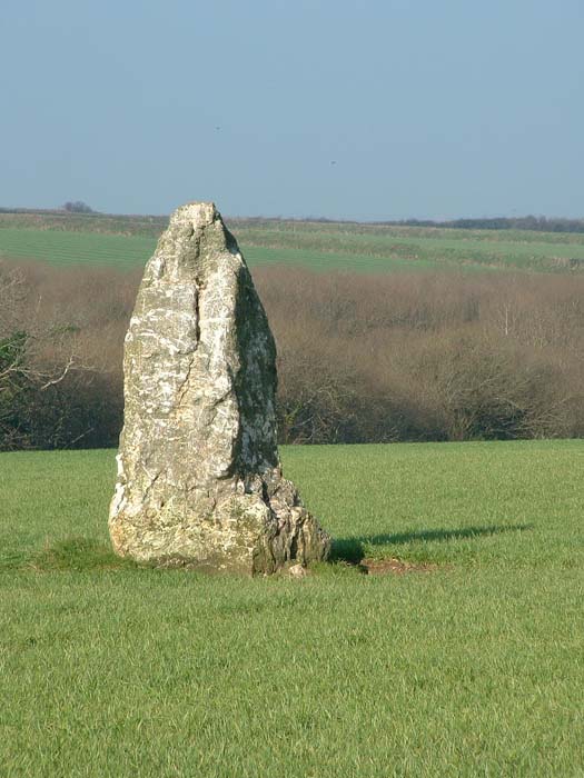
A giant travelling one night over Gwallow downs, near Charlestown, was overtaken by a storm that blew his hat off. He immediately ran after it, by having a large staff in his hand, which rather impeded his progress, he pitched it in the ground, until his hat was secured’ but after wandering about for some time in darkness, without being able to find his hat, he gave over the pursuit, and returned to secure his staff, but this, also, he was unable to discover, and they were both irrecoverably lost. When daylight appeared, the hat and staff were both found by the inhabitants, about a mile asunder’ the former lying on the ground, the latter in a perpendicular- position. The hat lay on Whitehouse downs, and bore some resemblance to a mill- stone, very thick, but not of great diameter. This singular stone continued in this place till the autumn of 1798, when some regiments of soldiers being encamped round it, fancied, as it was a wet season, that this giant’s hat was the cause of the rain; so they raised it on its edge and rolled it over the cliff into the sea. His walking staff still remains stuck in the ground near the Charlestown mills, being an enormous pillar of granite, about twelve feet high above ground, commonly called Longstone. It is no less curious than true that the Longstone is a perfectly isolated piece of granite, there being none within miles of the position it has so long occupied.


All the standing stones in this area seem to be Quartz.
See St. Eval Stone, Ninemaidens, MenGurta, Pawton Quoit etc

This site was once part of an Iron age village. The passage of this one is about 8 metres long.
It can be found about half a mile north of Constantine on the B3291 in a field opposite Trewardreva House.
This site is also known locally as the Piskey hall
Hurling is an ancient Cornish game played by 2 teams with a silver ball. The practise once took place all over Cornwall but now it is only continued at St. Columb Major and St. Ives. Don’t confuse Cornish Hurling with Irish Hurling. The Cornish versions are played without the use of sticks.
At St. Columb the game is always played on Shrove Tuesday and 11 days later on a Saturday.
People say the sport originates from some kind of pagan sun worship, the ball is said to represent the rising sun in the early spring and it is a well known as a fertility/ good luck symbol.


At first I thought this was some kind of pagan offering, After getting up close I found that it was HUMAN ashes!
9/2/2002 CE


The site of a fogou at Boden Vean, Cornwall, has been known for some time and was rediscovered in 1991 following the digging of a water pipe trench by the landowner (Mr Christopher Hosken).
The site was then planned and drawn by the Cornwall Archaeology Unit who concluded that it was the remains of a partially collapsed fogou.
Below is the info from rlaha.ox.ac.uk/archy/abst401.html
(this link now dead) but from a cache search on google it is possible to read the following....
Archaeometry 40, 1 (1998), 187-216
A geophysical survey was conducted at Boden Vean, St. Anthony Meneage, Cornwall, over the site of a buried chamber thought to be the remains of a souterrain or fogou. A combination of geophysical techniques was successfully applied including an experimental microgravity survey over the location of the buried chamber itself. Magnetometer survey revealed a complex palimpsest of archaeological activity extending throughout the surrounding landscape, centred on a rectangular ditched enclosure containing the fogou. A series of gravity anomalies were recorded in the vicinity of the latter which were consistent with the collapsed section of the feature recorded by the Cornish Archaeological Unit. Further gravity anomalies suggested the presence of additional void features, possibly related to the extended passages of the fogou.

Looking thru the bars of the fogou

The interior of the fogou now appears to be filled with sand.


Colour pic and description here
Totally destroyed, only a grass covered long depression remains.


Denis took this one in Apr 1981


scanned from Uncle Denises slide collection not sure what date.


Couple of pics here. Originally one of a pair of circles.
A good photo and guide.

The stone is sited on a school playing field
You have been warned!! :(

The stone appears to be on a leyline!
(Or perhaps a sportsfield)


