A good synopsis of the history of the stone together with recent events.
juamei
[Second visit 14th July 2002]
I popped back here whilst wandering around the common again, after inspecting several maps as to the actual location of the ditches. The addition of a much clearer head helped me spot the single bank and ditch visible from the fenced in footpath quite easily.
Basically, as you start on the path through the golf course, you cross the defenses which go away from you at right angles on either side. Note, you may need some imagination to see this part.
Now walk about 100 metres down the path keeping an eye out either side for the defenses to circle back round to you. You’ll see them as first a bank, then a ditch in the middle of the fairways on either side. And thats it.
With a bit of illegality, you can follow the path of the bank (or even ditch) most of the way round the hillfort, by trespassing onto the golf course, though of course it is illegal (and a bit dangerous).
visted 02/07/02
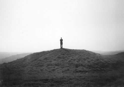
After a fairly lengthy quest starting with a very drunken conversation in a club, I finally found a longbarrow in Richmond Park. Ok so it might not actually be one, but until I’m convinced, it’ll do for me.
To find it, start at Pembroke Lodge Garden and head south. Take the path slowly diverging from the road to the west and you’ll walk straight across the barrow. It is about 40m long, 20m wide and 2-3m high.
It has been reduced to having two peaks (one at either end) and a dip in the middle, which may well have been caused by gravel digging. At least one other mound in the park has disapeared due to this. In addition you should be able to easily identify the barrow due to the large oak on the western end.
The site itself is peaceful with the occasional walker strolling past and worth a visit despite the delapidated state.
The most probable of 3 possible longbarrows in the park, in addition to Henry VIII Mound.
It is listed in the GLS&MR as a possible longbarrow and the Richmond Park archeological survey (1992) is confident about its authenticity. However other experts have dismissed the possibility of there being any longbarrows in Richmond Park (or any other London park it seems).
Visited 30/6/02
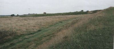
Yet another depressing London site. This entire hillfort is covered by an exclusive golf course; bunkers, leveled off greens, hazards, the lot. The only legal public access on the hillfort is a 3 metres wide path, that goes perfectly straight across the fort running north-east to south west.
I don’t doubt that this is actually a hillfort but it is very hard to distinguish on the ground exactly which earthworks are ancient. A couple of bank-ditch-bank combinations seem slightly more excessive than a normal golf course would desire, 7ft from top of bank to foot of ditch, but the extensive restructuring for a select few to play golf has destroyed this as an effective encampment.In addition to the caged walk with a 6ft wire fence either side of you for 200+ metres, you can walk around the outside of the course, the outer side of another 6ft fence.
Prehistory, but not as we like it.


The best view of the mound from the side.
If you squint you can just about see its structure...


View from the top of the mound to the west.
Its not clear from the photo but we could literally see for miles.

- Visited jubilee w/e -
I visited this site the same w/e as Arthur’s stone (near Dorstone) and Harold’s Stones, and I have to say this was my clear favourite.
The stones are indeed massive, being over 4ft in width at their base, which my meager maths tells me is over 12ft in circumference. They sit by the edge of a field in a plain surrounded on all sides by hills, which provide a beautiful setting.
I checked all the stones for markings, but I wasn’t able to discern any, unfortunately :-/ Also someone appears to have dug underneath the fallen stone (presumably why it fell...)
This site is the sort of place one could lose oneself for several hours, just sitting peacefully reflecting the insolubles of life.
[visited 06/05/02]
After dragging my gf up and down, either side of the mound, I finally twigged that it was inside the fenced off gardens and so we drove to the nearest carpark on our way out of Richmond Park.
This is another heavily altered prehistoric monument within the confines of London. Its top was levelled off a couple of hundred years ago and at some point slightly more recently a spiral path was constructed to its summit. Nowadays a few benches reside at the top facing out to the west on a concrete platform.
Well having finally made it, we were awestruck by the views to the west, you can see to the horizon and on a clear day, I imagine you can see to Windsor (there was an arrow pointing it out :). The Thames isn’t visible due to tree coverage, but winds its way around the foot of the hill the mound sits on top of, less than a mile away.
And over to the east was a most unexpected sight, a “keyhole” view of St Pauls aka Temple of Diana. A legally protected view across 10 odd miles of London. Tbh, you’ll probably need a telephoto lense to take advantage of it though.
In summary, in an area starved of prehistory, this is well worth a visit.

Some stones presumably from the destroyed south side of the circle, left lying about in the wood to the east of the circle.
[visited 15/04/2002] I went and found the London stone after work one day. Poor bastard thing that it is, trapped in a glass cage in the wall of some bank, some trophy antiquity claimed by foreigners, walked past by uncaring and unknowing wageslaves. Uprooted from its ancient home to ensure clear passage for more cars, more trains.
Its not even whole anymore, I see at some point in the past a magnificent menhir. Yet it was chopped up, torn apart and now a piece barely 50cm high is all that is left. Its said if the stone ever leaves London then London will fall. For some reason I find this quite ironic.
Worth visiting for two reasons, first so its memory lives on despite its forlorn state. Secondly as a reminder that this could happen to other sites unless we pay more attention.
This is a beautifully bleak place. Its well worth the money to the NT to just have a wander round the ruins, and get the amazing views from the top. Prehistory wise there isn’t that much to see except the mound itself and at least 5 barrows within view from the top.
The whole area does oooze of the ‘mother spirit’ however and its not hard to imagine this hill being revered, standing solitary as it does between the two huge banks, that seperate Purbeck from the world.


Three stones are visible arcing away from you from right to left. Unfortunately the wood the circle is in prohibits complete photos.
This site was merited a flying visit via the pub in Chaldon (at the bottom of the hill). It is 5 or 6 barrows on another ridgeway path in dorset.
Only two of the barrows are in good condition, the rest are eroded due to walkers and probably agriculture.
Quite a nice spot to stop for half an hour or so, but better pickings can be found further east in purbeck.

Visited 30/03/2002
After a non-neolithic day near my favourate sites, I escaped the family and headed off up here for sunset.
It had been a few years since I was last here, its the first time I’ve been up here for sunset and I wasn’t disapointed.
I situated myself on the south side towards the east entrance and watched the sun set behind the Iron Age ramparts, all the while feeling more and more peaceful.
This site oozes power and peace in a strange combination. It always invigorates me more than the obligatory run up the ramparts would alone.
All in all a successful re-aquaintance with this lovely hill.
Henry VIII is rumoured to have stood on this mound to watch for a signal from the Tower of London to announce the beheading of Anne Boleyn.
Apparently this is just a myth as he was in Winchester.
Situated on the west edge of Richmond Park, probably a bronze age mound.


This is slightly hard to find unless you remember Julian’s comment that it has a signpost handily situated next to it. Even then the tree is a more useful guide.
Both ends of the barrow are still present, but the middle is completely gone. The non-chambered end has been utilized to make part of a wall, but is still 3-4 ft high.
A nice peaceful site with views of the barrow cemetary and hardy’s monument on the ridge above, to the north and the sea to the south.
Kudos to the man with the mullet and his family, who I met there.
Visited 01/09/01
Strangely depressing circle surrounded by a barbed wire fence and stinging nettles. Definately moved from its original location to the west(?) and containing stones possibly from an original stone circle, stone rows and/or a chambered long barrow.
Wonderful views of portland and chesil beach redeem its extremely poor condition, but its neglected and almost downtrodden state make it a circle to be pitied.
It has had a varying number of stones over its time, I counted between 10 & 15.

Visited 28/12/01CE
Lovely barrow cemetary on top of the hills on the edge of purbeck. Its about 1 mile straight up the side of the hill from Rempstone Stone circle so both can easily be visited in a visit.
Note the location of the barrows is to the west of “Nine Barrows Down” marked on the map.
The cemetary itself consists of one neolithic long barrow and 8 bronze age? round barrows. Two of the round barrows have clearly visible ditches and one of these is about 15-20ft high. The round barrows are spread in a line along the crest of the hill running west to east, seemingly getting larger the further east you go. The long barrow is located at the east end about 10 metres south of the line.
The views are as amazing as the earthworks. Poole harbour, wareham, poole and on a clear day bournemouth, to the north. Swanage and most of purbeck to the south. Also if you look west along the coast, you can see the distinctive outline of Golden Cap. I was at the cemetary for sunset but unfortunately the cloud cover was too dense to see much, but I imagine the sun sets pretty close to Golden Cap from that angle.
Visited 28/12/01 at the same time as Nine barrows down on top of the hill above.
Walking around the wood I found another 10+ stones scattered about, presumably from the destroyed half of the circle. I would be interested to know if a resurrection of the circle would ever be possible as I found its desecrated state rather depressing.
I also noticed that the “main” stone, with all the cups and offerings, had a marking carved into the side of it. Unfortunately I didn’t have a camera with me but it seemed to be a symbol for the sun.
(from northcoastal.freeserve.co.uk/holme_beach.htm)
27th November 2001
Holme Village Hall Meeting
A meeting was held in Holme Village Hall tonight for what has been called the last of the consultations regarding the fate of ‘Seahenge’.
David Miles Chief Archaeologist of English Heritage explained to the villagers of Holme-next-the-sea what had happened to change the decision to bury Seahenge deep into the clay of Holme beach. A decision made at the last consultative meeting in the village hall in October 2000, when it was suggested that there was neither money nor expertise to preserve the timbers on dry land.
When various archaeologists and academics from the international scientific community urged
preservation of the timbers as burying them could not guarantee their survival, English Heritage
released funding to Flag Fen for further investigation of the timbers.
The Seahenge timbers, which have been dated to the spring of 2050BC and 2049BC using pioneering dating techniques, are now being studied using new technological advances in laser scanning which is allowing scientists to study, on computer, three dimensional detailed images.
This study is revealing in fine detail exactly how the timbers were cut and shaped and showing what tools were used. This, and other information, is unlocking the mystery of the builders of Seahenge.
Referring to the axe marks as ‘fingerprints’ a report from Flag Fen suggests that 38 different bronze tools were used and that a number of ‘builders’ appeared to be involved. That report concluded a whole community would have been involved in the building of ‘Seahenge’.
English Heritage has now agreed to release £50,000 for a 5 year programme of conservation and preservation to be carried out at Flag Fen Bronze Age Centre in Peterborough under the direction of Francis Pryor the Director of Archaeology and his wife Maisie Taylor. At the end of this process English Heritage will provide the funding for storage. English Heritage scientist Mike Corfield explained how the timbers could be preserved using a water soluble wax which process would make the wood solid. David Miles said no decision had been reached regarding display of ‘Seahenge’.
The option of placing the conserved timbers into storage would give access to scientists for research purposes and allow future generations to experience for themselves ‘one of the most important discoveries of recent years for British archaeology’. Another option to storage is the founding of a local trust to take over the responsibility of Seahenge and to raise the funds and find a suitable environment for permanent display allowing this present generation to experience this ‘important discovery’.
It was suggested at the meeting that there was now a breathing space of 5 years in which to come up with the answers to the eventual fate of ‘Seahenge’.
Holme Parish Council Chairman, Geoff Needham said “They have now realised the national importance of Seahenge and that they have no option but to provide the money for preservation.
The enthusiasm for long term display must come locally, but the Government will have to provide the money”.
There was no mention at all of the new discoveries on Holme’s beach. See ‘At Holme with Seahenge’ where three new photographs taken by John Lorimer show the central logs of a 22’ circle clearly showing what are assumed to be bronze tool marks.
This is a wonderful circle situated at the end (or start) of a 3 mile walk encompassing The Grey Mare, The Hellstone and another stone circle. I recommend following the proper footpath as the path coming from the North towards it (marked on the OS map) is effectively non-existent.
Whilst you are here, make sure you visit the site marked ‘Enclosure’ on the OS map. To find this from the circle, head north down the side of the field away from the circle and perpendicular to the path. On the other side of the field go through the gate and head left. Keep walking past some sinkholes? until you reach the crest of the hill. You should find a horseshoe shaped banked enclosure about 15-20 feet across overlooking the most amazing view.
The circle was special but the view from the enclosure was something else entirely. Wow.
If anyone has any ideas about what this may have been, I’d love to know...
I visited this site after discovering Silbury Hill to be fenced off and since I was in desperate need of solitude and peace, Devil’s Den is ideal.
I found the best way to actually reach the site is to follow the path along the side of the field until it tails off to the right. At this point follow the walked track through the plants (it was August) next to the field until you reach the closest point to the dolmen. The stones seperate from the Dolmen that Julian talks about in TMA lie here and the fence is usefully mutilated allowing easy passage.
The site itself is stupendous. I lay for an hour on the stone recollecting myself. I would recommend this site to anyone.
Having made the long trip down from london via stonehenge, primarily to climb and meditate on the top of the hill I was very depressed to find it fenced off.
It is impossible even to walk completely round the base of the hill at present (if it ever was), since barbed wire stops progress seemingly at every juncture.
Still, this being my first visit, I was awestruck at the sheer size and shape of silbury. It is easily within walking distance of West Kennet longbarrow, and a suitable consolation? is close by in the form of Devil’s Den.
Previous page1,001-1,035 of 1,035 posts