Four? overgrown round barrows with important connections to Wessex culture (apparently). The largest still standing is inaccessible to the south of the road and is 45 metres across, 2.4 metres high. It contained a cremation burial with various bronze & gold covered artifacts.
juamei
Probable remains of a chambered longbarrow, marked as “Burial chamber (remains of)” on the OL15 map. Ask at Combe Farm for permission to visit.
One of the two sites that the Bronze age Deverel-Rimbury culture is named from. Rimbury being a now gone barrow near Weymouth. The barrow was excavated in 1824 and numerous creation urns were found. Visitors should expect to find sarcen stones on top of the mound which covered the inhumations.
[visited 10/1/03] Very ploughed out and not much to see to be honest. In a county deprived of much prehistory, these need to be acknowledged but probably just one for the obsessives...
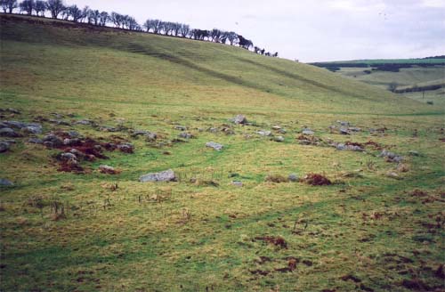
Only six barrows remain of the presumably seven that once stood here on a low ridge. Of those remaining, one is so denuded it is barely visible, two have been dug into and the other three have been ploughed low.
Its no longer the nicest of locations either; any views that once existed are gone, hidden by the trees...
[visited 10/1/03] Head into Thetford from the direction of the A1075 and you should go straight past this amazing earthwork. I took the road just before it and parked on the road just past it. This site is visually very rich though I believe most of the visible earthworks are Norman. The huge mound is very reminicent of Silbury Hill, though nowhere near as large. Plus this mound is surrounded by buildings and ramparts.
Watch out for the excessive mud in January as it makes climbing the Motte an “interesting” addition to the day.
[visited 12/01/03] Situated on the edge of the A146 just before the Stockton sign as you come from Norwich. This is a sad little stone, missed no doubt by 99 percent of the people hurtling past on a reasonably busy A road.
I noticed there was the remains of an iron nail or something attached to the top of the stone, so it may have been moved from its original location or it may not be a genuine ancient stone at all.
--
And I also see from the photos a huge gash in the side. Was this stone moved from a field?


From the south. Did they mean to make it look like a giant breast? (I’ll get me coat)


There is a trackway from the left hand shrub to the fence, lining up with the road on the other side of the A35 perfectly.


Across the field from the stone, note the white spot that sings out to you from far away.
[visited 27/12/02] If ever a sacred site existed in Dorset this is it. Parking by Littlebredy farm (SY595883) at the mouth of the valley, I set off expecting a few large rocks in a field, I got a wonderful example of nature.
First off is the remains of a banked enclosure; guardpost, salesroom or temple, who knows. Then the train of stones starts, slowly at first like a small recumbent stone row and then it picks up as you head round into a small jumble of stones. Keeping on going the jumble continues into the undergrowth, not many stones visible, kinda like someone had created a freeform megalithic sculpture.
Then it happens, you reach a fence and on the other side is a huge number of stones stretching 1/2 a mile distant along the valley floor. There are some stones bigger than any upright in Dorset, just scattered about liberally. The stones go up one side of the valley wall and the suggestion to my mind is the hill to the left with these huge rocks poking out of it could be full of megaliths.
About half way along the valley floor is a cleared circular space about 15-20 metres across. Its not complete however as at least one stone pokes towards the centre, perhaps whoever cleared it stopped removing stones... It looks man-made and is I presume the ‘mystical stone circle’ the information board at the start of the walk talks about.
Heading back I spotted what could be another circle, though my brain may have been making circles out of anything at this point! This is at the end of the first field, just before the path heads to the right. You need to stand in the far corner from it to see some of the stones as they are hidden from the other direction by a small bank. This ‘circle’ is much smaller, maybe 2-3 metres across.
[visited 27/12/02] This is a large diamond shaped stone in the middle of a valley, just off the A35 to the North (stop at the carpark / layby before the turn off to Long Bredy). Its further west than The Nine Stones and looking at the map, I’m guessing the original track from The Nine Stones followed the valley floor, went past this stone and then crossed the A35 and headed down and round to the Valley of Stones. Its on arable land so visits in the summer may be unsuccessful.
The stone reminds me of some of the shapes at Avebury, but unlike them it stands alone, overlooked by various barrows but seemingly rarely visited. I picked my way carefully across the field to inspect it closely and was amazed at the openness of the valley from the stone.
[visited 27/12/02] My first visible bank barrow and what a brute. Its like someone had finished the mound at West Kennet and then added another half length again. The barrow sprawls over the crest of the hill it dominates. The ditches on either side are clearly visible as is the strange gap about a third of the way along its length, about 5 metres across.
The views to the south are special, Abbotsbury Castle and the hill on which Kingston Russell circle resides are prominent. A short walk to the north side of the bank barrow hill and The Helstone is visible in the valley beyond the A35.
[visited 27/11/02] Ideally get to this site via the Dog kennels next door as a public footpath goes through there apparently. Though a notice on their wall implied the footpath will be moving soon. Alternatively park in the next farm track a field past the barrows and work your way back, climbing over the fence of your choice.
I was amazed at the number and variation of the barrows here, not to mention the huge size of one of them. Another thing I noticed were strange parallel lines or track-ways leading up to the barrows and between them. Probably just plough marks but interesting nevertheless.
[visited 27/11/02] This is half buried on the verge of the A35, just past the AA layby (park here). I’m starting to hate this road. Nine Stones, Poor lot, Broad stone, Helstone, Long Bredy, Chilcombe and multiple barrows are affected by its continual roar.
The Broadstone lies about 5cm below the current verge level, the earth encroaching in from all sides. I cleared some mud off its surface and discovered another 1 ½ foot of its breadth. This is a stone in serious danger of disappearing completely.
Another stone lies in the field next to the AA layby and a third was seen by John Aubrey in 1687.
[visited 24/12/02] This is a wonderfully located Cairn Circle on a hilltop not far from the sea. A really peaceful place to while away a couple of hours in quiet contemplation. It is apparently the remains of a chambered round barrow and is a jagged looking circle in a small bank. Wellies are advisable if its been raining as mud rules for most of the walk to the site.
On the way there you walk past a disused quarry with some very interesting looking large rocks lying in front of it. Quarry debris, field clearance or the remains of another monument? you decide :)
Rooftop pool will offer spectacular views of city
It is more than 20 years since the plug was pulled on bathing in Bath. Some time this spring, the vagaries of millennium projects allowing, the hot water will gush and Bath will be open for business again.
[visited 24/12/02] Originally a Logan stone, this is a large natural rock outcrop that is impossible to miss. I came here after a long day out and it really is a delight. I for one wouldn?t have rocked it, as when you stand underneath it now it towers up as if it might fall at any moment.
The Puckstone is visible as a mound to the North and the large mound very close by to the west is artificial.
[visited 24/12/02] Apparently there is a standing stone on top of the possibly natural mound. I located a couple of possibles amongst the bracken, but I may have missed the actual Puckstone due to the bracken. The Agglestone is very obvious to the South.
[Visited 24/12/02] Finally after hearing about 3 destroyed or re-arranged stone rows in Dorset, I got to visit one still in its original setting and (I presume) intact. Its situated in marsh land and surprisingly hard to find.
The stones are smaller than any of the stones used in the existing Dorset circles, the tallest being 2ft high and presumably the shortest being buried under the marsh. They are of a comparable size to some of Hampton Down circle’s stones, which is itself thought to be made from the remains of at least one stone row.
Using Peter Knight’s Ancient stones as a guide, I found 4 of the 6 stones in the arrangement; 1,2,3 & 6. Stone’s 2 & 6 have OS marks on them. Stone 2 is probably the easiest to find, at around SZ025853; head northwest away from the road along the path to Redhorn Quay (marked on OS map) and the stone is off to the right. Having found this stone (good luck), move about another 100 metres to the Northwest and locate The Fishing Barrow to the south east. Its a clump of trees near the center of the dip in the hills, visible against the sky. The main row goes in a line towards that barrow from Stone 2, unfortunately its no longer visible from Stone 2 itself so you’ll have to extrapolate.
Two other stones are stone 6 on the other side of the road on the edge of the high ground to the south east, the other end of the row pointing to the Fishing barrow from 2. Also stone 1 is to be found about 1 ft high further along the path to Redhorn Quay from stone 2, slightly further away from the path.


From West Kennet, taken about 7.30am on the morning of the winter solstice 2002


