
Dùn Grugaig, seen from the shore, amid wonderful rock architecture.
Image credit: Les Hamilton
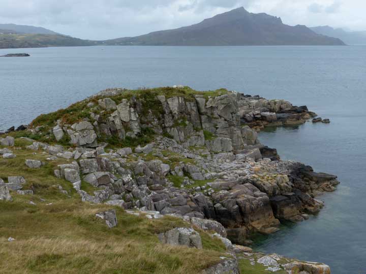
Dùn Grugaig, seen from the shore, amid wonderful rock architecture.

Dùn Grugaig atop its sheer sided promontory.

The entrance to Dùn Grugaig, seen on approach.

The beautifully built passageway into Dùn Grugaig.


This is the newly revealed 3rd stone of this circle, almost flush with the ground, and usually obscured by vegetation.

The 3rd circle stone, seen here to the right of the moss-encrusted ‘north’ stone.

A view of Crab’s Cairn through the newly opened up clearing through the surrounding gorse.


This is a composite of six photographs, taken at close range, showing the summit of Crab’s Cairn as viewed from the north.

This image of Lud Castle, taken across Castlesea Bay at low tide, emphasises just how naturally well defended this Pictish Fort was.

Although the entrance Arch to Gaylet Pot is well concealed, it is possible to obtain this oblique view of it by following a rough path down a steep grassy bank below the cliffs.

View over Dunnicaer Promontory Fort from the neighbouring clifftops.

Dunnicaer from the south showing the effects of centuries of erosion on its cliffs.


The impressive prow of Dunnicaer viewed from the beach.

The impressive Dunnicaer Sea Stac k, viewed from below the cliffs.


Archaeologists from Aberdeen University making the first exploratory dig on this Pictish fort.


The forbidding vertical cliffs inside Gaylet Pot.

The western shelf which gives the best views of Gaylet Pot.


A view of the Pot and entrance arch at Bullers of Buchan, from a neighbouring cliff top.

The magnificent arch that was once the gateway to the Bullers of Buchan cave (before it collapsed).

The collapsed cave, the Pot at Bullers of Buchan.


Drawings made during the excavation of D41 in 1809, photographed from the information board beside the monument


A view of hunebed D41 taken with an elevated camera.

Hunebed D41 stands opposite a housing complex, at the side of the Emmen-Odoorn highway.
The remains of Dunan an Aisilidh standing on top of a 15 metre crag at the tip of the Braes peninsula.

The probable entranceway into the dun.


Looking north over the ruins of Dunan an Aislidh and towards Beinn Tianavaig.

Panoramic view of Dunan an Aisilidh from the north.

The crag-girt eminence on which the remains of Dùn Cnoc a’Sga stand.

Dùn Cnoc a’Sga, topped by a modern cairn.


Remains of foundation walling to the northwest of Dùn Cnoc a’Sga.

Looking north over Loch Dunvegan from Dùn Cnoc a’Sga.

Tomnagorn as you never saw it before. With the woodland harvested, you can now obtain this fine view of the entire circle from a short distance up the hillside.

The grassy mound of Dunanellerich rises from right beside the roadside.

Stonework emerging from the sides of Dunanellerich.

Stonework protruding from the side of Dunanellerich.

Dun Treaslane, viewed from the north, with the River Treaslane to its right.

Remnants of foundation course walling at Dun Treaslane.

Dun Treaslane and the River Treaslane, looking north.