thelonious
Site record for Eigg, Struidh
Scheduled monument summary for Struidh, enclosure and underground chamber NE of Sron na h-Iolaire
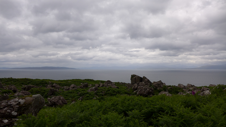
28/06/2016 – This site caught my eye when I was looking for places to visit on Eigg. Location looked great from the map and the Canmore classification of ‘Ritual Enclosure (prehistoric)’ sounded pretty intriguing. So on our first full day on Eigg, off we went to see if we could find it.
Two ways to this one, from the north or from the south – east is the sea and west are the cliffs of Beinn Bhuidhe. We walked in from the north. There is no path this way and at this time of year the bracken is bad. Easier from the south, access to the ground below the cliffs is at Bealach Clith. An OK-ish path heads north for a mile or so but then it’s again like from the north, just a case of bashing through the bracken. As you near the site, the whole place becomes one massive boulder field. You have to really watch your step. Finding the site proved tricky (even with GPS) as it’s in the middle of this boulder field. Some of the boulders are huge!
I didn’t know what to make of the enclosure surrounding the underground chamber really. Again the bracken didn’t help with trying to make out the structure (I’ll put a link to HES, which gives a full description, below and also Canmore which has some nice diagrams and photos)
The entrance to the underground void isn’t too bad but you have to watch your head on the roof. Inside the space is good and it extends a fair way. It’s a bit of a shock after a few hours of walking in the sunshine in an open landscape to suddenly be in darkness in such a small space relative to the outside world. After a while it felt peaceful and we both liked it very much. Lots of limpet shells on the floor near the entrance left by something or someone.
Overall I found the place a mystery and it was wonderful for that. Hard to get to and then find, especially at this time of year but if you are ever on Eigg it’s worth the trip, I’d love to read others’ thoughts on the place. Worth the walk just to be in such an amazing landscape for the day.


27/06/2016 – Morning ferry from Mallaig for a few days on Eigg. The highest place on the island is the magnificent pitchstone ridge of An Sgurr. As the ferry gets closer to Eigg it’s hard not to be totally captured by the hill’s ever increasing dominance of the surrounding landscape. The walk from the harbour is pretty straight forward. Just head west and then follow the red dots marking the way on the track leading to the hill. Approaching from the east, the sheer sides of the hill makes access seem a near impossible task but follow the track along the north side and about 500 meters west of the top a small gully allows access to the ridge. It’s then just a case of following the red dots to the top. Nothing too technical but a small word of caution, the three sides of An Sgurr are sheer and it wouldn’t be a great place to be in the wind and rain. I have no head for heights and did find the feeling of exposure a bit hard work. The views from the top are amazing. Rum, Skye and back to the mainland, very good indeed.
There is not much to see of a fort on the top though, just a dry stone wall running north-south near the access gully, that cuts off the eastern end from the rest of the ridge.
It’s possible to make the climb to the top and back to the ferry on a day trip but if you can it’s better to stay over a few days on wonderful Eigg and take the whole place in. The hill is a special one. It’s been 10 years since I was last on Eigg so it was great to finally make it back to visit this hill. Fantastic day.


30/05/2016 – Is this my favourite cup and ring marked rock? I think it just might be. I love the way the markings seem to flow down the rock from the natural shapes and grooves on top.


30/04/2016 – It was supposed to be a quick bob up Ros Castle and back on the way to Wooler but this area had other ideas for us. We started from the car park just past Hepburn. Short walk up the road and then a climb up to Ros Castle. The views from here were good. We had just driven down from Aberdeen in the morning and had made better time than I thought we would. A quick look at the map showed a hillfort, cup and ring marked rocks and a cairn to the south. With still plenty of day left, we left Ros Castle to take a look.
It’s a nice walk over Hepburn Moor to Blawearie Cairn. The cairn is very good. I can’t think of another like it that I have visited before. Great big stones surrounding a ring made of small stones (containing cists) with a small cairn of stones in the middle. The location is good and the whole site has a very peaceful feeling to it. I liked it very much.
We carried on to the excellent cup and ring marked stones and hillfort at Old Bewick.
On the way back we just had to visit this cairn again as the sun was still shinning and the stones did look good. Finally we left to head back to the car via the Hillfort at Hepburn Crags.
What should have been a half hour walk turned into a 10 mile plus day out with hillforts, cup and ring marked rocks and cairns in a wonderful landscape. I love days like this.


Nobody knows, nobody cares if I’m lonesome.
Nobody cries, nobody sighs if I’m blue.
It seems that night after night
I sit alone and twiddle my thumbs.
But still I keep right on hoping, keep the door open
But nobody comes.


01/05/2016 – In the end I gave up looking for this one and decided to make my way back to the path through the heather. Of course, as soon as I stopped looking the rock appeared at my feet. Sometimes you can try too hard, better just to let fate decide :-)
This was my favourite rock on the hill (which is covered in cup and ring marked stones). The rings are nice and dobby. It’s worth the effort and good fun trying to find.
01/05/2016 – I’d been looking forward to this one. A quick look at the map showed a hill jam packed with stuff – cup and ring marked rocks, hillforts, settlements and even a stone circle.
We started from Wooler. Walking over Weetwood Moor via the St Cuthbert Way (passing a few cairns on top) then crossing the Weetwood bridge to start the climb up Dod Law. Good paths all the way.
After reading the fieldnotes on here, I was a little worried that there wouldn’t be any stones still standing. Seemed like another one had fallen each time someone visited. Pleased to say that the one remaining upright stone is still hanging in there. I would loved to have seen this one complete. It’s a lovely little circle and a fine spot.
We left the circle behind to make our way uphill, looking for cup and ring and visiting the forts on top. Fantatsic hill.
Looped back to Wooler via the rock art stones on Weetwood Moor (great site). Good day out.


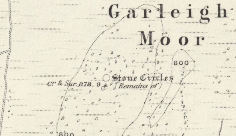
Old OS map (1866) has stone circles on the top. Anyone know anymore? Probably just the cairn?
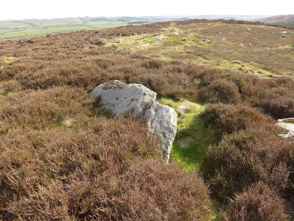
05/05/2016 – Standing inside Lordenshaws hillfort, just looking around at the view, I thought we were done for the day. Then I turned to face Garleigh Hill. The little white trigpoint seem to call out to me and the rocky side of the hill looked just to good to pass up on. Easy walk across and lots of interesting rocks to look at on the short climb up. The cairn is just next to the trigpoint. Large capstone visible. A fine way to end the day.
Old OS maps have stone circles marked on them at the top. I guess this is just the cairn. Anyone know anymore?


05/05/2016 – We parked at the Lordenshaws car park really just to have a walk on the Simonside Hills. Once there we realised that maybe we were heading in the wrong direction! The 1:50000 OS map doesn’t give that much away but a quick glance at the 1:25000 revealed a hillside full of megalithic wonder. Luckily we had all day so we chose Simonside first, leaving the afternoon free to roam the tops on the other side of the road.
The hillside, topped with a great hillfort, is just full of rocks with markings on the them. First up to the big one. Great rock art and the location is fantastic. Close views of the Simonside Hills and The Cheviots looking fine in the distance. After that we spent the rest of the time there just wandering around looking at random stones and taking in the scenery.
So much to see but the one that will stay with me is the Channel Rock. On the far side of the hillfort is this most fantastic rock. It’s huge and has this channel in it that has to be seen. I can’t really explain why I loved it so much but I just found the groove and the smooth surface of the rock so pleasing to the eye.
Top site. If you go (and you should) make a day of it. So much to see.


05/05/2016 – Nice walk over the Simonside Hills from Lordenshaws car park. I think I passed about 5 decent cairns on the way over. The one on Tosson Hill (highest top of Simonside Hills) is a good one. Great view north to The Cheviots.

05/05/2016 – I believe the large boulder on the right, towards the bottom is the one called Bob Pyle’s Studdie.


05/05/2016 – One of the four or five (I can’t remember which) large cairns that sit on the tops of Simonside.

08/05/2016 – Distant view of the circle from the track to the north. Even from here the circle was looking good with its possible outlier to the left.