
Southwest of Damme in the Clemens-August-Dorf north of the L846 on both sides of the branching K277 (to Ossenbeck) two passage graves are located: Damme 1 and Damme 2. You can use the car park of the cemetery Kommunaler Friedhof Neuenwalde to visit both sites. To visit Damme 1 you must walk about 550m from the car park, Damme 2 lies actually within the cemetry.
From the car park of the cemetry walk along the exit and you reach the road K277. Across the road a trail starts (look for a big sign) which brings you directly to the tomb.
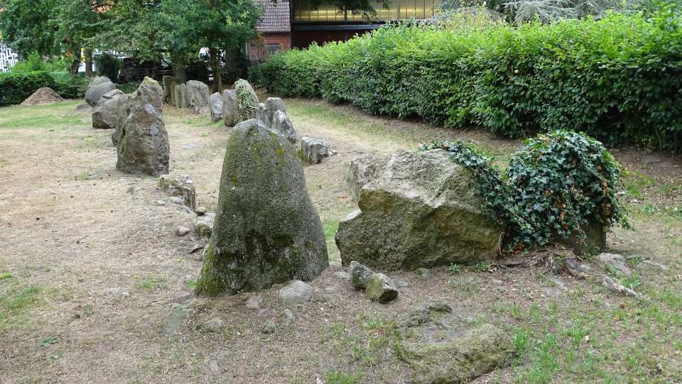
Damme 1 is a well preserved passage grave and worth seeing, magically surround by trees in a small clearing in the woods. The width is 3 meters in the middle, it tapers to 2.5 meters at the east end and 2 meters at the west end. All eleven supporting stones and four really impressive capstones are still present. Only one of the capstones has slipped into the chamber, the others are still lying on the support stones. On the south side a single stone probably marks the entrance.
Highly recommended, if you are in the area!
Visited July 2018

A first look at the tomb through the trees, the expectation rises and you know, you’re doing the right thing ;-)
Visited July 2018


Why was this sign screwed together with the stone?
Visited July 2018
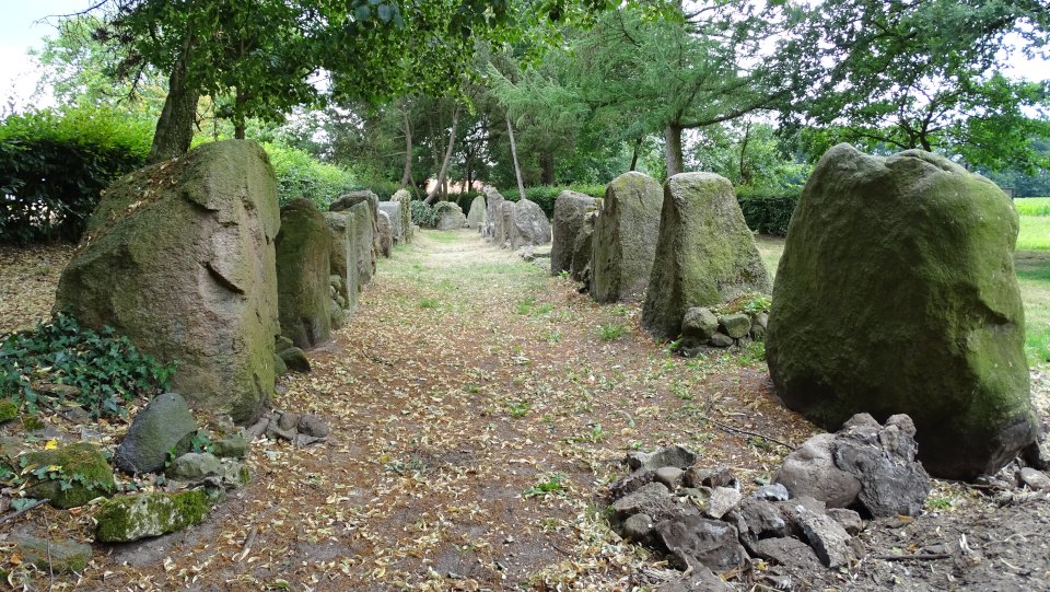
The gallery grave Wechte I lies south of the Bodelschwing church, a small unpaved road (An der Papiermühle) leads from the Brochterbecker Straße, where there is a sign, in about 60m directly to the tomb.
The tomb lies on a green meadow surrounded by hedges, behind some houses. The tomb is quite impressive (35 x 2.5m), according to the information board it was once at least 40m long (probably on the northeast side, as there is an end stone in the southwest section.
All in all a very nice tomb and due to the easy accessibility highly recommended, if you are in this part of the country.
Visited July 2018
Text taken from the information board:
Discovered by accident
During sand harvesting in 1928 a hitherto unknown megalithic grave was touched and then and dug out. At that time the approximately 2.5 m wide grave was still preserved on a length of about 35 m. Originally it must have been at least 40 meters long. The megalithic grave Langerich-Wechte I is one of the oldest and prehistoric relics of our region still visible in the area.
The formerly mounded burial chamber served in the period from 3400 to 2850 BC a rural community as a collective burial ground. It was built by the farmers, who were based in the Münsterland area. In addition to agriculture and livestock, hunting, fishing and gathering wild fruits and nuts supplemented the food supply. Settlements of this time are not yet known from the immediate vicinity of the megalithic grave, but in the area Heek, county Borken, remains of the then wooden houses were discovered.
At the time of the excavation, the stone-paved chamber floor was still intact. However, the larger granite and Osning sandstone blocks of the side walls and the ceiling had previously either pulled out or sunk deeper into the ground to allow for agricultural use of the area. Occasionally, dry masonry from flat rocks filled the up to 1 m wide gaps between the supporting stones. Access to the burial chamber could not be clearly determined during the archaeological examination, it was perhaps from a narrow side.
In addition to numerous human bones, the excavations revealed the remains of several hundred ornate pottery vessels of the funnel beaker culture, several flint and rock axes, weapons and tools made of flint and bone and jewelry made of amber, quartz, gagat and copper.
The site of Lengerich-Wechte is one of the most southerly examples of the megalithic tombs spread over the northern German-Scandinavian area.
After completion of the excavations 1928, the state was preserved and some of the remaining supporting stones set up again. In addition, some of the stones of a second destroyed megalithic tomb about 800 meters southwest were used for the reconstruction.
Visited July 2018


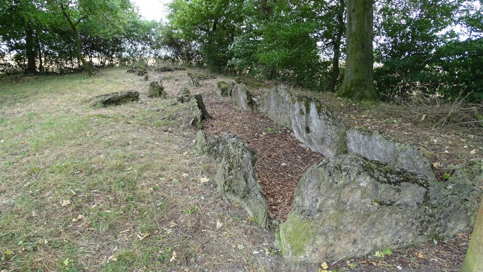
Hilter is located in a small park behind the town hall of Hilter, close to the road Zum Schoppenbusch.
The already completely destroyed grave was first discovered in 1902 and scientifically examinied. During the next years the exact location was unknown, that’s why it it took until 1982, when the grave was rediscovered. The excavation showed that the tomb was oriented east-west and trapezoidal. The length was 15 m, the width was between 2.7 m and 4 m.
The architecture of the tomb is quite unusual. Its walls consisted of boulders and dry stone masonry, as was the case with the northern megalithic tombs. Of these boulder eight were preserved. In the eastern part, however, was a transverse row of four broken limestone slabs, which divided the interior of the tomb into a pre- and main chamber. Such an architectural element is more typical of the gallery graves of the Hessian-Westphalian megalithic. The plant in Hilter thus represents a mixed or transitional form between the northern passage graves and the gallery graves further south.
After the last excavation the tomb was reconstructed about 300m away from its original location. Although the orientation and location of the entrance correspond to the original layout, the number and size of the stones in the reconstruction does not properly match the excavation findings and only a little amount of the original building material was reused.
Visited July 2018


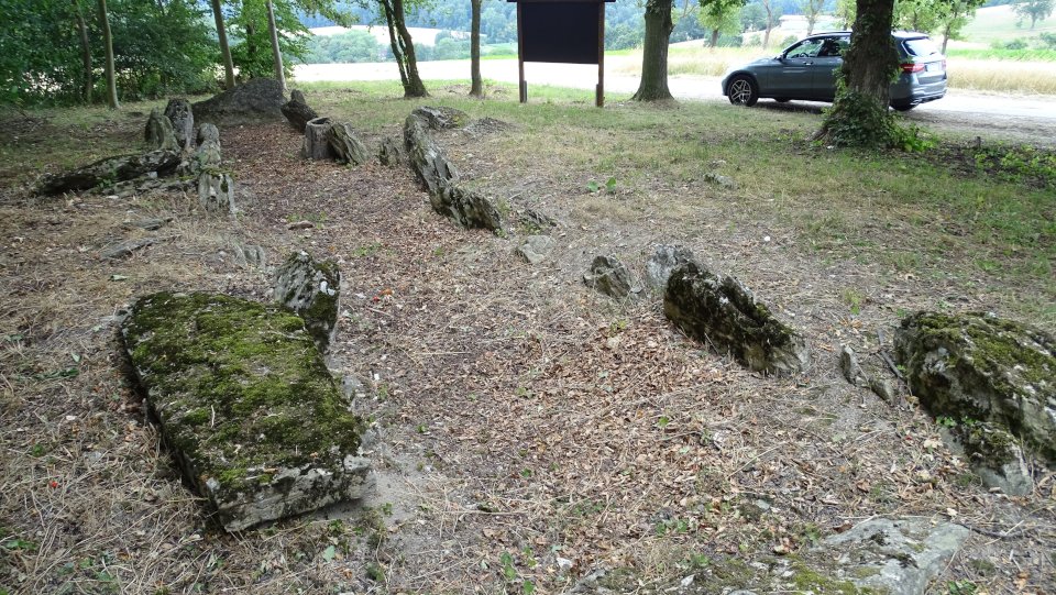
From the A33, take the Borchen exit south of Paderborn and drive towards Borchen. Now coming from the south, after about 400m you will reach a junction with the road An den Steinkisten. To get to the tomb turn right here and you’ll find the tomb after about 50m to your left. Kirchborchen I lies about 120m to the northwest.
Kirchenborch II is the better preserved tomb, at least you can recognize the shape and structure. The tomb it is about 15m long and 4m wide, inside the tomb two clusters of trees certainly contributed to the destruction of the tomb. According to the information board, there is a port-hole (“Seelenloch”) in the northeast, but it is hardly visible because a stone slab was laid in front of it.
Visited July 2018
Text taken from the information board:
Prehistoric Stone-chamber tomb Kirchborchen II.
This stone chamber tomb was built in the Neolithic period (about 2500-2000 BC) by the local rural population as a community grave.
The burial chamber was originally topped with stone slabs and covered by a mound (image). The access to the chamber was on the southeastern long side of the chamber. It had the form of an oval, out of two stone slabs worked out port-hole [in German “Seelenloch”].
As excavations have shown, several generations of dead were buried in such chambers by a clan or settlement community with their grave goods – food, drinks, jewelry, weapons and tools.
The impulses for the construction of the stone-chamber tombs of the “Hercynian type” came from southern and western Europe, especially the French Seine area, where there are numerous models of the same type.


Eingebrochene Decksteine = collapsed capstones
Findling = boulder
Rote Markierung: Rekonstruktion der südlichen Wand aus neuen Kalksteinblöcken (Bohrlöcher als Kennzeichen). = Red marks: Reconstruction of the southern wall with new limestone blocks (drill holes as mark).
Visited July 2018

Image 2 from the information board:
Vorraum = antechamber
Grabkammer = burial chamber
Türloch (“Seelenloch”) = hole in the door (“port-hole”)
Rekonstruktion des Steinkammergrabes = Reconstruction of the stone chamber tomb
Visited July 2018
From the A33, take the Borchen exit south of Paderborn and drive towards Borchen. Now coming from the south, after about 400m you will reach a junction with the road An den Steinkisten. To get to the tomb Kirchborchen I, turn left here. The road makes a right bend and about 75 meters later, as soon as the first houses appear on the right-hand side, the tomb is located about 30m to the right. Kirchborchen II lies about 120m to the southeast.
Unfortunately the tomb is heavily overgrown, only the last remaining capstone, which is collapsed into the tomb, is clearly visible. All other leftover stones, which are buried in the ground, can only be seen to some extent, which is a shame. So you have to rely on the information board and the drawings of the tomb to get an idea, how the tomb might have looked like. I read somewhere, that the chamber is orientated northeast-southwest and that it is about 21m long and 3m wide.
Visited July 2018
Text from the information board:
Cultural monument
Prehistoric Stone-chamber tomb
Kirchborchen I
This stone chamber tomb was built in the Neolithic period (about 2500-2000 BC) by the local rural population as a community grave.
The burial chamber was originally topped with stone slabs and covered by a mound (image 1 a-b). The access to the chamber was on the southeastern long side of the chamber. It had the form of an oval, out of two stone slabs worked out port-hole [in German “Seelenloch”] (image 2).
As excavations have shown, several generations of dead were buried in such chambers by a clan or settlement community with their grave goods – food, drinks, jewelry, weapons and tools.
The impulses for the construction of the stone-chamber tombs of the “Hercynian type” came from southern and western Europe, especially the French Seine area, where there are numerous examples of the same type.


Image 1a from the information board:
Tragesteine (Wand der Grabkammer) = supporting stones (wall of the burial chamber)
Eingebrochener Deckstein = collapsed capstone
Reste des Erdhügels = rest of the earthen mound
Visited July 2018

Image 1b from the information board:
Grabkammer = burial chamber
Türloch (“Seelenloch”) = hole in the door (“port-hole”)
Rekonstruktion des Steinkammergrabes = reconstruction of the stone chamber tomb
Visited July 2018

Image 2 from the display board:
The entrance to the burial chamber was discovered in 1976 during restoration work. It lies below the earth’s surface and it was not possible to preserve it visible due to the severely risk of weathering. The photo shows the “port-hole” carved on the edges by pick marks, seen from inside the chamber.
Visited July 2018
The gallery grave Etteln lies north west of the village on the Lechtenberg within a group of trees between fields. To reach the tomb turn left from the Kirchstraße (if you drive the K20 northward) into the Westernstraße, from here the tomb is signed (but a little unobtrusive). After about 750m turn right and after additional 750m turn left. You should reach a T-junction (you should already see the group of trees), turn right and after about 250m you should reach to tomb on your left. A pretty zigzag ride.
The place for the grave was probably chosen with great care more than 4.000 years ago, as it lies at the end of a ridge which slopes down to the north, giving very nice views of the landscape.
Visited July 2018
Taken from the information board:
Prehistoric gallery grave Etteln
Large community grave built in the Neolithic (2500 – 2000 BC.) in which a clan or settlement community of Neolithic cultivators buried for a long time their dead. Visible are the orthostats of the 22m long burial chamber, which are inclined inwards by the earth’s pressure.
The chamber formerly had a ceiling of large limestone slabs. It was sunk into the ground by two-thirds and covered by an elongated mound of earth.
On the south side, an entrance led into the now underground burial room.
Finds from the stone chamber graves are exhibited in the Westphalian State Museum of Prehistoric and Early History in Münster and in the local history museum of the Paderborn district, in the Wewelsburg.


Reconstruction of the uncovered gallery grave
Visited July 2018

Gallery grave seen from the south
Visited July 2018
Contains images where the tomb is actually visible ;-)
The grave is located at the northwestern end of Henglarn, just south of the road from Henglarn to the Autobahn junction Borchen-Etteln on the A33. It was discovered during the construction of the road. Unfortuantely it was heavily overgrown during my visit, without the display I would have probably passed the tomb without noticing.
The tomb’s chamber is about 18.5 meters long and about 2.5 m wide, it is oriented approximately Northwest-Southeast.
Visited July 2018