


Nesenitz is probably a grand dolmen with an enclosure. The current state of preservation is moderate to bad. The orientation and dimensions of the enclosure are no longer traceable today, since no enclosure stones are preserved. The chamber is west-east orientated, 1.9 m wide and at least 4 m long. Five supporting stones and two capstones are preserved.
You drive from Klötze in the direction of Bandau. Approximately 1.4 kilometers behind Klötze turn left towards Nesenitz. After 400 meters, the tomb is on the right of the road in a group of trees.
Visited March 2019
There used to be an exceptional stone on this megalithic tomb, the “Hexenstein” (“Witch stone”). The following legend has been handed down:
A beekeeper from Gladdenstedt wanted to bring his bees into the heath and had his boy with him to help him unload. When both came with their team to the witch stone, the horse was suddenly quiet and was unable to get out of the spot. When his father got off the carriage, to his astonishment, he saw that the horse was getting a foal. The boy was now also curious, got off the carriage and looked. At that moment, the horse struck and hit the boy so badly in the forehead that he fell dead to the ground on the spot. As a reminder, the father had the hoof of a horse and a foal and a cross cut in a large stone.
Alfred Pohlmann: Sagen aus der Altmark. Stendal 1901
Nettgau is a grand dolmen consisting of four pairs of supporting stones. The current state of preservation is good, a capstone has fallen down, fragments of one or two other capstones lie in or out of the chamber. The rectangular chamber is oriented east-east-west-southwest, 5.3 meters wide and 1.5 meters wide. All eleven support stones and three of formerly probably four capstones are preserved. The largest capstone measures 2.5 m x 1.9 m x 0.8 m. An enclosure was already in 1843 no longer available.
The tomb is located north of a large chipboard factory on a field, but there is no way through the field, you should visit the tomb only after harvesting or before sowing. Drive from Nettgau on the K1127 towards Mellin. About 900 m after Nettgau, turn left on a side street in a northwesterly direction. Follow this road for approximately 1.8 km and pass the factory to your left until the factory site is over and a dirt road turns left. Either park your car here and drive on (not allowed) for 400 m. The tomb is under a group of trees in the field to your left.
Visited March 2019


Lüdelsen 6 is a passage grave consisting of seven pairs of supporting stones and a trapezoidal, in the middle narrower enclosure. The current state of preservation is very good, only a few enclosure stones are fallen over. A stone on the eastern narrow side is no longer fixed, another is missing, as is a support stone. The entrance is not clearly recognizable, because some stones are missing or shifted. The enclosure is east-west orientated and about 35 m long and 5.2 – 8.5 m wide. Fifty of a total of sixty enclosure stones are preserved, almost all of them are exceptionally large. Three of the four cornerstones (“Guardians”) and five other surrounding stones have been fallen over. The rectangular chamber is east-west orientated, 7.9 m long, 1.7 m wide, 1.1 m high and lies in the western end of the enclosure. Fifteen from formerly sixteen support stones and all five capstones are preserved, the biggest capstones measures 2.2 m x 1.9 m x 0.8 m.
You drive from the parking lot at the tombs Lüdelsen 1 to 5 in the direction of Lüdelsen. After about 650 meters there is a small sign with the inscription “Großsteingrab” on the street. Park your car here and follow the north-facing forest path 350 meters to an information board on the nature trail. There, turn left into the path and then reach the complex after about 170 meters.
The site, popularly known as the King’s grave, is one of the largest and best preserved megalithic tombs in the Altmark region. Highly recommended!
Visited March 2019
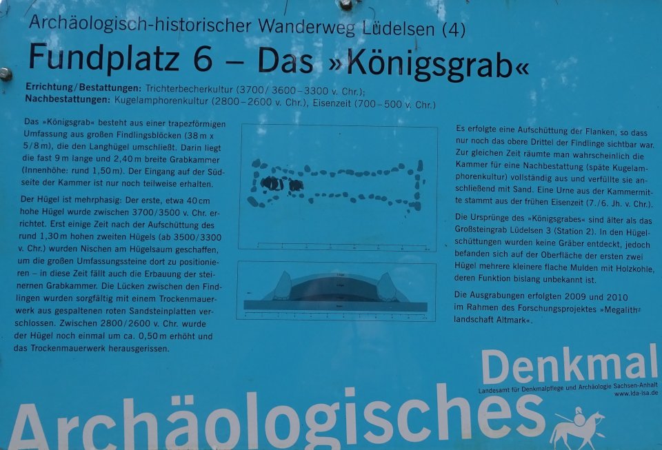
taken from the “Archäologisch-historischer Wanderweg Lüdelsen (4)” information board:
Site 6 – The King’s Grave
Construction/Burials: Funnel Beaker Culture (around 3700/3600-3300 BC);
Secondary burials: Globular Amphora culture (2800-2600 BC), Iron Age (700-500 BC)
The “King’s Grave” consists of a trapezoidal enclosure of large boulder blocks (38 m x 5-8 m), which surrounds the long hill. Therein lies the almost 9 m long and 2.40 m wide burial chamber (internal height: around 1.50 m). The entrance on the south side of the chamber is only partially preserved.
The mound is multi-phase: The first, about 40 cm high mound was built between 3700-3500 BC. Only some time after the embedding of the approximately 1.30 m high second mound (from 3500-3300 BC) niches were created on the hilltop to position the large enclosre stones there – in this time also the edification of the stone burial chamber. The gaps between the boulders were carefully closed with a dry masonry of split red sandstone slabs. Between 2800-2600 BC the mound was again increased by about 0.50 m and the dry masonry was torn out.
After that the flanks were raised, so that only the upper third of the boulders was visible. At the same time, the chamber for post-burial (late Globular Amphora culture) was probably completely cleared and then filled with sand. An urn from the middle of the chamber dates from the early Iron Age (7th – 6th century BC).
The origins of the “King’s Grave” are older than the megalithic tomb Lüdelsen 3 (Station 2). No tombs were discovered in the mounds, but on the surface of the first two mounds were several smaller shallow depressions of charcoal, the function of which is unknown.
The excavations were carried out in 2009 and 2010 as part of the research project “Megalithic Landscape Altmark”.

From the southeast end towards the chamber in the west
Visited March 2019

From the southeast end towards the chamber in the west
Visited March 2019

From the northeast end towards the chamber in the west
Visited March 2019

The chamber in the western end of the Hunebed
Visited March 2019

The chamber in the western end of the Hunebed
Visited March 2019

From the northwest end towards the east end of the Hunebed
Visited March 2019

From the northwest end towards the east end of the Hunebed
Visited March 2019

Panorama shot from the southwestern end of the Hunebed towards east
Visited March 2019

Panorama shot from the southwest
Visited March 2019

Lüdelsen 5 is a grand dolmen consisting of three pairs of supporting stones. The current state of preservation is moderate, one support and two capstones are missing, the mound is nearly eroded. The capstone is sunken and lies lengthwise on the chamber. A nearby stone could belong to a formerly existing enclosure. The rectangular chamber is northwest-southeast orientated, about 2.5 m long and 1.4 m wide. Six of the former eight support stones and one of probably two capstones are present. The remaining capstone measures about 2.2 m x 1.5 m x 0.8 m.
To get to the tomb Lüdelsen 5, go from the parking lot on a forest path, which is located opposite of Lüdelsen 3, back east towards Stöckheim. After about 30 meters you pass Lüdelsen 4 and after another 50 meters you reach the tomb.
Visited March 2019
Lüdelsen 4 is a grand dolmen consisting of three pairs of supporting stones. The current state of preservation is moderate, one support and two capstones are missing, the preserved capstone has sunken. Neither an enclosure nor a mound are recognizable. The chamber is east-west orientated, about 3.3 m long and 1.4 m wide. Seven of the former eight support stones and one of probably three capstones are present. The remaining capstone measures about 1.8 m x 1.1 m.
To get to the tomb Lüdelsen 4, go from the parking lot on a forest path, which is located opposite of Lüdelsen 3, back east towards Stöckheim. After about 30 meters you will reach the tomb.
Visited March 2019
Lüdelsen 3 is a grand dolmen and is located on a southern slope. Before the excavations began, only two capstones and two supporting stones as well as a mound of about 10 m diameter were visible. The tomb is oriented west-northwest-east-southeast.
The excavation revealed that the mound was built in two phases. The diameter of the second, larger mound could be determined to be about 30 m. Likewise, it was possible to identify two enclosures that consist of at least two circles of stones. The inner one could be clearly reconstructed. It consists of 10-40 cm field stones, which were placed in two to three layers on top of each other. The inner mound ends at the first enclosure. An outer row of larger stones is only partially preserved. Their original form is unclear.
In the area of the chamber more supporting stones came to light during the excavation. The chamber measures 4.2 m by 2.6 m on the outside and consists of seven supporting stones on which two capstones rest. Two additional support stones in the east form the entrance, which bends to the north.
The tomb lies only 40 meters north from the parking lot, left of the forest path.
Visited March 2019
taken from the “Archäologisch-historischer Wanderweg Lüdelsen (2)” information board:
Megalithic tomb Lüdelsen site 3
Construction: Funnel Beaker Culture (around 3550 BC);
Burials: Funnel Beaker Culture 3550-3200 BC;
Secondary burials: Single-Grave culture (2400 BC)
The construction of this site with burial chamber, a double or three-row stone embankment and the first mound was around 3550 BC. The chamber construction (inner height approx. 1.0 m) consisted of two capstones, seven support stones for the actual burial chamber and two more for the entrance. The gaps between the stones were filled with split wedge-shaped granite stones (dry-stone walling). The outer joints were carefully closed with 2-5 cm, smashed flint fragments. The larger splinters between chamber and entrance stones filled the builders with simple field stones. The two stone enclosures, built at the same time, formed with the entrance stones a court in front of the chamber, delimited to the outside by a freestanding menhir. The inner stone encirlce formed the boundary of the first, older mound. It reached to the lower edge of the capstones, which remained uncovered and visible. Finds (broken pieces and a cross-cutting arrowhead) from the non-paved chamber floor are from the first burials (Funnel Beaker Culture). The last funeral took place around 2400 BC (Single-Grave culture). In this context, a second mound of almost 30 m in diameter was built up, which completely covered the first mound and both stone enclosures. The capstones, however, were still visible. Since that time the chamber remained undisturbed. Findings from the area around the tomb prove that the people visited the site in the Bronze and Iron Age again and again.
After the complete excavation in 2007, the megalithic grave was rebuilt in 2008 on the basis of the excavation plans.
Lüdelsen 2 is a grand dolmen consisting of three pairs of supporting stones and an oval enclosure. The current state of preservation is moderate, due to destruction during the road building numerous supporting and enclosure stones are missing or are fallen over. The capstones have sunk into the chamber and broken. The chamber is east-west orientated, the length is not reconstructable, width 8.5 m. From the enclosure eleven stones are preserved.
The tomb is opposite the parking lot in close proximity to the road.
Visited March 2019

site plan taken from Landesamt für Denkmalpflege und Archäologie
(State Office for Preservation and Archeology)

site plan taken from Landesamt für Denkmalpflege und Archäologie
(State Office for Preservation and Archeology)
Lüdelsen 1 is one of the most southerly and the only polygonal grand dolmen that still exists today in Saxony-Anhalt. A Polygonal dolmen is a subspecies of the dolmen, which can be found especially in the north of the Danish island Seeland, in the Swedish province of Bohuslän, on the Kimbrian peninsula (eg Troldkirken in Jutland) and in Schleswig-Holstein (11 preseved tombs).
The current state of preservation is good, the edges of the hill are plowed, giving it a pointed-oval shape. An enclosure (Hunebed) probably has never existed. The chamber is northwest-southeast orientated and measures 2.5 m × 1.2 m with a visible height of 0.6 m. The size of the capstone is 2.9 m × 2.2 m × 1.0 m. On the capstone, which shape is responsible for the arrangement of the support stones, there are many small cup marks.
To get to the tomb Lüdelsen 1, go from the parking lot on a forest path, which is located opposite of Lüdelsen 3, back east towards Stöckheim. After about 30 meters you pass Lüdelsen 4 and after another 50 meters Lüdelsen 5. Lüdelsen 1 is then about 70 meters further, already in the field, on a small mound under a group of trees.
Visited March 2019


Translation for text on sign:
Probably destroyed passage grave; six supporting stones mark in the northern section a preserved part of the tomb; a larger capstone overlays the burial chamber; on the north side of the burial chamber, the right side stone of the entrance to the tomb is recognizable, through this entrance the burials are formerly made; all stones of the southern section have been removed, the burial mound is still recognizable
Visited March 2019


