


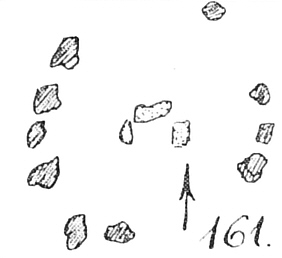
site plan according to Krause / Schoetensack 1893
Visited April 2019
About 30 meters further southwest of Tangeln 4 lie some stones, which could be the remains of a megalithic tomb that may have been mentioned e.g. by Krause / Schoetensack. Above ground 4 stones are still preserved, which however no longer show any structure of the tomb. It might be the remains of Tangel 2 or 3, since there were probably in this area.
Park at the (private) entranceway of Schloss Neumühle. A forest road starts left of the access. Follow the road slightly uphill for about 500 m. At the highest point, a path turns southwest sharply to the right. Follow this path, after 400 m the tomb lies about 40 m in the forest.
Visited April 2019


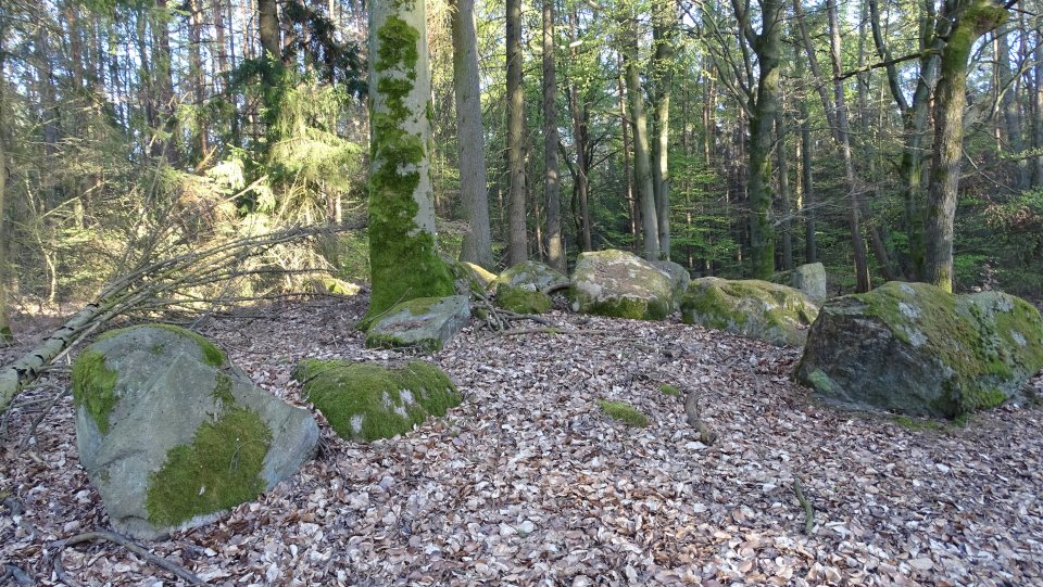
The tomb is badly damaged and can no longer be assigned to a type. The still recognizable, eroded burial mound has a diameter of 14 meters and is about 0.5 m high. Two support stones and one capstone are still present. An enclosure is not recognizable.
Park at the (private) entranceway of Schloss Neumühle. A forest road starts left of the access. Follow the road slightly uphill for about 500 m. At the highest point, a path turns southwest sharply to the right. Follow this path, after 400 m the tomb lies about 40 m in the forest.
Visited April 2019


Tangeln 5 is a grand dolmen consisting of seven (?) pairs of supporting stones and likely an enclosure. The current state of preservation is moderate. All capstones are sunken, the wall stones tilted, pushed apart and therefore not all assignable. Enclosure stones are scattered. An enclosure was probably present, but the form can not be reconstructed. A maximum of four or five enclosure stones are preserved. The northwest-southeast oriented burial chamber was probably rectangular and measures 11.5 meters long and 4 meters wide. About 16 wall stones and at least five capstones are preserved.
Park at the (private) entranceway of Schloss Neumühle. A forest road starts left of the access. Follow the road slightly uphill for about 500 m. At the highest point, a path turns southwest sharply to the right. Follow this path, after 400 m you pass Tangeln 4 and 150 m further on there is the turnoff to the tomb.
Visited April 2019


site plan according to Krause / Schoetensack 1893
Visited April 2019
Another still unnumbered tomb was discovered in 2006 after hints from inhabitants. It is 800 meters southeast of Mellin and 700 meters south-southwest of Tangeln 5.
Most of the stones are said to have been taken away in the 1920s. The destruction is too strong to be associated with a particular type of tomb. The current state of preservation is very poor, only a few stones are still existing. A mound is missing because the tomb had been incorporated into a natural hill. A grave border can not be identified. The burial chamber is oriented east-west. Three wall stones and a capstone have been preserved above ground. The chamber is rectangular, 3.6 meters long and 2.3 meters wide.
To find this tomb, it is recommended to use a GPS device. Park at the (private) entranceway of Schloss Neumühle. A forest road starts left of the access. Follow the road slightly uphill for about 500 m. At the highest point, a path turns southwest sharply to the right. Follow this path, after 400 m you pass Tangeln 4 and 150 m further on Tangeln 5. 150 m after the turnoff to Tangeln 5 (that means 700 m after the sharp turn), another path turns off in a more southerly direction. Follow this path for about 570 m (last 50 m downhill) until you came to a T-junction. Turn right here further downhill and follow the narrow pass for about 70 m and look for a trail that leads up the left slope. Follow the trail and you should reach the tomb lies after about 100 m.
Visited April 2019


From the original site today only the burial mound and a wall stone of the burial chamber are preserved. It seems that at least until the 1960s, more stones were available. The burial mound can still be seen very well, but unfortunately it was completely ploughed up to remove the stones. It is oriented east-west and of oval shape. It has a length of approx. 16 m, a width of 12 m and a height of 0.9 m. The wall stone measures 1.3 m × 1.2 m. It is reddish and has a smooth inside.
There seems to be an easier access route than I chose for my visit, as I parked at the (private) entranceway to Schloss Neumühle and walked about 3km via Tangeln 6 from there.
Drive, just like for Tangeln 6, from Immekath to Ristedt and turn there to Neu Ristedt. At the end of the village, the road turns into a dirt road, which continues to the forest. Since this road seems to be an official road, follow it to a star-shaped crossing (six-arm). There you turn off the car and turn in the sharp left to the main turning. After 380 meters the path makes a slight bend to the left. From here you could get to the grave cross-country or on smaller forest roads using a navigation device. Otherwise, follow the main road for another 730 meters to a major crossing road. Turn right and follow it for about 700 meters to a smaller, right-turning path. There you turn off and follow this path for 100 meters, until the left side of the trail you can still see the clearly visible mound.
Visited April 2019


Tangeln 6 is a grand dolmen consisting of four pairs of supporting stones and likely a rectangular or oval enclosure. The current state of preservation is very good. Almost all stones are still present, but partly heavily covered with moss; few enclosure stones have been overturned. The enclosure as well as the chamber are northwest-southeast oriented. The enclosure measures 23.6 m x 5.2 m (in the northern part) to 6.4 m (in the southern part). Thirty-two of formerly thirty-eight enclosure stones are visible. Probably outside the enclosure, before the southeastern end, stood two now overturned guardian stones. The chamber meassures 5 m x 1.5-1.8 m and lies in the northwest part of the enclosure. All ten wall stones and four capstones are preserved, two capstone are sunk and completely overgrown, as well as most of the wall stones. Unfortunately, the vegetation continues to spread in the tomb, making it increasingly difficult to identify the entire structure.
There seems to be an easier access route than I chose for my visit, as I parked at the (private) entranceway to Schloss Neumühle and walked about 2km from there.
Drive from Immekath to Ristedt and turn there to Neu Ristedt. At the end of the village, the road turns into a dirt road, which continues to the forest. Since this road seems to be an official road, follow it to a star-shaped crossing (six-arm). There you turn off the car and go straight ahead to the 2nd junction. Here you turn left. After another 300 meters you should see the mound of the tomb on your left, which is located 60 meters from the path in the forest.
Visited April 2019


The enclosure in the southeast part
Visited April 2019


site plan according to Krause / Schoetensack 1893
Visited April 2019
The current state of preservation of Tangeln 1 is bad, therefore the grave type is no longer recognizable. No capstones are preserved or visible, enclosure stones are only partially preserved and in the middle the tomb was gutted and the chamber destroyed. The enclosure as well as the chamber are probable north-south oriented. The enclosure measures 20 m long and 8.5 m wide, the length of the chamber is no longer recognizable, the width is 1.4 m. The mound is clearly visible from the path, about 20.5 m long, 11.3 m wide and 0.6 – 0.8 m high.
Since Tangeln 1 is about 100 meters north of Tangeln 7, the same directions apply.
Drive from Tangeln on the K1396 towards Mellin. Just before the road turns onto the B45, the road makes a sharp right-hand bend. Here one drives straight out and parks the car directly on the right side, since a private road begins here. Walk, after about 60 m a path leads to the left. Follow this path, which first goes in a southern direction, before it turns after 100 m to northeast to lead around a field. After another 100 m the path turns to a southeast direction and leads in 350m first to the edge of a forest before it turn in a southern direction. After 120 m Tangeln 1 lies about 60 m to the left.
Visited April 2019


site plan according to Krause / Schoetensack 1893
Visited April 2019