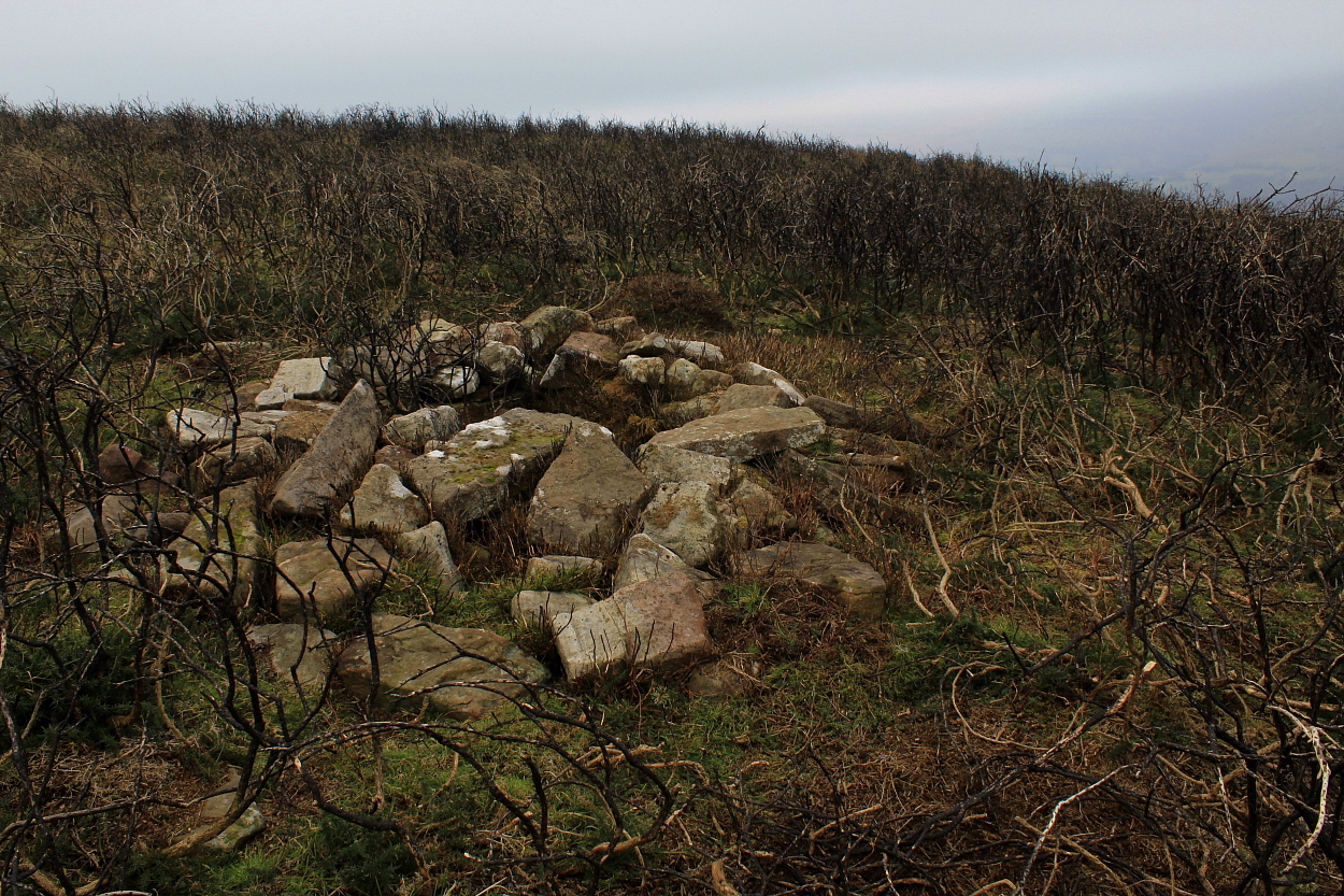
Located within sight of the nearby stone row, this well-preserved cist - like its neighbour - is not marked upon current OS mapping... forming but one of the Cwmdeuddwr Hill's many, many prehistoric gems just waiting to be discovered.
|
Two Bronze Age cairns standing overlooking Cwrt-y-Cadno (The Fox Court) upon the south-western flanks of Mynydd Mallaen. A good excuse to lose yourself (not literally, one would hope) for several hours upon these hills. The southern monument remains pretty substantial, the northern rather 'lower', yet still retaining a significant diameter. Both cairns feature a prominent 'slab' which may, or may not have formally been part of a cist or chamber. Who knows?
Nowadays, this part of Mid Wales is a haven of tranquillity... however, this wasn't always the case. The Romans - yeah, them - came to mine gold, the remains of their aqueducts apparently still visible if you know where to look (The Citizen Cairn did not). Later on, Cwrt-y-Cadno was a noted 'stop-over' point for drovers taking their cattle all the way to London. Times change, eh?
Coflein notes:
"Remains of two burial mounds, situated in enclosed pasture. The northernmost cairn (Item A: SN69594299) measures about 14m in diameter and up to 0.6m in height". [Source: Cadw Scheduling Description. FF 04.01.2005]
|
Not marked upon current OS mapping, this is nevertheless well worth the dedicated Citizen Cairn seeking out. Located - as the professionals' prosaic name makes clear - overlooking the Afon Prysor upon the uncompromising Migneint, my route, initially following the nearby Nant Gefail-y-miners from the B4391 was, to say the least, heavy going.
Coflein reckons:
"Remains of a burial cairn, probably dating to the Bronze Age, and situated within open moorland on an outcropping ridge above Afon Prysor. The stone built cairn is circular on plan and measures about 6m in diameter and up to 0.5m in height. Several definite kerbstones are visible. The cairn has been deliberately positioned below the summit of the ridge on a slight terrace but set back from the leading edge". [Source: Cadw scheduling description. 11/08/2004 FF]
|
This is by far the most significant of a small cemetery of cairns located below, and a little to the south, of the great summit cairn of Craig Twrch... the well-preserved cist found to be still in situ makes a pause here imperative.
|
Millpond Wood is a veritable oasis of calm and greenery - assuming you discount the noisy japes of a couple of lads playing football in a nearby back garden - set between the Sevenoaks suburbs of St Johns, Seal and, appropriately enough, Wildernesse. Yeah, surrounded by housing estates as this woodland is, arguably the last thing one would expect to encounter would be a great round barrow upon its eastern fringes... and a pretty odd one at that, having been the depository for copious Mesolithic 'artefacts'.
I approached via Pinewood Avenue - having made sure I wouldn't annoy any locals with my finely honed lack of parking prowess - turning left, then left again as I entered the sanctuary of the canopy. Despite being bisected by a wide path, not to mention acting as the depository for some idiot's grass cuttings, the barrow remains a substantial, upstanding monument. A rather idyllic setting, if the truth be told, particularly smothered with quite outstanding early May bluebells.
Furthermore, numerous locals out and about couldn't have been more friendly, even a bloke who looked and sounded like Bez's best mate. Well, all except one miserable old bat who objected about something or other - no idea what. But hey, there's always one, isn't there?
|
       
|
I found this to be a rather sad place for those with a semblance of an inquiring mind - inhabited by locals with (apparently) no knowledge of what lies within their midst - if only to judge by a guy walking his dog within the fenceline (He: 'Sorry, there's no hillfort here'; Me: Err.. apart from that great big earthen bank beside you, you mean?) and several similarly bemused passers-by. All very nice, friendly people, but... the mind does boggle, as they say.
So antiquarians be warned: the interior has been transformed into an orchard/Scout Camp, meaning there's no 'reasonable' access without having the (apparently) belligerent landowner upon your case. Incidentally, I do hope said landowner does not dwell within the house at the bottom of Beresford Hill to the east, however, since damaging a scheduled ancient monument by erecting wooden structures upon it is obviously a criminal offence. Unlike trespass. Whatever, it's such a shame to waste our precious heritage upon people with no concept of what it represents, but hey.
Nonetheless, worth a look from the environs in passing - I had an hour or so to spare - since there remains some pretty hefty earthworks here.
|
   
|
|
    
|
       
|
Located upon the wondrous Ketty Ridge between - significantly, perhaps? - the sources of the Severn tributary Afon Miwl (River Mule) and Afon Tefeidiad (River Teme), these are two pretty substantial round barrows, albeit sadly isolated from the track by barbed wire Why, oh why do they do this? I was able to cross over without any damage/incident, but please bear this in mind.
Coflein reckons:
SO1177085090: "...24m in diameter and 1.0m high, an excavation trench of 1912, which produced a cinerary urn and details of mound construction, is still apparent."
SO1167085040: "... 24.5m in diameter and 1.7m high, excavated in 1926 producing numerous flints, an inhumation and three cremation burials."
[J.Wiles 28.08.02]
|
OK, not the most upstanding fort you'll ever see, having been much impacted over the years by gravel workings... however, well worth stopping off for a visit, seeing as this is a fine corner of Essex.
In summary, Historic England reckons:
"A slight univallate hillfort which lies roughly in the centre of the Dengie peninsular, on a plateau rather than a hilltop. The defences include a bank and external ditch, which as visible on the east & south of the enclosure as earthworks. Bronze Age and Iron Age. There is conjectural evidence (through finds) for reoccupation in the Roman period and in the early Anglo-Saxon period."
|
Well seen - assuming one knows what it represents - from the fantastic drystone ramparts of Foel Faner, this small promontory fort is not recorded by either OS or Coflein; however GAT (PRN 19655) have this to say:
"A small rounded hillock forming a promontory has a grassed-over bank along the neck of the promontory. The bank is still steep on the outside, partly degraded by stock trampling in the past but now stable. It is c.3m wide and up to 1m high on the inner side. There is no external ditch but there is an internal quarry ditch most clear at the east about 3m wide. There is no obvious entrance. Parts of the rest of the hillock are naturally sheer but at the S has relatively accessible slopes although there is no evidence of a bank there. The earthworks are clearly visible from Moel Faner and it is surprising that neither Gresham or the OS noticed them. The ramparts appear to be earthworks rather than walls. There are no signs of internal huts or platforms. (Smith, 2006)"
|
|
      
|
Driving north upon Seale Road, the traveller intent upon ascending Long Hill is alerted to the existence of this barrow cemetery - actually a rare 'triple bell barrow' (the only other example I can recall being the Advent Triple Barrow upon Bodmin Moor) - by the access drive to 'Three Barrows Place' to his/her left. Ask here if, like The Citizen Cairn, you'd much rather spread harmony than discord... since, in retrospect, methinks the multiple monument sits upon private land.
Although heavily overgrown, clearly this was - hey, still remains - a well-preserved, impressive site. Historic England has this to say:
"The monument includes a triple bell barrow situated on a low ridge in the Lower Greensand. It comprises three mounds in a slightly offset line running NNW-SSE and surrounded by a single ditch and outer bank. The northern mound is 10m in diameter and 0.8m high, the middle mound 16m in diameter and 1.8m high and the southern mound is 13m in diameter and 1m high. There is a hollow in the top of the central mound suggesting that it was once partially excavated. Around the mounds is a level platform, or berm, which is contained by a single ditch. This has become partially infilled over the years, the majority of it surviving as a buried feature; however, it can still be seen at ground level on the eastern side of the monument where it survives to 3m wide and 0.3m deep. Beyond the ditch are the remains of an outer bank 4.5-5m wide and 0.2m high which is also best preserved on the eastern side of the monument."
Note that the two bowl barrows upon Long Hill to the approx northwest are pretty substantial... so you'll want to see them, too. It'd be rude not to, while you're here.
|
There are actually two bowl barrows here upon Long Hill (Crooksbury Hill is some way to the approx northwest): that to the northwest, substantial and reasonably well preserved; its companion to the south-east is a little less upstanding but still pretty voluminous. One assumes Rhiannon is referring to the excellent triple bell barrow upon Turners Hill located within woodland to the approx southeast? The siting and vibe are excellent, with sweeping views across Crooksbury Common to the south.
Historic England has the following to say:
"The monument includes two bowl barrows, aligned north-west to south-east, situated on a south-facing rise on the Lower Greensand. The northern barrow comprises a mound 22m in diameter and 2m high with a surrounding ditch from which material was quarried during the construction of the monument. This is no longer visible at ground level, having become infilled over the years, but survives as a buried feature c.3m wide. The second barrow, less than 20m to the south-east, has a mound 16m in diameter and 1.1m high with a slight central hollow suggesting that the barrow was once partially excavated. This too is surrounded by a quarry ditch which survives as a buried feature c.2.5m wide."
Access to the common is via an off-road parking area from Seale Road. Follow the track heading to your left, prior to veering uphill to the right.
|
Hi, I'm Robert ... with a passion for attempting to understand the lives of the pioneering prehistoric inhabitants of these British Isles, seeking out the remains they left behind in order to ask myself "why here ... why did it matter so... why such commitment?".. Needless to say, I'm still pondering such intangibles. Just as an empty house appears to retain echoes of past humanity... so does the stone circle, the chambered cairn, the long barrow and the mountain top funerary cairn. Visiting them, I think, helps engender a certain 'connection' with this land of ours, with ourselves - our past, our present and our future; a reference point for those of us perhaps struggling to make sense of this so-called 'computer world' Kraftwerk warned us was a'coming in 1981.... danke, mein herren.
In the unlikely event my posts provide inspiration for others to venture into the Great Outdoors, please bear in mind the hills and mountains of these Isles are unpredictable, potentially dangerous places. You are a fool if you do not suss out what you are letting yourself in for and ensure you have map/compass/waterproofs... and learn how to use them. Weather conditions can change bewilderingly quickly - even in high summer - so don't get caught out. Please engage with landowners wherever possible... being a cartoon 'class warrior' might be jolly good fun for the ignorant communist 'rebel'... but not for those who follow in their footsteps.
George Orwell - 'The essence of being human is that one does not seek perfection.'
Martin Gore - 'Like a pawn
On the eternal board
Who’s never quite sure
What he’s moved towards
I walk blindly on'...
Truman Capote - 'Failure is the condiment that gives success its flavour.'
Oscar Wilde - 'The true mystery of the world is the visible, not the invisible.'
John Lydon - 'It is a reward to be chastised by the ignorant.'
Winston Churchill - '“The farther backward you can look, the farther forward you are likely to see.”
Ultravox - 'Taking shelter by the standing stones
Miles from all that moves....'
Catch site videos from the Citizen Cairn at: https://www.youtube.com/channel/UCFk6mRD0QCGTnUXRBlSJ44w
|
|