

I found this to be a rather sad place for those with a semblance of an inquiring mind – inhabited by locals with (apparently) no knowledge of what lies within their midst – if only to judge by a guy walking his dog within the fenceline (He: ‘Sorry, there’s no hillfort here’; Me: ‘Err.. apart from that great big earthen bank beside you?) and several similarly bemused passers-by. All very nice, friendly people, but...
So antiquarians be warned: the interior has been transformed into an orchard/Scout Camp, meaning there’s no ‘reasonable’ access without having the (apparently, or so I was informed) ‘belligerent landowner’ upon your case. Incidentally, I did wonder whether said ‘belligerent landowner’ dwells within the house at the bottom of Beresford Hill, to the east. I did consider enquiring, since I would have been in a good mind to demand any member of the constabulary subsequently summoned would investigate the damaging of a scheduled ancient monument by the erection of wooden structures upon it... which, unlike trespass, IS a criminal offence. But, as I said, it would appear no-one gives a damn here.
Nonetheless, worth a look from the environs in passing – I had an hour or so to spare – since there remains some pretty hefty earthworks here.

From the east. Isn’t it curious – if not criminal – how the owner of the house to the right was somehow allowed to erect a wooden deck upon a scheduled ancient monument?

Western bank

The most substantial remaining length of defences from Berefords Hill to the east. Again, this is as close as I could get without having the local constabulary called.

Looking across the ploughed out – or never completed... surely not? – southern flank to the western.

The clearly quite substantial western flank from the south. Unfortunately, this was as close as I could get... despite engaging over the fence with a local who suddenly appeared walking his dog to the monument’s left a minute or so later. Suffice to say, said individual had no idea what occupied the field beside him...


The celebrated – I have to say, justifiably so – sandstone crags so beloved by visitors over the centuries form the north-western flank of the hillfort.
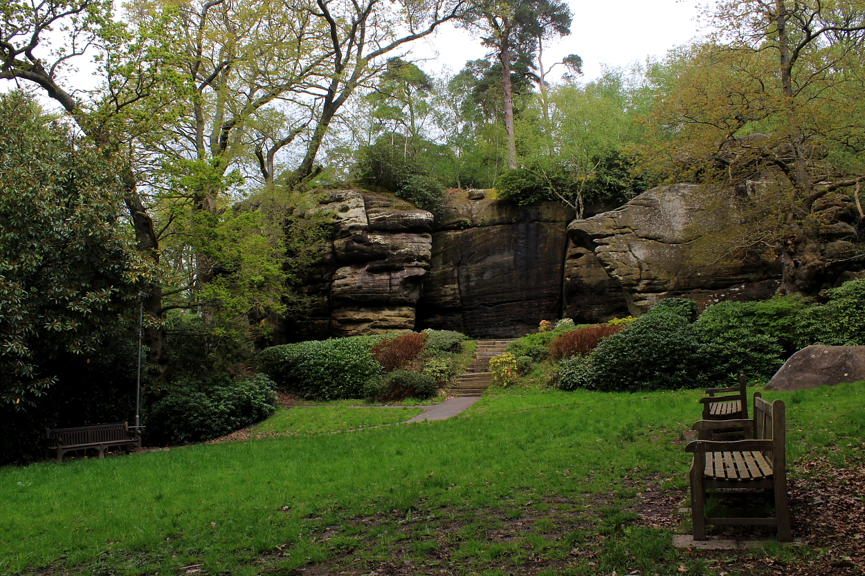
The approach from the hotel... Mesolithic rock shelters topped by the remains of a hillfort? That’ll do.


I had put off coming here for years, wary of the whole twee ‘bride and groom posing upon a craggy rock like elitist Victorians-vibe’. However, once through the turnstile, this is actually a pretty impressive prehistoric site.

Pretty much how one might suppose a Mesolithic cave settlement to be, to be fair?

In addition to the obvious overhangs, the sandstone crags are riven with deep fissures providing a lot of scope for high-end Mesolithic camping. The wooden bridge forms part of the elevated walkway allowing punters to traverse the NW flank of the site of the hillfort, above.


Located upon the wondrous Kerry Ridge between – significantly, perhaps? – the sources of the Severn tributary Afon Miwl (River Mule) and Afon Tefeidiad (River Teme), these are two pretty substantial round barrows, albeit sadly isolated from the track by barbed wire Why, oh why do they do this? I was able to cross over without any damage/incident, but please bear this in mind.
Coflein reckons:
SO1177085090: “...24m in diameter and 1.0m high, an excavation trench of 1912, which produced a cinerary urn and details of mound construction, is still apparent.”
SO1167085040: “... 24.5m in diameter and 1.7m high, excavated in 1926 producing numerous flints, an inhumation and three cremation burials.”
[J.Wiles 28.08.02]
OK, not the most upstanding fort you’ll ever see, having been much impacted over the years by gravel workings... however, well worth stopping off for a visit, seeing as this is a fine corner of Essex.
In summary, Historic England reckons:
“A slight univallate hillfort which lies roughly in the centre of the Dengie peninsular, on a plateau rather than a hilltop. The defences include a bank and external ditch, which as visible on the east & south of the enclosure as earthworks. Bronze Age and Iron Age. There is conjectural evidence (through finds) for reoccupation in the Roman period and in the early Anglo-Saxon period.”
Well seen – assuming one knows what it represents – from the fantastic drystone ramparts of Foel Faner, this small promontory fort is not recorded by either OS or Coflein; however GAT (PRN 19655) have this to say:
“A small rounded hillock forming a promontory has a grassed-over bank along the neck of the promontory. The bank is still steep on the outside, partly degraded by stock trampling in the past but now stable. It is c.3m wide and up to 1m high on the inner side. There is no external ditch but there is an internal quarry ditch most clear at the east about 3m wide. There is no obvious entrance. Parts of the rest of the hillock are naturally sheer but at the S has relatively accessible slopes although there is no evidence of a bank there. The earthworks are clearly visible from Moel Faner and it is surprising that neither Gresham or the OS noticed them. The ramparts appear to be earthworks rather than walls. There are no signs of internal huts or platforms. (Smith, 2006)”

Late in the day, looking approx southwest along the sublime Aber Mawddach from Foel Faner – the supporting enclosure of Coed Dol Fawr is seen below, between the trees, thus matching the configuration of Foel Offrwm across the way.


Southern trio... the size of these monuments is perhaps not readily apparent

Looking very approx northeast across the southern trio – the solitary northern barrow is seen top left.


The substantial northern monument of the southern trio... looking towards Frensham Great Pond. Great spot, access currently available for the antiquarian owing to damage to the fenceline.


The great northern barrow marooned – for its own protection from common users – within a sealed fenceline. Oh for the provision of a simple kissing gate....
Driving north upon Seale Road, the traveller intent upon ascending Long Hill is alerted to the existence of this barrow cemetery – actually a rare ‘triple bell barrow’ (the only other example I can recall being the Advent Triple Barrow upon Bodmin Moor) – by the access drive to ‘Three Barrows Place’ to his/her left. Ask here if, like The Citizen Cairn, you’d much rather spread harmony than discord... since, in retrospect, methinks the multiple monument sits upon private land.
Although heavily overgrown, clearly this was – hey, still remains – a well-preserved, impressive site. Historic England has this to say:
“The monument includes a triple bell barrow situated on a low ridge in the Lower Greensand. It comprises three mounds in a slightly offset line running NNW-SSE and surrounded by a single ditch and outer bank. The northern mound is 10m in diameter and 0.8m high, the middle mound 16m in diameter and 1.8m high and the southern mound is 13m in diameter and 1m high. There is a hollow in the top of the central mound suggesting that it was once partially excavated. Around the mounds is a level platform, or berm, which is contained by a single ditch. This has become partially infilled over the years, the majority of it surviving as a buried feature; however, it can still be seen at ground level on the eastern side of the monument where it survives to 3m wide and 0.3m deep. Beyond the ditch are the remains of an outer bank 4.5-5m wide and 0.2m high which is also best preserved on the eastern side of the monument.”
Note that the two bowl barrows upon Long Hill to the approx northwest are pretty substantial... so you’ll want to see them, too. It’d be rude not to, while you’re here.
There are actually two bowl barrows here upon Long Hill (Crooksbury Hill is some way to the approx northwest): that to the northwest, substantial and reasonably well preserved; its companion to the south-east is a little less upstanding but still pretty voluminous. One assumes Rhiannon is referring to the excellent triple bell barrow upon Turners Hill located within woodland to the approx southeast? The siting and vibe are excellent, with sweeping views across Crooksbury Common to the south.
Historic England has the following to say:
“The monument includes two bowl barrows, aligned north-west to south-east, situated on a south-facing rise on the Lower Greensand. The northern barrow comprises a mound 22m in diameter and 2m high with a surrounding ditch from which material was quarried during the construction of the monument. This is no longer visible at ground level, having become infilled over the years, but survives as a buried feature c.3m wide. The second barrow, less than 20m to the south-east, has a mound 16m in diameter and 1.1m high with a slight central hollow suggesting that the barrow was once partially excavated. This too is surrounded by a quarry ditch which survives as a buried feature c.2.5m wide.”
Access to the common is via an off-road parking area from Seale Road. Follow the track heading to your left, prior to veering uphill to the right.


Looking towards the north-western bowl barrow from that to the south-east


The South-eastern barrow doesn’t possess as upstanding a profile as its neighbour, but still pretty large.

The north-western is a pretty substantial barrow, to be fair.........

The better-preserved north-western monument upon Long Hill.......

I didn’t suss ‘til the way back that the site lies within private woods... so recommend having a word at Three Barrows Place.

Such is the overgrown nature of this great triple barrow that I found it more-or-less impossible to photograph. Obviously...

Taken from an ‘Office of Public Works’ pamphlet available to visitors some 20 years ago now. Clearly, no copyright infringement is intended. My own annotated notes may well be utter bollocks since the pamphlet text states ‘The Sloping Trenches’ and Rath Grainne are “..recognised by archaeologists as barrows”. So, Iron Age?
There are – at least – some people in Surrey who give a damn.
Four bowl barrows crest King’s Ridge upon Frensham Common: a large, solitary monument to the north (SU85329 40783) with a trio to its immediate south (SU85340 40644).
Much to my chagrin, the common proved to be an overwhelmingly popular haunt for dog walkers, equestrians, mountain bikers and moronic motorbikers during Easter 2023... none of which, as you would no doubt expect in the Surrey Stockbroker Belt, appeared to have the slightest interest in visiting ancient heritage.
Ironically, however – and for all the wrong reasons – it would appear this was not always the case, a perusal of The Surrey Archaeological Society’s website revealing the extent of serious past erosion by ignorant common users – damn them all to blazes! Sadly, this has necessitated the isolation of the monuments within fencelines, something I abhor, but understand in this instance... although a kissing gate would’ve been a welcome – and rather obvious – amenity to placate those venturing upon the common to use their brain. As it is I was able to access the triple alignment owing to damage to said fence... the latter something a pedestrian gate may well have prevented. But there you are – please bear this in mind should you choose to come.
Historic England has the following to note:
Northern:
“... a bowl barrow situated on the crest of a ridge in the Lower Greensand. The barrow mound has dimensions of 20m north-south by 23m east-west by 1.8m high. Surrounding the mound is a ditch from which material was quarried during the construction of the monument. This is no longer visible, having become infilled over the years, but survives as a buried feature c.3m wide.”
Triple alignment:
“... three bowl barrows aligned north-south and situated on the crest of a ridge in the Lower Greensand. The northern and largest of the three barrows has a mound 30m in diameter and 2m high with a slight dip in the centre suggesting that it was once partially excavated. This mound is surrounded by a ditch from which material was quarried during the construction of the monument. Visible remains of this survive to the north and west of the mound as an earthwork 3m wide and 0.5m deep; elsewhere it survives as a buried feature. The central barrow has a mound 15m in diameter and 1.1m high. This too shows evidence of probable partial excavation and is also surrounded by a ditch still visible as a slight depression to the east and west of the mound. The southern barrow comprises a mound 18m in diameter and 1.2m high with a surrounding ditch 3m wide and 0.5m deep visible to the east and south.”