


This massive glacial erratic is situated in the Harestone Moss and probably has some local folklore that I can’t find. The Hare Cairn and the Temple Stones at Potterton are in the area as is Mundurno.
Just north of the small village of Whitecairns, take the second minor road east. Pull in immediately after the trees on the south side. From here its over the gate and follow the fence south. Unfortunately the massive stone has a rubbish dump of farm waste beginning to gather to its south.
Whilst prancing about I was befriended by some horses who didn’t seem to mind my presence. Luckily I had some apples in my rucksack so they ended up being quite content.
Visited 19/06/2010.


Head south from the Hatton of Fintray, past the Gouk Stone, and take the first minor road east. Take care on this road as it is very twisty and has many pot holes. Go to the top of the hill, past Bendauch, and the forestry commission car park for The Slacks can be seen.
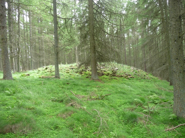
A track is found at the southern end. Follow this until a fork in the path is reached. Both paths lead to cairn. Keep going until a path heading east or west (depending on which track at the fork you take) is found. This leads straight to the cairn.
At some 23 meters wide and 2 meters tall this is a very beautiful yet private location hidden amongst the trees. To be fair, the forestry people appear to look after this cairn which is to their credit. The cairns top has been disturbed but that doesn’t detract from the feeling of age about this place. Like nearby Elrick this is a great place for contemplation and simple silence.
Visited 19/6/2010.


South of Newmachar on the A947 is the B979. Take this and head west for a mile taking the first minor road north. Go a 1/2 mile after after the first junction. Monykebbuck standing stone is in the west, Elrick cairn is some 200 meters to the east.
The cairn is some 20 meters wide by 11/2 meters at its tallest. It is protected and encircled by a fairly ruined dry stane dyke. Cairn material can be seen on the eastern flank. Very easy to find and no barbed wire fences.
A nice place to stop and chill out on a nice day. After that head into Beekies Neuk in Newmachar.
Visited 17/06/2010.

Cairn material poking thru the grass on the eastern side.

Monykebbuck standing stone over the road to the west from the top of the cairn.


Woodland Trust is ‘delighted’ by decision to throw out application for resort.
by Lucinda Cameron.
published 17/06/2010.
Conservationists were celebrating yesterday after planning permission for a luxury golf course and hotel in ancient Scottish woodland was rejected.
More info at -
pressandjournal.co.uk/Article.aspx/1786969
I know some of these guys so well done to them :-)
From Upper Broomhill the Barmekin is a fairly steep climb. I headed cross country from the track, a mistake, and headed for burnt heather which led part of the way up the hill. After this ran out the real fun began no paths, as Bill Watt said, knee deep heather and unseen holes at least two at waist deep. For quite a few yards I was able to sing in a much higher key. It is steeper than it looks but 3/4s of the way I found the/a path which led to the top. It must be said that this path is hardly ever used but at least there are no holes.
After a steepish climb the walls suddenly come into view. This is quite simply a magnificent site, one of the best (in Britain I’d say) with its 5 walls. The top two walls can be seen quite clearly all round the hill with many parts of original building remaining. It has to be said that the three other walls can be seen but are grass and heather covered but they are complete and also circle the hill entirely. Big stones can be seen dotted up and down the slopes which made me wonder if they were used for hidden bow/spearmen. Still they made a handy seat.
I’ve often wondered if the various tribes were allied as the fort at Mither Tap is quite clearly seen as can some of Dee forts. More astonishingly Durn Hill at Portsoy can just be made out some forty miles to the north. Beacons, warnings of attack who knows?
One thing I do know is that aerial photos would be the ideal here. It made the sadness, about the condition, of the Broomhill and Orde sites go away a little bit.
Luckily for me I’d found a path and followed it as zig zagged to the bottom of hill. This path would lead to Culfosie Farm, two weeks earlier the farmer here said that it was nothing but a pile of stones.............wrong!!!!!!!!!! So I headed back north following the track back to Middle Broomhill.
On the Sunday thunder and lightning had attacked Bennachie, even the phone was affected, but by Monday the rain had gone. However Mr Watts advice in his fieldnotes hold good, water proofs are essential when visiting this wonderful site.
Visited 13/06/2010.


Miles north in the distance can be seen Durn hill almost 40 miles away at Portsoy.
A few meters closer to the start of the Barmekin climb and two hut circles can be found or in my case tripped into. Unfortunately both of these have been badly damaged by deforestation.
NJ 72830757
This is quite near to the track and indentifiable thanks to basically being a green circle with banks. It is close to being 9 meters wide.
NJ 72790771
A few more meters and this hut circle can be found. Not so badly damaged the outer bank still remains with what looks like an entrance in the eastern wall. Some stone material remains.
Also in the area are signs of cultivation and small cairnfields.
Time for a climb!
Visited 14/06/2010

Hut Circle NJ 72790771.

Hut Circle NJ 72790771

Hut circle at NJ 72830757.


South from Dunecht, on the B977, turn west at the Old Wester Echt signpost. (just after the RSC). Go past the farm and stop at the next cottage.
Don’t walk into the high fenced area thru the deer gate, this is the only gate that works so I walked all round the area before arriving at square 1. Follow the track till the next track heading south. Keep on this track till the Barmekin Hill comes into view. Head up hill and east following the burnt heather. To left is the Barmekin to the right is a small hill on top of which are the remains of a badly ruined cairn.
It is badly robbed to almost non existence but its outer edges remain with possibly one kerb in place. Some cairn material remains scattered amongst the heather. But remain it does...........just. A tree marks the centre of the monument.
The cairn is named after King Orde the Pictish leader, who died here, in a battle against the Scots. Any remains of a cist and its capstone have long since gone.
Visited 14/06/2010.


2 heather covered ramparts, then two more walls. Fantastic place!


Head south from Kintore on the, well used by me, B977. At Leylodge take the Lauchentilly road west and pull in after 100 meters at the first gate.
The standing stone is the field to the south at some 11/2 meters tall. I’d never spied this stone until today but had repeatedly scanned the area when driving past.
The Lauchentilly road has the fallen stone of the same name at its end, The Knock and South Leylodge RSC plus a couple of rubbing stones near the old primary school.
Visited 14/06/2010.