


Head west from Insch on the B9002, the north side is Dunnydeer and the south side is Hill Of Christ’s Kirk both hillforts. Next west after Christ’s Kirk is the Hill Of Flinders, after that is Fallow Hill.
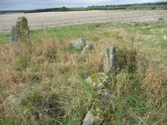
I asked permission to park at Berrybrae Farm and climbed the gentlish slopes to the top. Several fences of the barbed wire variety and some friendly cows kept me company. Not much now can be seen of the fort, aerial photography shown to me by the lady at Berrybrae, indicates at least one line of defence. On the southern side, faint remains can be seen. This area is hillfort central with Dunnydeer, Hill Of Christ’s Kirk, Mither Tap, Tap O Noth, Cairn More, Hill Of Leslie and Wheedlemont all visible from here. So with that done it was avoid presents left by the cows. Its done nothing but rain up here for weeks but today for a change it stayed reasonably dry.
Visited 24/09/2010.


The hillforts of Wheedlemont, Cairn More and Tap O Noth are to the west.

The forts interior, the cows are in front of the cairn. Tree stumps indicate the quarry.

This cairn is set at the east end of Fallow Hill on what would have been the edge of the fort. Now grass covered it is 8 meters wide and almost 1/2 meter in height. All the usual suspects Noth, Dunnydeer etc etc can be clearly seen from here. The cows proved to be friendly which after recent exploits was a pleasant change.
Visited 24/09/2010.


Looking east is Dunnydeer, and north to Candle Hill, home to a RSC.
Archaeologists discover Bronze Age burial site, arrowheads and pottery.
More info on the article posted by Strathspey.
Focus turns to Burghead Hill as funding for the Birnie site ends.
More info :


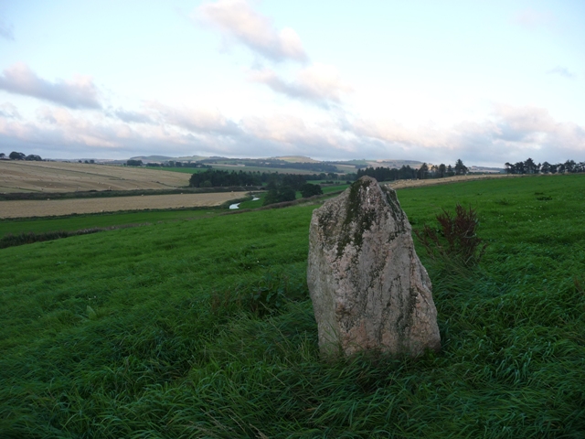
Continuing with Chris’s spinning wheel theory for Broomend. This standing stone is found to the north of Inverurie at the Brandsbutt junction. Balquhain is also in the distance, which would mean the chain of stones stretching from Tyrebagger. There is another stone in the vicinity at Dubstone.
The stone can be seen from the road and is 1.5 meters high coming to a fairly pointy peak. A walk of no more than a 100 meters. Good scenery to the northern hills, the River Urie and the Battle of Harlaw monument.
Visited 6/9/2010.
Looking south east towards Inverurie. Brandsbutt is in the vicinity.

Looking north east towards the Battle of Harlaw site (Balhalgardy). The River Urie in the valley.
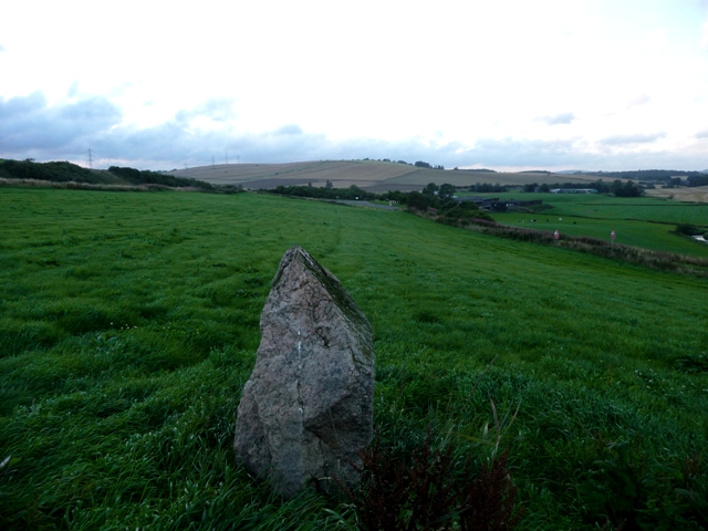


With the Black Isle and Sutherland mountains some sixty mile away in the distance.

Archaeologists working on behalf of Springfield Properties on the outskirts of Forres have found evidence of a substantial Iron Age settlement close to the site of a roundabout the firm is building as part of its new Knockromie Meadows development.
Edinburgh based AOC Archaeology are examining and recording the site before further work continues.
Project manager Martin Cook says he and his team have been sifting through trenches dug in fields close to Knockromie Meadows.
“We’ve known for a long time that it’s a very prolific area for archaeological finds,” he said ” but what we’re getting evidence of now is really very exciting. We know of another large food pit nearby, but when we examined the trenches near the roundabout we found evidence of another, larger one.”
The finds point to late Iron Age occupation around 600 AD with a large souterrain or food storage pit surrounded by post holes indicating round houses that would have used to fence off specific areas.
The entire area around the Knockromie Meadows site and beyond suggests it was occupied throughout history with evidence of Neolithic, Bronze Age, Iron Age and Roman settlements.
Previous excavations in 2007 and 2008 by AOC in a field adjacent to the current site uncovered remains indicative of people living in the area over 2,000 years ago. These included a souterrain – an underground storage passage – and several structures thought to be granaries. The floors of these latter features were raised up on posts to stop vermin and moisture getting to the grain. A cluster of postholes was also found, thought to be evidence of a multi-phase structure, possibly a roundhouse.
Springfield is delighted to have the archaeologists recovering and recording the area’s early settlement history, before covering up the site. The excavations prior to construction is a standard procedure triggered by an archaeological survey which was carried out as part of the site’s planning permission. It ensures that Scotland has a clearer picture of the previous land use by humans.
The costs involved in the archaeological dig are being met by Springfield.
Knock News Issue 41 July 2010.
‘We march down to Blackhills House. Our wonder is a garden feature. Six stone pillars support a jaunty stone-tiled roof. Within this shelter a rugged stone block perches on a little plinth. One face is pocked with a random rash of round pits. On the opposite face are two linked spirals. My map tells me that this a prehistoric Cup Marked Stone. These things are old : Neolithic-Stone Age-the age of the first farmers whose slash-and-burn and simple ploughs tore open Scotland’s soil 5,000 years ago-or maybe more. We do not touch the carved designs, though tempted. There is an ancient magic here that urges us to trace the spiralled coils or to place a finger in each pecked-out cup. But what supernatural forces might inhabit the stone-awaiting ritual release.‘
John Barrett.
Knock News Issue 42 August 2010.
Sadly this cairn will gradually fade into memory thanks to farming and deforestry. Marks of damage can already be seen. Still it is 8.5 meters wide standing at 0.5 meters tall, the platform giving an idea of height. Several kerbs remain in place on the western side. The centre of the site shows a rectangular feature despite houking damage. Somehow I contrived to walk back down the hill and forget about a much larger cairn some 60 meters to the south. Doesn’t matter as I would think my feet will be back in this area fairly soon.
Pull into the farm, east, after Migvie church and follow the track heading in a north easterly direction until the fir trees. The cairn is in the trees to the north of the track on the eastern side.
Visited 3/08/2010.
The detailed account of the excavation by Professor Alexander Low during 1935. There are pictures of the cist, urn and various other finds.
‘On the summit of Mither Tap (1698 feet) are the ruins of what is probably a Pictish fort. It was an enormous structure, the total circumference of which must have been over 700 feet. The outer wall is fully fifteen feet in thickness and is carefully built with well coursed masonry having a rampart walk and a parapet. Inside the protected area were found the remains of around ten hut circles, a well and a second wall.‘
Algy Watson.
Oyne Past and Present.
‘Two graves of an early historical age, containing some bones and dust, and at least one burial urn were found on the farm of Newlands. In the beginning of August, 1932, the cover stone of a short cist was discovered while excavation was taking place for material to repair the road leading up to the farm of Newlands. On raising this stone a short cist was uncovered on the floor of which lay the remains of a human skeleton and an urn. Mr. George Murray, the farmer, removed the urn to his house, left the bones undisturbed and replaced the cover so that the burial might be examined by one familiar with such deposits. This was a typical short cist of the early Bronze Age and was formed by four slabs set on edge, one at each side and one at each end. The urn which belongs to the beaker class was found intact apart from two cracks on opposite sides of the lip.‘
Algy Watson.
Oyne Past and Present.
I wondered why these stones were fenced in, not likely they’d escape, but they do seem to have moved. Near Standing Stones farm I looked for a stone circle/kerb cairn but was told the stones were piled up near the standing stone.
They are situated just slightly to west of the standing stone, on the other side of a brand new barbed wire fence.
Visited 31/07/2010.

Finding this cairn showed real signs of stupidity and signs of a never give up nature. How I didn’t injure myself doing this walk, a very naff description of events, is nothing short of a miracle.
Things started well, went east from Dinnet on the A93, turning north at St James. Follow this track until the tar runs out but keep going until the next turning, the last house, and pull in. From here follow the track north until the remains of farmers croft. Turn east and up thru the trees. From here a nightmare begins. Basically hack your way thru ferny things like trees, after 1 hour I was knackered climbing Mulloch Hill. I couldn’t turn back and I was never going to be able to climb to the top so I headed towards trees in the south east. Another hour of hacking and tramping before I reached them. At least it was easier to walk beneath the branches. The cairn is easily enough found.
Basically a cairn of big boulders. Sitting at 15 meters wide and at it’s tallest 0.7 meters. I thought there was a trace of a kerb thanks to some bigger stones near the edge of the cairn. One thing for sure was the silence, I don’t think I heard a thing apart from me glugging from a water bottle! There was no point in going on, Id intended visiting 8 sites but could only manage one. There is no easy way here. Agonisingly the hilltop was close but it might as well have been miles away. The way back down was just as difficult. Eventually I made it back to the car battered and bruised. The pub in Tarland made for a safe haven. Next time I’ll approach from the north at Ordie.
(for a bonus Paul Anderson, who wrote a piece of music for the stone circles was playing. The trumpet player and violinist compared notes.)
Visited 5/08/2010.
Several boulder kerbs remain in place of this robbed cairn set on top of small hillock in the middle of a field near Migvie Church. Sadly a lot of damage has been done with all types of rubbish, field clearance, wood chips etc flung on top. Also a cattle feeder, thats 3 sites with cattle feeders dumped on them all in the same area. Same farmer?
From the A97 travel east on the Migvie road pulling in at the farm just after the kirk. The cairn is in the field to the south.
Visited 3/08/2010.


Drummy is the home to the Blue Cairn and Corrachree kerb cairn as well as a number of hut circles, three of which I managed to find. Unfortunately others were covered in heather/ferns or in amongst boggy stuff. So basically follow the directions to Corrachree and then use your eyes. There is also a cairn with fallen monoliths but that was hidden from view on the day I visited, plus I was rather damp. There is always another day!
Visited 2/08/2010


