
Two nice aerial pics.
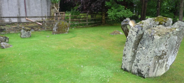
Balnabroich Farm is on the east side of the A924, south east of Kirkmichael, and has the two poster and standing stone nearby. Moreorless opposite this is the road to Stylemouth. After a quick conversation with the owners, several chickens and a very friendly dog I was very kindly allowed to park.
From here head uphill and jump over the gate. By this time it is flatter but keep heading east and climb the next gate, near a small weather centre, keep going until the next gate. Over that and the Grey Cairn can be seen. Looking south which today is bathed in sunshine looking glorious.
Keep looking south of the path and another cairn and hut circle (an excellent example) can be seen. I’ll discuss them in other fieldnotes.
A lot has been done to this cairn and the excesses of previous excavations can clearly be seen. It still stands at 27 meters wide and is 1.7 meters high. Originally it stood at over 7 meters in height which gives a fair idea of the damage done. Still it has impressive views and as I was to find out there is a lot going on in this area.
Visited 8/8/2013.


I ordered the rain not to harm me today. It did as it was told.


In the wood behind, right, is the 2 poster.

In the distance these sheep might have been trouble.


After purchasing some ‘wets’ and boots in Pitlochry I was back on my travels. Unlike the Canmore picture, obviously taken some time ago, Tulloch cairn is covered in trees. Also unlike the old picture the south side of the cairn is damaged, maybe weather affected but with some human assistance. However this does let us see how the cairn was constructed. It sits at over 27 meters wide, 4 meters high and has a 10 meter plateau on top.
I pulled in on the north side, after the Tulloch B and B, on the A924. Follow the track thru a small wood until a corregated iron hut. The cairn is next to the track on the north side.
Unfortunately there was more to see at the cairn than I’d expected. What looks like ritualistic slaughter/sacrifice has happened. Skulls of various beasts are sitting on rocks to the north side all over the place. More sinister is a circle of skulls with a bigger skull sitting in the middle. Sadly several rotting carcasses are nearby. Bones are splattered all over the place. (see pics) Who or whatever did this, imo, have a very sick attitude. I contacted the police and investigations are under way, so far fox traps have been ruled out. Once I find out more I’ll post it here.
Visited 1/8/2013.
The Witch’s Stone has somehow been classified as a standing stone by Canmore, obviously drinking whatever old Fred Coles or possibly myself drank. More likely it is a massive glacerial sitting at 7 meters wide and 7 meters tall complete with a tree growing on top. On another day magnificent views of the Ardle valley would be seen but today clouds and mist. At least it had stopped raining, for a wee while. There must be hopefully some folklore about this place.
Visited 1/8/2013.
After falling into the depths it was all downhill. Downhill towards a cairn to the west of the track (on the biggest corner). This cairn has also been much battered and robbed but several kerbs remain in defiantly in place. An excellent viewpoint, it showed me even more rain coming from the south.
Visited 1/8/2013.


Most of the kerbs of this cairn are in the south eastern arc with several kerbs being displaced in other areas. Sadly this cairn has had it’s punishment thanks to robbery, houking and general agriculture e.g. cattle. Still it survives but how long would be a good question. Other small cairns make a cairnfield which also is getting the treatment.
Visited 1/8/2013.


Looking south westish, Cnoc an Diamh hides in the clouds north westish.


These hut circles or rectangles are situated near the four poster and are easily seen from the track to the east.
NO12926271 is the northern hut.
NO12866263 the second hut has a possible enclosure as well.
Visited 1/8/2013.


