
The cairn at SX 26833 70162, on the southwestern edge of the group. It’s built around a granite outcrop.
Image credit: A. Brookes (22.6.2018)

The cairn at SX 26833 70162, on the southwestern edge of the group. It’s built around a granite outcrop.

The huge cairn at SX 26852 70058 from the northwest. Although it looks like a ring cairn, the centre is full of stone but it’s turfed over.

The western arc of the cairn at SX 26852 70058.

Stones of the southernmost cairn at SX 26852 70058.

The cairn at SX 26852 70058, the southernmost in the group and at 23m across the biggest on the hill.

Kerbing and cairn material on the eastern side of the tor cairn at SX 26966 70186.

Edge-set granite slabs in the kerb of the tor cairn.

Detail of the kerb and cairn material of the tor cairn at SX 26966 70186.

The tor cairn at SX 26966 70186, the most unusual of the monuments on Caradon Hill. A kerb of edge-set slabs surrounds most of the granite outcrop in the centre.

Quartz block exposed in the centre of the cairn at SX 26976 70323.

Smaller, centrally disturbed cairn at SX 26976 70323, on the western edge of the group.

The cairn at SX 26988 70283. The centre is a little damaged, but this is a fine example of an upland cairn.

Excellent cairn at SX 26988 70283, looking over the western slopes of the hill.

Looking north across the big cairn at SX 27085 70314 towards the summit. The nearest cairns of the northern group are around the masts.

The mostly intact top of the big cairn at SX 27085 70314.

The massive cairn at SX 27085 70314.

Massive cairn at SX 27085 70314, standing over 2m tall and the best part of 20m across.

Neat cairn at SX 27208 70282, towards the northeastern edge of the group.

The relatively small cairn at SX 27260 70284, the easternmost in the group. It enjoys extensive views east and southeast. The hill over to the left is Kit Hill. Behind that the edge of Dartmoor fills the skyline.

The top of the cairn at SX 27115 70385. Difficult to see for the blue on blue, but the sea near Looe can be seen on the horizon.

The round cairn at SX 27115 70385, the northernmost in the group. Looking south.

The southernmost cairn in the group at SX 27073 70541. I didn’t pay this one much attention, but the stones to the right of centre are the possible cist elements mentioned in the miscellaneous post.

The badly damaged cairn at SX 27114 70566, a victim of stone-robbing that has left a very low, uneven mound.

The pretty trashed cairn at SX 27119 70608.

Very low remains of the banked cairn at SX 27170 70633. The encircling bank is quite clear, but the central mound has practically disappeared.

The prominent platform cairn at SX 27215 70682.

Detail of the inner mound of the platform cairn at SX 27215 70682, with the outer bank behind.

Platform cairn at SX 27215 70682. The monument is the most prominent of the group, consisting of a high central mound with an outer bank.

The round cairn at SX 27216 70717. Stowe’s Pound can be seen on the far left, with Langstone Downs and Kilmar Tor beyond.

Damaged and relatively small round cairn south of the OS trig pillar at SX 27303 70733. The vegetation beyond covers the nearby embanked platform cairn on the highest point of the hill. To the left of that is the top of Stowe’s Pound and to the far left, distant Brown Willy can be seen on the skyline.
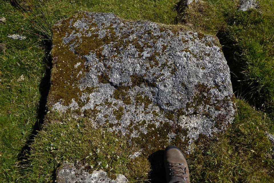
Exposed slab in the centre of the embanked platform cairn at SX 27280 70791, boot for scale.
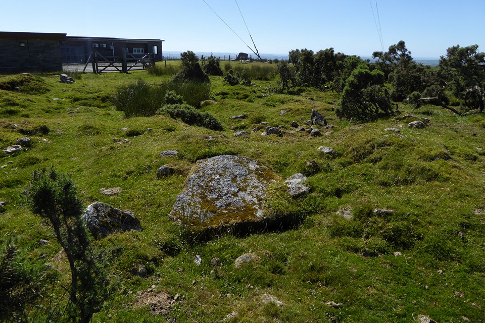
The pitted centre of the embanked platform cairn at SX 27280 70791, showing exposed slab.

Embanked platform cairn at SX 27280 70791. This is the summit cairn.

Impressive section of double kerb around the inner mound of the banked cairn at SX 27331 70870.

The apparent chamber or cist in the banked cairn at SX 27331 70870.

The central mound in the banked cairn at SX 27331 70870, showing a probable cist or chamber.

The excellent banked cairn at the northern end of the group (SX 27331 70870). The monument consists of a low rubble bank (like a ring cairn) seen in the foreground, enclosing a kerbed inner mound. In my opinion this is the most interesting monument in the group.

Detail of the well-defined rubble bank of the ring cairn at SX 27377 70759.

Remains of kerbing on the ring cairn at SX 27377 70759.

The southeastern arc of the ring cairn at SX 27377 70759, looking eastwards off the moor, towards Kit Hill in the middle distance and the distant edge of Dartmoor beyond.

The ring cairn at SX 27377 70759, from the east.
Scattered group of 9 Bronze Age round cairns located on the southern slopes of Caradon Hill.
Details of the cairns from the National Heritage List For England, generally northeast to southwest:
Round cairn 310m west of Heather House (SX 27260 70284)
The cairn survives with a low sub-circular mound measuring up to 16.5m north west-south east by 14.1m north east-south west, the mound slightly truncated along its north east edge by a ditch accompanying a substantial post-medieval wall which passes 1m beyond the cairn’s visible edge, following the line of a medieval manorial and parish boundary. The cairn’s mound has a low, shallow-domed profile, up to 0.9m high, but relatively recent small-scale quarrying for wall stone has produced an uneven surface with several rounded hollows running in from the edges of the mound.
Round cairn with peripheral berm 402m SSW of Caradon Hill summit (SX 27115 70385)
The cairn survives as a circular mound, 21m in diameter and up to 2m high, of heaped small stones; around the SW and W sectors a distinct ledge, or berm, 0.5m wide, is visible in the mound’s periphery at a height of 0.3m. Some stone extraction has occurred in the relatively recent past, resulting in a lowering of the cairn’s interior in the E and S sectors but not reaching the base of the cairn, and in its N half the cairn survives undisturbed to full height as a consolidated turf-covered mound.
Round cairn 472m SSW of Caradon Hill summit (SX 27208 70282)
The cairn survives as a well-preserved circular turf-covered mound, 11.5m in diameter and 1m high, composed of heaped small to medium-sized stones. The mound rises to a flattened upper surface 7m in diameter and has survived essentially intact.
Round cairn 480m SSW of Caradon Hill summit (SX 27085 70314)
The cairn survives as a circular mound, largely turf-covered, 18.5m in diameter and up to 2.25m high, of heaped small to medium-sized stones, with occasional larger stones up to 1m long. Some relatively recent stone- quarrying is evident as limited depressions up to 1m deep in the N half of the cairn’s central area.
Round cairn 527m SSW of Caradon Hill summit (SX 26976 70323)
The cairn survives as a circular mound, largely turf-covered, 11m in diameter and up to 1.75m high, of heaped small to medium sized stones. Some stone extraction has occurred in the relatively recent past, removing stones from the central 2-3m diameter area and the SSE side of the cairn, but leaving the remainder of the cairn’s mound intact and well-consolidated.
Round cairn 557m SSW of Caradon Hill summit (SX 26988 70283)
The cairn survives as a circular mound, 16.5m in diameter and up to 1.5m high, of heaped small to medium sized stones. Some stone extraction has occurred in the relatively recent past, removing stones from the central area and hollowing it to a maximum depth of c.0.75m, but leaving the remainder of the cairn’s mound intact and well-consolidated.
Tor cairn with adjacent sub-rectangular hut 650m SSW of Caradon Hill summit (SX 26966 70186)
The monument includes an ovoid tor cairn with a peripheral bank and kerb, and a later sub-rectangular hut adjoining the cairn’s S edge.
The tor cairn survives as a low ovoid bank, measuring 34m NE-SW by 27m NW-SE externally, 2-3m wide and up to 0.5m high, composed of heaped small to medium sized stones. The bank’s inner edge is defined by a row of edge- and end-set boulders and slabs up to 1m high forming a distinct kerb around the N, E and S sides. Within the kerb is an almost level surface covering a thin platform, of compacted and largely turf-covered small to medium stones. The cairn’s platform surrounds a natural granite outcrop, 22m long and rising to 2.5m above the neighbouring land on the crest of the spur, forming a clear natural spine along the cairn’s long axis. The outcrop comprises weathered slabs, tilted to the SE with a scarp along its NW edge, and widens from 3m at the NE end to 11m at the SW. The cairn platform is represented on the outcrop’s upper face by a discontinuous thin layer of compacted small stones. The S edge of the cairn’s bank and platform has been modified by the insertion of a sub-rectangular hut of a form typical of early medieval stock herders’ huts on Bodmin Moor. Externally the hut measures 6m N-S by 5m E-W, with rubble walls 1.5m thick and 0.5m high, probably of stone robbed from the cairn. No certain entrance is visible.
Round cairn 740m SSW of Caradon Hill summit (SX 26833 70162)
The monument comprises a round cairn on and around a natural rock outcrop.
The cairn survives as circular mound, 14m diameter and up to 1.75m high, composed of small to medium-sized stones, up to c.0.5m long, heaped upon a small natural flat rock outcrop, extending beyond its edge on the N and E sides, but defined by a sheer drop along the outcrop’s S and W sides. The outcrop clearly forms the bulk of the cairn’s volume, but the heaped stone is well-consolidated and largely turf-covered, with no evidence for any previous disturbance.
Round cairn and shelters 812m SSW of Caradon Hill summit (SX 26852 70058)
The monument comprises a large circular funerary cairn with two small shelters scooped into one side, at the SW end of a linear cairn group.
The cairn survives as a large circular mound, 23m in diameter and up to 2m high, of heaped stones varying in size from small pebbles to small boulders up to 1m across. Some stone extraction has occurred in the relatively recent past, removing stone from the NNW side of the cairn, extending to the mound’s centre, but leaving the remainder of the cairn’s mound intact. The surface beneath the area from which stone has been removed retains well-consolidated stone of the cairn mound, 0.4m above the external ground level, and is largely turf-covered. In the E and SE sides of the cairn are two small scoops in the stone rubble content of the mound, each 3m in diameter and 0.75m deep, separated by a very coarsely-built drystone wall. Such structures are typical of short-term shelters for medieval and post-medieval workers on the moor.
Group of 10 Bronze Age round cairns located across Caradon Hill’s summit dome on an overall alignment south west from the summit.
Details of the cairns from the National Heritage List For England, north to south:
Banked cairn 125m NNE of Caradon Hill summit (SX 27331 70870)
The monument comprises a large circular embanked funerary cairn, part of a linear cairn group near the summit of Caradon Hill on SE Bodmin Moor. The cairn survives as a circular bank of small stones, 19m in external diameter, 2-3m wide and 0.5m high, encircling a central mound, 12m in diameter and up to 1.5m high, composed of medium to large stones. Around the S and SW sectors of the central mound’s edge are a row of end-set, inward-sloping, large slabs surviving from a retaining kerb.
The surface of the central mound shows a number of hollows from stone-robbers, whose spoil has been dumped largely over the N and NE sectors of the cairn, filling the space between the mound and outer bank in that area. The same activities are responsible for a pit in the NE part of the mound, exposing a large natural boulder in its base; this pit is the only disturbance to reach a significant depth into the body of the cairn, and is off-centre and restricted in extent; consequently it is considered that any primary funerary deposits at the centre of this monument, and secondary deposits made in most other areas, will survive intact, together with the old land surface on which the monument was constructed.
Embanked platform cairn 47m NW of Caradon Hill summit (SX 27280 70791)
The monument comprises a large circular platform cairn with a peripheral bank, part of a linear cairn group near the summit of Caradon Hill on SE Bodmin Moor. The cairn survives as a large, circular, flat-topped platform of heaped small stones, 30m diameter and 0.4m high. The bank on the platform periphery starts 3m from platform edge, leaving a clear peripheral berm; the bank is also composed of heaped small stones and survives 2m wide and generally 0.5m above the platform level, rising to 1m high in the NW sector; it is visible around the entire periphery except the disturbed S sector. The cairn interior bears no trace of any internal mound, but has a number of hollows and hummocks from limited stone-robbing from the cairn. One such hollow exposes part of a recumbent slab, appearing 1m square, at the cairn’s centre. The entry for these activities has been from the S and SE sector, where the peripheral bank and platform edge have been reduced.
Ring cairn 77m E of Caradon Hill summit (SX 27377 70759)
The monument comprises a large, circular, funerary ring cairn, part of a linear cairn group near the summit of Caradon Hill on SE Bodmin Moor. The cairn survives as a large circular ring, 24m external diameter, 4-5m wide and up to 1m high, comprising heaped small stones with occasional larger boulders, an arrangement typical of the cairn type termed a ring cairn. Three of the larger boulders remain as upright slabs within the cairn’s N sector, forming the remains of a stone kerb within the body of the cairn. The interior of the ring cairn is almost stone-free, with no evidence for previous disturbance, and conforms in both level and slope with the external ground surface.
Round cairn 15m SSE of Caradon Hill summit (SX 27303 70733)
The cairn survives as a low circular mound, 15m diameter and up to 0.4m high, composed of heaped small stones. The cairn has been subject to some stone removal in the relatively recent past, modifying its original form by hollowing the central area within an undisturbed, turf-covered 2.5m wide periphery but leaving intact a consolidated stone cover overall. As a result of this stone cover, it is considered that sub-surface funerary deposits and the old land surface beneath this cairn will have survived undisturbed. A small stone-heap 4m diameter and 1m high on the SSW periphery of the cairn is clearly a mound of waste from the stone-robbing and not an original feature of the Prehistoric cairn.
Round cairn 82m SW of Caradon Hill summit (SX 27216 70717)
The cairn survives as a circular turf-covered mound, 26m diameter and up to 1m high, comprising heaped small stones with occasional larger boulders visible; the N and W perimeters of the cairn are particularly well-defined. In the interior, some relatively recent disturbance for stone-robbing is evident as a shallow trench, 3m wide, running in from the SSW almost to the N edge, together with several linear mounds and hollows parallel to it on each side. This disturbance penetrates only to a limited depth within the cairn and it is considered that sub-surface funerary deposits and extensive areas of the old land surface will have survived intact beneath it.
Platform cairn 110m SW of Caradon Hill summit (SX 27215 70682)
The cairn has a central turf-covered mound, 13m diameter and 2m high, composed of small to medium-sized stone. The mound has a hollowed upper surface, 5m in diameter and 0.6m deep. The mound drops to the level of the platform, 0.5m higher than the external ground level. On the periphery of the platform is the outer bank, 22m in external diameter, 2-3m wide and 1.5m high, leaving a gap 1.5-2m wide to the central mound. No trace of the platform projects beyond the bank. The bank has some gaps in its S sector due to recent stone robbing, but this cairn shows no evidence of any major disturbance.
Banked cairn 175m SW of Caradon Hill summit (SX 27170 70633)
The cairn survives with an irregular central mound, c.10m in diameter and up to 1m high, composed of small to medium stones, with a number of smaller heaps and hollows in its surface deriving from the relatively recent activities of stone-robbers which have also spread the mound towards the outer bank in the S half. In the less disturbed N and NW sectors a clear gap, 4m wide and at the same level as the external ground surface, is observable between the central mound and an encircling bank, 22m in external diameter, 2-2.5m wide and up to 0.4m high. This bank is also composed of heaped small stones.
Round cairn 230m SW of Caradon Hill summit (SX 27119 70608)
The cairn survives as a circular mound, 18m diameter and up to 0.75m high, composed of heaped small and medium sized stones visible in breaks in the turf cover. The surface of the cairn shows some slight hollows from relatively recent stone-robbing but, with one exception, these are both of limited extent and depth. This exception is a pit, 4m long by 2m wide, dug 1m deep into the SW edge of the cairn to expose a large ground-set boulder from which one end was subsequently split away by drilling. Beyond that peripheral pit, the body of the cairn remains substantially intact, as will any funerary deposits associated with it.
Round cairn 520m north west of Heather House (SX 27114 70566)
The cairn survives with a low rounded mound up to 18.8m in diameter and to 1m high. Parts of the mound’s original surface show a formerly shallow-domed, almost flattened, profile however its present visible form has been affected by post-medieval quarrying for wall stone. That has lowered an area about 6m across at the centre of the mound though it remains above the ground level surrounding the cairn, with discarded rubble and soil heaped unevenly onto intact areas of the cairn’s periphery; several hollows pass across that periphery to give access to the central quarried area.
Platform cairn 550m north west of Heather House (SX 27073 70541)
The cairn survives with a low rounded mound up to 18.25m in diameter and up to 0.6m high. The mound rises over its peripheral 1m-1.5m to a flattened upper platform, a profile slightly modified in some areas by post-medieval rubble extraction which has produced several shallow hollows running onto the cairn from the edges. Occasional small stones from the cairn’s rubble fabric are exposed in the turf, but slightly north east of centre, a group of larger slabs, some edge-set and up to 0.8m long, break through the surface turf and are considered to derive from a slab-built funerary structure called a cist.
Further relatively recent stone extraction occurs on the cairn’s southern edge, which has been dug away to expose a large natural boulder; the west end of the boulder was split away using the plug-and-feather technique characteristic of 19th century and later stone-splitting. The break was clearly unsuccessful with the split end left where it fell, but one of the holes intended to guide the next break still retains its broken iron plug and two feathers jammed in place.

The two barrows are slowly disappearing under the gorse again. This is the better SE barrow.

One of the smaller round houses.


Solstice offering of cotton grass and heather.


