Midsummer chalkland vegetation, in contrast to my previous midwinter visits.
Image credit: A. Brookes (10.6.2023)
Midsummer chalkland vegetation, in contrast to my previous midwinter visits.

Looking southwest, with Rybury beyond on the right.

Ditch on the left, looking northwest towards Cherhill.

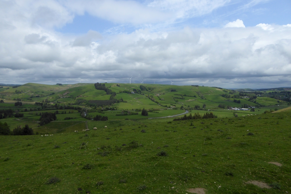
Clifford’s Hill (left) and Rybury (centre) from the lower slopes of Tan Hill to the northeast.

Looking east from the earthwork on Clifford’s Hill, towards Milk Hill, the highest point in Wiltshire. Over to the right of centre, Adam’s Grave long barrow is prominent on its own hilltop.

Rybury from Clifford’s Hill, with Tan Hill rising behind.


Western flank, looking back up to Tan Hill.


Rybury from Tan Hill. The earthwork annex to the left can be clearly seen from here.

The round barrow at SU07866490.

The round barrow at SU07866490. The summit of Tan Hill is on the left.

The round barrow at SU07866490. The main western group of barrows is on top of the spur to the right.

The isolated round barrow at SU07866490. King’s Play Hill and Morgan’s Hill on the distant skyline, centre and right.
A further isolated barrow stands on its own on the western shoulder of Tan Hill, to the east of the main group at SU07866490. EH description:
The barrow stands to a height of 1m, surrounded by a 2m deep quarry ditch, from which material was obtained during its construction. This has become infilled over the years but survives as a buried feature. A shallow depression on the centre of the barrow suggests the site has been partially excavated, probably in the 19th century, although no details are known.

Landscape context for the prominent long barrow, centre skyline. Tan Hill rises over on the right. Seen from the southwest near Field Barn.

The prominent barrow on the skyline. Seen from Wansdyke (in the foreground) to the southwest.

Easton Hill from the west, showing the prominence of the hill above the farmland below. The western barrow is on top of the spur.

Caer Caradoc on the left, with Hope Bowdler Hill (Iron Age field system and possible cairn) on the right. In the distance between them is The Wrekin. Seen from Ragleth Hill to the southwest.

Grindle is centre. The two surviving barrows can just be seen silhouetted to the left of the high point (where the third barrow has been destroyed). Pole Bank, the highest point on the Long Mynd is to the right. The village below is Little Stretton. Seen across the valley from Ragleth Hill to the ESE.

Norton Camp is in the distant centre of shot, flanked by Callow Hill on the left and View Edge on the right. Extreme right is the excellent Burrow hillfort. Seen from Ragleth Hill near Church Stretton to the north.

Looking across to Fan Nedd. The two cairns on that mountain are visible from here. Beyond the right-hand end of Fan Nedd’s summit ridge, the escarpment of Y Mynydd Ddu sneaks into view.

Looking southwest in the general direction of Glyn Neath. There are cairns on most of the skyline hills.

There’s quite a sizable stone half-buried in the turf on the western side of the cairn’s footprint.

Quite the contrast to the hail of my previous visit. Looking towards Corn Du.


Some of the nearby forestry has been felled, opening up the view west towards Carreg Cadno.


Fan Gyhirych on the skyline, seen from the shattered limestone summit of Carreg Cadno (’Fox Rock’, colloquially). The area in between is an amazing limestone pavement, with lots of sinkholes and a huge underground cave system beneath.

The near-vertical southern aspect of Craig y Rhiwarth, seen from the Tawe valley to the south.

The cairns are big enough to be visible from the Gwy/Wye valley far below and several miles away. This is taken from the Wye Valley Walk near Hendre, Llanifyny.

Some landscape context of the upper reaches of the Gwy/Wye valley. Pen Pumlumon-Arwystli is centre skyline, with Pen Pumlumon Fawr over to the left. The Gwy runs along the valley below, on its route from the slopes of the mountain. From Esgair Lwyn-Gwyn to the southeast.
From the BBC website, story by Andrew Dawkins;
Archaeologists excavating the area around an historic stone formation believe a man-made ring of stones, known as a stone circle, may have been found at the site.
Arthur’s Stone in Dorstone, Herefordshire, is said to mark the spot where King Arthur slew a giant.
Professor of archaeology at The University of Manchester Julian Thomas said a survey had shown up a circle about 20m (65.6ft) across that seemed to “not be of natural origin”.
....
Prof Thomas said when work started at Arthur’s Stone, a trench was opened up “the other side of the hedge from the monument”.
He added: “[We] found that there are further prehistoric features there, so we’ve got an avenue which starts out as an avenue of timbers and is replaced by an avenue of stones.
“[This] runs down the hill from the monument itself and as a response to that, we conducted further surveys.”
Prof Thomas said one thing it showed up was a circle, which “looks like it’s perhaps a barrow or a timber circle or a stone circle”.
But it was “certainly something made by human beings” and about half of that was now being opened up, with a stone circle thought to be the most likely outcome.
Full story at bbc.co.uk/news/articles/cjqeyv5qnyeo.amp


Approaching on the lane from Parson’s Bridge.


This is a great little cairn circle. Unfortunately the residents didn’t seem keen to invite a long stay.


Landscape contxt, approaching from the west. The cairn circle is just to the left of the cattle.