Skip to content
Julian Cope
presents
The Modern
Antiquarian
Latest
Posts
Sites
Map
Blog
Forum
search
Search
⚠️
Sign in
more_horiz
Eire
County Tipperary
Ballinahinch
Ballinahinch
Barrow / Cairn Cemetery
R753684
expand_more
Nearest town:
Ballina (6km WNW)
OS reference:
R753684
OS sheet:
59
Latitude:
52° 45' 58.17 N
Longitude:
8° 21' 57.48 W
Added to TMA by
bawn79
Images (1)
Add
content
Images
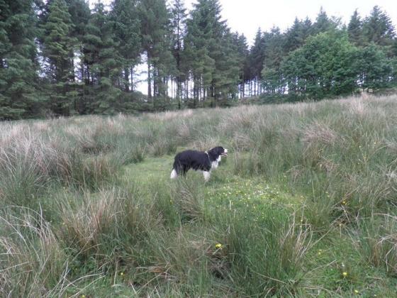
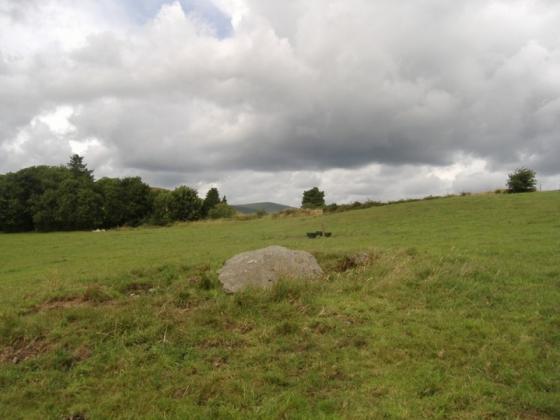
Barrow 2 is a conjoined barrow
Image credit: Bawn79
bawn79
Dec 18, 2006
Sites within 20km of
Ballinahinch
Ballinahinch
Barrow / Cairn Cemetery
•
0.1km WSW
photo
1
Ballinahinch
Barrow / Cairn Cemetery
•
0.2km SSE
photo
1
description
1
Garruan
Standing Stone / Menhir
•
1.2km NE
photo
1
Garraun
Round Barrow(s)
•
1.2km NE
photo
2
description
1
Clonalough
Standing Stone / Menhir
•
1.7km ENE
photo
1
description
1
Ballynahinch
Round Barrow(s)
•
1.84km W
description
1
Ballynahinch
Round Barrow(s)
•
2.09km WSW
photo
2
description
1
Ballynahinch
Round Barrow(s)
•
2.09km WSW
photo
1
description
1
Cappadine
Standing Stone / Menhir
•
2.2km NNW
photo
4
forum
1
description
1
Ballyard
Bullaun Stone
•
4.44km SW
photo
2
description
1
Ballina
Standing Stone / Menhir
•
4.57km WNW
forum
1
description
1
Roolagh
Standing Stones
•
5.78km WNW
photo
4
description
1
Birdhill
Standing Stone / Menhir
•
6.01km WSW
photo
5
description
1
Ballymalone More
Standing Stone / Menhir
•
6.28km NW
photo
1
description
1
Killaloe
Standing Stone / Menhir
•
6.49km WNW
photo
3
description
1
Burgesbeg
Standing Stone / Menhir
•
6.85km NNE
description
1
Burgesbeg
Standing Stones
•
7.46km N
photo
5
description
1
Coumroe
Stone Circle
•
8.11km N
photo
3
description
1
Carrigeen
Stone Row / Alignment
•
8.15km NNE
photo
7
Bauraglanna
Stone Circle
•
8.47km E
photo
6
description
3
Scraggeen
Standing Stones
•
9.11km S
photo
1
description
1
Graves of the Leinstermen
Standing Stones
•
9.62km NNW
photo
6
description
4
Laghtea
Hillfort
•
10.07km NNW
photo
1
description
1
Knockaunreelyon
Natural Rock Feature
•
10.1km NNW
photo
1
description
1
Craglea
Natural Rock Feature
•
10.11km WNW
photo
1
forum
1
description
2
Lackamore
Wedge Tomb
•
10.54km N
photo
2
description
1
Garranbane
Wedge Tomb
•
11.09km S
photo
2
description
2
link
1
Reardnogy More
11.71km ESE
photo
2
description
1
Sonnenstein – Beckstedt
Cup and Ring Marks / Rock Art
•
11.82km WNW
photo
3
description
2
Ardataggle
Wedge Tomb
•
11.94km WSW
Kilcolman
Sacred Well
•
12.08km NNE
photo
1
description
1
Doonglara (Glenbrohane)
Rath
•
12.28km S
description
1
Baurnadomeeny
Standing Stone / Menhir
•
12.3km ESE
photo
5
description
1
Baurnadomeeny
Cairn(s)
•
12.32km ESE
photo
2
description
2
Tullahedy
Artificial Mound
•
12.36km NE
photo
1
description
1
Lisheentyrone
Cup Marked Stone
•
12.4km N
photo
3
description
1
Lisheentyrone
Standing Stones
•
12.4km N
photo
9
forum
1
description
1
Baurnadomeeny
Wedge Tomb
•
12.57km ESE
photo
36
forum
2
description
2
Cureeny Commons
Wedge Tomb
•
12.87km E
photo
16
forum
1
description
1
Creggane
Wedge Tomb
•
12.95km NNE
photo
1
description
1
Shanballyedmond
Court Tomb
•
13.13km ESE
photo
17
Pestruper Gräberfeld
Megalithic Cemetery
•
13.3km NW
photo
7
description
1
link
1
Cloneygowny
Bullaun Stone
•
13.35km N
photo
1
description
1
Goulmore
Standing Stones
•
13.58km ESE
photo
3
description
1
Mauherslieve
Cairn(s)
•
13.69km E
photo
5
description
2
Mauherslieve
Sacred Hill
•
13.69km E
description
1
Foilnamuck
Wedge Tomb
•
14.16km E
photo
9
forum
1
description
1
Foilnamuck
Standing Stone / Menhir
•
14.54km E
photo
4
description
1
Youghalvillage
Sacred Well
•
14.56km NNE
photo
3
description
1
Garranmore
Bullaun Stone
•
14.63km N
photo
2
description
1
Cooneen
Cairn(s)
•
14.94km E
photo
7
description
1
Cooneen
Kerbed Cairn
•
14.95km E
photo
2
description
1
Bealkelly
Wedge Tomb
•
15.16km WNW
Killokennedy
Wedge Tomb
•
15.4km W
photo
5
Formoyle More West
Wedge Tomb
•
16.31km W
photo
6
description
1
Knockshanbrittas (A)
Wedge Tomb
•
16.53km ESE
photo
6
Aughsullish SW
Wedge Tomb
•
16.53km ESE
photo
5
description
1
Aughsullish NW
Wedge Tomb
•
16.54km ESE
photo
1
Foilycleara
Wedge Tomb
•
17.09km ESE
photo
2
description
1
Cloongaheen West
Wedge Tomb
•
17.15km W
photo
4
Ballinacurra
Cairn(s)
•
17.19km ENE
description
1
The Bargaining Stone – Inishcealtra
Natural Rock Feature
•
17.27km NW
photo
2
Lackanagoneeny
Stone Row / Alignment
•
17.29km SE
photo
2
description
2
Barbane
Wedge Tomb
•
17.4km W
photo
6
Knockalton Lower
Standing Stone / Menhir
•
17.43km NE
photo
1
forum
2
Iniscaltra
Christianised Site
•
17.46km NW
photo
4
link
2
Iniscaltra
Bullaun Stone
•
17.65km NW
photo
2
description
1
Reisk
Standing Stone / Menhir
•
17.79km E
description
1
Ardskeagh
Wedge Tomb
•
17.87km W
Loughbrack
Wedge Tomb
•
17.88km E
photo
10
description
1
Knocknabansha
Wedge Tomb
•
17.97km E
photo
4
description
1
Drummin
Wedge Tomb
•
18.18km W
Tuogh
Bullaun Stone
•
18.51km SSE
Violethill
Wedge Tomb
•
18.56km W
Knockshanvo
Wedge Tomb
•
18.65km W
photo
4
description
1
Rathurles
Rath
•
18.94km NE
photo
1
description
1
Knockeen
Enclosure
•
18.98km SSW
description
1
Knockmaroe
Wedge Tomb
•
19.26km E
photo
2
description
1
Gortnageragh
Cairn(s)
•
19.26km ESE
photo
1
description
1
Rathfalla
Henge
•
19.41km NE
photo
4
forum
1
description
1
Garracummer
Ring Cairn
•
19.48km ESE
photo
7
description
1
Rathurles
Rath
•
19.53km NE
photo
2
description
6
link
1
Rathurles
Standing Stones
•
19.67km NE
photo
5
description
1
Knigh Hill
Cairn(s)
•
19.94km NE
photo
3
search
I’m looking for…
location_on
photo
ondemand_video
forum
description
link