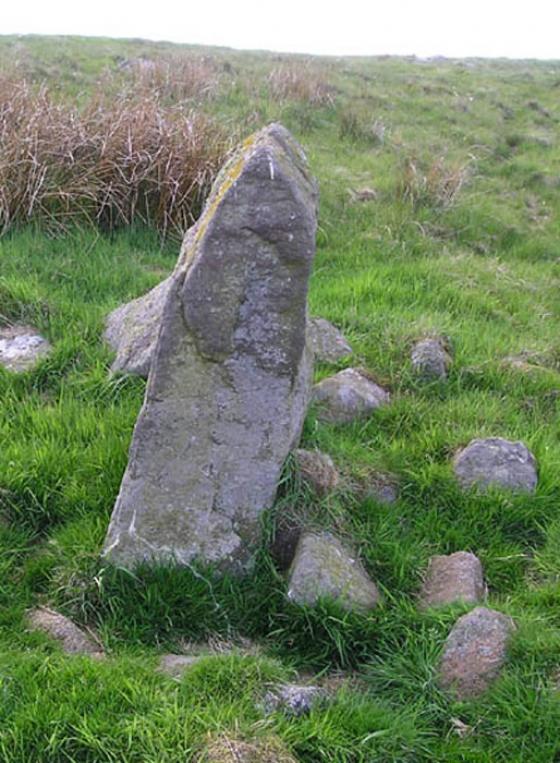
Split the De’il, Windy Gyle (NT 8563 1502)
Image credit: Rockandy
Split the De’il, Windy Gyle (NT 8563 1502)
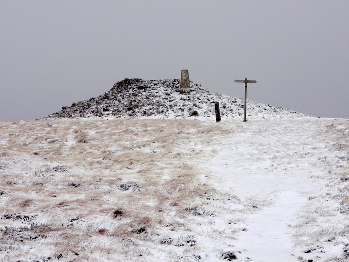
Russell’s Cairn, Windy Gyle (20 January 2012)

Just south-west of the 619m summit of Windy Gyle is the place name “Split the De’il”. David Dippie Dixon (Upper Coquetdale, 1903) describes this as an upright rock, some three feet in height. Another contradictory description (1915/16), reported by Rhiannon below, describes an upright slab of porphyry, about 6 feet high, on the southern slope of Windy Gyle, in a south-easterly direction from the cairns.
Pastscape describes it as a prehistoric standing stone at grid reference NT 8563 1502 pastscape.org.uk/hob.aspx?hob_id=1184023 a location where it is correctly shown on 1:10560 scale maps prior to 1925. However, it appears to have been descheduled (as a scheduled ancient monument) in 1998.
The place name has migrated to the west on modern large scale maps, where it has become associated with the cross border tracks, and the original map position marker (an open circle) which showed at its correct location, removed.
A recent visit geograph.org.uk/photo/2851698 shows that 3 feet is the more reasonable description of its size, the stone is no longer standing, and probably originally set up as a marker, rather than having a prehistoric origin. The place name though may indicate its former prominence.
A small cluster of other stones around the toppled slab may however indicate that it could have originally been part of a cairn. Many of its stones could have been depleted by the habit of generations of walkers removing stones to place on the greater eminence of Russell’s Cairn just to the north. Interestingly, Sir W Aitchison described a Bronze Age burial mound just south of this location in 1951, something that later surveyors couldn’t subsequently find keystothepast.info/durhamcc/K2P.nsf
A medieval cross known to have been set up somewhere in the vicinity, named as Maiden Cross, is discussed here canmore.rcahms.gov.uk/en/site/59012/details/maiden+cross/&biblio=more
Thanks to Rhiannon for putting the folklore here, it slowly galvanised me to finally get my sorry carcass ‘Up The Gyle’ and pay a visit to this far-flung edge of two countries.
There’s not much to say about the cairn that you wouldn’t be able to determine from the photo. It’s been used as a trig point and has the usual beacon sangar, unsurprising, given the spectacular views.
What did strike me about it was the variation of different kinds of stone represented in the cobbles and boulders. Were they brought from afar, were they brought in the bronze age, or have they been added by walkers on the last stretch of the Pennine Way? I’ve no idea.
I expected this place to be quiet, and was thus surprised to find I waited for over an hour before getting the place all to myself. The majority of other visitors were following the border line, some of them having completed the whole Pennine way. Kudos unto them. If you’re doing the Pennine way, you can’t really miss the thing. But if you’re coming from the east, it’s quite a decent walk up from Barrowburn, and on the path between Barrowburn and Murder Cleugh at about NT866118, there appears to be the remains of a prehistoric boundary in the form of the grounding stones of a cross dyke. I’d like to think it’s BA, there are quite a few of those hereabouts. As it’s not been recorded anywhere I’ve been able to find (Must get around to informing the CA about it), I can’t be sure. I also took no photos, nor did I gps the location. Lazy me.
It’d be easy to be so taken by the view from it’s place on top of Windy Gyle, that you’d assume the view was the reason for the choice of location for the cairn, and the handful of satellite cairns nearby. But I reckon the exact location on The Gyle is possibly influenced by the Routin Well and the strange chasm of Scotchman’s Ford. It would be redundant to list intervisible monuments, as there the extensive view means you could probably see half of the hill top cairns in Northumberland, and an equal number of the ones in what is now Scotland. Excellent views of Cheviot and Simonside for those who like a nice bit of ‘Sacred Hill’.
I had a quick skank about for the stone that used to be listed on the county SMR as a standing stone, in the area marked on the map as ‘Split the Deil’ (A peculiar name for a place where there’s nothing in particular, which no-one seems to be able to agree upon the etymology of). I found zilch, but it made for a nice excuse to hop about in the heather.
My return route was down what looks like a drove road, following the path amrked on the map down the western side of Wardlaw Burn, which comes out at Rowhope. I reckon this would be the sensible place to park a car for those who drove up this way. For those of a cycling bent, the Border County ride passes within spitting distance.
Russell’s Cairn at Windy Gyle is supposed to mark the site of the mysterious death of Lord Francis Russell in 1585. He was in a truce meeting with the Scottish Warden Thomas Ker at the time. It’s thought that he could have been bumped off as part of an English plot to remove Ker and other Catholic supporters of Queen Mary from their positions of power by implying they murdered him. The cairn’s thought to be Bronze Age though, and there are others along the ridge.
See:
archive.org/stream/uppercoquetdalen00dixo#page/51/mode/1up
A little word about ‘Split the De’il’ that Hob mentions:
An upright slab of porphyry, about 6 feet high, stands on the southern slope of Windy Gyle, in a south easterly direction from the cairns. The shepherds call this rock ‘Split the Deil’. It is not certain that this is a relic of prehistoric times, but the rock has all the appearance of being ‘set up’. A shepherd surprized a golden eagle percehed on this rock early one morning.
I love the final sentence. It’s like the author had been standing talking to a shepherd rave on about the eagle, and felt he just had to mention it in this otherwise quite sober account of stones. At least, that’s the only interpretation I can give it, unless eagles had something to do with the mysterious devil-related folklore attached to the stone.
From ‘Pre-Roman Remains in Upper Coquetdale’ by Mr Parker Brewis and Mr D D Dixon, in the Proceedings of the Society of Antiquaries of Newcastle upon Tyne, v7/8 (1915/16)
A photo of the cairn, which is apparently one of the largest in Northumberland.