23/05/2019 – Clach an Righ stone circle
23/05/2019 – Clach an Righ stone circle

23/05/2019 – Clach an Righ stone circle. Somebody looks after the grass very well.

23/05/2019 – Clach an Righ stone circle


The destruction – by man or Nature, I know not which – of the nearby bridge across the River Naver has ensured this wrecked ring retains a suitably ethereal vibe.

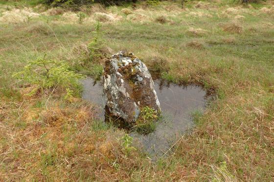
The ring surrounds the remains of a cairn.....


This looked an easy site to visit... however note that the bridge depicted across the River Naver at this point on the current 1:25k OS map DOES NOT EXIST!

Just the two stones now stand.... but I do believe here we once had a pocket-sized Stenness?
23/05/2019 – On the way back from visiting the stone rows to the south east we finally reached Clach an Righ. What a welcome sight. It’s a lovely looking circle. Not that big but the stones are a good size. Each upright stone’s axis is radial to the centre. Reminded me of The Great U of Stemster in that regard. I can’t think of others like this. I’m sure there are lots though. We plonked down on a nearby log to finished off our brews. Just taking in the scene.
With a nod to Gladman, it was finally time to head off again. His photos and fieldnotes had put an idea in our heads to seek out this place. He’s good at doing that.
Following a day spent wandering the (arguably) somewhat bleak, intimidatory (at least under massive leaden skies), indubitably wet landscape of Badanloch, an evening sojourn within Clach an Righ’s forestry clearing appeared to offer an appropriate, conciliatory contrast before settling down for the night... or at least what passes for ‘night’ in these far northern outlands in late May. Now although I’m aware that “To expect the unexpected shows a thoroughly modern intellect”... or at least according to the splendidly caustic brain of Mr Wilde... I’d contest a somewhat pragmatic disposition based upon practical experience – I’d hesitate to call it cynicism – is probably nearer the mark in my case.
Whatever the source of this personal stoicism – damn it to blazes when all I want is an easy life – it is once again soon put to practical use. Yeah, upon arriving at the expected footbridge shown crossing the River Naver (immediately opposite the stone circle) on the current 1:25K map... said bridge is nowhere to be seen. No sign of debris, nothing. Troll hunters please take note. Nothing to see here.... move along please. Which is what stone circle seekers must also do, heading north on the B873 to Ceann-na-coille where successive wooden suspension bridges – for, please note, ‘the exclusive use of local fishermen’ – afford access to the far bank of the river, via an islet. Making the – perhaps unfounded – assumption that said ‘sportsmen’ would not begrudge my passage, my relief at remaining dry-shod is immediately tempered by the realisation that an unclimbable deer fence comprehensively bars access to the forestry track beyond. So, no early evening stroll, then, but a rough, soggy trek along the river bank in the face of a sustained cacophony from the bloody dog across the water. After almost a mile (I think, maybe less) a stile is finally forthcoming, and, eventually, the forestry clearing bearing stone circle. Not before time, too.
Despite just the two stones remaining upright, Clach an Righ proves well worth the effort. For me this is, in no small way, due to the manner in which the now fallen stones preserve the integrity of the ring, maintaining its circumference, its inherent symmetry. Furthermore they – erect and prostrate monoliths alike – are beautiful specimens, still surrounding a low, grassy cairn of some former VIP; presumably not ‘our Harald’, as old man Steptoe might have said, but someone laid to rest (in whatever form) at a much earlier date. In fact the impression I have is that Clach an Righ more resembles an Irish site than Scottish... something akin to Ardgroom, perhaps?.. which is certainly a favourable comparison, indeed.
An information board provides visitors – should any happen to pass this way following the removal, by natural causes or otherwise, of the former bridge – with a precis of the events responsible for generating such stirring local legend... the towering treeline, shifting audibly in the breeze, somehow synonymous with the last resting place of great warriors of yore; if not stricken, dying men crying out for their mothers with last gasps of humanity. Whether those apparently nearby ‘clearance cairns’ did, in fact, once protect such battlefield casualties from the opportunistic attentions of wild animals is perhaps a moot point. For the shattered, yet still haunting monument of Clach na Righ continues to mark the passing of one enigmatic local millennia ago.
Conditions upon the ground may not be at all favourable nowadays and, owing to the unforeseen trek, I reach the car exhausted, nearing dusk, thus necessitating a wild camp overlooking Loch Naver. However there was something about Clagh an Righ I really liked. Couldn’t quite define what it was, to be honest. Which is no doubt part of the appeal.
Clach an Righ circle is now in a forest clearing. Two stones remain standing opposite each other; one is 6ft high, the other 8ft. Other stones from 5ft to 9ft lie fallen.
‘Clach an Righ’ means ‘King’s Stone’. The stones were also known as ‘King Harrald’s Pillars’. They were said to commemorate a victory of King William the Lion (or perhaps his army, led by Ragnvald Gudrodson / Reginald of the Isles) over a Norse army (led by Harald Madadson, Earl of Caithness) in 1196 or 1198.
Field clearance heaps in the area were said to be the burial mounds of the dead soldiers, including Harald Madadson, from whom another alternative name ‘Dalharrold’ (or Dailharraild), is said to be derived. The mounds have now been ploughed and planted with trees.
Info from the Canmore record.
rcahms.gov.uk/pls/portal/newcanmore.details_gis?inumlink=5540